A
Cultural History of Three
Traditional Hawaiian Sites
on the
West Coast of Hawai'i Island
Overview of Hawaiian History
by Diane Lee Rhodes
(with some additions by Linda Wedel Greene)
|
Chapter 9: Pu'uhonua o Honaunau
National Historical Park A. Setting Pu'uohonua o Hoaunau, "Place of Refuge of Honauhau," is located in the ahupua'a of Honauhau, in South Kona, on the west coast of the Island of Hawai'i. The present park includes the coastal portions of three ancient land divisions: Honaunau, Keokea, and Ki'ilae. It lies about midway between the larger towns of Kailua to the north and Miloli'i to the south. Located next to the ocean, the park is reached via a secondary road off the Mamalahoa Highway. It consists here of a large flat tongue of pahoehoe lava flanked by three bays, Honaunau to the north and Alahaka and Ki'ilae to the south. In the vicinity of Honaunau Bay, the park includes the refuge itself, nearby palace grounds, royal fishponds, a royal canoe landing area, stone house platforms, and temple structures. The boundaries of the refuge are formed by a wall starting at Honaunau Bay and extending in a southwesterly direction for more than 600 feet, at which point a leg turns to the west and runs again southwesterly about 400 feet toward the sea.
Here, as elsewhere along the Kona Coast, lava flows (these from Mauna Loa) are the dominating coastline feature. The refuge is situated on a tongue or small peninsula of black pahoehoe lava jutting into the ocean and forming the southwest wall of Honaunau (Ke Awa) Bay. Within the curve of the bay nestles the small village of Honaunau, once the home of chiefly retainers and commoners, now supporting only a small number of houses. From here one can see what is perhaps the most spectacular natural feature of the park — the Keanae'e pali (cliff), a fault scarp paralleling the shore about one-tenth of a mile inland. The imposing appearance of the cliff, which is arc shaped, more than 100 feet high, and 1,000 feet long, is due to the metallic-hued ancient lava flows frozen in time as they cascaded over the cliff edge toward the sea, creating "festoon lava." The early inhabitants used the numerous cave openings and lava tubes in the cliff face as residences, burial chambers, and possibly for refuge from the elements. From the ocean inland to the beach the area that used to be barren, dry, open, and dotted with scattered large lava boulders (deposited by tidal action or brought in for construction purposes) is now overgrown with koahaole and opiuma. The area historically supported stands of pill grass used for thatching houses, pandanus, kou, kamani, and noni, with cocoanut palms providing some shade around the refuge itself. About a mile inland, the scene changes to dense foliage as a result of the more abundant rainfall and the presence of decomposed lava. The early Hawaiians appreciated this area's fertility and their descendants continue to utilize it for growing large quantities of coffee, macadamia nuts, plumeria, avocados, papayas, and other tropical fruits. North about four miles on the Kona Coast is Kealakekua Bay, the scene of the second significant contact between native Hawaiians and Europeans. It was there, at the site of the early Hawaiian villages of Napo'opo'o and Ka'awaloa, that Captain Cook's ships, the Resolution and Discovery, dropped anchor after discovering Kaua'i in 1778. There Cook was worshipped as the physical manifestation of the god Lono in the temple of Hikiau. And there he eventually lost his life during a sudden battle with the natives at the water's edge near Ka'awaloa. A monument on the north side of the bay marks his death site. Hikiau Heiau, restored in 1917, stands on the east side of the bay. The area between Kealakekua and Honaunau bays is renowned as the Moku'ohai battleground, site of the 1782 conflict between the forces of Kamehameha and those of Kiwala'o for dominance over the island after the death of Kalani'opu'u, king of Hawai'i at the time of European contact. Kamehameha's troops succeeded in killing Kiwala'o and routing his warriors, although the latter's half-brother Keoua escaped to carry on the battle until his own death at the hands of Kamehameha's followers at Pu'ukohola Heiau. Immediately south of the refuge, in Keokea, a satellite village of scattered residential sites, including that of King Keawe, hugged the coast in ancient times. Inland remains of this settlement consist of two heiau, a holua, and the burial cliffs mentioned earlier. A little farther south, within the present southern boundary of the park, is a portion of Ki'ilae Village, occupied from prehistoric times until 1926. There residences arose around a well, called Wai-ku'i-o-Kekela, named for Kekela, a resident of the area, daughter of John Young and mother of Queen Emma. Nearby are lava tube refuge caves useful in time of war. Today the refuge and associated residential and temple sites, walls, trails, and village remains are in ruins. Non-native shrubs and trees, vines, and a dense undergrowth of grass form a thick cover over the pahoehoe lava flow, which is periodically exterminated in an attempt to restore the landscape of the eighteenth century and expose significant archaeological features. Park facilities include a visitor center, parking lot, headquarters building, and a picnic area.
B. Description of Refuge Area Early in the area's prehistory, a ruling chief declared the tongue of black lava flow extending out into the ocean southwest of the bay a sanctuary protected by the gods. There kapu breakers, defeated warriors, and criminals could find safety when their lives were threatened if they could reach the enclosure before their pursuers caught them. A massive stone wall around the sanctuary marked the boundary, while a heiau within the walls afforded spiritual protection. Later a temple was built at the north end of the wall to hold the sacred bones of the ruling dynasty, who would act as perennial guardians of the pu'uhonua. The refuge site today consists of an area partially surrounded by a thousand-foot-long wall of pahoehoe lava about seventeen feet thick and ten feet high. The north side of the structure is open to the bay and the west side to the sea. Within or next to the enclosure were several significant structures, including the Hale-o-Keawe, the 'Ale'ale'a Heiau, the "Old Heiau," and the Hale-o-Papa (Women's Heiau). Other notable features include a konane stone (papamu), a fisherman's shrine, and two large stones, one reportedly serving as a hiding place for Queen Ka'ahumanu during a quarrel with her husband King Kamehameha and the other used by Chief Keoua. A small enclosure east of Hale-o-Keawe contains two fishponds used by Hawaiian royalty. The Hale-o-Keawe housed the bones of the paramount chiefs descended from 'Umi and Liloa, some placed in wicker caskets woven in anthropomorphic shapes. This sepulchre of the very high ali'i lent Honaunau its great sanctity. The entire area surrounding the complex was densely settled in aboriginal times and is now replete with significant archeological remains. It is clear that a well-organized society once flourished in this area. Archeological features here illustrate all aspects of ancient society relating to the religious, economic, social, and political life of early Hawaiians. This way of life began disappearing with Cook's arrival in 1778 and underwent more deterioration when Liholiho abolished the kapu system in 1819.
C. Development of Honaunau Ahupua'a As described earlier in this study, the sheltered, temperate Kona Coast of Hawai'i became an ideal settlement area for the early Polynesian peoples who migrated to the Hawaiian Islands. The calm waters of Honaunau Bay provided abundant fish and other marine resources, while its gentle upland slopes offered conditions conducive to the growth of abundant crops of taro, bananas, sweet potatoes, sugarcane, and later, breadfruit. Also available were stands of hardwood trees for constructing residences and religious structures and for manufacturing canoes. Much of Honaunau Bay's attraction lay in its sheltered sandy beaches where canoes could easily land. A number of brackish springs, actually tide pools in which fresh water from rain and natural seepage accumulated on the surface of the salt water, provided a dependable water supply. It is not surprising the cove quickly became a favorite residence of Hawaiian royalty. The refuge was an important part of Honaunau, the traditional seat of the chiefdom of Kona. The ruling chief and his court occupied the area at the head of Honaunau Bay and along the shore to the south. Lesser chiefs and commoners serving the court and priests resided on the north shore of the bay, toward the mountains, and possibly at Keokea and Ki'ilae villages to the south. All residences were basically one-room, wooden framework, thatched-roof structures. The chief's complex would have consisted of several houses. The ancient village of Honaunau was the ancestral home of the Kamehameha dynasty, serving in ancient times as a major Hawaiian religious and cultural center. In 1823 William Ellis noted that "Honaunau . . . was formerly a place of considerable importance, having been the frequent residence of the kings of Hawaii, for several successive generations." When King Keawe-i kekahi-ali'i-o-ka-moku of Kona, Kamehameha's great-grandfather, died about 1650, his bones were placed in a temple constructed on a platform next to the refuge. His mana, inherited from his ancestral gods, and that of his descendants became the power protecting the refuge at Honaunau. The structure in which his remains reposed, the Hale-o-Keawe, became a royal mausoleum, holding the bones of several more of Kamehameha's ancestors and thereby endowing the area with extreme sacredness and the refuge with powerful guardian spirits. Although the canoe traffic of ancient times moved easily in and out of the small harbor of Honaunau Bay, the water was not deep enough to accommodate the European and American trading ships that began arriving in Hawai'i late in the eighteenth century. For that reason Kamehameha and other ali'i anxious to initiate social and economic interaction with foreigners moved to other harbors, such as Kailua and Honolulu. This was the beginning of the decline in Honaunau's importance, which increased with the abolition of the kapu system in 1819, at which time the benefits of absolution and forgiveness provided by places of refuge became unnecessary. Honaunau over the years declined in population as it changed in character from a royal residence of kings, a religious and political center, and a refuge site to just another seacoast village that gradually lost inhabitants to the upland sections in the 1840s as happened in other places. In the Great Mahele, the ahupua'a of Honaunau went to Miriam Kekau'onohi, a granddaughter of Kamehameha. She took as her second husband Levi Ha'alelea, a descendant of the Kona chiefs, who inherited Honaunau when she died. After his death, the administrator of his estate sold the land at auction in 1866 to W. C. Jones, agent for Charles Kana'ina, the father of King Lunalilo. Because Jones never paid for the land, Charles R. Bishop bought it in 1867 as a present for his wife, Bernice Pauahi. Six years after her death, Bishop deeded Honaunau to the Trustees of the Bishop Estate who leased the portion occupied by the refuge to S.M. Damon. In 1921 the county of Hawai'i leased the pu'uhonua and the adjoining picnic area from the Bishop Estate for use as a county park. In 1959 the federal government obtained 165 acres, including the ancient refuge, from the Trustees for the establishment of a national park. Part of the land was from the ahupua'a of Honaunau and part from Keokea. Kamehameha Ill had granted the ahupua'a of Keokea to Kekuanaoa in 1848; his daughter, Ruth Ke'elikolani, acquired it upon his death in 1868. At her death in 1883, the land went to her cousin Bernice P. Bishop. D. Places of Refuge 1. Types In ancient Hawai'i, during times of war, old men, women, and children from surrounding districts fled to places of safety, either in the mountains, in caves, or to pu'uhonua to await the outcome of the conflict in safety and to escape reprisal if their warriors met defeat. William Ellis noted that
Pu'uhonua translates literally as pu'u (hill), honua (earth). Possibly the word pertained originally to a fortress on a hill, which is also implied by Ellis's quotation above and one from Samuel Kamakau presented a little later in this section. The term is also applied to cave refuges, which were actually large lava tubes into which small groups of people fled from a pursuing enemy. Sometimes stone walls across the entrances allowed only one person at a time to enter, in a stooped position, providing defensive advantage for those inside. Places of refuge were a necessary adaptation because of the particular culture of the early Hawaiians, regimented as it was by the kapu system of prescribed behavior, and preoccupied as its leaders became in achieving power and authority — pursuits that frequently dictated conflict and wars. 2. Origins According to the historian Marion Kelly, the Hawaiian concept of asylum and its various elements evolved as a natural outgrowth of institutions and cultural patterns that already formed an established part of Polynesian society. These arrived in Hawai'i as part of the general pool of cultural knowledge and were elaborated upon and refined to conform with evolving Hawaiian beliefs related to the supreme sacredness and inherited power of ruling chiefs. As Kelly states,
Anthropologist Kenneth Emory's views supported this statement. He determined that the sanctity of a place of refuge related directly not only to the inherited sacred power of the chief who established it but also to his ability to maintain political control of the district. 3. Historical Associations with Hebraic Cities of Refuge Early European visitors to Honaunau, trying to place the Hawaiian term pu'uhonua within a context they could understand, used the term "city of refuge" for this area. Although it little resembled the cities of refuge in Jerusalem, because it was neither a city or even a settlement and because protection was granted to both the innocent and the guilty, the name clung to the site through succeeding generations of visitors and scholars. A "logical" conclusion of this misnomer was that the Hawaiian people must have descended from one of the lost Hebrew tribes. Abraham Fornander dedicated a paragraph in his first volume on the Polynesian race to "Cities of Refuge," sacred areas that he noted had often been discussed as "another instance of Hebraic influence upon the customs and culture of the Hawaiians." Even King Kalakaua, in describing the two Pu'uhonua, or places of refuge, on Hawai'i Island, went so far as to venture that their existence suggested "a Polynesian contact with the descendants of Abraham far back in the past, if not a kinship with one of the scattered tribes of Israel." 4. Use Within Hawaiian Culture Access to the pu'uhonua o Honaunau would have been gained by land from the south or by swimming into it from the north. The presence of the palace complex just east of the refuge prohibited entry from that side; the kapu system ordered immediate death for a commoner who set foot or cast a shadow on a royal residential area. The pu'uhonua was a place that was always open, and anyone who reached it was assured of protection no matter their class or type of infraction. A large, enclosed refuge such as the one at Honaunau was considered extremely safe not only because of the physical barrier of the surrounding wall but also because the presence of a heiau within or near the walls assured the protecting influence of guardian deities. Fleeing to one of these places was the only escape from death for a criminal, vanquished warrior, or kapu violator. These designated sacred sites offered the chance to be purified by a kahuna pule for one's sins and to resume life in the community free of the fear of punishment. Kelly, in describing the interrelationship in a pu'uhonua between spiritual mana and personal safety, suggested that
De Freycinet described Hawaiian pu'uhonua enclosures in 1819 in some detail:
Constance Cumming had been told that, having crossed the threshold of the refuge and attained sanctuary, "The first act of the fugitive was to give thanks in presence of the image of Keave, and he was then allowed to rest in one of the houses built specially for refugees, within the sanctuary. . . . This concept of providing places of safety was recognized throughout the Hawaiian Islands, resulting in a functioning pu'uhonua in each district throughout ancient times. Designated pu'uhonua changed over time with changing policies. The refuge at Honaunau was the largest walled one in Hawai'i and is thought to have been the most continuously used. Today it is also the best preserved. Established by the Kona chiefs in prehistoric times, it functioned into the historic period. 5. Use During Reign of Kamehameha After consolidating his power, Kamehameha abolished most of the old pu'uhonua, distributing them to his war leaders, and established new ones. Only Kaua'i, never the scene of Kamehameha's conflicts, retained all its original refuges. Kamakau states that prior to Kamehameha's rise to power there had been pu'uhonua on Hawai'i Island in Kohala, Hamakua, Hilo, Puna, and Ka'u. But when the Kona chiefs gained ascendancy, only the pu'uhonua at Honaunau was kept, either because the Kona chiefs were supreme or because the land was so dry it was of little other use. Samuel Kamakau also discussed the fact that not only places but people were considered pu'uhonua:
Designation as a pu'uhonua was applied to high chiefs because of their position as rulers, a position supported by the mana or sacred power they had inherited from their ancestors and that gave them the right to spare lives or extend mercy. As ruling chief, Kamehameha
E. Pu'uhonua o Honaunau 1. Early Descriptions by Europeans Early accounts of the pu'uhonua o Honaunau consist primarily of descriptions of the Hale-o Keawe and/or brief mention of the dimensions and configuration of the Great Wall. In the historic period a number of early European visitors and missionaries saw, were impressed by, and even tried to depict on paper, the thatched mausoleum of Hale-o-Keawe and its associated refuge. Because this temple was left to deteriorate after other religious structures had been destroyed, it afforded a final view of the relics, and a parting reflection on the kapu, that had comprised such an essential part of the ancient Hawaiian religion. These early accounts provide our only historical picture of the remains of the pu'uhonua at Honaunau. a) Cook Expedition, 1779 The first known visit by Europeans to the pu'uhonua at Honaunau was by some of Captain Cook's officers in March 1779. Lieutenant James King recorded that
b) Archibald Menzies, 1793 The second recorded sojourn in the area was a brief one, on February 28, 1793, by Archibald Menzies, botanist of the Vancouver expedition, who arrived in the village of Honaunau at the tail end of an exploratory expedition into the uplands behind Kealekekua Bay. He and his companions
After a soothing massage, and after contracting with the inhabitants to provide water for their ships, Menzies and his companions spent an uneventful night in the village. Little interested in ethnography, Menzies seemed unimpressed by the presence of the refuge or its meaning in Hawaiian culture. He mentions only that during the night, "in a large marae close to us we now and then heard the hollow sounding drums of the priests who were up in the dead hour of the night performing their religious rites." c) John Papa I'i, 1817 John Papa I'i, a participant in, and observer of, Hawaiian public affairs as a companion of Liholiho, stated that Kamehameha's son regularly visited the Hale-o-Keawe during his journeys to various luakini as his father's representative in those rituals necessary to replenish their mana. Liholiho would begin this series of prescribed visits in Kailua, proceed up the coast to Kawaihae, and then continue on around the island, finally stopping at Hale-o-Keawe. The following is the only eye-witness account of an official state visit to the Hale-o-Keawe, made in 1817, and of the accompanying rituals:
d) Reverend William Ellis, 1823 The first detailed description of this "city of refuge" by a foreigner was penned by the Reverend William Ellis while visiting the area on his tour of the island with representatives of the Board of Commissioners for Foreign Missions. Very interested in learning all he could about Hawaiian society and religious beliefs, and already acquainted with many aspects of the culture and able to speak the language, he immediately realized the significance of the pu'uhonua. He was less impressed by the village of Honaunau, which then contained about 147 houses. Despite the large number of dwellings, the only accommodations he and his companions could find consisted of a mat spread on the ground in an open canoe shed. There they passed their nights, beset by ''swarms of vermin" and "the unwelcome intrusion of hogs and dogs of every description." Because Ellis was feeling the effects of indigestion, thought to have been caused by drinking the brackish water along the coast, he and his party tarried in the area for another couple of days while he recuperated. During that time his companions examined the surrounding countryside. Inland two to four miles they found a prosperous population living comfortably in comparison to those on the coast. Breadfruit trees, cocoanuts, and prickly pear thrived in large groves. By this time, the pu'uhonua at Honaunau had been abandoned for four years. Ellis and his companions were quite impressed by the Hale-o-Keawe, although they were unable to understand why it had not been destroyed during the general destruction attending the abolition of the kapu system. Ellis's description of the structure is lengthy but irreplaceable in providing some idea of its original appearance:
Ellis and his companions found the refuge, signifying clemency and empathy with the plight of the common people, a refreshing change to the deserted "heathen" temples and abandoned altars that conjured up vastly different pictures, those of "human immolations and shocking cruelties." Many of the later visitors to the area based their descriptions on this account by Ellis, adding few other relevant details or observations.
e) Andrew Bloxam, 1825 Two years later, in 1825, the British frigate Blonde, commanded by Captain (Lord) Byron, came to Hawai'i to return the bodies of Kamehameha II and his queen, Kamamalu, who had succumbed to measles during a royal visit to England the previous year. On board ship were Naturalist Andrew Bloxam and Botanist James Macrae. During their sojourn in the islands, these men visited a number of ports and sites of interest. In addition, Byron was more than willing to serve as an ally to the Hawaiian high chiefs in their efforts to promote Christianity by removing all sacred objects from the Hale-o-Keawe. Liholiho's death had resulted in Kauikeaouli's ascendancy as Kamehameha Ill. Because the new ruler was underage, Kalanimoku served as regent and co ruler with Ka'ahumanu. Both were new converts to Christianity, Kalanimoku specifically giving Byron permission to remove articles from the temple. On the morning of July 15, 1825, Bloxam reported that
This account does not mention the images within the enclosure that Ellis noted nor those on the fence. Byron's account, presented later, however, does mention images within the courtyard. Bloxam added to the significance of his visit by making sketches of the exterior of the Hale-o Keawe and of its interior arrangement.
f) Reverend Rowland Bloxam, 1825 The Reverend Rowland Bloxam, Andrew's uncle, added a few details on the Hale-o-Keawe's interior furnishings:
g) Lord G. A. Byron, 1825 Lord Byron's account of this trip provides additional information of interest and importance:
The two high chiefs accompanying Byron, Kuakini (governor of the island of Hawai'i) and Na'ihe (chief of South Kona and guardian of the Hale-o-Keawe), were somewhat disturbed by this looting of the temple, but remained silent. They did, however, prevent removal of the bones.
h) James Macrae, 1825 Botanist James Macrae, not a member of the first tourist party off the Blonde, visited the pu'uhonua the next day:
The Blonde's artist, Robert Dampier, contributed to this documentation by sketching the Hale-o Keawe, producing a rather stylized rendering of the structure against a background more closely resembling Kealakekua Bay to the north. An engraving made from that drawing accompanied the formal report of the voyage and is a valuable source of information on the appearance of the structure. It should be noted that because the crew of the Blonde removed many of the Hale-o Keawe images, they have been preserved in a number of private collections and museums both in the United States and Europe and provide an important record of early Hawaiian religious art that might otherwise have been lost. i) Laura Judd, 1828 The next foreign visitor who left an account of the pu'uhonua was Laura Fish Judd. She came to Hawai'i Island in 1828 in company with her missionary/physician husband, Gerrit P. Judd, who was part of a committee exploring a site for a health station on the nearby mountain slopes. The failing health of many of the pioneer missionaries had become a source of concern, and it was believed that a station in the bracing mountain atmosphere might be good for them (Waimea in North Kohala was later selected). During Mrs. Judd's residence at Ka'awaloa she visited the temple at Honaunau accompanied by Na'ihe and Kapi'olani:
j) Later References to the Site Chester Lyman, a Yale University scientist visiting Hawai'i, sketched the pu'uhonua in 1846, his map showing that the area between the Great Wall, the Hale-o-Keawe, and the northeast end of 'Ale'ale'a Heiau was fenced off as a goat pen. Lyman writes that on December 2, 1846,
English author Samuel Hill visited Honaunau in the late 1840s and found a village containing about forty huts with not more than 100 residents. He described the pu'uhonua enclosure as having walls only three to four feet high and being full of coconut trees. The village and refuge ruins also rated only slight mention from George Bowser who, while compiling a directory of the Hawaiian kingdom in the early 1880s, noted at Honaunau only
D. Harvey Hitchcock, a Hilo artist, sketched the refuge area in 1889 and depicted many of the major structures and features.
2. Early History a) Original Chronology of Pu'uhonua Development Information on the erection of structures at Pu'uhonua o Honaunau has come primarily from ancient Hawaiian oral traditions, early European travel accounts, oral history from residents who once lived in the area, and archeological fieldwork from the early 1900s to the present time. Samuel Kamakau made the following statement concerning the setting aside of the refuge and construction of the Hale-o-Keawe:
Abraham Fornander stated that Kanuha, son of Keawe-i-kekahi-ali'i-o-ka-moku built the Hale-o-Keawe. A chronology of the establishment of the pu'uhonua and construction of the various heiau and other features within it has been subject to change and revision over the years. Anthropologist Dorothy Barrère first attempted in 1957 to determine the prehistoric use of the pu'uhonua at Honaunau, a project hampered by the lack of much traditional knowledge. Several sketchy oral traditions, her own genealogical studies, and archeological data accumulated to that time convinced her that the refuge had undergone three main phases of construction. These began with the erection of the open platform temple now referred to as the "Old Heiau," which she thought probably provided the initial protective mana for the refuge. Next came 'Ale'ale'a Heiau and finally Hale-o-Keawe. Barrère surmised that the Great Wall had been built during either the first or second phase of construction. Barrère found it extremely difficult to determine when the original pu'uhonua had been set aside, although her genealogical work deduced that the first chief who would have held uncontested control over his kingdom and thus would have been in a position to establish and maintain the sanctity of the refuge was 'Ehu-kai-malino, the ruling chief of Kona and a contemporary of Liloa, the supreme chief of the island. Both men were active about 1475 A.D. If 'Ehu had established a pu'uhonua at this time it probably would have been primarily intended for kapu breakers, because there was no inter-chiefdom rivalry in progress that would have necessitated a war refuge. Barrère theorized that the first heiau took form at this time in association with the pu'uhonua. Open to conjecture was the question of what happened to the refuge under 'Umi, Liloa's son, who inherited his supreme power. As new ruler, he could either have abolished the pu'uhonua completely or have reaffirmed its sanctity. The next mention Barrère found of the pu'uhonua at Honaunau surfaced four generations after 'Umi, after the line of inheritance of the Kona chiefs had been firmly established through 'Umi's descendants. One tradition states that it was Keawe-ku-i ke-ka'ai, a son of Keakealani-kane, ruler of Kona, Kohala, and Ka'u three generations after 'Umi, who built the pu'uhonua and Hale-o-Keawe. Other traditions state the latter was built for Keawe-i kekahi-ali'i-o-ka-moku, living two generations after the other Keawe. Archaeological evidence at that time indicated that the eastern segment of the Great Wall originally ran north to the water's edge and that a portion of it had been removed for construction of the Hale-o-Keawe. On the basis of what was known at that time, Barrère believed it was possible to accept both traditional explanations — that Keawe-ku-i-ke-ka'ai had reconstructed the old pu'uhonua by building the 'Ale'ale'a Heiau platform, and maybe the Great Wall, and that the Hale-o-Keawe was built for Keawe-i-kekahi-ali'i-o-ka-moku, Kamehameha's great-grandfather, in a later period, ca. A.D. 1650.
b) New Archeological Data Forces Revisions to Chronology After Barrère had developed this chronology, important new information came to light through the excavation of 'Ale'ale'a Heiau in 1963. That work showed that this structure had passed through seven developmental stages, described as 'Ale'ale'a I-VII. On the basis of those findings, NPS Archeologist Edmund Ladd, of the Pacific Area Office, revised the construction chronology in several respects. He theorized that sometime prior to A.D. 1475, the "Old Heiau" and stages I to III of the 'Ale'ale'a Heiau were built, the pu'uohuna possibly being in existence at that time. (Heiau could exist independently of a sanctuary, but a sanctuary would not be viable without an associated heiau to add spiritual protection.) About A.D. 1475, Ladd believed, 'Ehu-kai-malino added stage IV onto 'Ale'ale'a III. At that time he could have reaffirmed an existing pu'uhonua or might have established the original one. About A.D. 1500 'Umi possibly reaffirmed the earlier pu'uhonua by adding stages V and VI to 'Ale'ale'a. Ladd theorized that about A.D. 1600, Keawe-ku-i-ke-ka'ai reaffirmed the pu'uhonua by building stage VII of 'Ale'ale'a around stage VI. Ladd then suggested that in A.D. 1650, 'Ale'ale'a VII was abandoned when the Hale-o-Keawe was built for Keawe-i-kekahi-ali'i-o-ka-moku. On the basis of the new archeological evidence, Barrère also took another look and revised her chronology, tossing out some basic assumptions she had made earlier and suggesting that the "Old Heiau" had been constructed by Pili-ka'aiea, the new ruler Pa'ao installed in the islands, in the thirteenth century; 'Ehu-kai-malino had then constructed 'Ale'ale'a I at the same time he established the pu'uhonua, about A.D. 1425; 'Umi then enlarged 'Ale'ale'a in stages II, Ill, and IV and possibly constructed the Great Wall, ca. A.D. 1500 (based on Apple); Keawe-ku-i-ke-ka'ai further enlarged 'Ale'ale'a in stage V ca. A.D. 1625 (Apple); and then Keawe-i-kekahi-ali'i-o-ka moku enlarged 'Ale'ale'a in stage VI in ca. A.D. 1675 (Apple). Barrère added a new twist by suggesting that Kamehameha enlarged 'Ale'ale'a in stage VII sometime between 1793 and 1803 and then constructed Hale-o-Keawe between 1813 and 1819. Supporting her theory on the refuge's longevity, Barrère cited a traditional legend from very ancient times describing what rites a priest followed after a refugee entered the pu'uhonua o Honaunau. The legend validates later stories of the area's being an ancient place of refuge, of the inviolability of its kapu, and of the presence of guards to enforce its sanctity and of kahuna who performed religious rites and ceremonies. It is known that during the Battle of Moku'ohai in 1782, men, women, and children of the camps of both sides took refuge in this pu'uhonua. In addition, Reverend Ellis noted an account of the area serving as a refuge for warriors retreating from that battle after the death of Kiwala'o. Further data from the archeological work on the "Old Heiau conducted during 1979 to 1980 appeared to show that stage I of 'Ale'ale'a predated the "Old Heiau" and might even be 200 years older than originally thought. In a final effort to clarify the sequence of events, Ladd conjectured that 'Ale'ale'a I had been built ca. A.D. 1250 by an unknown person; 'Ale'ale'a II and III were added ca. A.D. 1250-1475 by another unknown builder; the "Old Heiau was then constructed ca. A.D. 1350, influenced by the teachings of Pa'ao and Pili; 'Ehu-kai-malino added 'Ale'ale'a IV ca. A.D. 1475 and also established the pu'uhonua; 'Umi added 'Ale'ale'a V and VI ca. A.D. 1500 and also possibly reaffirmed 'Ehu's pu'uhonua; Keawe-ku-i-ke-ka'ai added 'Ale'ale'a VII ca. A.D. 1600, when the Great Wall was constructed; and finally Keawe-i-kekahi-ali'i-o-ka-moku built the Hale-o Keawe by removing a portion of the Great Wall ca. A.D. 1650. 3. Later History of the Pu'uhonua and of Hale-o-Keawe The pu'uhonua, as indicated, was not needed as a sanctuary after the abolition of the ancient Hawaiian kapu system. The Hale-o-Keawe was spared destruction at that time possibly because of its special status and its extreme sacredness due to its connection with the Kamehameha dynasty and its function as the repository for the ancestral bones of the reigning family. Russell Apple has theorized that possibly Liholiho himself, in agreement with Ka'ahumanu, decided to retain the repository of his famous ancestors' bones as a "royal mausoleum of the Kamehameha dynasty." Despite the acculturation taking place in Hawai'i at that time, many continued to adhere to the old traditions. Although worship at the old temples and of the old gods was almost impossible with their destruction after 1819, the fact that Hale-o-Keawe still existed provided opportunities for relic worship and placement of offerings to ancestors. Ka'ahumanu and others who had converted to Christianity considered this a pagan and objectionable practice and probably an embarrassment. Therefore, threats to the structure's existence arose with the visit of the regent Ka'ahumanu to the Hale-o-Keawe in 1829. Ka'ahumanu was a strong convert to Christianity and steadfastly resolved to completely sever Hawaiian ties to the old religion by getting rid of this last vestige of "paganism." Missionary Hiram Bingham recounted that
The removal of the bones took place in late December 1828 or early January 1829, and at least partial destruction of the house occurred soon thereafter. The deified bones were removed from Hale-o-Keawe and placed in two large coffins, or wooden boxes, which were secretly interred in Hoaiku cave in the Ka'awaloa cliffs at Kealakekua Bay, where they remained for almost thirty years. Sometime afterwards (ca. 1836?) the Hale-o-Keawe's surrounding fence was dismantled and its sacred timbers and perhaps part of the palisade were used in construction of a government building in Honolulu. According to Professor W.D. Alexander, in January 1858 Kamehameha IV toured the windward islands in the British sloop Vixen commanded by Captain Meacham. Arriving at Ka'awaloa, he ordered the keeper of the royal burial cave to unseal it during the night and allow the coffins from Honaunau to be loaded on board ship. Transported to Honolulu, they were entrusted to the protection of Governor Kekuanaoa, who was also official guardian of royal tombs. In 1865, after completion of the royal mausoleum in Nu'uanu, the coffins were carried there during the night in a torchlight procession and laid to rest.
Missionary Levi Chamberlain had been present at the removal of the bones from Hale-o-Keawe and listed the names of the chiefs whose bones went to Ka'awaloa. Barrère, after studying the list and genealogies, discovered that possibly as many as sixteen of the chiefs were direct descendants of one chiefly mating. She concluded, therefore, that Hale-o-Keawe was primarily the depository of bones of one family descended from Keawe-nui-a-'Umi, whose son was the first hereditary ruler of Kona. The earliest interments in the house were probably designated for deification as ancestral gods for the next generations. Not all descendants of the family were placed there, notable exclusions being that of women, because this was a heiau, and of priests, a class that could not be be deified. Several questions concerning the Hale-o-Keawe remain unresolved. After being emptied of relics, and after souvenir pieces of kauila wood had been given to the missionaries, what happened to the structure? It appears to have remained standing, possibly by intention on the part of Ka'ahumanu, who either believed that the removal of relics had so decreased its power among the people that it no longer posed a threat to Christian beliefs or who left it to Na'ihe to destroy. Na'ihe continued as guardian of the bones secreted in the cave in the Kealakekua cliffs until his death in 1831, and he might have managed to procrastinate on the house's destruction until Ka'ahumanu's death that same year. Missionaries Ephraim W. Clark and Levi Chamberlain saw the Hale-o-Keawe still standing in February 1829 as they passed in a canoe by Honaunau Bay, and the Reverend John D. Paris noted it again in 1841. Yale astronomer and surveyor Chester Lyman, visiting in Hawai'i, noted in 1846 the walls "yet quite entire," the stone foundation of the Hale, and remains of the wooden palisade. Henry Cheever stated about 1850 that only a fence of posts remained on site, and Samuel Hill about the same time spoke of a few stakes remaining as well as the temple refuse pit. A series of earthquakes beginning in 1868 and resulting tidal waves (tsunami) probably aided the obliteration of the temple platform and any associated structures. Damage through neglect and natural forces, plus sinking of the land over time, had basically cleared the site of the temple by 1902 and dramatically changed the coastline. Questions concerning Hale-o-Keawe still await definitive resolution. We can only make educated guesses about who built it and when and where the bones of its original inhabitants now finally rest. The presence of associated structures, such as quarters for temple priests and for caretakers of the royal tomb or shelters for the refugees, has not been conclusively determined through either documentary research or archeological fieldwork to date. 4. Early Study, Restoration, and Archeological Efforts The first effort to preserve features of the pu'uhonua began after the Bishop Estate acquired the property in the late 1880s. S. M. Damon leased the property from the estate and financed restoration work on the primary structures, severely damaged by tidal waves or high surf, in 1902. Surveyor Walter A. Wall supervised these attempts to repair and restore the 'Ale'ale'a and Akahipapa heiau and parts of the Great Wall. Other than drawing a plan of the refuge, Wall did not professionally document the nature or extent of his work. Comparison of photos of the Great Wall before and after 1902 show little difference in its appearance, indicating only minor repairs at that time. In 1919 Horace Albright, then Field Assistant to the Director of the NPS, visited the pu'uhonua and instantly recognized its archeological, historical, and cultural values. He suggested it should be a national monument, preserved just as were cliff dwellings and other cultural sites because of its interest and educational benefits. Also in 1919 John F.G. Stokes, then curator of Polynesian Ethnology at the Bishop Museum, undertook the first formal archeological fieldwork at the site by investigating the ruins and attempting further repair and restoration of the pu'uhonua and the Hale-o-Keawe. He mapped the complex and carried out excavations and restoration of several structures, concentrating on the Hale-o-Keawe, the Great Wall, and the sandy beach within the pu'uhonua, and also digging some exploratory trenches in the mound of the "Old Heiau. He found human burials common in the beach sand inside the refuge and lust outside the southern arm of the Great Wall. In the course of that work, Stokes conducted many on-site interviews with local Hawaiians, finding that even by that time, reliable information on the area prior to the overthrow of the kapu system was scant. He restored the Hale-o-Keawe stone platform and repaired walls. The county of Hawai'i finally leased the site as a park to preserve the area pending further action affording the site national recognition. In 1949 several officials of the NPS, including Regional Historian V. Aubrey Neasham, completed a comprehensive historical survey and analysis of the City of Refuge, also recommending its recognition as a national monument or a national historic site to preserve and interpret it for future generations. In 1952 Henry P. Kekahuna and Theodore Kelsey began a project to locate, examine, and record the historic sites in Honaunau, Keokea, and Ki'ilae from the seashore to 2,500 feet upland. This involved recording all features of legendary and historical interest, sketching archeological remains, and preparing an account of their findings. In the course of that project they studied materials in the Bishop Museum, interviewed elderly residents of the Honaunau area, compiled a descriptive map of the pu'uhonua, and wrote a series of articles in the Hilo Tribune Herald describing features in the refuge and its vicinity. In 1956 Kekahuna compiled an interpretive map of the Ki'ilae ruins. This effort succeeded in furthering the movement for establishment of a national park. In 1956 Stokes came out of retirement to help the Bishop Museum Department of Anthropology produce a major two-volume report, The Natural and Cultural History of Honaunau, Kona, Hawaii, which it prepared for the NPS and which contains the heretofore unpublished work of Stokes as well as ethnohistoric studies by Dorothy Barrère and Marion Kelly. Dr. Kenneth P. Emory supervised the surveying, inventorying, and mapping of resources and the collecting of traditional and historical data on the City of Refuge and its surrounding area. His contributions are also included in the report. This document, the basic data source for the park, was reproduced in one volume in 1986. After establishment of the national park, the NPS began a long-range restoration program, including additional research. It initially contracted with the Bishop Museum in 1962 and 1963 to conduct further archeological excavations at the new park. This work was intended to build upon that accomplished by Bryan and Emory in 1957 on the area's natural and cultural history. Although Robert N. Bowen briefly surveyed caves in the Keanae'e Cliff in 1957, Lloyd J. Soehren of the Bishop Museum began the first modern excavations at Honaunau in 1962 by conducting test excavations in two areas where the NPS planned construction of public facilities. The sites Soehren tested included an arc-shaped area around the base of pahoehoe flows inland from the 1871 trail, between the "Holua Honaunau and the north boundary of the park. Features there were threatened by planned construction of public and administrative facilities in the area inland of the pu'uhonua. The other area he surveyed was part of the coral sand dune extending from the southern end of the Great Wall nearly to the foot of Keanae'e Cliff at Alahaka. The portion tested was in Keokea at Pele'ula. Park Archeologist Edmund Ladd followed this work with extensive tests between the park entrance road and some of Soehren's sites early in 1963 and also conducted other investigations that year in connection with stabilization efforts at the horse ramp in Keokea, at the Great Wall, and at 'Ale'ale'a Heiau. Donald Tuohy also carried out excavations in 1963, along a proposed road right-of-way within the park boundaries leading from the park entrance toward Ki'ilae Village. This work included areas adjacent to the proposed roadway and others threatened with destruction both from natural causes and increased public use. Since 1961 the NPS has overseen stabilization and restoration of the Great Wall and the 1868 Alahaka ramp, restoration of the 'Ale'ale'a Heiau stone platform, restoration of the Hale-o-Keawe platform and reconstruction of its temple images. A base map locating the Alahaka-Keanae'e ruins came out in 1963. Alahaka and Oma'o heiau have been cleared of vegetation, mapped in detail, and stabilized. Historian Frances Jackson completed a historical study of Ki'ilae Village in 1966, and archeological base maps completed in 1968 show the major walls and stone structures there. Test excavations were conducted at Site B-105 (holua sled track), B-107 (beach deposit), and B-108 ("Chief's House Complex") in 1968. In 1980 the "Old Heiau" was excavated.
F. Description of Resources: Pu'uhonua Area 1. Palace Grounds The royal palace grounds are located in the vicinity of Keone'ele Cove, inland from the pu'uhonua. Once filled with numerous grass huts, the area still contains evidence of chiefly occupation, including He-lei-palala pond, fed by underground springs, which held fish for royal consumption, and a papamu stone for playing konane, a game similar to checkers. This constituted a sacred area in ancient times and commoners could not walk across it or even cast their shadows upon it without risking death. Keone'ele Cove was the spot for landing royal canoes and was kapu to commoners. The royal residential area was separated from the refuge by the eastern segment of the Great Wall. Another tongue of lava, called Ka-ule-lewalewa, adjacent to Keone'ele Cove on the west, shows a line of four vertical holes along its eastern border. These were probably for a row of images that acted as guardian sentinels for the mausoleum. (The palace grounds and other features noted within the pu'uhonua may be seen on Map 1.) A local informant in 1919 provided information that the royal precincts comprised Lots 18-20 and part of 22 (see Podmore 1918-19 map). The house platform on Lot 19 at the edge of the bay was the site of part of King Keawe's "palace" (Kauwalamalie), probably the reception hall, with living quarters nearby. Two other house platforms were found at that time, in Lots 18 and 20. The former held a grass house in 1888 and on the latter in 1919 stood an old wooden house inhabited by the caretaker of the grounds. The informant stated that this house of Keawe's was the site of the 'awa party at which Kamehameha broke relations with Kiwala'o. (Kamehameha had arrived in Honaunau to mourn and pay respects to his dead uncle Kaiani'opu'u and to perform the 'awa ceremony for his cousin Kiwala'o to purify him from contamination caused by association with the corpse.) Lots 20 and 22 contain the royal fishponds. Between 1860 and 1870 (probably ca. 1867), Lot 18 was the site of a cocoanut "planting bee" and luau held by Bernice P. Bishop, as chiefess of the land. (Stokes believed this was not just an ordinary planting of a coconut grove, but involved the ceremonial taking possession of the land by the new owner.) At that time the lot was the village gathering place. The enclosing walls on Lots 18-20 were modern (within the previous seventy years). However, this informant did mention an ancient boundary line there that was regarded as very sacred; any commoner whose shadow fell on it was killed. Stokes found many holes in the solid pahoehoe that might have supported kapu sticks. (As late as 1919 people in the Honaunau area could remember being told that while the kapu system was in effect, the common people had to detour around the royal precinct, passing along the shore in the morning and around back of the village in the afternoon hours to insure that their shadows did not fall upon that sacred ground.) According to this same 1919 informant, a building on Lot 19 in this area served as a school ca. 1830. The structure had a framework of ohia logs bound together with coconut rope and was covered with ti leaves. The National Park Service removed several early stone walls from the royal compound area in 1963.
2. Pahu tabu (Sacred Enclosure), Great Wall a) Early Descriptions The Reverend William Ellis described the refuge enclosure as being "of considerable extent" in the form of an irregular parallelogram. Walls enclosed one side and both ends, with the other side open to the beach. A low fence ran across the northwest end. Ellis's party measured the wall and found it to be 715 feet long and 404 feet wide, with walls 12 feet high and 15 feet thick. Ellis saw holes in the top of the wall that had supported large images spaced about four rods apart along the entire extent. A 1966 study by Apple and Macdonald of the shoreline area just north of the Great Wall confirmed that a dryland access route to the refuge had existed. It is now submerged during periods of high tide. Their study showed the water there had risen about one foot per century. Samuel Kamakau describes the Great Wall as follows:
Thrum further elaborates upon the writings of Kamakau, stating that:
b) Construction Details The local informant quoted earlier gave Stokes the following information in 1919 in regard to the pu'uhonua and the process of forgiveness:
Measurements taken during archeological work by Archeologist Edmund Ladd showed the wall to be 17 feet thick, 12 feet high, and almost 1,000 feet long — an L-shaped structure enclosing an area of about five acres. The north wall that existed in Ellis's time is gone. Part of the north end was rebuilt to accommodate construction of the Hale-o-Keawe. The wall forms two sides of the enclosure, which is open to the sea on the other sides. As with all Hawaiian masonry structures, notably the heiau described earlier in this report, the pu'uhonua enclosure is composed of two outward facing walls with a central core of rubble fill. The wall material comprises uncut, mortarless, basalt blocks that fit together with the smoothest surfaces of the stones facing outward. The stones used on the outside veneer wall were probably specially selected for their smooth surfaces and were probably collected nearby. Small stones were used for the infilling, or chinking, between the large rocks, and the rubble core between the two outside walls is comprised of broken, more irregular, stones. In the wall at the north end are some very large boulders, many of them weighing more than 1,000 pounds. They must have been moved to the site with great difficulty, possibly with the use of wooden pry bars, rollers, and skids. The foundation of the wall rests on solid pahoehoe primarily, although several sections are built over sandy areas or sinks. The wall's structural weakness results not only from a weak foundation in several places, but also from its mortarless construction. c) Restoration Efforts A great deal of restoration work has been accomplished on the Great Wall. By 1902, more than eighty years after abandonment of the pu'uhonua, the wall lay in ruins. Archeological evidence indicates that several hundred feet of the west end of the wall were destroyed by tidal waves. As mentioned, S.M. Damon, a trustee of the Bishop Estate, commenced repairing this structure and the 'Ale'ale'a Heiau and 'Akahipapa ("women's Heiau Hale o Papa) at his own expense. W.A. Wall supervised the reconstruction of the wall, basing his work on known facts and oral traditions of local informants. No official records of this project were kept, although Stokes attempted to gain some knowledge of the level of work accomplished by talking with Wall years later and with some of his workmen in 1919. In addition, Wall drew a plan of the refuge and related sites that was reproduced in The Hawaiian Annual for 1908. d) John F.G. Stokes's Observations In 1919 Stokes and a Bishop Museum crew began excavation work and limited restoration of the stone platform of Hale-o-Keawe and repair of the Great Wall. A diagram by the Reverend A S. Baker in 1921 shows the details of structures at that time. Stokes made several observations in the course of his work on the Great Wall. He believed, for instance, that the south wall had probably originally extended out onto the flat west as far as the sea, with an opening somewhere along it. More than 100 feet of the west end of the south wall that had been destroyed by tidal waves had been restored in 1902, but the wall was moved slightly north of the original line during restoration. By comparing photographs taken in 1889 and 1919 of the middle part of the outer face of the east wall, it was apparent that the 1902 reconstruction had taken a foot or two in height off the original wall. Stokes also determined that the north-running wall continued through the platform of the Hale-o-Keawe, suggesting that at one time it extended clear to the water's edge. The platform of the Hale-o-Keawe merely incorporated the base of that wall in its construction. (Dr. Emory inserted a comment into Stokes's written notes on the Great Wall that a break in the east wall close to the north end for an entrance had been installed prior to 1846 and may have been one of the original entrances that Ellis mentioned.) Stokes measured the largest stone in the outer (east) facing of the north-running wall and found it measured 6-1/2 feet high, a little more than 5 feet wide, and 2 feet thick. For most of its course, the east wall rested on bare lava; those sections that had collapsed by 1902 were on soft ground.
Where the interior of the wall had been exposed either by collapse or removal of stones, Stokes found a remarkable feature. This was pao, a hollow construction technique that saved labor and materials and was invisible behind the solid facades. This caverned, honeycomb construction was accomplished by laying several tiers of lava slabs or columns across the space between the outer and inner retaining walls. This technique has only been found at Honaunau, where it was also used in the platform of Alahaka Heiau to the south. It takes advantage of the properties of the local lava rock, which is fragmented, and probably comprised a later development of the construction technique used in the stone chambers or vaults of house and burial platforms in which a row of slabs a foot or two apart are bridged over with other slabs. Although Ellis stated that he had seen holes along the top of the wall for images, none have been noted by excavators. According to native tradition, stones for the Great Wall came from Paumoa and Alahaka in Keokea ahupua'a to the south. Most of it could certainly have come from nearby sources in the vicinity of the refuge where the lava surface is broken and from which pieces appear to have been appropriated. There are few loose stones in the vicinity, indicating they were used for building purposes. Although we do not know precisely when the Great Wall was built, in terms of how it was built, Stokes noted that
e) Later Stabilization Efforts In the earlier stabilization work on the Great Wall, Wall's men had tried to utilize the same construction techniques used originally. Because dry-laid core fill construction does not withstand heavy use or remain stable without periodic upkeep, new methods were tried in 1963 to preserve the original appearance, make the area safe for visitor use, and insure minimum future maintenance. During this project, nearly eighty percent of the wall was rebuilt. Although slightly modified, the finished wall closely resembled the original. The single outside face of the wall gained additional support through construction of an inward facing wall. Carefully selected long header stones laid in the wall with their ends towards the face of the wall reinforced the outside and inside faces. The 1963 stabilization work located three burials in the Great Wall, those of an adult and two children. Because many bones were missing, it was thought the burials had been washed out by high seas, with some of the bones then being retrieved from the beach area and reburied in the walls after the 1919 restoration work. These are considered intrusive burials. Archeologist Lloyd Soehren, in noting the extreme thickness of the wall, suggested that this might have constituted an effort to protect refugees within the enclosure from the "radioactivity-like mana of high chiefs whose living quarters were located just inland from the sanctuary." Marion Kelly suggests also that, despite the protection afforded by the sanctity of the area, "the presence of this heavy wall could be interpreted as evidence that a certain degree of physical protection was necessary as insurance against intruders." 3. Hale-o-Keawe a) Early Descriptions John Papa I'i, who frequently saw the Hale-o-Keawe while it was still functioning, provided the firsthand description of the structure and associated ceremonials presented earlier. Ellis's account, the most detailed historical description of this carefully built house, thatched with ti leaves, surrounded by a fence, and protected by guardian deities in the enclosed courtyard and vicinity, remains the primary source of information on the early appearance of this structure. Additional descriptions by Bloxam and Macrae of the Blonde, along with sketches made by members of that party, provide important information on the appearance of the building and its surrounding courtyard. The furnishings of the Hale-o-Keawe removed by crew members of the Blonde included such relics as carved wooden images, spears, calabashes, and other items of lesser importance to the Hawaiians than the bones of their ancestors. Although a very important temple because of its association with Kamehameha and his ancestors, the Hale-o-Keawe was fairly small (fifty feet square) compared to other temple complexes. Because so little information is available, many questions remain about the Hale-o-Keawe. These include the number of times it was rethatched, how often the frame was replaced, and what additions or alterations were made over the years. Apple believes the temple described by early visitors such as Ellis was one that Kamehameha renovated about 1812. This was the temple the NPS later reconstructed in 1967 and 1968 and represents, he thinks, the most elaborate state of the mausoleum. In addition, it might differ from its 1812 appearance if some of the sacred images from other destroyed temples had been added to it after 1819. Apple supports this conjecture by pointing out that the well-carved image with a baby in its arms that Lord Byron saw in 1825 was not mentioned by Ellis in 1823 even though it was a most unusual form. b) Function As mentioned earlier in this report, the bones of ancient royalty were always carefully guarded and usually concealed secretly in caves. Exceptions to this practice involved the establishment of royal mausolea — special buildings for the care of royal remains that were guarded by keepers. Some additional protection was ensured by their association with places of refuge. Coverings for the remains consisted of fiber caskets, possibly with shell identification tags attached. Early descriptions of these burial places indicate that not all bones were prepared in the same manner, some being put in woven fiber baskets, others wrapped in kapa. The process of interment in these places consisted of encasing the bones of defied chiefs in woven, sennit caskets that were moulded over the skull. These were given pearl-shell eyes and the entire object was placed in bundles in the Hale. The Hale-o-Keawe symbolizes one method of Hawaiian burial practices, the one reserved for high ali'i corpses being deified. Bones of lesser chiefs were kept there also but received little preparation and were stacked in a corner of the temple. The Hale-o-Keawe definitely served as a heiau, the bones it contained being objects of veneration and its having in addition a hereditary guardian and all the other accoutrements found at a state temple, including images, offerings, altars, a refuse pit, and a palisade. If it had been merely a resting place for family bones, there would be remains of women present. The supernatural protection provided by deifying the chiefs whose bones it contained ensured the sanctity and inviolability of the refuge for all time. The erection of the Hale-o-Keawe, also called Ka-'iki-'Ale'ale'a ("the little 'Ale'ale'a"), probably resulted in discontinuance of the use of 'Ale'ale'a as the pu'uhonua heiau. After that time, according to modern-day informants, 'Ale'ale'a became a structure that the chiefs used for recreation rather than as a sacred ceremonial place. The last deification of a chief at Hale-o-Keawe is said to have been that of a son of Kamehameha, named Kaoleioku, and occurred in 1818. c) Traditional Stories Surrounding the Hale-o-Keawe Kamehameha is linked to the Hale-o-Keawe in several ways, both as its builder, as Barrère suggests, and as a suppliant to this source of great mana for the Kamehameha dynasty. Some traditional stories describe secret nightly visits by Kamehameha to the Hale-o-Keawe. One mentions his landing in the bay and entering the room containing the sacred bones of Keawe. The guardian of the temple saw him, and, by exclaiming at his presence, precipitated Kamehameha's hasty retreat. A similar tale tells of Kamehameha, possibly sometime in the 1 770s before he had gained power, disturbing the temple guard, who was stretched sleeping across the doorway, during a possible attempt to steal Keawe's bones, possession of which would mean possession of Keawe's mana or strength. d) Human Sacrifices Another question concerning the Hale-o-Keawe is whether human sacrifices were a part of deification ceremonies there. Indications are that both voluntary and involuntary sacrifices took place. Professor W. D. Alexander stated
This implies that the priests supervising the construction of the Hale-o-Keawe determined there should be no doubts about the sanctity of these premises. It has been stated that as many as eighty-four human sacrifices went into this building, the idea being that the more sacrifices made, the greater the structure's importance and sacredness, the greater the feeling of kapu, and the more protection extended to the refuge. Barrère points out that this number of sacrifices seems highly implausible because the dedication rites of a luakini the most exacting ritual, required only a few. Barrère believes that traditions suggest that sacrifices were made here prior to Kamehameha's rule, that they were offered but not required. The first sacrifice in prehistoric times that traditional sources mention was that of Keawe 'Ai, a relative of King Keawe-i-kekahi-ali'i-o-ka-moku who offered to die at the time of construction to provide added mana. Laura Judd relates an account she heard of a sacrifice probably in the late 1780s or early 1790s of a small boy, a favorite servant of Kapi'olani, as retribution for her breaking kapu by eating a variety of banana forbidden to women. A priest supposedly strangled the child on the altar of the Hale-o-Keawe. Upon the death of Kalani'opu'u, ruling chief of Hawai'i Island, in 1782, sacrifices might have been made while his body lay in state at Honaunau prior to deposition in the Hale-o-Keawe. In addition, anyone pursuing a refugee into the pu'uhonua was killed, whether by priests and their adherents, the king's executioner, or the king's soldiers is unclear. It would make sense that any bodies acquired in this way would be sacrificed to Keawe and his ancestors and descendants as retribution for violation of their protection. Apple has concluded from his studies that the bones of these human sacrifices were among those kept at the Hale-o-Keawe, that the offering of human sacrifices to the deified chiefs was a way of propitiating them in addition to prescribed prayers and other rituals. Another historical account states that one of the events leading to the battle of Moku'ohai involved Kiwala'o, heir to the government after Kalani'opu'u's death, sacrificing some of Kamehameha's followers on an altar at Honaunau, perhaps as his late father's companions in death. Kamakau states that Kamehameha authorized Hale-o-Keawe and the pu'uhonua as a place for human sacrifices, probably early in his career, immediately after winning the battle of Moku'ohai. The Reverend Henry Cheever, visiting the area in 1849, stated
One of the indications of human sacrifices and other offerings are the refuse pits associated with luakini. Samuel Hill made the first historical reference to such a feature here, noting "a cavern imperfectly covered by an enormous block of lava, but in which, we were informed, still remained the bones of several of the ancient kings of the island." Hitchcock, who sketched a plan of the refuge in 1889, identified that cover and commented on the deep hole beneath the stone that was one foot thick, six feet in diameter, and contained bones. This stone appears on the topographic map made by Wingate in 1966. During the 1902 restoration, a large flat stone lying at the water's edge was thought to be the cover of the bone pit and to have formerly sat level with the pavement of the main platform near its eastern edge. During the 1902 work, an arched cavity was found containing human bones. Other human bones were found in the northern side of the platform in 1902, and others were taken from the northwest corner of the platform about 1960. Local informants stated that this refuse pit was used to rot bones, after which they were cleaned and hung in bundles from the roof of the Hale-o-Keawe. One informant stated these were the bones of sacrificial victims, not of chiefs. Apple points out, however, that the base of the east wall of the pu'uhonua extended under the platform built in 1902 and that human bones have been found in other portions of the Great Wall and in similar cavities in the 'Ale'ale'a Heiau platform. Again, these are considered intrusive, historic-period burials.
e) Hale o Lono His 1919 informant mentioned to Stokes that on Lot 20 mauka of Hale-o-Keawe there existed a house referred to as "Hale o Lono." It stood on a low platform about twenty-one feet from the mauka wall of the refuge and extended east for about fifty feet. Its width was about twenty-five feet. According to this person, tidal waves had destroyed the platform many years earlier. He described the Hale-o-Lono as being a portion or continuation of the Hale-o-Keawe platform. At the time of that interview, he said the site was on the waterfront, partly encroached upon by a recently planted coconut grove. The house on the platform had been of ohi'a posts with ti leaf covering. It had a lanai on the front facing the sea on the north, as well as four doors in the front, four in back, and one at either end. South of this structure was a small house where Keawe kept his coconuts. f) Decline of the Mausoleum After 1829, maintenance of the Hale-o-Keawe ceased and it was left to the ravages of decay and natural forces. The structure had disappeared by 1851. Tidal waves and high seas over successive years damaged the masonry platform as well as the adjacent pu'uhonua walls. By 1902 those actions had reduced the platform and nearby area to a heap of rubble. The 1902 restoration work is considered fairly inaccurate, based solely on limited and questionable oral information. Hawai'i County crews performed further repair and maintenance work in the vicinity of the platform after the county leased the refuge as a park in the 1920s. g) The NPS Undertakes Reconstruction of the Mausoleum In 1963 the NPS decided to reconstruct for the first time a building associated with ancient Hawaiian culture. No guidelines or precedents existed for such a project. The major problem revolved around trying to build an authentic thatched house, a structural style virtually unknown to modern-day Hawaiians. Data gathering included a literature search for structural data in the Bishop Museum in an attempt to find specific data on the Hale-o-Keawe as well as general information on Hawaiian structures. Specific construction details needed for the temple were supplied using the general body of information about Hawaiian structures that had been assembled. The federal government funded several studies to learn more about Hale-o-Keawe, its physical development and its purpose. One was the Natural and Cultural History of Honaunau mentioned earlier, done in 1957 under contract to the Bishop Museum. Park Service employees also undertook a number of studies. Russell Apple analyzed both ethnohistorical and historical data for a pre-restoration study in 1966, and Edmund Ladd conducted a pre-salvage report in 1969, having completed excavations and restoration on the platform in 1967. Ladd discovered the original dry masonry platform side and top, which he restored, plus adjacent features. He found that Wall had fortunately not disturbed any of the underlying foundations of the prehistoric structure but had actually protected them by adding platforms to the side, front, and top. Although there had been disagreement among early visitors as to the actual size and location of the temple platform, Ladd found outlines of the original platform and its upper surface and was able to establish the approximate dimensions and orientation of the temple on it. The Ellis drawing was selected as the truest depiction of the structure. The complete restoration of the complex included the ti leaf thatched temple, carved images, an elevated altar, and a wooden palisade. This work, combined with Ladd's restored platform, seawalls, and nearby terrain resulted in a major interpretive feature at the park. The surface restoration project began August 28, 1967, and ended June 28, 1968. At the same time a small model of the Hale was built in 1968 to show the public how the temple was constructed. Over the next few years, the wooden images and palisades deteriorated to the extent that a second reconstruction was needed by 1982. That project included a new framework for the temple, rethatching with dried ti leaves, recarving of images, and replacement of the palisade. 4. Hale o Puni Stokes mentioned a pile of rubble immediately west of the Hale-o-Keawe that, when cleared, revealed edges of a rectangular platform. Some informants told him that was the site of the priests' quarters. Notes from Stokes's interview with a local informant suggest that makai of the Hale-o-Keawe terraces there formerly existed a large stone platform fenced with kauila posts "of such a height that they obscured the view of the Hale O Keawe from the west." The posts supposedly kept the platform stones in position. Chiefs and their families used the platform for social activities (possibly as entertainment structures where boxing or wrestling, for instance, could be watched by an audience seated on the surrounding ground). 5. "Old Heiau ("Ancient Heiau) The Reverend William Ellis in 1823 briefly mentioned the presence of three large heiau within the pu'uhonua, two being "considerably demolished" and the other "nearly entire." It has been assumed that the latter was 'Ale'ale'a Heiau, raising the question of whether the "Old Heiau" originally comprised one or two structures. Stokes recorded that
While investigating the ruins at Honaunau in 1919, Stokes subsequently made test excavations in the "Old Heiau" mound in an attempt to determine the original plan and configuration of the structure. This endeavor met with only limited success. Stokes did conclude that at least one large platform, 110 by 320 feet, and possibly a smaller one to the north, 28 by 60 feet, had once stood on the site. It was originally thought that this platform was the oldest structure in the pu'uhonua and that some of its stones later were used for construction of the 'Ale'ale'a temple. Later archeological excavations, however, have suggested that one of the first stages of 'Ale'ale'a might be the earliest temple site associated with the refuge. The "Old Heiau" was also constructed using the typical Hawaiian method of dry-laid unmodified blocks of lava rock. Stokes in 1919 performed some inspection of surface features. During World War II, the Hawai'i Home Guard, stationed on the nearby beach, may have modified the structure to some extent. The "Old Heiau" apparently lay neglected after its initial abandonment. Gradually the walls and platforms fell and covered the foundations of the entire structure, turning it into a pile of rubble and sand through which could be seen only dimly sections of walls, foundations, and pavement. In 1975 it was noted that surf and high waves during periods of turbulent seas constantly pounded the rubble mound. These activities, combined with visitor impacts, were causing the structure to lose its information potential at an alarming rate. Consequently it was decided to speed efforts to collect data and artifacts to support the park's interpretive programs and to preserve the structure through stabilization. The National Park Service, under the supervision of Edmund Ladd, mapped and excavated the "Old Heiau" site from September 1979 to September 1980. Relatively few artifacts were found, none of which provided much information on the site. Features found that appeared to have been original included wall faces; an interior platform facing; remnants of stone pavements; indications of a second, smaller, interior platform showing areas of pao construction; and walls of another, smaller enclosure north of the main one. Ladd determined that the site comprised two walled enclosures, the larger one containing two smaller platforms. He believed the form of the site to be similar to that of a luakini — a walled enclosure containing terraces, platforms, and other structures. He noted that it was similar in size and shape to that of Mo'okini in Kohala District and that its internal features, such as the possible raised interior terrace found, appeared similar to those thought to have been present at Pu'ukohola. In addition, radiocarbon dates corresponding to the construction period of the earliest luakini in Hawai'i; the predominance of pig faunal remains, indicating dedication rites associated with a luakini; and the finding that the first construction stage of 'Ale'ale'a Heiau probably pre-dated the "Old Heiau" suggesting the latter's construction on a site formerly built upon by the "people of old," all persuaded Ladd that his theory was correct. While 'Ale'ale'a might be older, it is better preserved because it continued to be used, while the "Old Heiau" was abandoned and severely impacted by surf action.
6. 'Ale'ale'a Heiau As apparent from the earlier discussion on chronology of the Pu'uhonua o Honaunau, several theories exist as to which rulers built which structures and when. According to Barrère's revised chronology of the Pu'uhonua o Honaunau, 'Ehu-kai-malino constructed 'Ale'ale'a ca. A.D. 1425, possibly at the same time he established the refuge. Wall partially restored the temple foundations in 1902. As mentioned, the Reverend William Ellis in 1823 saw within the refuge enclosure three heiau, only one of which was in a good state of preservation. This is thought to have been 'Ale'ale'a, which was described as "a compact pile of stones, laid up in a solid mass, 126 feet by 65, and ten feet high." Kenneth Emory stated that a massive tidal wave destroyed the entire northwest corner of the restored 'Ale'ale'a Heiau. Studies in 1963 showed the platform to be structurally weak and in a condition leading to eventual collapse. Stabilization of the structure was needed for public safety reasons as well as for preservation purposes. The ensuing stabilization project led to some fascinating and unexpected discoveries. In 1965 Edmund Ladd completed a report on salvage work at the 'Ale'ale'a temple site, "the first time a temple of this size was . . . systematically examined in Hawaii." The most amazing find of the project was that of several "inner heiaus" within the main structure. Ladd found the temple to be a large, nearly rectangular platform measuring 127 feet long and 60 feet wide, with an average height of 8 feet. Building material consisted of unmodified basalt lava rocks, dry-laid, with the smoother surface of the stones on the exterior face. The fill, of openwork construction (pao), comprised loose rubble and sand. The same basic construction method was used on the interior platforms, with a few important variations resulting from the different developmental time periods. The periods of growth and modification of 'Ale'ale'a Heiau are thought to be: 'Ale'ale'a I This first phase of construction comprised a low, rubble-filled, nearly rectangular platform measuring about 72 by 52 feet and 4 to 5 feet high. The platform is about ninety percent intact. Prehistoric human burials ("bundle" burials in slab-lined crypts) intrude in the south end of the structure's east face. 'Ale'ale'a II This modification to the original structure included the addition of an elevated platform, measuring 25 by 40 by 3-1/2 feet, at the southwest corner of the lower platform. 'Ale'ale'a III This second modification added a narrow, elongated platform extending north from 'Ale'ale'a II. 'Ale'ale'a IV This L-shaped addition abutted stages II and III, creating another flat-topped platform on top of 'Ale'ale'a I. 'Ale'ale'a V During this stage of construction, the builders extended the platform west, toward the ocean, by adding a section about 2-1/2 feet wide by 51 feet long. 'Ale'ale'a VI At this time, the platform was extended east by an addition measuring 20 feet wide by 54 feet long. Several intrusive crypt-type burials were found in this section. The completion of this stage resulted in a nearly rectangular, flat platform about 105 feet long, 54 feet wide, and 8 to 9 feet high. 'Ale'ale'a VII This is the structure that Ellis noted in 1823 and that stands today. With its additions, it measures 127 feet long, 60 feet wide, and about 8 feet in height. Wall restored the west face of this stage in 1902. Ladd noted that five burials were found in the 'Ale'ale'a platform, all of the "bundle" type. All the crypts, either circular or rectangular in form, are intrusive. Other features found included an imu (cooking pit) and two areas of pig and human bones. As stated earlier in the section on chronology of the pu'uhonua, the discovery of the various stages of construction of this heiau challenged previous theories on the developmental history of the refuge and its associated structures. Still Barrère attempted to explain these stages within the framework of the recorded traditional history of the chiefs of Hawai'i Island. She then compiled a lengthy discussion of the history of the refuge complex based on the new information Ladd had acquired through his archeological work. An expert at genealogical dating, Barrère's theories on 'Ale'ale'a Heiau bear considerable weight. She believes the six "inner heiaus" Ladd referred to were modifications or changes to one temple platform that
The various construction phases, she continued, were instances of enlargement and embellishment. Barrère's chronology of development of pu'uhonua structures has been outlined earlier; it will be elaborated upon briefly here. The history of the Kamehameha family suggested to Barrère that the following persons were responsible for the different phases of 'Ale'ale'a temple construction:
(Barrère believes the possibility also exists that Keawe-ku-i-ke-ka'ai was responsible for both stages V and VI and that Kamehameha ordered the final enlargement seen today.) In the course of her discussion, Barrère mentions the "Ancient Heiau" in the refuge, suggesting that the Tahitian chief Pili-ka'aiea, whom the high-priest Pa'ao established as ruler of Hawai'i Island, whose family line eventually culminated in Kamehameha, and whose family is so closely associated with the Honaunau complex, might have built that structure under his benefactor's direction as a first step in establishing his rule over the island. (Pa'ao is the person generally credited with instigating the construction of large, rectangular heiau such as the "Old Heiau.") Even if constructed by a descendant of Pili, Barrère believes the temple still probably dates from at least the thirteenth century. Its abandonment might have resulted from destruction by tidal waves or a change in family leadership. 'Ehu, father of 'Ehu-kai-malino, was the founder of the 'Ehu family from which the later Kona chiefs were descended. Because prior to 'Ehu's time, the residence of the ruler of Hawai'i Island had either been in Kohala or Waipi'o, Barrère doubts that the pu'uhonua at Honaunau was established any earlier. The traditional concept of a refuge associated it either with the ruler himself or his residence, and because neither was present at Honaunau before 'Ehu, Barrère believes the refuge was established within traditional times. Her chronology suggests that 'Ehu may have been the one who declared the refuge and built 'Ale'ale'a I to provide its sacred protection, although she tends to the belief that his son 'Ehu-kai-malino, ruling chief of Kona in Liloa's time and into 'Umi's reign, probably established it and the associated heiau of 'Ale'ale'a I. [
After wresting Kona and Kohala from 'Ehu-kai-malino and uniting the island under his rule, 'Umi-a Liloa moved his place of residence from Waipi'o, Hamakua, to Kona. Barrère believes that during his long, peaceful reign, this man, described as being very religious, might have decided to reaffirm the pu'uhonua at Honaunau and was probably able to command the men and muscle needed to enlarge 'Ale'ale'a in stages II, Ill, and IV, and may even have constructed the Great Wall around it. Tracing the history of the ruling family, Barrère credits the chiefess Keakamahana, a descendant of 'Umi, who became ruler of Hawai'i, with ordering enlargement V, a project carried out by Keawe-ku-i-ke-ka'ai. When conflict broke out between branches of the family after Keakamahana's death, Keawe-i-kekahi-ali'i-o-ka-moku restored harmony and became acknowledged chief with supreme control. He might have decided to enlarge 'Ale'ale'a in stage VI. The conflict and wars upon Keawe's death were ended by Kamehameha's assumption of power. Barrère believes 'Ale'ale'a might have continued to be used as the pu'uhonua heiau during Kamehameha's reign and that he continued the tradition of modifying the platform (Stage VII), possibly in the peacetime period after the death of Keoua in about 1791. The heiau functions may have been transferred from 'Ale'ale'a to Hale-o-Keawe in the last years of Kamehameha's reign, after he had returned to Hawai'i Island to live, between about 1813 and 1819. 'Ale'ale'a's function then changed from a family monument to a meeting place for relaxation and leisure pursuits. A local informant stated that this heiau was constructed by a chief named 'Ale'ale'a and that it was used as courts of pardon for refugees. Chiefs were judged at the mauka end of the heiau and commoners at the makai end. The entrance to the structure was on the south side toward the east end. It has also been suggested that this was the temple in which the refugees offered thanks to the gods for their escape from death. A later informant, in 1957, said 'Ale'ale'a had been a place where doctors (kahuna lapa'au) grew medicinal plants used in caring for wounded refugees from battle.
7. Keoua Stone The early Hawaiians often gave names to special stones. On the north side of 'Ale'ale'a Heiau lies a large stone, partially dressed, measuring 13-1/2 feet long and 2-1/2 feet wide and thick. Found in 1919 lying with one end abutting the heiau platform, it was moved ten feet east where it fit within a space delineated by six postholes drilled in the lava, apparently its original location. Posts inserted in the holes might have supported a coconut leaf canopy, which would have ensured a shady resting spot. Tradition states that Keoua, the high chief of Kona and accredited father of Kamehameha, slept on this while his men were out fishing. A concavity at one end is supposed to be where his head rested, while his feet almost reached the other end, making him almost equal to the stone in height. Stokes suggests that this stone might have been one of those described in a Kamakau tradition concerning King 'Umi, who, while ruling Hawai'i Island, requested his relatives and retainers to dress large lava blocks for use in construction of a mausoleum for him. He died before the structure was built. Stones thought to be some of these unfinished lava blocks have been found in several places on the island; this might be one of them. 8. Ka'ahumanu Stone South of the southeast corner of 'Ale'ale'a Heiau is a large, undressed, rough stone, 11 by 6 by 3 feet, supported on blocks of stone about 11/2 feet above ground. It is called the Ka'ahumanu Stone because tradition states that Kamehameha's favorite queen, after quarreling with her husband, fled to Honaunau and hid beneath the rock. Reconciliation followed when her dog barked, revealing her hiding place to her pursuing husband. 9. Hale o Papa (Heiau No Na Wahine) Near the middle of the south wall of the pu'uhonua was a rectangular stone platform, 25 by 30 by about 3 feet high, attached to the inner face of the south wall by a low wall. Workmen in the 1902 restoration period resurfaced this platform. Stokes believed that less precise construction methods suggested a later period of construction or that the structure was of minor importance. Evidently one of Stokes's informants told him this was a women's heiau, although Kekahuna showed it on his 1952 interpretive map as a platform for the menstrual house of the chiefesses. Emory believed it was a women's heiau, as would normally be part of a complex such as this. Barrère, on the other hand, believes that this structure was erroneously called Akahipapa through an early misinterpretation of translation. She believed that rather than a heiau, it might well have served as a place of seclusion for chiefly women. Only the stone platform remains today. 10. Miscellaneous Resources a) 'Akahipapa Flat This flat is a tongue of lava off the north side of Hale-o-Keawe, and is accessible from the shore at low tide. It is the place where refugees landed after swimming to the refuge from across the bay. Tradition says a tall spear flying a white flag stood in the area, marking the entrance to the refuge; some say this marker was an idol instead. It could also have been the tree trunk Dampier depicts in his sketch near the end of the flat. Found on the flat's surface are three fish net tanning tanks, a large petroglyph, and rows of depressions for konane. Refugees seeking the safety of the pu'uhonua, upon reaching Pu'u-o-Ka'u point across Keawa Bay from Akahipapa Flat, would dive into the water and try to reach the flag (or idol) and thus be assured of sanctuary. b) Shelf in South Section of the Great Wall A shelf or bench measuring about twelve by seventeen feet built into the south wall of the refuge is traditionally said to have been connected with shark fishing. The body of a dead person or a pig was left to decompose under the shelf for several days before it was taken out to sea to use for attracting sharks. c) Walled Enclosure Within the Sanctuary On his sketch map of the refuge area, Chester Lyman showed a wall extending from an entrance in the Great Wall on the north around to 'Ale'ale'a platform and then back to the wall. He referred to this as a goat pen. Another stone wall extended from the southeast corner of 'Ale'ale'a to the Great Wall, the western half of which, about six feet wide, appeared ancient, while the eastern half appeared more modern. This wall was evidently removed during later landscaping activities. Stokes stated that in 1919 a wall with a branch formed part of an enclosure along the line Lyman indicated from the entrance. Although Stokes was told that the wall was used to contain refugees for various purposes, it appeared that it was actually part of goat and calf pens belonging to former Honaunau residents. d) Konane Stone Twelve feet southwest of the Ka'ahumanu Stone lies a basalt block two feet wide, 2-1/2 feet long, and one foot thick. Rows of holes pecked in its upper surface (9 by 11 rows) are positions for black and white pebbles used in the checker-like game of konane. This game stone is called a papamu. This might have been utilized by refugees to pass the time while they remained within the refuge under the protection of the priests. Stokes referred to this as the papamu of Ka'ahumanu, presumably because of its proximity to the Ka'ahumanu Stone. e) Petroglyph This male figure was carved into a rock within the enclosure. f) Pohaku Nana La (Stone for Looking at the Sun) This rock, located a few yards west of 'Ale'ale'a Heiau and partly submerged in a pool of water, was used in a children's game. Part of the rock rested on the edge of the pool and the other either projected over the pool or was submerged in the water, forming an underwater tunnel. (Possibly the stone was dislodged into the pool by a tidal wave.) If the sun was in just the right location, by a combination of refraction in the water and the effect of the shadow cast by the stone, a child diving through the tunnel with his eyes open could see the sun looking like a bright, glowing green ball or, as Barrère has said, a blue pearl. g) Spring This spring existed just south of the spot where the wall from 'Ale'ale'a met the eastern portion of the Great Wall. In 1919 this spring, filled with stones by tidal wave action, was cleared. h) Makaloa Pools Located in the southeast part of the enclosure, these pools have makaloa sedge growing in them that was used in the production of mats. i) Kekuai'o Pool Evidently this pool was used to catch fish by drugging them. The nearby surface of the lava shows evidence of heavy battering of quantities of the 'auhuhu plant, which was used to stun fish. In tidal pools such as this, the pulverized plant was put in cracks in the rock, its narcotic effects forcing the fish out in a dazed condition. Another method of capturing the fish involved stretching a net across an indentation in the reef and thrusting the poison into holes or cracks in the reef face. As the sap dissolved, the fish broke for the open water and were caught in the net. j) Artificial Concavities in the Lava In several places both inside and outside the refuge these artificial cavities of varying sizes and shapes can be found, along with natural ones partly shaped. Some served as tanning baths for fish nets, some as basins for dying kapa for fishnets, and some were used as mortars for pounding salt, seaweed, bait, or sea urchins to get rid of their spines and shells. Others appear to be postholes for images, flagpoles, or kapu signs, while others may be boundary markers. Seventy-five feet south of Hale-o-Puni is a cluster of eighteen holes in a rectangular formation, thought to be for a group of warning images or an offertorium. Five other concavities lie to the northwest near the water's edge, possibly serving as supports for warning images or flags that would be visible to refugees entering from the north. Stokes suggests that when Ellis referred to a low fence in the northwest part of the refuge, he might have been looking at the bases of these weathered images. Other areas showing possible concavities for figures of some type are found north of the northwest corner of 'Ale'ale'a Heiau, facing Keawewai inlet, and at the head of Awawaloa inlet. k) Stone Image Named Hawa'e K.P. Emory noted a cove a few feet south of Lae Limukoko (see Map 1), at the bottom of which he found a stone formation resembling a pig. Possibly this is the stone image named Hawa'e for a god worshipped in ancient times. Tradition says that wooden images of this god, known for his mana and helpfulness toward worshippers, were so heavy that they could not be transported easily and were kept in secret caves in the mountains of Kona. Stone images were substituted for worship, one of which, twenty plus feet in height, was supposedly kept in a sea cavern on the seaward side of Hale-o-Keawe. It is said that Chief 'Ehu, who possessed the prerogative, or kapu, of drowning people who were prisoners of war or who had broken a kapu, would lower his victim, weighted with a large stone, into the water at the edge of the cavern. When dead, the victim was lowered farther and tied to the stone image. l) Cup Marks Along the south side of the south wall of the refuge are numerous cup marks in the lava bed that supported images or stakes. Another group of concavities opposite the midpoint of the south wall also exist. An informant mentioned seeing a wooden image standing in this area, about three feet high, marking the southern limit or entrance of the asylum. m) Fisherman's Shrine (Ku'ula) Several feet southwest of the bench in the south wall of the refuge lay at one time a large natural stone surrounded by smaller stones that was identified as a fishing shrine to the god Ku'ula. It no longer exists. n) The Beach Site (Site B-107) This residential site is located south of the Great Wall in a sandy ridge extending along the coast. In this sand dune on the beach Ladd found occupation sites that he judged to be periodically inhabited in pre-contact times, probably by fishermen. Remains of this particular site consisted of remnants of stone walls in the form of a nearly square enclosure, with a platform in evidence at the juncture of two of the walls. o) Burials Donald Tuohy excavated numerous monument burials — burials indicated on the surface of the ground by stone terraces, mounds, or platforms — in the 1960s in the parking lot area inland of the Great Wall. The remains themselves were often interred in a lava crevice below the monument. This type of burial was commonly used in the historical period, resulting in construction of stone-walled crypts. Tuohy relates that salvage excavations such as these have disclosed-six methods of body disposal practiced in the Pu'uhonua o Honaunau area. These include traditional monument, burial, cist, cave, and house methods, all used in prehistoric times, as well as the historic practice of placing a coffin in a mortarless stone vault. This is in addition to the treatment of bodies of the high ali'i which were placed in woven fiber caskets in the Hale-o-Keawe. Already mentioned are the remains of at least five individuals placed in pits or vaults in the upper rock fill of 'Ale'ale'a platform. Tuohy notes that Stokes earlier discovered that the sandy beach near the southern wing of the Great Wall served as a burial ground. There bodies were placed in pits in the sand or, in one case, in an underground mortarless stone vault. A concrete tomb lies sixty feet north of the end of the south wall. Adjacent to it is a pavement probably marking graves. Lyman's 1846 map shows two graves in this location. Just south of the "Old Heiau" platform lay a graveyard indicated by pavements; within the heiau platform were two vault burials. Adjacent to the west end of the south wall was an area used at one time as a burial ground. Some burials may have been pre-European in origin, others were of more recent date. F. Description of Resources: Inland Honaunau and Keamoalii Kenneth P. Emory conducted a detailed archaeological survey of the inland areas of the ahupua'a of Honaunau, Keokea, and Ki'ilae and discovered some very interesting features, which will be discussed next. 1. Animal Pens, Graves, and Trails Inland from the pu'uhonua and south of a road leading to the uplands, Emory found little except for several animal pens, platform graves, and trail segments. The two areas of graves found (Map 3) consisted on the east of a group of fifteen graves marked by rectangular stone piles and on the west of five rectangular platforms varying from 2-1/2 to 4 feet high. West of them were two enclosures being used as pig pens in 1957. Emory also discerned the traces of ancient trails through the area. The south branch of the trail running inland he thought appeared to have been remodeled for horse travel. He could note traces of the earlier steppingstones. Stokes had suggested that where the north branch of the trail crossed the uplands road, another trail led south to connect with the 1871 highway in the vicinity of Wainoni, but Emory could find no trace of it.
2. Holua This slide (Map 4), which Emory thought appeared to be incomplete and possibly designed only for practice runs, is an important park resource as an illustration of royal pasttimes in aboriginal and historic-period Hawai'i. The chiefly sport of holua, consisting of coasting or sliding downhill on a sled, without benefit of snow or ice, has been alluded to previously. The Reverend Hiram Bingham presents a highly descriptive account of this leisurely pursuit, fraught with intense excitement, high expectations, and not a little danger:
Lucien Young, a lieutenant on board the USS Boston stationed at Honolulu during the period of the overthrow of the Hawaiian monarchy in 1892-93, also mentioned the sport in his notes on his travels. He stated the sled runners were
The base of the holua course, carefully aligned down the steep, natural incline of a hill and extending onto the level plain below, consisted of rocks overlaid with packed earth and then layers of pili or some other grass. Runners of the sleds were coated with kukui-nut oil to make them slippery and increase their speed. De Freycinet was told that the tracks Kamehameha built were sown with fine grass, which, when dried out by the hot sun, enabled the sport to commence. E.S.C. Handy describes the tracks as about eighteen feet wide and ranging from 150 to several hundred yards in length. He also notes that this sport was practiced only in Hawai'i and New Zealand, but the latter's sleds were more like toboggans. Only one complete ancient sled exists, in the Bishop Museum in Honolulu. Other holua exist in the Kona area. The Keauhou Bay holua on the west coast of Hawai'i Island is the largest and best preserved resource of this type in the state. Extremely long (nearly 3,000 feet) as well as very steep and wide, it "served as the 'Olympic Games' holua of the Hawaiian people." The structure has been designated a National Historic Landmark. In areas where natural grassy hillsides did not exist, specially constructed elevated, causeway-type runways were built over hilly, rocky terrain, such as that found in areas of the Kona Coast. Five holua have been identified in the Honaunau area, two of them outside the park on the north shore of Honaunau Bay. Stokes found one near Miana Point in 1919 that he thought had been a practice slide. He reported the location of another one, since lost, near the head of the bay behind the village. The remaining three are all within the park. One is a small slide in the village of Ki'ilae that was discovered in 1966 and whose upper end extends outside the park boundaries. About 300 feet long, the track varies from five to eight feet in width and has a 10 to 15 degree slope. The longest slide is located in central Keokea near the north end of the Keanae'e pali. Measuring more than 1,200 feet long, the track reaches more than fifteen feet in width at the upper end. The steepest point has a 20 to 30 degree slope. The 1871 trail crosses the lower end of the slide, which had a long slope toward the ocean, while the upper end extends outside the park boundaries. The third one, which Stokes also found in 1919, is located near the boundary of Keokea and Honaunau ahupua'a, behind the refuge. Edmund Ladd excavated and stabilized this last holua in 1968. He found it to be well preserved, with a length of almost 580 feet and a width varying from 5 to 15 feet. The slide was built like a roller coaster, with dips. The archeologists found grave platforms abutting the base of the slide's side walls. At its lowest end, about 80 feet from the 1871 trail, another grave feature was found. Ladd concluded that Ellis did not refer to or describe these slides near the pu'uhonua because they had not yet been constructed. He deduced from Malo that the game was most popular between 1793 and 1840, probably extending into the 1830s as a sport enjoyed by both commoners and chiefs after 1819. He believes the holua in the park were built after 1823 and used until the 1830s, after which time the side walls were utilized as parts of grave platforms. He concurred with Emory that the slide might not have been finished originally. 3. House Lots At Wainoni (Map 1), east of the ponds near the refuge, Emory found a paved house site in an area set aside for a school in the 1850s and supporting a Protestant church in 1889. South of Wainoni (Map 2) a wall paralleled the 1871 trail before turning west to connect with some kuleana walls Stokes found in 1919. Within the large area enclosed by the walls, Emory noted an old spring (Keone'ele) used for watering cattle and another one (Kolea) noted in 1919 but now obliterated. Also in this area were ancient terrace platforms, house platforms, walls, graves, and other remnants of house lots. On the shore at Pae'iki, Emory found several papamu and a canoe landing. The reader is referred to Emory's report for more details on landownership in this area. F. Description of Resources: North Keokea Ahupua'a 1. Boundary Markers, Platforms, House Lots, and Graves Near the shore on the boundary line between Honaunau and Keokea (Map 2), Emory found a petroglyph that he surmised might have been a boundary marker. Walking east along the boundary he found a large stone platform, possibly originally a foundation for houses but serving then as a cemetery and containing one concrete tomb and two other platforms. A little farther east was a natural lava column, named Pohakuloa, that functioned as a boundary marker. Much farther inland (Map 4), across the 1871 trail, and just to the south of the ahupua'a boundary, Emory noted a high wall circling a lava outcrop and forming an oval enclosure. Kekahuna believed this to be a sweet potato plot enclosed to prevent goats entering. Several hundred feet south of that was a stone platform lying against a lava bank containing a small cave in which a child's skeleton was found. Returning to the shore and proceeding inland again, Emory noted several house lots, the first one just east of the old beach road being that of Unea Akana (noted on Map 2 as "Maile Aona"). The site held the stone and plaster walls of an old house, a concrete cistern, a pavement marking an ancient house site, and a pig pen. To the south was the lot of Clara De Mello with a modern dwelling, two cattle pens to the east, as well as a wall connecting with the wall parallel to the 1871 trail. A concrete trough there was dated 1945. A windmill had been erected over a well (Waikulu) and nearby were an abandoned redwood water tank and pumphouse. (According to Frances Jackson, the De Mello family was paying taxes in Keokea by 1900, evidently for property along the coast including a saloon, some animals, some banana land, and improvements.) South of the De Mello lot lay remains of an ancient house platform and an animal pen. Inland were graves and wall remains. A house platform near the 1871 trail that also had animal pens had been used in 1945 by the U.S. Army as a firing range.
2. Oma'o Heiau Emory described this heiau platform he found in 1957 (Map 2) as
The platform actually measures 62 feet by 45 feet. Oma'o is smaller than Alahaka, but is composed of larger rocks. Its builders used the rocks of a volcanic squeeze-up as the basic building foundation for the solid rock platform. Alahaka, built with pao construction, has a longer, wider, and higher platform built with smaller rocks. Whether this difference is a result of different construction periods is unknown. Pacific Area (NPS) Archeologist Gary Somers suggests it is likely that the materials available in the immediate vicinity, that is, large squeeze-up rocks for Oma'o and columnar basalt for Alahaka, determined construction techniques. Altogether seven features were identified on the heiau, with the dominant feature being the basalt megalith, or natural rock column, that was apparently shaped from a lava squeeze-up or pressure ridge. The megalith occupying the position of the 'anu'u makes this heiau unique. It is clearly visible from the 1871 trail and offers numerous possibilities for interpretation, especially in comparing its construction to that of Alahaka. South of Oma'o Heiau Emory noted the walls of a large enclosure that contained only one small paved house platform.
F. Description of Resources: Central Keokea Ahupua'a 1. House Lot Returning to the shore from Oma'o Heiau, Emory found a large modern enclosure with attached corral in its southeast corner (Map 5). Surrounded by the enclosure were a terraced house platform, a well, and concrete salt vats, which can still be seen today. Just to the west, near the shore, lay a rectangular stone platform probably originally a fishermen's shrine. Emory stated the adjoining platform and enclosure might have been quarters for a kahuna pule. 2. Keawe House Site Southeast of this enclosure lies Keawe's House Site (Map 5), an important resource both because of its age and because it shows the layout of a chief's residence, including spaces for a hale mua where the men ate and worshipped; a hale noa, the family sleeping house; and a hale 'aina, where the women ate. Remains of a canoe shed lie between two of the house platforms, probably used for storage. Artifacts found showed some historic-period use of the site. One informant told Emory that the occupant of the site in the 1870s had built the large goat pen northwest of Alahaka Heiau. Another told Emory this was originally the residence of Keawe-nui-a-'Umi (Keawe I), and was later occupied by Kiwala'o. Just south of the complex is a small rectangular platform identified as a fishermen's shrine. 'Ilio Point contained an indentation on its southern edge. In about eight feet of water Emory found a stone formation resembling a dog. An informant told him its name was Keokea, hence the name of the ahupua'a, although this is questionable. The formation is connected with Hawaiian legend. From Ki'i Point the shore curves in to form Alahaka Bay. A lava arch here is referred to as Ka-wai-o-Pele (the water of Pele). A trail leading from the end of the beach road east toward the 1871 trail passes between the north end of Keawe's House Site and the south wall of the enclosure to its north. Between these house sites and, the 1871 trail, Emory found the foundation remains of a stone and mortar chapel and another papamu.
3. 1871 Trail a) Remains This trail (Map 5) runs from the end of Honaunau Bay to the south end of the Keanae'e Cliff, which it ascends by the stone Alahaka ramp, and then continues south toward Ho'okena. Through the park the raised bed of the trail is about ten feet wide and paved occasionally with coral, sand, and pebbles. Emory was sure the trail was modified to accommodate horseback travel, but noted remnants of an earlier alignment at its southern end approaching the Alahaka ramp. (High surfs from Hurricane Waiki demolished this section in September 1992.) This route is referred to on Land Commission Awards of 1853 as Alanui Aupuni (Road of the Government). b) Hawaiian Trail System A short discussion of the early Hawaiian trail system was presented earlier in the Kaloko Honokohau section of this report. The author will repeat only that early routes on Hawai'i Island were built for foot traffic in the pre-horse days. Canoes were used for interisland and intervillage coastal travel, while trails within the ahupua'a provided access between the uplands and the coast. An ancient coastal trail circumvented the island. Ladd likens the situation to a wagon wheel, the mountains being the hub, the seacoast the rim, and the mauka-makai trails the spokes. Smooth, waterworn slabs of rock served as steppingstones over rough places. Causeways were not common features of Hawaiian trails until historic times. Prehistorically they were used occasionally to cross low spots. Usually they indicate modification or construction in historic times. With the introduction of horses, old trails were accommodated to their use and new trails were also constructed. Modifications to existing ancient foot trails consisted of adding curbstones; new construction entailed building straighter trails marked with curbstones or "two-horse" curbed trails. c) Types of Trails in the Park Russell Apple's extensive study of trails has been previously cited in this report. He has designated five types of Hawaiian trails, all of which are represented within this park:
During his archaeological investigations at Honaunau in 1919, Stokes mapped and discussed several Type A trails within the present park boundary. Many of them either have been obliterated or are so well covered by vegetation that later searchers could not find them.
d) Trails Around the Pu'uhonua Before the abolition of the kapu system in 1819, the early foot trail system in the Honaunau area, which was a semi-permanent home of the Hawaiian kings, had to be modified to honor the requirements of its prohibitions. As mentioned, the southern shore of Kapuwai Cove and particularly Keone'ele inlet were part of the royal palace grounds. This forced commoners going south to detour around this area, passing along the shore in the morning and behind the village later in the day to prevent their shadows from falling on sacred ground. Apple surmises that the "morning" trail used by Honaunau residents was probably the same route used by people seeking refuge, who had to swim across Honaunau Bay from Puu o Ka'u and then veer over to the shoreline. Travelers going south then swung around the west end of the pu'uhonua's south wall. (Originally, it is said, this wall reached clear to the sea and contained wide entrances facing south. Probably the shoreline path would have used one of those entrances.) Apple believes that these early foot trails must have routed travelers around the top end of the holua, because commoners would not have been allowed to cross royal sled tracks. By means of aerial photos, he thought he could distinguish some early trail locations on the upper slopes. e) Beach Trail System Apple found remains of the original prehistoric foot trail along the beach, which had been modified for horse travel probably between 1820 and 1840. The trail follows the shore just above the high tide line. This led Apple to believe that the present beach road south of the pu'uhonua lies on top of, or very close to, the prehistoric alignment. This AB trail, susceptible to innundation by high seas, was probably abandoned after 1871 when the inland trail was improved. Stokes had also found parallel trails leading to the Alahaka ramp, and Apple also located them. One was the older, curbstone-lined beach trail (AB), found by Apple to be much impacted by heavy seas, lack of use, and heavy grazing by cattle and goats. Next to it lies the curbed, two-horse 1871 trail (Type C), often incorrectly referred to as the "Old Kamehameha Highway," the "King's Trail," the "King's Highway," and the "government trail." Apple believes that after the abolition of the kapu system and its associated strict rules of behavior, the pu'uhonua area no longer served as part of the beach trail system. Instead commoners crossed the beach around Kapuwai Cove, turned inland of the Great Wall, and joined the prehistoric foot beach trail near the ahupua'a boundary between Honaunau and Keokea, approximately the route of an existing road. f) Trails Change to Accommodate Horse Travel The introduction of horses to Hawai'i in 1803 precipitated other changes to the trail system. Apple thinks that probably Kuakini, Governor of Hawai'i Island from 1819 to 1844, who was very aggressive in building roads with prison labor, took the initiative in modifying A trails into AB trails for horse travel. This often involved throwing out the steppingstones and adding curbstones, probably at the suggestion of John Young. (Curbstones enabled animals to follow a path without the rider's constant guidance.) In addition, new B trails were constructed, designed to accommodate horses and following a more direct line from point to point rather than following along the coast. These AB and B trails were used for only a short period and were replaced by C trails that were designed specifically for horses. g) Inland Trail Ascends Keanae'e Cliff Both the AB beach trail and the later C trail from Honaunau led toward the lowest point of the Keanae'e Cliff, referred to as Alahaka, just north of Ki'ilae Village. According to local tradition, in prehistoric times travelers had to use a ladder at this point to ascend the cliff and continue on south. Apple found documentary evidence indicating that the earliest ramp there, probably much narrower and steeper than the present one, was built between 1820 and 1840 under the direction of Governor Kuakini. The ascent was made wider and more substantial (its present form) in 1868, having been the scene of numerous accidents. At the top of the ramp, Apple noted traces of the long abandoned prehistoric foot trail that took off from the ladder. The later B and C trails veered to the right at the top of the ramp. h) Inland Trail Improved Wheeled vehicles did not enter Honaunau until 1918, travel in that area continuing to be by horses, mules, and donkeys as well as by foot. Although the area remained somewhat isolated due to the lack of a cart road, better trails continued to be built for mounted traffic. In 1866 Mark Twain traveled a "road" from the pu'uhonua to the Keanae'e Cliff, probably the B and AB trail system south begun after abolition of the kapu. He described the route as a "raised macadamized road of uniform width . . . paved with flat stones. . . . Saying its construction was attributed to Kamehameha, he likened it to ancient paved Roman highways, although he did not describe it as the straight roadbed that came later. Apple surmises that either just the AB portion or both the AB and B portions of the trail were in the condition described in the mid-1860s. Shortly after Twain's visit, the Alahaka ramp was repaired to its present state. Between 1850 and 1863, construction began on a type C trail from Napo'opo'o, on the south shore of Kealakekua Bay, that would join an earlier type B trail on into Honaunau Bay. From there, the route south would have involved following the B trail inland of the pu'uhonua to its intersection with the coastal AB trail, which could be followed to the Alahaka ramp and on south. Probably none of the B or AB sections of this trail system were in as good shape or as suitable for mounts as the newer type C section near Napo'opo'o. It was evident that the Napo'opo'o C trail needed to be extended straight through to the improved Alahaka ramp. The new section of road from Honaunau Bay to the ramp was completed in 1871, and the AB trail leading to the ramp was abandoned. Apple believes that the entire project in 1871 consisted of building this section of new road from Honaunau Bay to the ramp and improving the B trail north out of Honaunau to meet the Napo'opo'o C trail. This C trail within the park has a built-up causeway over a low area just inland of the Great Wall, which the Park Service has restored. The road runs straight from the causeway to the Alahaka ramp and then in a generally straight line to Ho'okena, bypassing coastal settlements. i) Stabilization Work on Alahaka Ramp, 1963 Edmund Ladd performed the archeological excavations and Gordon Vivian did the stabilization work on the Alahaka horse ramp in 1963. This project consisted of rebuilding a portion of trail near the top of the ramp that had collapsed and been washed away during earthquake activity in 1951. Ladd found no evidence of the ca. 1840-period ramp. He surmised it was probably a short, narrow, steep incline to the first ledge, arriving level with the opening of a large lava tube, and that the remainder of the ascent involved scrambling from ledge to ledge to the top. A former county supervisor told Ladd this was known as the "One. Foot Out Trail." Cowboys feared the hazards associated with the trail and always kept one foot out of the stirrup so they could jump off if their horses were in danger of falling.
4. Holua As mentioned earlier, the longest holua in the park (1,290 feet) terminates behind a house platform in the Paumoa area (Map 5). Its beginning point is outside the park boundary back of the pali, and the 1871 trail crosses its lower section. Emory found the upper part of the slide almost intact and the traceable boundaries of the lower stretch. 5. Keanae'e Cliff Burial Caves and Shelters Another area of interment in the park is the Keanae'e Cliff section (Map 5), which contains several caves used for disposal of bodies. Emory noted three major burial caves and several shelters. William Ellis, proceeding on his 1823 journey after a restless night in a leaky house at Keokea inhabited by a group of boisterous natives intoxicated on 'awa, was extremely impressed by the "singular appearance of the lava:"
The first shelter site Emory mentions is at the north end of the cliff where it begins to recede. There the mouth of a lava tube forms a large natural shelter reached by two entrances. The floor of the shelter was paved with waterworn stones, and various artifacts and animal bones indicated its early use. A small, walled-off lava tube leading from it held the ancient skeletal remains of at least twelve persons. Farther around the bend to the south, Emory found a small shelter with a platform and wall in front. Farther south he found another shelter behind a small, primarily natural, platform. Above this was a twelve-foot-deep cave containing five infant burials in gourd containers. A small stone cairn stood above the cave near the edge of the cliff. Emory found two other important burial caves, one where the cliff began to dip lower that consisted of a walled entrance leading into a wide tube in whose walls shelves had been built. The burials of at least twelve individuals laid on the shelves dated from prehistoric to historical times. Southwest of this cave was one thought to have originally contained prehistoric burials but whose heavy use up until the turn of the century seemed to have obscured earlier evidence. Modern coffins there had been burned, the cave showing signs of intrusion and vandalism. Emory noted that natural shelters all along this cliff, formed by arching lava flows, offered ideal workshop areas because the shade and dampness facilitated working with plant materials. At the upper end of the Alahaka ramp, a shelter opening in the cliff leads into a lava tube called Waiu-o-Hina. One hundred sixty feet long, two to six feet high, and varying in width from ten to fifteen feet, it emerges in a hanging entrance in the cliff about thirty to forty feet above the ocean at Pukakio Point. Within the first few years of the park's establishment, archeological field excavations and salvage projects took place in connection with the park's long-range planning and development program. Recovered skeletal material was initially placed in a shed in the park. This was acceptable neither to preservationists nor to the public concerned about ancestral remains. Another solution was sought that would meet the requirements of safe, permanent storage as well as the emotional needs of the Hawaiian people. In 1966 a shelter cave in the Keanae'e Cliff, identified as Cave C58, was decided upon as a repository for skeletal material. Previous occupation in front of the cave was evidenced by several low stone terraces, a low stone fence, burned areas, and scattered animal bones. Salvage work on the site suggested that the shelter predated the European contact period, functioned as a workshop, and was abandoned soon after Ellis's visit. 6. Alahaka Heiau The best known heiau within the park are the four located in the pu'uhonua enclosure: the "Old Heiau, 'Ale'ale'a Heiau, Hale-o-Keawe, and Hale-o-Papa, all of which have been investigated archeologically. Two other heiau exist in Keokea ahupua'a that are very important although little studied — Oma'o Heiau, previously described, and Alahaka Heiau (Map 5). In 1985 NPS Pacific Archeologist Gary F. Somers and Cartographer M. Melia Lane cleared vegetation from the structures and mapped them. Stabilization work on Alahaka consisted of rechinking the wall and stabilizing the loose rubble at the base of the breaks to prevent slumping. During his 1930 survey of Hawaiian structures along the west coast of Hawai'i Island, John Reinecke found at Alahaka a platform measuring about 95 by 60 feet surrounded by vertical walls from 5 to 7-1/2 feet high. No individual platforms or other divisions could be seen on the surface. Reinecke surmised that many of the platform stones had been taken to construct a large goat pen that stood 110 feet northwest of the platform. In terms of construction techniques, Reinecke observed that
Reinecke was given the name Heiau Walahaka for this structure. Emory, working in the park in 1957, noted that
Stokes was told in 1906 that this was not a heiau and therefore only looked at it from a distance; in 1919, however, an elderly former resident of the Keokea beach area stated that it had functioned as a Hale o Lono, an agricultural temple, not requiring human sacrifices. Henry Kekahuna found the name 'I-maka-koloa, that of a famous Hawaiian chief, associated with the structure. Emory believed that Alahaka was probably contemporaneous with 'Ale'ale'a because both had the same pao type of construction. If this similarity in construction indicates a contemporary time period, then Alahaka may date from ca. A.D. 1500. 'Ale'ale'a Ill and IV, attributed by Barrère to 'Umi, who dates from that time period, illustrate pao construction also. This heiau has good interpretive potential because it has more integrity than many of the structures in the park that have been restored or reconstructed or that are in complete ruin. Its good state of preservation and easy access via the 1871 trail make it a good place to interpret heiau construction and classifications.
7. House Platform at Base of Alahaka Ramp Still visible today are the remains of an ancient house platform that Emory noted (Map 5) where the 1871 trail turns to mount the ramp up the cliffside. The ruins comprise one platform on top of a larger one. Reportedly the person living there served as a guard (for the burials?) or possibly as a tollkeeper for the road or was the one who helped travelers ascend the ladder to the top of the cliff. 8. Fisherman's Shrine A fisherman's shrine once stood at the edge of the cliff overlooking the sea on Pukakio Point. Originally there was a pair of gods here, but both have been stolen. The last one taken was a 2-1/2-foot-high carving of natural stone with a human face. Only the hole for the stone remains.
F. Description of Resources: South Keokea 1. Outskirts of Ki'ilae Village After mounting the Alahaka ramp, Emory passed back of Pukakio Point and Hinalea Cove and headed through the outskirts of Ki'ilae Village. The village site stretches southward from the Alahaka horse ramp on the 1871 trail in the south Keokea ahupua'a, along the cliffs through Ki'ilae ahupua'a, to the park boundary and beyond. Emory's account of his findings will be presented later, but first this report will provide some background material on the settlement.
2. Ki'ilae Village a) Research Accomplished and Types of Remains Numerous abandoned Hawaiian village sites can be found in the remote coastal areas of the Hawaiian Islands. Ki'ilae Village was one of the last isolated coastal villages where a few Hawaiian families chose to live a more traditional way of life rather than try to adjust to Western ways. After Emory's work, study concentrating on the village began with Russell A. Apple's interviews of former residents in 1963 and 1964 and continued with NPS archeological excavations by Edmund Ladd. Research and interviews conducted in 1965 by Historian Frances Jackson under contract with the NPS resulted in an oral history of Ki'ilae Village and life there. Ladd completed archeological maps of the village in 1968 that show all the major walls and stone structures. Today the village site comprises a multitude of house lots, a few on the makai side of the "main street" 1871 trail and a vast number northeast of this on the mauka side of the trail. Remains consist of stone walls, house platforms, graves, animal pens, and other structures and features.
b) Anchorages This village is located in the coastal section of two ahupua'a along the edge of Ki'ilae Bay. Some of the village is in south Kkea, but more is contained in Ki'ilae. Ki'ilae Bay is one of three anchorages in the area and the best developed. Alaihi Cove in Ki'ilae Bay is deep and sheltered. At its northern end a lava ledge somewhat protected a landing area equipped with a ramp and rollers. Canoes were stored on a flat on the south side of the point. The bay was deep enough for small steamers and whalers to use. The steamers landed there to unload lumber and other goods in exchange for salt and hides. Most of the year the natural rock shelf along the edge of the cove could be used to load and unload passengers and freight. The missionary Cochran Forbes described the event of landing there in 1836:
Other canoe landings existed on either side of Halakahi Point and at Popa'a Cove. These are not known to have had ramps or rollers and were probably used only by small fishing canoes. c) Early History Kamehameha gave the ahupua'a of Ki'ilae to John Young as a reward for his faithful service. After his death, his children and those of Isaac Young, whom he had adopted after their father's death, shared in the distribution of his various properties. In 1848, when land ownership was being registered during the Great Mahele, the Privy Council approved the Ki'ilae lands passing to Davis's son, George Hueu. He lived primarily at Waimea, but remained the taxable owner of Ki'ilae at least until 1893. By 1902 Lucy Peabody, the granddaughter of George Hueu Davis and the High Chiefess Kaha'anapilo, was listed as land owner with the notation that the ahupua'a had been let to the Ki'ilae Land Co. In 1905 Peabody was still listed as owner, having an agent, Edgar Henriques, with offices in Honolulu. Peabody died in 1929. No kuleana awards were registered for the house lots in Ki'ilae ahupua'a that were part of the village, although a few are listed for Ki'ilae villagers in Keokea ahupua'a. Most of the people in the village were squatters, but evidently established some sort of tax arrangement with Peabody until her death. It is unclear when the village first began, because it is not mentioned in legends, chants, or oral history and appears infrequently in historical records. This would have been, in many respects, a good place to live in early Hawai'i. Within easy access were the fishing grounds of the ocean, while fields mauka could be reached for procurement of supplemental food items. Water was not a major problem, with brackish wells located nearby and potable water available from the uplands. The village was also within reasonable walking distance of the large religious and cultural center of Honaunau. It is not unreasonable to assume that the area was inhabited from early times. d) Later History No frame houses had been built in Ki'ilae or Keokea by 1889. According to the 1890 tax records, Ki'ilae and Kauleoli ahupua'a immediately to its south supported eight landowners between them. Livestock consisted of cattle, horses, donkeys, and dogs. The land was used for pasture and as house lots. A year later the first Japanese resident was listed; Chinese had been present since 1871. By 1892 John H. Ahu paid taxes on land and some type of store. The village only had one other house that was taxed. Keokea had more crops, some animals, and several taxable houses. The Ahus had become the major taxpayers in Ki'ilae by 1896, owning several houses and assorted livestock. Nine other Hawaiians and five Chinese were also taxpayers in Ki'ilae. Keokea showed the wealth distributed more widely. During the last two years of the century, Ki'ilae had seventeen taxable residents, including eight Chinese and two Japanese. Keokea contained a larger number of Orientals, listing several as "tramps." By 1906 depopulation of the coast had occurred, with only three taxable persons living in Ki'ilae and few in Keokea. Former residents of the area provided Frances Jackson with miscellaneous information on life in Ki'ilae Village and surrounding areas. By the turn of this century, about one hundred people lived in Ki'ilae Village, comprising ten extended families. Kealia ahupua'a to the south had the highest coastal population at this time; the landowner of Keokea ahupua'a to the north, the Bishop Estate, meanwhile, had permitted people to build shacks on the beach there. A great change occurred in the area between 1890 and 1900 with the construction of houses of ohi'a wood, measuring about twenty-two feet square. A mauka-makai trail system served Ki'ilae, connecting the upland agricultural area of the ahupua'a with the coastal village. The cross trails in Ki'ilae, located at several levels to connect various houses in the kula gardens, were later bulldozed during McCandless Ranch activities mauka of Ki'ilae. Both economic and decorative plants grew in the village. Its paths remained fairly clear of vegetation due to constant use and animal grazing, except for low lantana and some kia we. These trails have since become overgrown with a thick vegetative cover.
e) Houses and Furnishings House lots were usually completely enclosed by stone walls. By means of a large stone on either side of the wall, access to the interior of the lot was gained by stepping up and over the low wall; sometimes gates were used. House yards contained both decorative and economic plants. Specific areas, sometimes walled, were designated for garbage collection. Washing took place in the sea or on the house lanai. The presence of several house platforms in the lots today suggest they were occasionally rebuilt. Three types of houses stood on the platforms — the old-style grass house with thatch sides either all the way to the floor or down to a low stone wall that formed the lower portion of the walls; more modern lumber houses with a tin roof, either built on the platform or over a cellar, as at the Ahu site; and a "transitional" house type that had thatch walls and a tin roof over either lumber or log framing. Evidently the building of traditional grass houses in the village ended in the early 1900s. Some informants stated that by 1900, houses mauka of the trail were of pili, while those makai were of lumber and one was grass with a tin roof. Frame houses had an A-shaped roofline with tin roofs that shed water into a pipe or gutter leading into a cistern, barrel, or other type of water storage facility. The "better" houses had glass windows, no curtains, and wood floors. Others just had pebbled pavement floors covered with grass and mats. Lumber and nails were store-bought. Both the lumber and grass houses contained only one large room with door space (no doors) with no windows or with windows permanently open, shuttered, or glassed. The typical grass house mauka of the trail was about twenty-two feet square with a door at least thirty inches high, thatched with pili over peeled ohi'a log purlins. The one "transition" house mentioned had pili sides and a tin roof and was constructed on a level house platform about three feet high. Houses had few furnishings other than mats, although some had rough-sawn lumber tables or benches. Kukui nuts or kerosene lanterns supplied light. Valuable possessions were stored in calabashes and hung in a corner near the roofline. Other storage items consisted of carved wooden containers and gourds. Fishing equipment, a valuable subsistence-gathering item, was carefully stored in special containers. Two other essential items were a poi board and stone pounder. The former was stored in the house or just outside in the yard leaning against a wall; the stone was hung in a net in a corner of the house. f) Water Supply Ki'ilae Stream, which passed through Keokea next to the Ki'ilae boundary, only accumulated enough water to run during periods of very heavy, constant rainfall. The well mentioned earlier, wai ku'i o Kekela, south of the village, provided brackish water used in washing and cooking. The well was divided by a stone wall into two sections, one side for drinking, the other for washing and bathing. Later, when a platform was constructed to hold pump machinery, the stone wall was removed. Two sources of fresh water were the cistern at the Ahu house and water carried down from mauka. Mauka water was brought to the beach in five-gallon kerosene tins, fitted two to a side into a pack frame laid over a donkey. The lumber houses with tin roofs usually had a catchment arrangement of barrels that could supplement the mauka supply. The Ahus filled their cistern with water from the roof or water transported from mauka on donkeys. Water in wells and cisterns was raised by means of a rope with pail attached. The first pump used was the one the McCandless Ranch installed at the Kekela well. Water from Honaunau was brought in gourds and calabashes and sometimes glass bottles. g) Economy Fishing, usually from a canoe, provided the main source of livelihood for Ki'ilae villagers. At the top of the Alahaka ramp, as mentioned, was a ku'ula (stone god) for attracting opelu. Wires strung between trees and bushes enabled the drying of nets, which were also spread on the rocks when wet. After fishing, the canoes were brought ashore and stored above high tide lines. At Ki'ilae they were carried nearly to the top of the cliff if the weather appeared very stormy. As mentioned, canoe landings were available in three places — at the north side of Ki'ilae Bay at Alaihi Cove, and on the south side at Halakahi Point and Popa'a Cove. Halakahi Point also had a depression back of the landing in which fish could be piled before drying on the adjacent rocks. Offshore fishing for opelu was a major source of income; they were sold fresh door to door or dried and sold to stores. Other fish caught were ahi and squid. Some of the older men participated in shore fishing only, one gentlemen fishing Halakahi Point with a koa wood spear with metal point. Bamboo poles and lines were also used, and some diving was done. Other food came from the kula (uplands) and kalo (taro) gardens, to which frequent trips were made to tend the fields and bring products home. These upslope fields above the Government Road received a steady supply of rain and provided sweet potatoes, yams, pumpkins, and squash, as well as sugarcane, papaya, and bananas. Higher up were the dryland taro fields that were harvested, with large quantities of this product brought back in gunny sacks by donkey. Money from selling fresh fish went for the purchase of necessary store articles, such as fishline and hooks, garden tools, cotton fabric, blankets, kerosene lanterns and fuel, lumber, and tin, all transported by donkey. Sometimes dishes were bought, as well as utensils, supplemental food supplies such as rice and flour, and tobacco. The small general stores often had a Chinese or Japanese owner. "Plantation" stores also enjoyed some of the local trade.
h) Livestock and Other Animals Most families at Ki'ilae used a donkey to carry goods; they were not used for personal transportation. One informant stated that none were kept at Ki'ilae village, although they were found at Honaunau and Kealia settlements. Another area resident remembered donkeys being kept at the beach tethered along the trail mauka, where food was carried to them. A few families had horses for riding. There are no references to keeping goats for either meat or milk, although ranchers used mules to round up wild goats for their hides, which were sold in Honolulu. There are no references either to keeping cows for milk. Pigs, which evidently ran wild and foraged, were found near the beach and also farther inland. According to one informant, the walls around the houses served to keep out pigs. Only a few chickens were kept. Most families had pet dogs. i) Food Preparation Meals for the Ki'ilae villagers consisted mainly of sea resources, a few vegetables, sometimes meat or fowl, and store-bought items. Fish was eaten fresh or dried. Fresh beef was rare, although fresh and dried goat and dried donkey meat were common. Infrequently pig was eaten, but evidently little fowl was utilized. Food items were eaten either raw, raw but dried or salted, boiled in a pot with water, or cooked directly on the fire, on a hot rock, or on a grill arrangement. Vegetables were cooked in an imu or by roasting in a fire. Also cooked in the imu were taro, squash, bananas, sweet potatoes, and ulu. Papaya and other fruits were eaten fresh. As mentioned, taro was harvested in large quantities to last a family a week. Other vegetables were harvested as needed. Starchy store-bought foods supplemented the taro and ulu poi. Condiments included seaweed, roast kukui nuts, honey from wild hives, and salt, the latter being obtained from salt cups along the beach. Cooking facilities included a simple, open rock fireplace, possibly with a grill; hot stones; the imu; and for more acculturated families, kerosene and wood-burning iron stoves. j) Society and Culture Ki'ilae Village, in the later period, at least, constituted primarily a loosely interrelated group of people who lived in the same area and owed some sort of obligation to the landowner, Lucy Peabody, or her agent, Henriques. It was not actually a social or political unit. Just what the landowner-tenant arrangement involved is unclear. The tenants appear to have had little association with government officials other than schoolteachers (an 1895 map shows a school site in Ki'ilae Village). With a general lack of enforcement of rules and regulations, only the church exerted some influence. The first South Kona Protestant mission station had begun eight miles north of Ki'ilae Village at Ka'awaloa, on the north shore of Kealakekua Bay; it later moved to the south shore at Napo'opo'o. Another station started in 1834 at Kealia, two miles south of Ki'ilae Village, but its isolated lifestyle precluded a resident missionary. The nearest churches were at Puka'ana, near Ho'okena; Ho'okena Catholic Church; Napo'opo'o and Honaunau Protestant churches; and the Mormon church at Kealia. Games and recreational sports were minimal, but included races into the water at Halakahi Point, baseball, marbles, and some playing of the ukulele. Medical aid consisted of home remedies and neighborhood specialists. Mortuary practices included cave and ground burials with the bodies wrapped in mats. The Ahu yard contains a vault burial. In regard to working patterns, most family groups seemed to work independently of others, each member doing his share. Fish hauling might involve larger groups. k) Decline of Village By the first decade of the twentieth century, the population of Ki'ilae Village was definitely in decline. The improved belt road around the island, which provided access to trade centers, effectively isolated the shoreline settlements, causing much of their population to move inland nearer to the road and the kula garden areas. They returned to the shore and their traditional beach lands occasionally, but only to visit or fish. Those who stayed concerned themselves primarily with fishing, farming remaining only a minimal activity, and were more concerned with retaining the old way of life than changing to the new cash economy. One woman born in the village in 1913 remembered that the only residents then were members of her immediate family, seven individuals of three generations. However, although resources still existed in the sea and farming could still take place upland, the Western economic system almost required a money making job. The last family left Ki'ilae Village by the 1930s. The last frame house in the village, built by the Ahu family, and later moved into by the Kahikinas, was dismantled and rebuilt near Honaunau Bay, where it stands today. The grass houses simply disintegrated, leaving only stone platforms and other surface indications of individual house lots and improvements. l) Individual Sites Frances Jackson associated four house lots with individual owners with the help of some of her informants:
m) Kenneth P. Emory's Fieldwork Emory noted several interesting features as he walked along the cliff toward Ki'ilae Village in 1957 (Map 6). On the outskirts of the settlement he identified numerous house lots enclosed by stone walls. Before reaching the boundary line between Keokea and Ki'ilae ahupua'a, Emory recorded five house lots on the mauka side of the trail. Little was evident on the first two, but the third contained two old house platforms and a concrete tomb. The fourth contained a typical house platform, while the last one, abutting the boundary, had supported a more modern establishment as shown by later historical-period artifacts. Also on the property, however, were signs of ancient paving and the foundation stones of an old house. This lot had been in family ownership since 1819. The chiefess Kekela-o-ka-lani, mother of Kamehameha IV's wife Queen Emma, lived at Ki'ilae Village in the early to mid-1800s. Her house platform (Map 7) stood just above the well, mauka of the main road. Emory believed it to be one of the finest remaining examples of an early Hawaiian house foundation, with a paving of large, flat, waterworn stones and beach pebbles. An ancient legend connected with the well states that a couple found out about the water available here by watching their dog going into a certain cave and then reappearing with wet fur. Kekela directed that the cave be enlarged until water was reached, and the residents accomplished this by pounding through the rock to the spring. Emory and his party explored the Cave of the Dog ('Ilio Cave) leading from the well and found it to be a refugee cave with three entrances inland. The passage into the uppermost eastern entrance had been artificially narrowed by a stone wall. It is outside the park boundary. Other features noted by Emory in this part of Ki'ilae Village included two small structures east and south of Kekela's house site that Henry Kekahuna had labelled as heiau, one named Pua-hala and used to increase the food bounty and the other used as an astronomical temple. Emory believed the one farther south might have been a ko'a, or fisherman's shrine. Across the highway from the well and proceeding north (Map 7), Emory noted Pa-wai's house site with a poi pounder in front; an ancient terrace faced with heavy boulders; another small enclosure fronted by a paved terrace that Kekahuna called a ku'ula (fisherman's shrine); a platform with an upper terrace and a pathway on a lower terrace of waterworn slabs, which was given the name Heiau Ka'akapua by Kekahuna's informant; an artificial basin for watering stock; and other remains of ancient house platforms, some occupied into historic times. Turning east inland and crossing the road, Emory followed along a wire fence marking the boundary line. South of the fence he found house pavements, a small cave shelter, and finally a rough pavement Kekahuna designated as Kumu-ko'a Heiau, where men received advanced training for the priesthood. East of this was a smaller platform named Kole-aka Heiau by Kekahuna, who was told priests here received preliminary training before advancing to Kumu-ko'a. Nearby to the southeast was a burial platform. Coming back down the mauka Ki'ilae trail toward the main road (Map 7), Emory passed large walled pasture enclosures. On the north were a group of three small platforms rising in two tiers and marking recent graves; through a gate were a pen and a house site. Across a wall to the north was an ancient platform paved with waterworn stones and rising in three terraces. The lower platform had most recently supported a frame house. To the north of that was the frame house site of Manunu (mentioned also by Jackson), with an old platform similar to that of the residence of the chiefess Kekela. It had a concrete tomb on its north side. South of the mauka Ki'ilae trail, Emory found in the first lot an enclosure behind a paved terrace, which Kekahuna was told was a kapa-making shrine (heiau kuku-kapa). Also in this lot were two paved areas and, facing on the main road, a two-level house foundation facing a wide terrace. The next lot to the south contained in its mauka half a rough platform and two small pens, and in its makai half, separated by a stone wall, an old two-level house platform. Concrete tombs in the southwest corner of the enclosure were not identified.
n) Edmund J. Ladd's Fieldwork The test excavations that Edmund Ladd performed were done because a portion of the village was slated for restoration. It was hoped the archaeology would provide insight into total occupation patterns and the extent and duration of occupation. In addition the crew intended to examine some of the house compounds in detail to acquire data to guide restoration. Ladd rediscovered many of the sites the Bishop Museum found in 1957 and discovered many more that had been covered by dense vegetation. Twelve sites representing a cross-section of type sites in the village were selected for excavation or study, including house platforms, house enclosures, grave sites, and midden areas. Attempts were made only to sample each site. One of Ladd's most important finds was a holua in the Keokea ahupua'a about 240 feet north of the Keokea-Ki'ilae boundary line. The slide, almost 300 feet long and about 6 feet wide, extends outside the east boundary of the park. Its walls are fairly well preserved in some sections, but most of the surface paving stones are missing. Ladd has suggested that this sport was in vogue between 1793 and 1840, and that the use of stone tracks was a late development of that period. It should be noted that none of the interviewees mentioned this slide, suggesting that its use may go farther back in time. Ladd found that the house compounds, or pa hale, between the 1871 trail and the ocean and those closest to the Keokea-Ki'ilae ahupua'a boundary were in the best state of preservation, with nearly intact boundary walls between lots. The area farther north and mauka of the trail was more chaotic, containing a jumble of short wall sections, terraces, platforms (some of which were grave sites), and animal pens. Many different grave types were represented in Ladd's sampling. He found the largest number of graves toward the north end of the village, indicating this area might have been used as a cemetery after abandonment of the house lots there. Two house enclosures, one in Keokea and the other in Ki'ilae (Manunu house site), were cleared of vegetation and their features located and mapped as being typical of the house complexes in the village. The first lot excavated lies just mauka of the 1871 trail and just north of the Keokea-Ki'ilae ahupua'a dividing line. Excavations there seemed to bear out Jackson's oral history that only pili houses existed mauka of the trail in the 1890s. Structures in that complex included three house sites, three grave sites, two possible graves, and a possible garden terrace. The second lot had been identified by the Bishop Museum in 1957 as Manunu's house site. That complex included a goat pen, a possible grave site, an "ancient" stone platform, possibly for a pili house, and several concrete grave crypts. The house sites sampled were classified as the platform type with lanai (site D-140), an ancient style also used into modern times; the walled, or enclosure, type (D-160), also an ancient form used into modern times; and the platform type without a stone platform (D-162 and 163), which is a purely modern style. Ladd's conclusion, based on artifacts found, house types, and grave sites, was that Ki'ilae Village was not that old, possibly having been settled as early as the late 1700s, but more likely not until the early 1800s.
G. Significance of Resources and Establishment of a National Historical Park Planning for the acquisition of land in the area and the setting aside of the Pu'uhonua o Honaunau as a national park began as early as the late 1940s. The City of Refuge National Historical Park was established on July 1, 1961, persuant to an Act of Congress approved in July 1955 (Public Law 177, 84th Congress, 69 Statute, 376) after a decade of dedicated study and planning by a wide variety of interested private individuals, the Trustees of the Bishop Estate, institutions such as the Bishop Museum, and the National Park Service. The area set aside contained the ruins of the ancient pu'uhonua and the village of Ki'ilae. It was referred to as the City of Refuge in accordance with the name bestowed by William Ellis. Most visible and impressive of the cultural resources is the pu'uhonua, enclosed on two sides by a massive stone wall, one of the largest stone constructions in the islands. The primary visitor attraction is the reconstructed Hale-o-Keawe. In addition there are palace grounds, royal fishponds, stone platforms for the houses of chiefs, ancient trails and roads, canoe landings, burial caves, heiau temple platforms, house sites, cave shelters, holua, stone walls, and other typical aboriginal Hawaiian structures representing an extended time span. Within the pu'uhonua are two early temple sites, the Keoua and Ka'ahumanu stones, the remains of a Women's Heiau, petroglyphs, and a spring. This park is considered one of the most significant archeological and historical complexes in the islands. The adjoining village of Honaunau served as the cultural and religious center of the Kona District and eventually of the entire island until its ali'i moved to Kealakekua Bay. In addition, this was the early seat of the paramount chiefs of western Hawai'i Island descended from 'Umi and Liloa and was the ancestral home of the Kamehameha dynasty. Within the park's 180 acres stretching southward for about three miles from Honaunau Bay are archeological and historical structures and features dating from pre-European contact times to the early 1920s and representing almost all phases of early Hawaiian religious, social, economic, and political life. The park is especially dedicated to protecting archeological structures and features associated with the ancient Polynesian practice of asylum. The park's significance stems from the fact that "the archeological remains document various aspects of ancient Hawaiian culture which gave rise to a sophisticated and elaborate socio-political-religious system long before Captain James Cook rediscovered these islands in 1778-79." The lands around Honaunau illustrate a now-extinct way of life — the highly-structured society of aboriginal Hawai'i that began disappearing with Cook's arrival in Hawai'i and whose demise was speeded by the abolition of the kapu system. That lifeway included the concept and practice of refuge as well as a belief in the god-like status of chiefs and kings, a belief that reached its climax on the Kona Coast as an elaboration of an earlier Polynesian culture. The sites and features in the park also illustrate the rise of one chiefly family to power, their tie to the Kamehameha dynasty resulting in their being rather well recorded in early historical times. The cultural landscape of the park reflects Hawaiian society as depicted by early European visitors, retaining much of the flavor of its ancient setting and purpose. Excavation and study of park resources has already added much valuable information to regional studies on the archeology and history of Hawai'i Island because all groups of Hawaiian society, including commoners, priests, chiefs, and royalty, took part in activities there. Also contributing to the research significance of these resources is their excellent state of preservation. The pu'uhonua has survived almost intact compared to similar sites on the island and elsewhere in Hawai'i. This park is an extremely significant component of our national park system. In February 1976 the Statewide Association of Hawaii Civic Clubs requested a name change from City of Refuge NHP to Pu'uhonua o Honaunau NHP. Upon agreement by the Regional Director, State Director, and Superintendent, the name was changed when Congress passed and the President signed the National Parks and Recreation Act on November 10, 1978. H. Contributing and Non-Contributing Elements Generally, there is no historical significance attached to structures, roads, buildings, or other features built within the boundaries of this park since 1926. Exceptions are the reconstructed Hale-o-Keawe, the stabilization work on pre-existing structures, features developed for interpretive programs, and the "modern" housing sites at Ki'ilae Village, where transition periods as reflected by architectural patterns are an integral part of the site's significance. The Pu'uhonua o Honaunau area was recorded by the National Survey of Historic Sites and Buildings in 1962. That survey recorded 321 significant archeological and historical features within the boundaries of the historic district. Fifteen of them are listed separately on the National Register of Historic Places inventory form as being major archeological and historical structures and features. The following descriptions are given on the form:
There exist numerous "lesser" features in the area, including canoe-mooring holes; basins used for dying fishnets or for evaporating salt; mortars used for pounding salt, seaweed, and the like; kapu-stick holes; papamu; and other resources that are excellent illustrations of early lifeways and that are crucial parts of a complete interpretive story. I. Threats to Resources 1. Sea Action The ocean is immediately next to the pu'uhonua and its related features, constantly hammering them with high surf, carving the shore, rolling in huge basalt boulders, creating tidal pools, and forming beaches. Several tidal waves have been recorded in historic times that have wrought various changes in the pu'uhonua area. In addition, the low-lying lava flats at the head of the bay and along its south side are often covered at high tide and very susceptible to sweeping tidal wave action during storms. Tidal waves have been held responsible for destruction of the "Old Heiau" platform, the northwest corner of the 'Ale'ale'a platform, and the west end of the south Great Wall; for filling in fishponds, springs, and pools; for destruction of the Hale-o-Keawe foundation; and for breaking down the northern end of the Great Wall. Elderly Hawaiians who spoke to Stokes referred to the Kai mimiki o Naihe (tidal wave of Naihe) that wreaked great havoc on this area. Although Naihe was the ruling chief of South Kona and guardian of the pu'uhonua until his death in 1831, most of the pu'uhonua destruction appears to have occurred after 1846, none of it being suggested in Chester Lyman's drawing. Emory believed the tidal waves were associated with Naihe because of an ancient surfing chant that mentions him in connection with "great waves." Stokes found that two destructive tidal waves (tsunami) hit the island of Hawai'i after 1846, one in 1868 and the other in 1877. The latter was especially severe, causing great damage all over the islands. Emory believed that both these tidal waves did the damage ascribed to the "tidal wave of Naihe." Another tidal wave in 1946 broke down part of the Hale-o-Keawe platform and nearby walls. 2. Exotic Vegetation and Animals Other problems for park management involve the control of exotics, both plants and animals. The 1991 Statement for Management says that the NPS objective is "to restore and maintain the historic scene of the Pu'uhonua, Palace Grounds, and house complexes in the park to the year 1819." To further that goal, there have been efforts to kill the heavy vegetation that comprises mostly imported, exotic varieties. This nonnative flora needs little moisture and thrives on barren land in fertile, humus-filled cracks and flats in the pahoehoe outcrops. In order to return the area to its early condition as a barren landscape supporting only a few endemic plants, shrubs, and trees, the NPS must continue to remove exotics. Some clearing of these has been carried out in the past in Keokea and Ki'ilae, resulting in the extermination of a tangle of exotic trees, shrubs, vines, and grasses. In the course of this work, numerous archeological features have been exposed. This clearing work is a continuing battle, but an important management activity. Vegetation tends to break down fragile resources in addition to hiding important ones from view. 3. Visitor Recreational Activities The refuge and the nearby heiau are sacred to many present-day Hawaiians. The NPS must have sensitivity to the conflicts between public use, the sanctity of sites, and respect for Hawaiian beliefs. The NPS has committed to allowing fishing, swimming, and picknicking to continue, the only uses in the park not related to its historical qualities. A threat potential does exist from these activities to living things in the bay, including the coral. The same is true of visitor use of Honaunau Bay. Boats anchoring there not only affect the historic scene but destroy coral beds. No state or federal control exists concerning the anchoring of boats in Honaunau Bay. Therefore, they sometimes anchor in the midst of the coral gardens and destroy pieces of this fragile resource. Resultant garbage and sewage also pose a problem. Traditional religious practices will be ensured (via compliance with the Native American Religious Freedom Act of 1978 and the Graves Protection and Repatriation Act of 1991. The NPS should increase visitor awareness of these values related to certain structures. 4. Unprotected Related Resources The original setting aside of land for the park did not include sufficient area to protect all cultural resources associated with the refuge and surrounding ancient land uses. Resources outside the present park boundary, such as the top of the long holua, are threatened by natural deterioration and by commercial development unless cooperative preservation agreements can be worked out with landowners. The important archeological sites around Honaunau Bay, which are closely tied to the refuge's history, are also constantly threatened by development. 5. Park Development Any type of park development affects its resources. When the area at the park entrance was being cleared for a parking lot in the 1960s, for instance, about thirty graves were found, dating from the late 1800s and early 1900s. In addition, numerous petroglyphs had to be avoided. J. Management Recommendations 1. Further Archeological Surveys No further archeological surveys appear to be needed in this park. Any new site features found, of course, need to be recorded (such as locations of new konane, papamu, etc.) Petroglyphs should be noted also to further document this resource in this part of Hawai'i Island. So far, the dominant motif in the park is a human figure with widespread arms and legs. Interpreted originally as aboriginal boundary markers, all petroglyph locations need to be noted to determine if this holds true. The further study of these is also important in comparing intra- and interisland design elements. 2. Treatment of Resources The heiau in the park need no further stabilization at this time, but the NPS should institute a program of periodic checks to ensure there is no slumping of walls and to monitor the regrowth of vegetation. If sites are kept clear of vegetation, future stabilization needs will be minimal. Preservation at Ki'ilae Village should consist of monitoring vegetation growth and stabilizing weakened walls. Identification, plotting, measuring, and recording of intact areas at Ki'ilae Village has been accomplished, along with some stabilization. This type of detailed mapping and photographing to identify weaknesses, broken areas, and preservation treatment has been accomplished at many areas in the park. Proposals have been made to restore and reconstruct such resources as the holua track and the chief's house complex as well as Alahaka Heiau. It has been assumed that a detailed study of alignments and original surface pavements would enable a reasonably good restoration. The suggestion has been made for a partial or full restoration of the slide nearest the visitor center to illustrate the royal sport of sledding. Because this is thought to have been only a practice slide, improving it might be contrary to its original appearance. The NPS should consider only performing preservation treatment through stabilization and repair, using interpretive devices in the visitor center to explain this sport. The park's Statement for Management says that "partial or full restoration of the slide nearest visitors to explain this unique and dangerous sport may need to be done in the future to satisfy interpretive needs." Interpretive needs, however, may be addressed satisfactorily through visual or other means in the visitor center or on site without impacting the resource's integrity. Preservation and stabilization of ruins rather than restoration or further reconstruction should be stressed. Preservation combined with imaginative interpretation and limited development will not only protect resource integrity but will provide for enhanced visitor enjoyment of the ancient structures in the park. Appropriate literature, guide service, and museum presentations can do much to enhance the pre-historic and historical values of the site. 3. Preservation of Resources Outside Park Boundary The NPS is exploring the realignment of boundaries in an effort to adequately preserve and protect the highly significant cultural and scenic values found in a wide area around the park. Future preservation hopes include acquiring (possibly by lease) lands east of the park for an entrance road and parking and for administrative, interpretive, and sanitary facilities. The administration/maintenance complex now rests on prime historical lands and should be relocated. The NPS also needs to look at the area around Honaunau Bay that supported the residences of the court, lesser chiefs, and common people when this was a large cultural, religious and political center. Additional lands to the south around Ki'ilae Village need preservation in order to retain intact the story of this settlement's transition from early to modern times. All these sites are related to the pu'uhonua as part of a complete Hawaiian cultural center. The 1977 Master Plan for the park proposed a boundary expansion of 204 acres of land and 112 acres of intertidal and water area. These 204 acres included the 61 acres between Honaunau Bay and Highway 160, north of the present park boundary, containing important Hawaiian cultural sites, including those comprising the support village for the palace grounds and the pu'uhonua. Lloyd J. Soehren of the Bishop Museum, while studying that area for the state in 1967, found it contained archeological features and historical associations comparable to those on the south shore of the bay included within the national park. It has been estimated that the northern shore of Honaunau Bay comprises about one-third of the total complex of the ancient village of Honaunau. The inclusion of the seashore lands on both ends of Honaunau Bay would create a self-contained physical entity that could be more easily protected from adverse uses on adjacent land and water areas and from the changes current residents are making on the land. An NPS study is currently ongoing to analyze the feasibility of protection of these adjacent lands by lease or cooperative agreement to protect them and to provide a buffer for the land and resources within the park. A portion of the ahupua'a lands east of the pu'uhonua also need to be protected in order to preserve a variety of resources, including grave sites, house sites, walls, the upper reaches of two of the holua, possible prehistoric subsistence gardens, and other features not yet mapped or studied. An area of twenty-five acres adjacent to the southern boundary includes the site of the home of Queen Emma's mother (John Young's daughter), the spring used by villagers of Ki'ilae, two heiau, and a cave system used by the Ki'ilae villagers. All these features are on land owned by the McCandless Ranch. Most of these lands remain relatively undisturbed by modern development. Individually none of their resources is as outstanding as the Great Wall or the Hale-o-Keawe, but collectively they would be invaluable in the overall interpretation of the cultural history of the Honaunau area. Their importance also lies in their potential for adding to our research knowledge of the prehistory of the Kona area. |
||||||||||||||||||||||||||||||||||||||||||||||||||||||||||||||||||||||||||||||||||||||||||||||||||||||||||||||||||||||||||||||||||||||||||||||
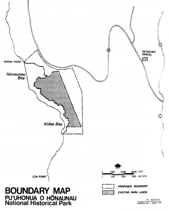

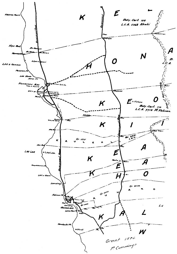
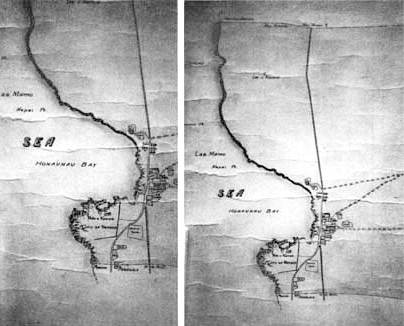
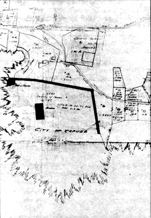
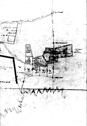
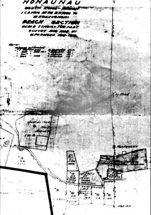
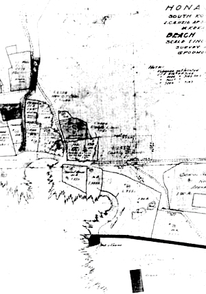
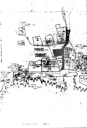
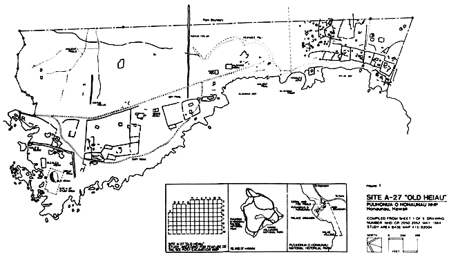
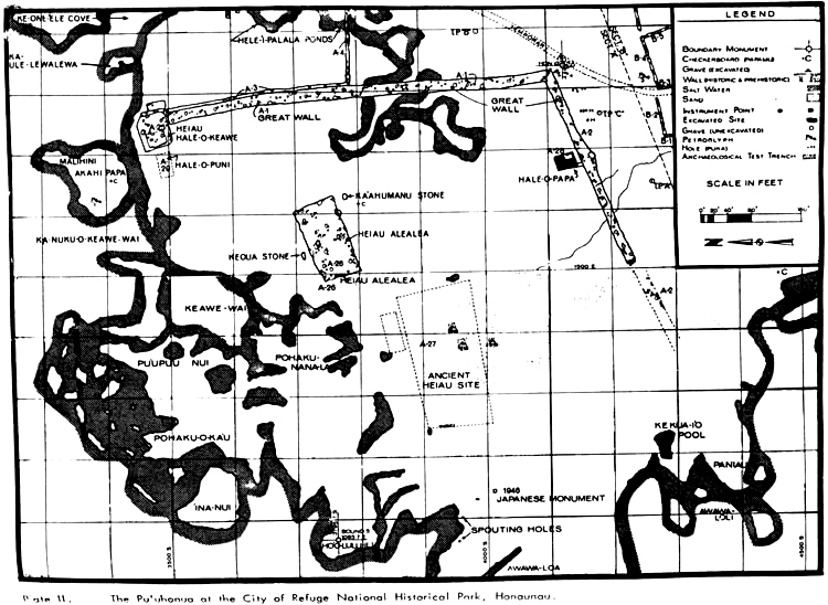
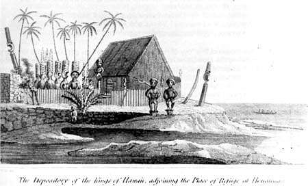
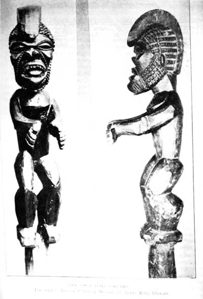
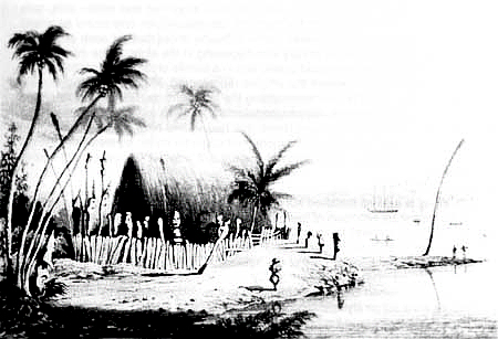
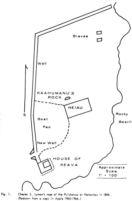
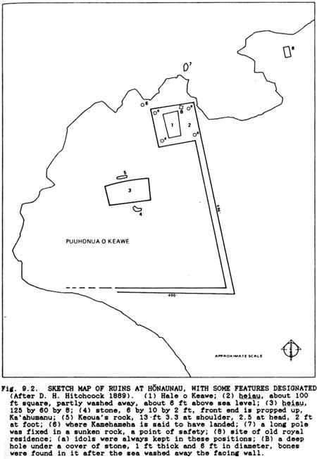
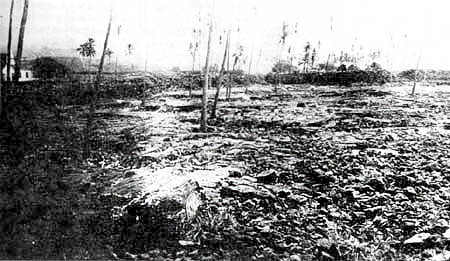
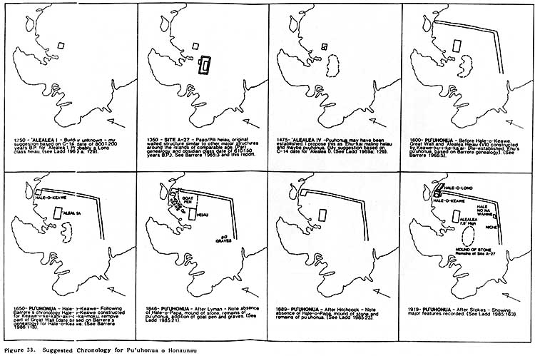
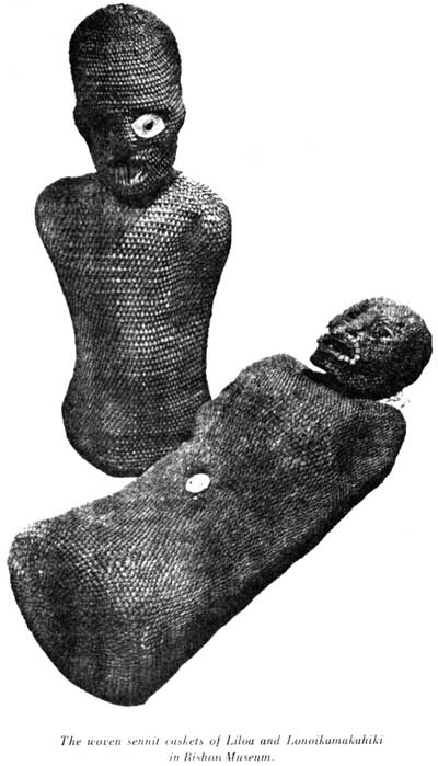
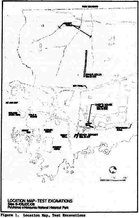
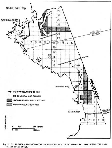
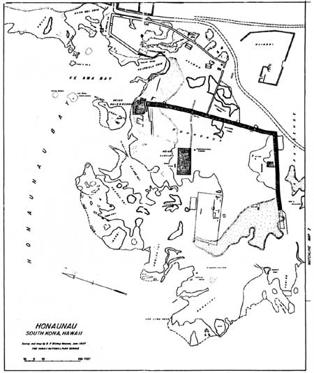
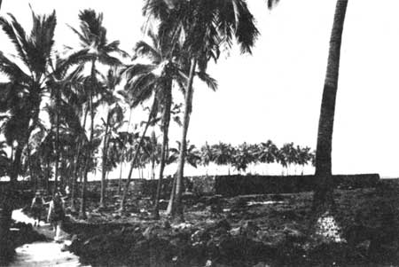
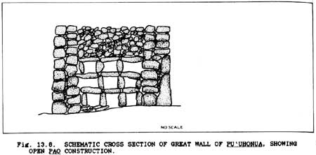
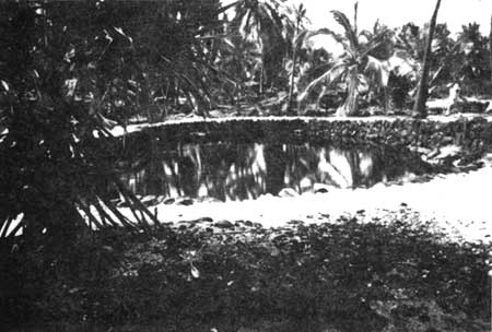
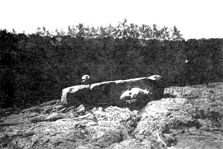
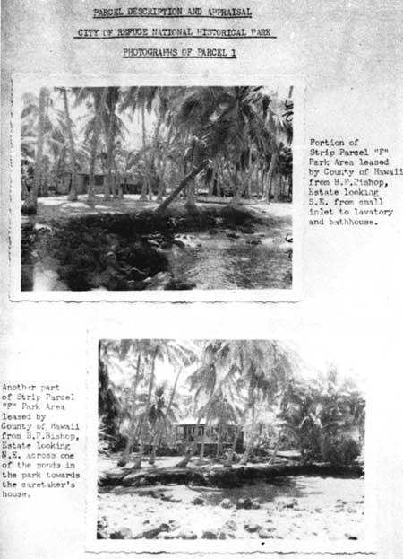
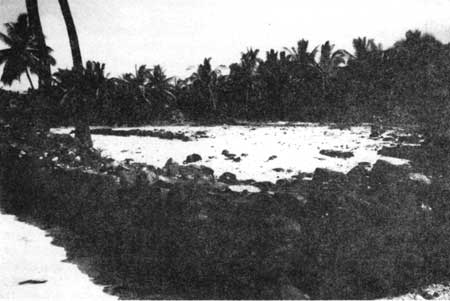
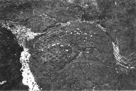
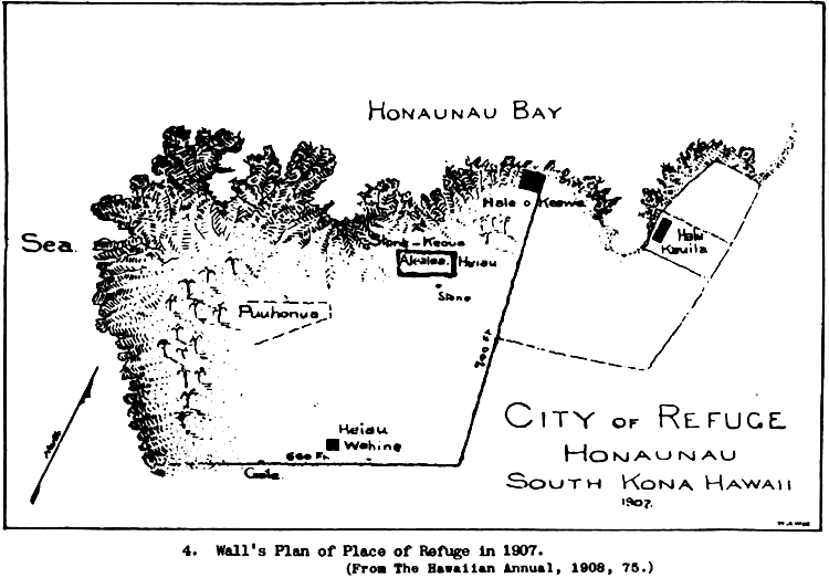
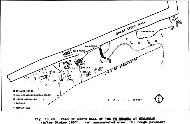
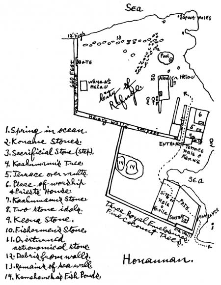
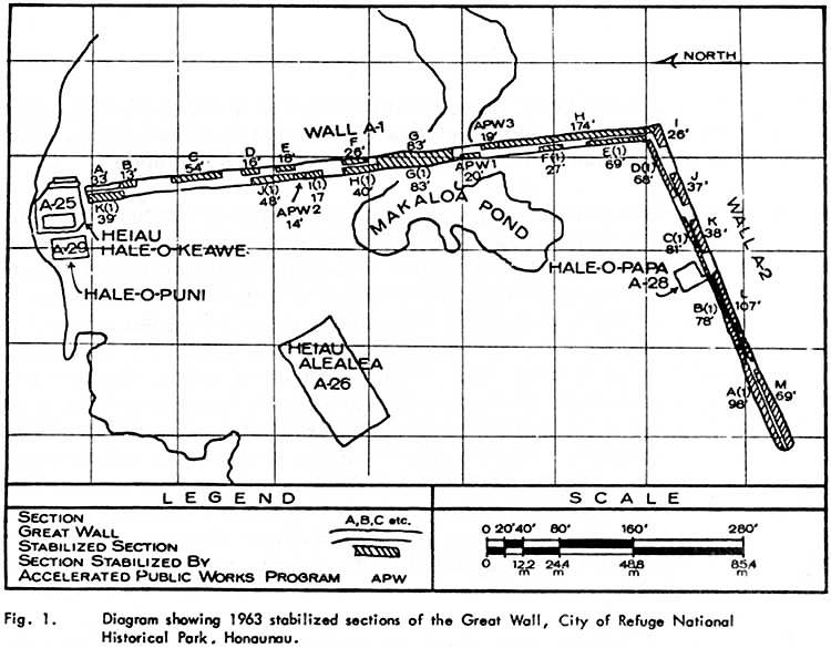
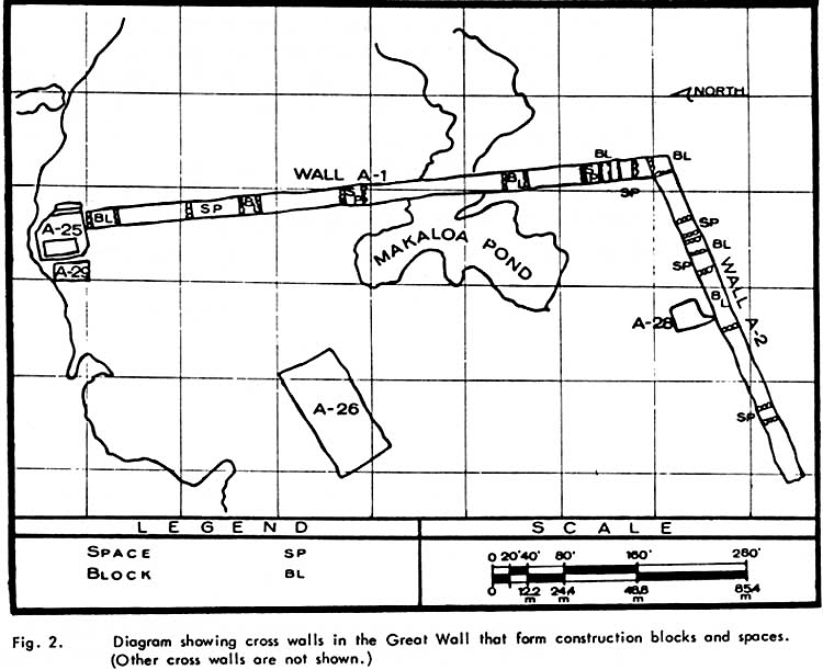
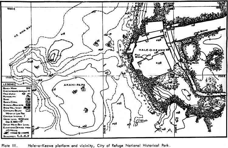
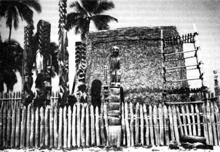
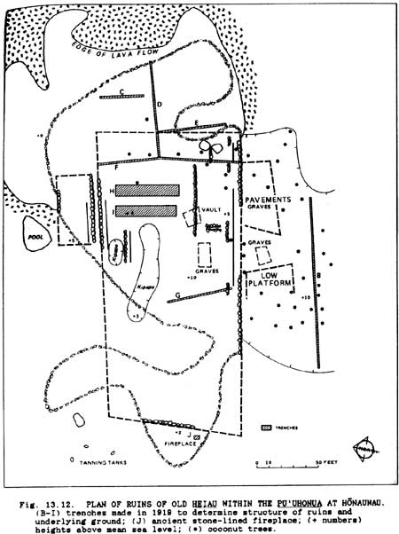
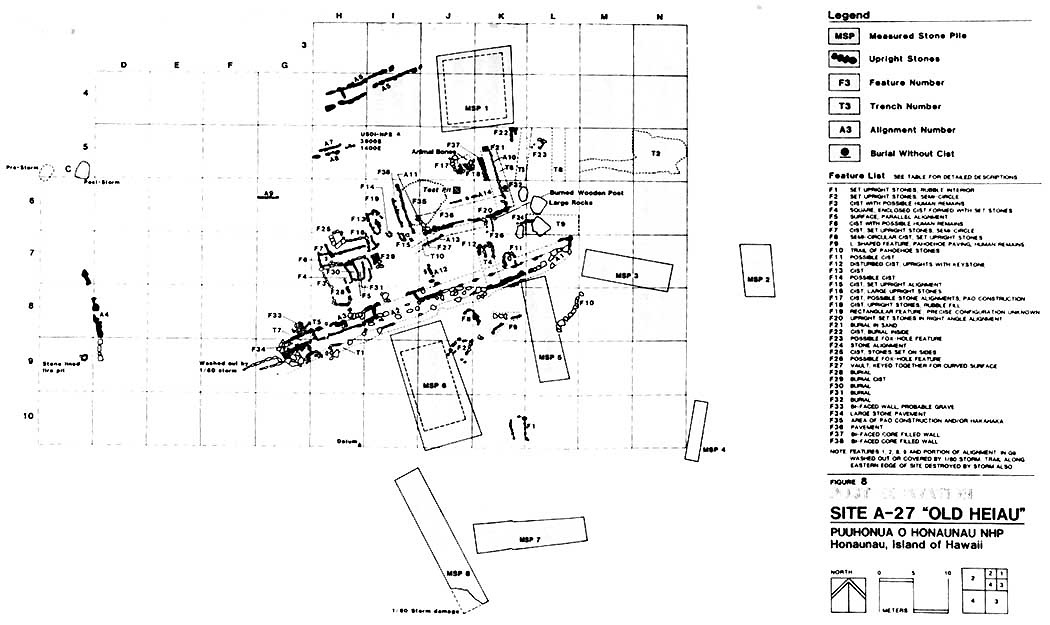
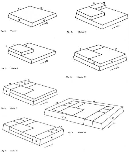
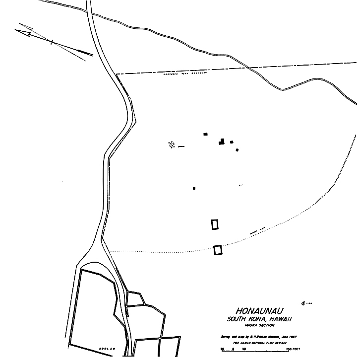
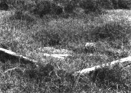
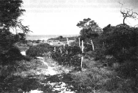
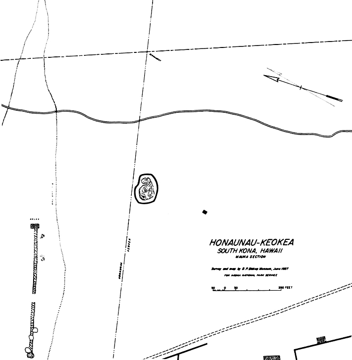
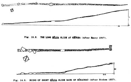
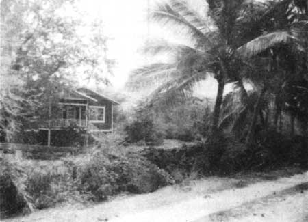
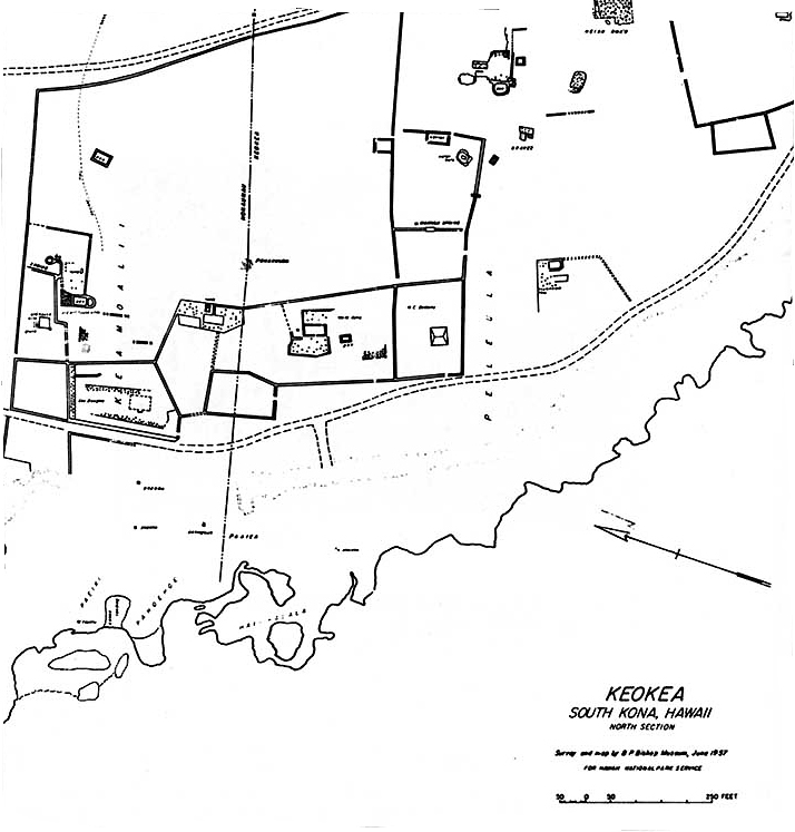
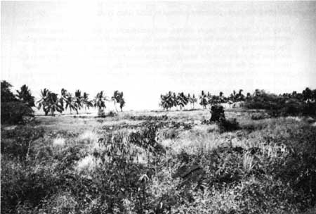
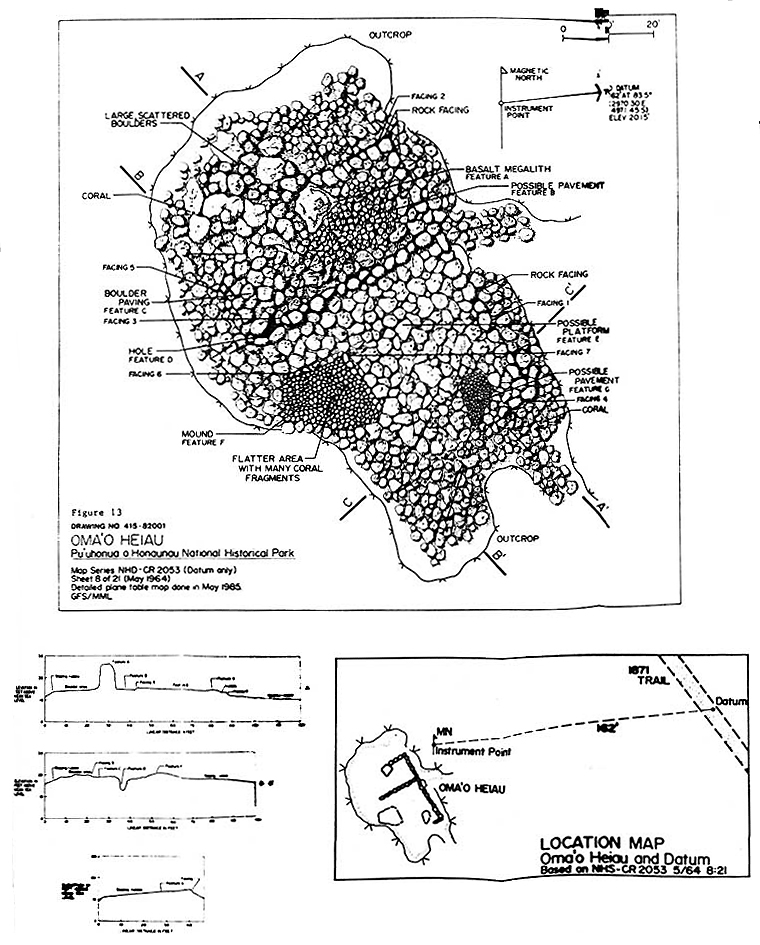
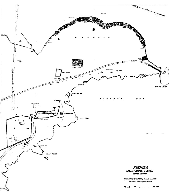
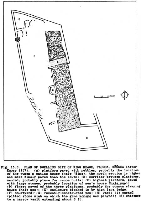
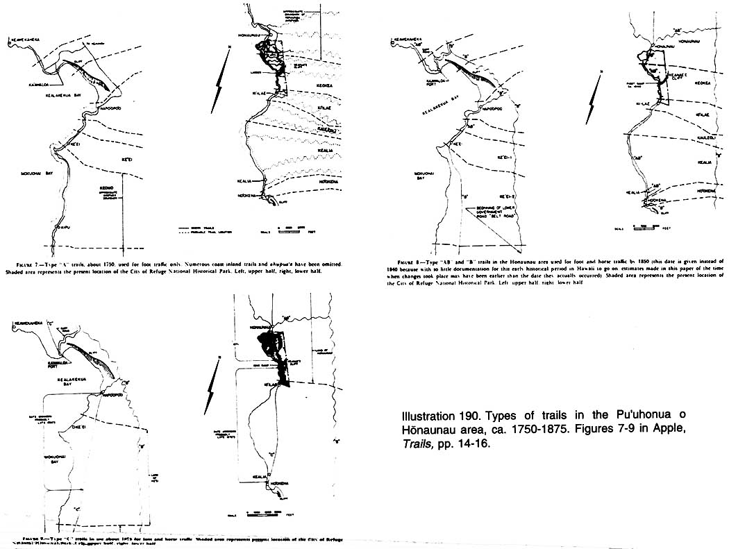
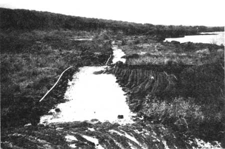
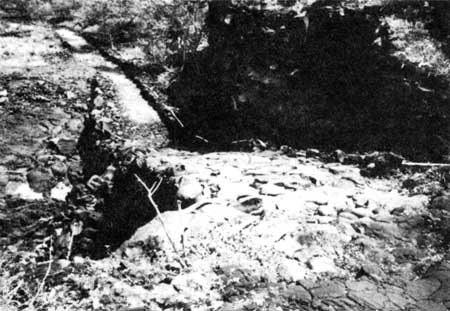
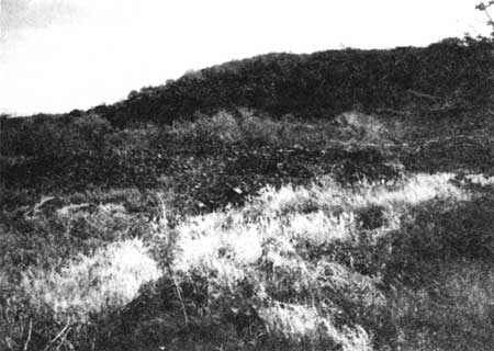
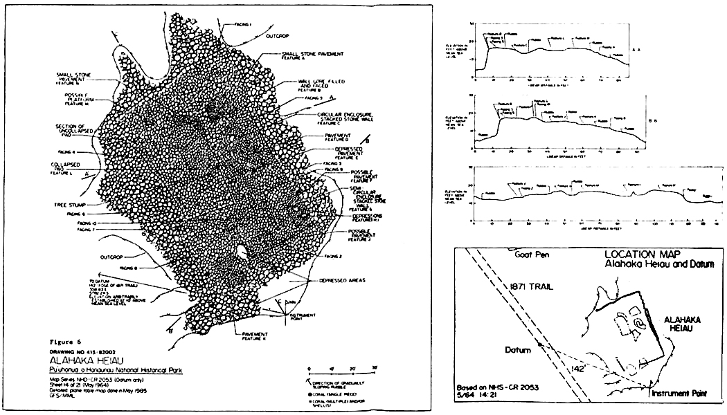
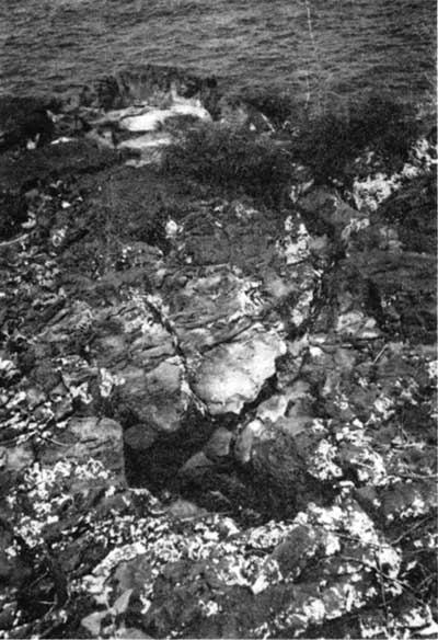
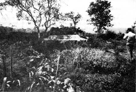
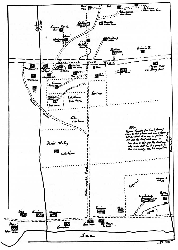
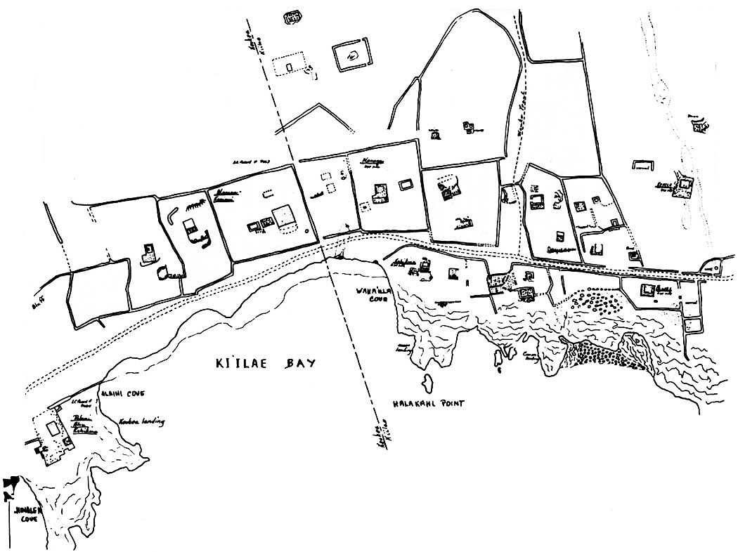
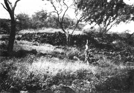
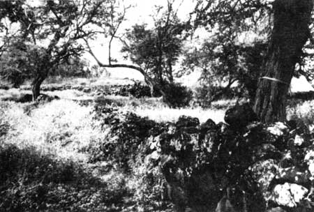
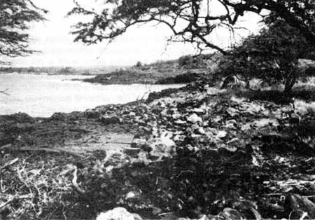
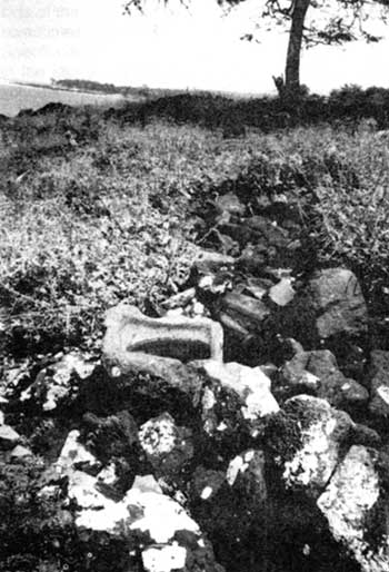
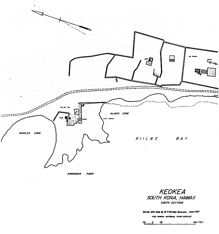
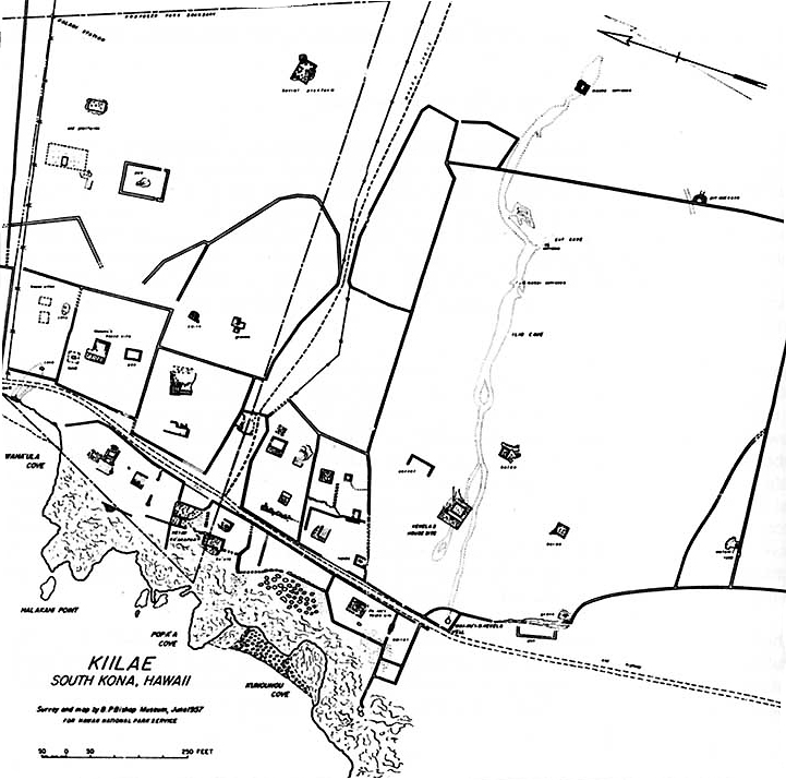
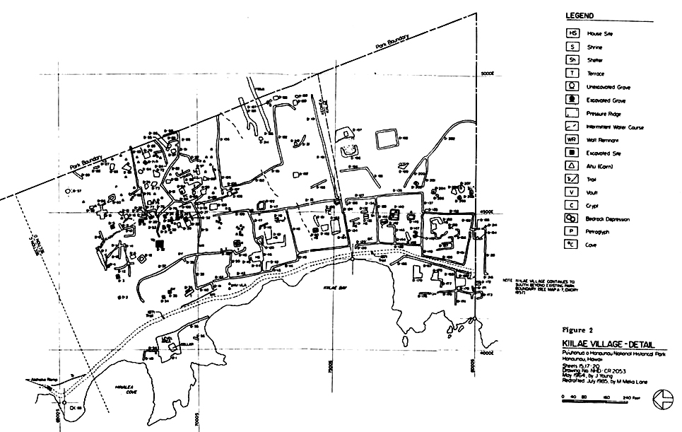
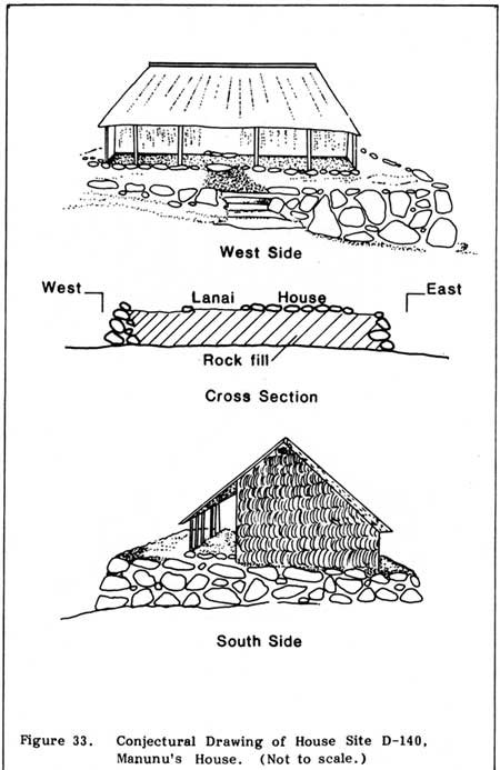
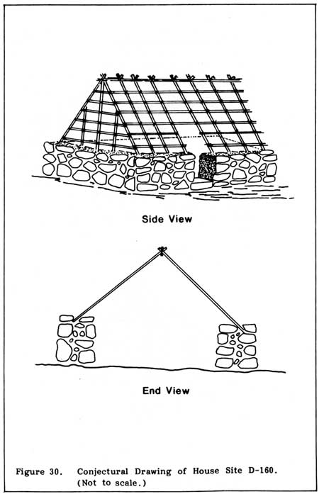
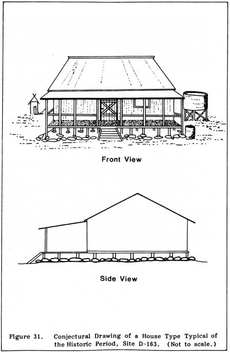
|
|
|
|
|
|
||
| History | Atlas | Culture | Language | Links |