Hawai`i and Its Volcanoes
|
Hawaii and Its Volcanoes by Charles H. Hitchcock, LL.D. of Dartmouth College EARTH SCIENCES LIBRARY, COPYRIGHT, 1909 BY THE HAWAIIAN GAZETTE Co., LTD
Preface
Molokai
PART
2: The History of the Exploration of Mauna Loa PART 4: The Hawaiian Type of Volcanic Action List of Plates
The object of this book is to describe correctly the phenomena connected with the discharges of molten lava from the two great Hawaiian volcanoes Kilauea and Mauna Loa. The greater part of the text presents the statements of visitors to their borders, descriptive of what they saw, set forth in chronological order. If there is some repetition of views, it is because the different observers came to similar conclusions. It is presumed that all the Hawaiian volcanoes throughout the archipelago have been developed in a similar manner starting at the bottom of the ocean there has been an outpouring of lava, gradually accumulating upwards. If the supply was inadequate these cones lost their vitality before reaching the surface of the water. In other cases the summits became the low coralline islands composed of the reefs aggregated by the labors of the industrious polypi. To illustrate these phases of development, Part I describes the Physiography of the Archipelago, alluding both to the original growth and the later imperfect stocking of the islands with plants and animals. It has been convenient also to state here other geological facts more or less intimately connected with this history. The high islands have been built up above the sea-level by the subaerial accumulation of basalt. When the igneous action ceased, the lengths of the subsequent periods are measured by the amount of erosion effected. If the time has been long, the canyons excavated by the running streams will be numerous and deep: if the time has been brief, the erosion produced has been correspondingly slight. Hence it is possible to speak of the "Old" and the "New" topography. Our studies especially illustrate the peculiarities of the Hawaiian type of volcanic action : mostly quiet, partly explosive, discharging the surplus material in surface flows, but more usually as a break-down into unknown interior abysses. The secret of the fluidity is found in the easy fusibility of the rock. It is hoped that this treatise will contribute materially to the solution of the Volcanic Problem. A deep-seated source of the heat seems to be required, which acts upon water, converting it into super-heated steam. Whether this moisture comes chiefly from surface streams, the ocean, or from the original interior magma of the earth is not so clear; but its effect in urging liquid material upward cannot be questioned. Our efforts are rewarded by the abundant demonstration of this upward pressure. How far this same energy will explain tectonic earthquakes and the secular elevation of large terrestrial areas is likewise a matter for further reflection. The public are indebted to the Hawaiian Gazette Company, Ltd., for its liberality in providing the means for the issuance of this volume. Eastern people are not aware of the existence, upon what are sometimes imagined to be "cannibal islands," of such an extensive plant for the speedy manufacture of pamphlets, books and newspapers, with first-class illustrations, as is maintained by this Company. While the title intimates a subject of local interest, scientists will find that the facts presented are an important factor in the discussion of world-wide igneous problems; and tourists can add their quota of observations to those recorded, for it is true that Kilauea is never precisely the same in any two successive days. The author takes this opportunity to thank the many gentlemen who have freely assisted him in the attempt to elicit correct statements and to eliminate everything that is trivial or untrustworthy. CHARLES H. HITCHCOCK; Honolulu, May 3, 1909 Back to Contents PART 1: Physiography of the Hawaiian Archipelago The Hawaiian Archipelago, "the loveliest fleet of islands anchored in any ocean," is usually described as consisting of eight high inhabited islands with a N. W., S. E. trend. The nautical charts, however, show a dozen smaller low islands and shoals situated to the northwest of the more important part of the group, over which the authority of the territorial government is now extended. The archipelago extends over twenty-five degrees of longitude, or about 1,800 miles. The following table presents their names, order, areas and extreme altitudes : Elevation of Low Islands and Reefs
Lowest of the High Islands
High Inhabited Islands
The uninhabited islands have an area estimated at six square miles, making the total of 6,460. These islands are partly those termed low and those called high. The first may be swept by the ocean waves in times of storms or may be simply reefs or shoals. Their origin may have been the same as that of the high islands which are supposed to have been igneous protrusions from the bottom of the ocean. The low islands may be capped by coral growth which commenced existence after the igneous eruptions had ceased. This archipelago may be conveniently divided into first, the low islands and shoals, secondly the high islands below 1,000 feet in altitude above the sea level, and third those that exceed 1,000 feet above the sea with their satellites. The depth of the ocean adjacent is put from 16,000 to 18,000 feet as determined by soundings. Adding to these figures the elevations of the highest volcanoes on Hawaii, we have the evidence of the existence of volcanoes 30,000 feet high. If arranged on a line, the islands of this archipelago represent a row of conical peaks from 18,000 to 30,000 feet. These cones must be very blunt, with a base of say two degrees upon each side, or four degrees for 16,000 feet altitude, which would represent an incline of about one hundred and fifteen feet to the mile. This corresponds with the existing visible slope of Mauna Loa. This slope is so gradual that one can hardly realize that the mountain is nearly 14,000 feet high, when viewed from a distance of thirty miles; and the suggestion that the steep needles or islands might be overturned by earthquakes is surely unfounded. These islands are not arranged upon a single line, and the soundings prove that other cones are scattered indiscriminately about the archipelago which do not reach the surface of the water. The submarine area adjacent to these islands must be very extensive, so much so as to suggest the existence of Tertiary strata through which the volcanoes have eaten their way. Many authors believe that Ocean islands represent the first of these volcanoes to commence eruption, followed by the rest of the first group and by the higher islands successively. Kilauea is the last because that is now an active volcano, and should another grand volcanic display be manifested in the future, it will be located to the southeast of Hawaii. This theory is probably correct in the general way; supplementary details may be suggested by the descriptions in Oahu, Maui and Hawaii. The charts published by the Hydrographic Office of the Navy Department of the most remote low islands of the Hawaiian Archipelago were prepared from observations made by the officers of the U. S. steamer Lackawanna in I867. The others have been explored by European navigators. This series is extensively used by mariners in the mid-Pacific, and the sailing directions are being constantly perfected, chiefly by the Navy Department of the United States. In 1899 the U. S. S. Nero, under the direction of Lieut. Commander H. M. Hodges, was fitted up with the necessary apparatus to take soundings, observe the temperatures and the character of the sea bottom between Honolulu and the Philippines by the way of Guam, and this was for the determination of the proper route for a telegraphic cable. I will mention the principal matters of interest ascertained along this line between Honolulu and Midway, where a cable office has been established. The route lay on the eastern side of the archipelago, a distance of 1,184 miles. Leaving Oahu the depth increased quite rapidly until it reached 2,500 fathoms, at a distance due north of thirty miles. The line led along a plain from 2,500 to 3,000 fathoms in depth, save that there were two or three outlying peaks rising half-way or more to the surface. The average temperature of the surface water was 73.2° F.; of the bottom about 35°.The pelagic deposits were chiefly Red clay, Volcanic mud and Globigerina ooze. The first is the most extensive, being a smooth, sticky mud, from light yellowish brown to dark chocolate in color, and composed of clay, calcareous and siliceous organisms, mineral fragments of volcanic origin, and various products of local chemical formation, as nodules of manganese peroxide, crystals of phillipsite and particles of palagonite. The teeth of sharks and fish were not found in this section. The least depth at which the red clay was found was 2,010 fathoms. This material is supposed to have been derived largely from the pumice blown out from volcanoes and carried over all the oceans by currents. When thoroughly soaked it sinks and changes its color. The volcanic mud consists of pumice, glass, ashes and the debris of volcanic rocks, more or less mixed with organisms at great depths. It has been derived from the volcanic masses of the several islands adjacent, and thus passes into the terrigenous deposits. The most abundant constituent is the glass, occurring as threads, masses from which the fibres were drawn out and angular transparent fragments. Red palagonite is more common in this than in any other pelagic deposit. The Globigerina ooze contains over 30 per cent, of calcium carbonate in the form of minute shells of foraminifera, of which the most common is that from which the name is given. The animals swarm in the waters above 2,200 fathoms and the dead shells accumulate at the bottom of the sea. When alive the surface of the sphere is covered by numerous spines suggestive of chestnut burrs, except that they are of very uneven lengths. When this ooze is Brought to the surface and is solidified, it becomes chalk.No one can satisfactorily estimate the thickness of these pelagic deposits. They must have been accumulating for several geological periods. Because of the presence of large amounts of calcium carbonate in the ocean of organic origin, the water has dissolved as much of that mineral as it will carry and also abounds in carbonic acid, which assists in dissolving other substances than ' calcium. Certain other deposits common in other parts of the ocean as the Diatom and Radiolarian oozes and the Blue and Green muds are wanting in the materials brought up from the bottom along the line between Honolulu and Midway. Back to ContentsThe Low Islands The Ocean Islands are the most remote of the group, touching longitude 178 30', being very nearly the antipodes of Greenwich. It is a small sandy area about one mile square inside of and nearly touching the coralline rim of about sixteen miles circuit. On the west side there is a gap of a mile, but the water is too shallow at the entrance and the interior to permit of the ingress of seagoing vessels. The area must be about thirty-eight square miles. Another name is Cure; also the inside island is called Green. The shrubbery is better developed than upon Midway. There are also inconspicuous bare, sandy islands in the lagoon, ten feet in height. Upon the "Sand Island" the Lackawanna party found the trunk and roots of a large tree, probably coniferous, drifted from the American continent. Both Ocean and Midway Islands afford convenient conditions for the establishment of rookeries by numerous albatross, tropic birds, man-of-war, hawks and gulls, and a few curlew and plover. Turtle, seal and fish also abounded.The Midway Islands closely resemble the Ocean. There are the same two kinds, the one shrubby and the other sandy, with a larger coralline rim. Originally they were called Brooks Islands, from their discoverer, Captain N. C. Brooks of the Hawaiian bark Gambia, in 1859. The coral rim is eighteen miles in circuit, with a gap of four miles upon the west side, where several breakers remain. The rim is a compact coral wall, five feet high, and from six to twenty feet in width. The entrance to the harbor is about a mile wide, with a depth of three fathoms. To the north of the two islands is a lagoon from four to eight fathoms in depth, connected with the harbor by shallow water a mile wide. The total area of the atoll is about forty square miles. The most important feature is the presence of two islands within the rim, named Sand and Eastern. The one composed of sand adjoins the harbor, one and a half miles long, three-quarters of a mile wide, chiefly composed of broken coral, shells and sand, and reaches an altitude of fifty-seven feet. Occasional clumps of shrubs and a few patches of grass were to be seen at the first, but must now have partly disappeared since its occupation as a cable station. The other island nearly touches the outer rim, is one and a quarter miles long, one-half mile wide, of uniform elevation from six to fifteen feet, covered with small shrubs, a few vines and coarse grass. The beach is of dazzling brightness. Water is found at the depth of four to seven feet upon both islands, which is free from organic impurities, but contains enough lime to place it in the category of "hard water," besides more than the average content of salt than is seen upon the upland. Considerable labor has been expended in the erection of the buildings necessary for a cable station and the improvement of the harbor. It was first occupied for this purpose in 1902.
There are four or five main buildings of reinforced concrete consisting of the plant necessary for the cable service, the house of the superintendent, the quarters for the staff, apartments for general use, and buildings for employees. Everything necessary for the comfort of the men living in such an isolated locality is abundantly supplied by the Cable Company. The large ring is a typical coral atoll with a harbor upon the west side and deeper water in the central part than near the outside. Except the larger Sand Island the other islets may be swept by the ocean when the unusual storms prevail. In 1885 a sixty ton schooner, Captain Bohn, left Yokohama in August and was driven far away from its course by storms, and reached Midway Island in November considerably damaged. There were twenty-seven persons aboard, and they remained here till March 8, 1886, the island furnishing plenty of food, as was said, enough for a three years cruise. The drifted logs must have furnished material for the needed repairs to the schooner. The seen upon the islands as six to eight millions, of which the terns are the most numerous, followed by the albatross, two millions. It is the breeding place of these creatures, a rookery. Allowing half a pound of fish for food to each albatross, they must consume five hundred tons daily. The eggs are laid in late January or early February, and the young are equipped with adult plumage and ability to take long flight by the end of September. For ten months of the year these birds live at Laysan, not wandering far from their breeding ground. "Much of interest could be said concerning the guano deposits and the operations of the company that lease the island. Thousands of tons are exported annually, and it is entirely possible that this valuable fertilizer is now being deposited as rapidly as ever it was, owing to the wise policy of not disturbing the birds that is rigidly enforced by the company. The excrement is almost entirely fluid, and gradually saturates and fills the thin soil and porous coral rock, thus making the 'guano' of commerce. Strangely enough, there is no very perceptible odor, even at the rookery."The naturalists of the Albatross spent a week in studying the fauna and flora of this exceedingly interesting island, while the naval officers made a complete map, including a chart of the reefs near the anchorage. Here are found unexcelled conditions for collecting and studying the life histories of birds. All the species are very abundant and can be seen in a day's visit. Every species can be caught, either in the hand or with a hand net, and mercifully killed with chloroform without mutilation or blood stains. They can all be studied at leisure, and at close range. The photographer finds himself in a veritable paradise, able to set up his camera at any desirable distance, even to 'pose' his subjects to suit his fancy, and take pictures of birds' nests and young to his heart's content.
"It is simply delightful to find one spot at least in this world of ours where the birds are not afraid. So long as the guano holds out those conditions will probably remain unchanged. If this time comes to an end, the Government should see to it that this wonderful preserve of avian life is protected from the ravages of man, the destroyer, and of the rapidly iminishing moiety of his better half that still persists in the aboriginal feather-wearing habit." Thousands of eggs are gathered here from time to time which are used in the manufacture of albumen. One of the closing acts of President Roosevelt's administration was the setting apart of eight islands of the archipelago as a reservation for the protection of the native birds, as here shown:
The Lowest of the High Islands Gardiner Island is a cone one hundred and seventy feet high, and one and a half miles in diameter. At the base there is a cliff encircling the island, sixty or seventy feet high, made by the dashing of the waves against the rock. On the east side there is an additional small mass of land. French Frigate Shoal is shaped somewhat like one's boot. There are five sand spits, always dry, near the northern end. The, enclosed area is full of rocks and banks mostly submerged and separated by deep holes. The largest islet is a basaltic rock one hundred and twenty feet high, and is situated on the inside of the reef less than three miles distant. The area of the shoal is from twenty-five to thirty square miles. The water is seventy-two feet deep a short distance away from the rock.
The Maro Reef is of quadrangular shape about twenty-two and five-tenths square miles in extent. There is nothing visible but breakers, which are very low and the reef is a most dangerous one for the mariner to encounter. Necker Island has much the same shape as the French Frigate Shoal. The highest peak is three hundred feet high. The island is seven-tenths of a mile long, bounded by the usual cliff made by the waves. The widest part is five hundred feet. The top is undulating, with some soil. There seems to be a landing place on the inner angle of the foot. Quite an extensive shoal surrounds the island, represented by one authority as being principally upon the south side. Necker Island is surrounded by shallow water, eighty-four feet deep at the distance of one mile from the shore. Back to ContentsNihoa or Bird Island Our information about this island is derived from two reports made by Dr. S. E. Bishop in connection with a large excursion party from Honolulu, July 20-22, 1885. The Princess Liliuokalani, afterwards the Queen, took the direction of affairs. The party numbered between two and three hundred people, including Dr. Bishop as surveyor and geologist, Hon. S. B. Dole ornithologist, James Williams photographer. Landing was effected with some difficulty and because the sea rose during the forenoon it was less easy to reembark in the small boats carrying the people and their effects to the steamer. The island was densely crowded with the nests of birds estimated to be 2,500 to the acre, which would make half a million nests and twice as many birds. Being disturbed by the visitors, the adult birds rose in enormous clouds, leaving their eggs and young, usually a single one in each nest. Surveying was carried on industriously till all at once a fire broke out, and because the surface was covered with dry grass and twigs a dense smoke arose rendering it impossible to take observations, and everybody scrambled back to the steamer. The island is very like the rocks in other regions which furnish guano, and doubtless is capable of furnishing a considerable amount of fertilizing materials. Though his observations were interrupted by the fire, Dr. Bishop has described succinctly the main features of the geology and topography. He says : "The extreme length of Nihoa from W.N.W. to E.S.E. is not far from 5,200 feet. Its average width is about 2,000 feet, giving an area of about two hundred and fifty acres. Four-fifths of this is a very steep grassy slope, the rest precipices. I did not see enough level ground to build a native hut upon without terracing. The general contours are much like those of Punchbowl towards Waikiki, save that the ridges tend inward instead of radiating outward." The N.E. pinnacle, which overhangs, is eight hundred and sixty-nine feet high; the higher N.W. pinnacle is nine hundred feet; both subject to correction for from ten to twenty feet. As to the geology, Nihoa is the small remaining portion of an extremely eroded and deeply submerged volcanic dome homologous with the larger islands which still survive in their various stages of present upbuilding, recent extinction of volcanic activity, less or more advanced erosion, and slighter or deeper subsidence. Nihoa was probably a more ancient crater than Kauai. It seems to be a pair of clinkery pinnacles out of the inner core of a once mighty dome which has been eaten down by winds and rains for thousands of feet and during unreckoned ages. Several parallel basaltic dikes cut the island from end to end and from summit to base, perhaps forty or fifty in number. Dr. Bishop infers from the great number of these dikes a very protracted period of igneous activity. The island may have been like Oahu or Maui originally, losing its substance partly by erosion and partly by submergence till only a small remnant is left. Back to ContentsThe High Inhabited Islands The first of the inhabited islands met with in proceeding southeasterly is Niihau, fifteen miles west of Kauai. It is eighteen miles long, eight miles in its widest part, and has an area of ninety-seven square miles. There seems to be a central high portion called Kaeo and a lower plain on three sides. The higher part is irregular, destitute of sharp peaks and narrow ridges. The side towards Kauai is precipitous. About two-thirds of the island is comparatively low, of coral origin, and is the region that is inhabited. The little island has had a rather romantic history. It has now been owned for forty years past by Mr. George S. Gay. The family includes Mr. and Mrs. Gay and several children, who except for an occasional guest, seldom saw any of their own race previous to our occupancy of the group. Mr. Gay made a comfortable fortune on the island, of which he was the sole owner. The island is a great sheep ranch, embracing about 70,000 acres, with a native population of 178, all that remains of nearly 1,000 natives who inhabited it sixty years ago. It would seem that here, if anywhere, the conditions were favorable for the perpetuity of the native race. Mr. Gay did everything in his power to preserve the aborigines from the evils attendant upon civilization; but in spite of his efforts they have been rapidly dying out, just as their brethren in all other parts of the island group have been dwindling away. There are two small cinder cones adjacent to Niihau, Kaula upon the east and Lehtta upon the west side. The first is about the size and shape of Punchbowl cut in two, and the lower half destroyed by waves. The concentric structure of the yellow cinders, much like the surface of the lower Koko Head, is very obvious. Lehua proves to be a similar remnant, less eroded, as it has maintained about two hundred degrees of its circumference instead of the one hundred and forty degrees of Kaula. Both these crater cones have the western or leeward sides the highest, because the trade winds drive the falling rain of ashes and lapilli in the direction of the air movement, building up a compact laminated pile of material to the leeward. The subsequent erosion by the waves will fashion a crescent shaped island opening to the winds and surges upon the northeast side. Back to Contents
Kauai is the "Garden Island" of the archipelago because the rocks have been disintegrated into soils more effectually than elsewhere. The relief map by W. T. Pope of the Normal School has been reduced in the photograph to about one-fifth of its original dimensions and shows well the principal physiographic features. The shape is between circular and quadrangular, over twenty-five miles in diameter, with an extension of swampy and low marine ground upon the west side. No very extensive explorations have been made, but we have the statement by Professor J. D. Dana in the Report of the United States Exploring Expedition, 1840, that the layers of basalt are thicker in the center and dip outwardly toward the sea in all directions. Waialeale is the highest point in the island, 5,250 feet, obtusely pointed, covered by bogs, wet most of the time and very rarely visited, certainly by no scientific person, so far as the records go. The principal streams start from near the summit : three of them entering Hanalei Bay upon the north, one flowing on the east through Lihue, two to the south. The McBryde Sugar Plantation derives power for its operations from an artificial waterfall upon the Wainiha stream only one and a half miles from Hanalei Bay. The water is taken from the stream at an elevation of seven hundred feet, is carried in a ditch for four and one-half miles, and falls five hundred and sixty-five feet to the wheels. The power is conveyed by a pole-line for thirty-four miles over rough mountain ranges considerably to the east of the Wainiha to the mill. Hanalei Bay upon the north shore seems to be a drowned valley, as the intervale extends miles up the stream, like the broad low plains near the mouths of large streams in more northern latitudes. On the opposite shore is the Hanapepe valley entering a bay in a similar manner, and is spoken of as one of the most extensive and beautiful upon the island. Nawilili Bay upon the southeast is the principal landing place for visitors from Oahu, and it seems to skirt the edge of a plateau two hundred or three hundred feet high. The Wailua River has a noted cataract upon it two and a half miles from the sea. The smaller streams are generally nearly closed by bars of coral sand. The distinction between the windward and leeward sides is very plain, as made known by the erosion. It is emphasized upon the Government map by the primary division into the two districts of Puna and Kona. Lihue, Kawaihau and Hanalei show a greater amount of denudation than the slopes of Waimea, and in this last region the contrast in the amount of excavation is very great between the two sides of the Waimea River, the west side being a cliff and the east a gradual slope from the dividing range seven or eight miles distant. There must be a small wind-gap where the road from Hanalei passes over the divide to the Waimea, whose altitude is 4,525 feet and bears the name of Kilohana. Sugar plantations adjoin the coast on every side except the northwest,Napali, where cliffs from one to two thousand feet high constitute the shore line. Between Nawilili and Anahola Bays there is an extensive plain from two hundred to three hundred feet high cut down through soft material forming canyons for the rivers. The earlier authors ascribed this material to the decay of the basalts, which came from ancient volcanoes in the interior. Many of the layers seem to be the result of decay, as they are filled with the concentric boulderlike masses somewhat related to the columnar structure; but interbedded with them are layers of earth better comparable with volcanic ashes which may also cover the surface. It is not strange that ashes should present the slight inclinations of from one to five degrees commonly noted here. The relief map shows in Lihue one large volcanic cone, Kilohana, nearly a mile in diameter, and other smaller ones. Why have not those plains been made up of the ejections from the several secondary volcanoes, like alluvial fans, rather than from the older ones discharging lava? The prevalence of volcanic ashes has been proved for the active and extinct vents in Hawaii and Oahu, and should surely be looked for upon any of the other islands. Their recency would seem to be proved by the steep walls of the canyons in the loose materials. There would therefore seem to be two classes of volcanic discharges in Kauai, first the underlying basalts making up the great dome of Waialaele, and second many secondary craters, situated upon the flanks and eroded basins of the earlier lavas, and representing an inferior degree of activity. Crossing the Wailua River is a ridge several hundred feet high less than a mile back from the shore, rising abruptly above the plain. This would naturally represent one of the older lavas. Back of Anahola a similar wall is pointed out, where a hole has been worn through the hill. Professor Dana suggests the possibility of the presence of a second principal dome to account for the greater elevation of the land in Napali on the shore opposite to Niihau. The two islands have cliffs in a line with each other. If we could imagine some volcanic disturbance of a late date that should fracture the ledges, we could readily understand how the debris should have disappeared later by the action of the waves. Granting the presence of a dome between the islands the structure would simulate that of Oahu and Maui where two eruptive mountains have been connected by necks of later-formed material. In Koloa there are several secondary volcanic cones in an area of eight or ten square miles. The lavas are black with the peculiar ropy structure and beneath are caverns, either the result of bulging or left by the streams that were protected by the congealed surface. Unlike those back of Hilo, they do not show any stalactites; but being near the sea the waves of the ocean press into the cavities and spout from orifices quite high into the air. In this neighborhood are the celebrated barking sands, as well as at Mana at the extreme western end of the island. Some of the soils are intensely red in color because the growth of the vegetation brings the iron into new combinations with organic acids. The shores of Kauai are lined with coral reefs and limestones, which are disintegrated and washed into beaches, and may be blown inland considerable distances. Some of these wind-driven sands reach altitudes of thirty-five and fifty feet and become consolidated. It is difficult to draw the line between the wind-blown sands and beaches formed by elevation of the land, both of which undoubtedly are to be found here as on Oahu. A confirmation of our belief in the greater antiquity of Kauai over the other islands is derived from the study of the plants. This is presented forcibly by Dr. William Hillebrand in his Flora of the Hawaiian Islands. Taking the extremes, it may be stated that the flora of Mauna Loa is the poorest and most uniform, and that of Kauai the richest and most individualized in species. On the whole the intervening islands follow the same ratio when allowance is made for differences and elevation. "The monotony of the forests of Puna, Kau and South Kona on Hawaii, will strike every attentive visitor and disappoint the botanical collector by the scarcity of the harvest. This can hardly be ascribed to the periodical destruction of forests by lava streams, for these follow with long intermission, affect only limited areas at a time, descend mostly down the northeast slope, and it is surprising to see how quickly the ruin is repaired, how speedily decomposition takes place in the lava when exposed to the influence of copious rains and the trade winds. In 1862 I visited the lower end of the lava stream which in 1856 had cut its way through the forests toward Hilo. A belt of thirty feet in width on each side of it was covered with a shrubby vegetation which had already attained a height of three to four feet. In the break of the pali of Oahu at the head of Nuuanu valley, through which the trade winds sweep with intense force nearly the entire year, one could observe hard compact basalt gradually softening until it could be cut with a pocket knife. And with how little soil plants are content when favored by copious rains is exemplified by the fact that the natives of Puna, Hawaii, raise good crops of sweet potatoes in the hollows and cracks of bare lava by simply covering the budding sprigs with decayed leaves and herbs. In the same region I once saw a cocoanut lying on smooth pahoehoe lava which had germinated there and sent off a root for a distance of eight inches until it met a crack down which it descended. On the other hand, the same kind of lava when not affected by rain and wind will remain unchanged for centuries, as may be seen under the lee of East Maui. Nowhere else have the forests, although extensive, so gregarious a character as within the area of Mauna Loa, and the species which comprise them show hardly any variation from those forms which are met with more to the east. The forests of Hilo and Hamakua, which belong to the region of Mauna Kea, are already more diversified, and still more those of the Kohala range. In great contrast stands the vegetation both of Kauai and of the Kaala range of Oahu. Most of Mann's and Wawra's new species come from Kauai, and Mr. Knudsen's collections have added still more to them. Even the species which that island has in common with others generally vary from them in one or more particulars. The Kauai species of the leading Hawaiian genera are in all instances the most specialized, to be distinguished by more striking characters than the others. Examples are: Schiedea, Raillardia, Dabantia, Campylotheca, Lipochaeta, Pittosporum, Pelea. The proportion of species peculiar to Kauai with species peculiar to all the other islands is about 67:382, or 17.5:100." Much may be learned from a study of the origin of the plants of the archipelago. Out of a thousand species, as described by Hillebrand, there are five hundred and forty-seven exogens, thirtyfive endogens and eighty-four vascular cryptogams,, chiefly ferns; of an exclusively Hawaiian origin, sixty-six per cent. Of the remainder there are first, many tropical species widely distributed throughout Polynesia; second, many that are allied to North American forms; third, a smaller number resembling plants in Asia and Polynesia; fourth and fifth, the smallest numbers, from Australia and Africa. The plants useful for food or fabrics have probably been introduced by the natives. They are such as the plantain, banana, coconut, breadfruit, pineapple, yam, taro, cotton, peach, fig, sugar cane, orange and alligator pear. Various weeds, mostly undesirable or noxious, particularly the lantana, have come with American immigrants. A few characteristic indigenous Hawaiian plants are the koa wood, lately called Hawaiian mahogany, the hau and milo, malvaceous species, silver sword and the ohelo, a huckleberry of the size and often color of the cranberry. Some plants become shrubs or trees, as the lobelia, violet and many Compositae. All the plants are either exotic orelse have been derived from species brought by the waves, by animals or by man. A good illustration of the origin of the vegetation is the screw pine, pandanus or lauhala. This is a small tree growing at trie sea shore. The seeds are edible and are gathered together in bunches somewhat like a small pineapple, each one being a wedge with the small part inside. These seeds will stand saturation in water for months without losing their vitality. Hence they may be carried hundreds or thousands of miles from the place of their nativity, and when washed inland by unusually high waves will be placed where they will sprout and grow up. I once saw a place in Kauai where hundreds of young lauhalas had started to grow near the sea shore just like the multitude of young maples in New England. In both cases the majority die, but some will live, and upon the islands the lauhala will be the means of the increase of dry land. There is no tree with a wider range in the Pacific than the pandanus. And it was in existence in the Triassic period in Europe. It is therefore one of the oldest and most persistent of plants, and the one best fitted to start plant life upon the isolated volcanic islands for the first time peering above the waters. The accepted doctrine for the covering of the islands of the Pacific with vegetation is not that they were specially created where now found, nor that they are tips of a submerged continent, but that the barren rocks attracted the seeds brought by ocean currents from all sides, and that when the plants in the new region found the conditions favorable for a luxuriant growth they flourished exuberantly and developed into the new species said to be indigenous. And the various examples just cited prove that there is a constant development both of vegetable and animal life in the new habitats. Oahu has been celebrated for the abundance of the peculiar land shells known as Achatinellidae or agate shells living naturally upon it. There are over two hundred species of them, represented by 800 or 1,000 varieties, and each of these, forms is confined to a small section of territory in the forests of the two ranges of mountains. Each valley has its own peculiar varieties. The most widely divergent forms of one group will be found in the valleys that are most distant from each other, while intermediate varieties will be found in the intermediate valleys. The species living far apart cannot be connected by minute gradations without bringing in some of the forms found in the intermediate territory. Granting that these organisms are all descended from one original stock, the diversity at present existing has been supposed to be produced by exposure to different environments, cooperating with a series of isolations; and if the diversities have been systematically developed it must be possible to locate the home of the original species and the routes of their migrations. It will be interesting also to discover whether some one of the islands carried the original animal, whose descendants migrated to other parts of the archipelago, and whether the developments have corresponded to the geological ages of the different areas. While no one has yet succeeded in discovering the order of development, there is a suggestion that the ancestor of the Oahu forms came from Kauai and it is a fact that these creatures are very scarce upon Hawaii. This order would correspond to that already mentioned about the plants, and so far forth both are in agreement with the geological conclusions. Back to Contents
The geology of Oahu has been set forth quite fully in two papers by the author in the Bulletin of the Geological Society of America, 1900 and 1906, The Geology of Oahu, and Diamond Head. The annexed photograph of the relief map, Plate 6, shows admirably the general features of the topography, two parallel ranges of mountains separated by an intervening valley and both the elevated lines considerably eroded by streams of running water. The range on the southwest side is called Kaala or Waianae, culminating at 4,030 feet, with a dozen separate peaks, and the deepest part is near the middle, over which a road has been built reaching the altitude of 1,590 feet. On the ocean side there are five prominent ridges dividing the general slope into six valleys, the largest of which, holding the village of Waianae, measures six miles from the crest to the sea and is about three and one-half miles wide. Each valley has been excavated by running streams, and the erosion has been greatest upon the slope facing the water, though there may be others of equally large dimensions now concealed by later flows It is evident that the Kaala area represents the original island: igneous discharges produced a dome bordered by marine strata and traversed by subsequent injections. Later the copious rains brought both by the trade wind and the Kona storms channeled out deep valleys upon both sides. This island existed for many ages before another larger volcanic mass was developed in the Koolau range, and when the uppermost igneous sheets were in motion, the corrugated eastern border of Kaala was covered by the advancing lavas. This fact was first observed by Professor J. D. Dana and is illustrated by a photograph, Plate 7, by Roger Sprague. Kaala is easily recognized by its greater height, and the plain consists of the later basalts that flowed westerly from Koolau. The view is taken from near the summit of the lowland, or the divide between Pearl City and Waialua, at Wahiawa. The plain consists of soft material rendered plastic by the decay of the originally hard basalts. The structure is obvious when one examines the sides of the canyons.
The Koolau range is divided into two parts, the more northern Koolauloa fifteen miles long, and the more southern Koolaupoko twenty-two miles long. The most pronounced ravines on the west side are upon Koolaupoko. At first, because of the lack of information, it was supposed that ravines were rare in the northern section, but Plate 6 shows that valleys are well developed all along the western slope. The highest of the Koolauloa peaks reaches 2,360 feet. Koolaupoko has several peaks that are higher. Beginning at the north end is one not named, 2,800 feet, at the head of Halawa valley. Lanihuli on the north side of the only road crossing the range at the Pali is 2,778 feet, and Konahuanui on the south side is 3,108 feet. Farther southeast the crest of the mountains runs more easterly, terminating in a cliff six hundred and forty-two feet high at Makapuu point. The eastern slope has been greatly eroded by the rains connected with the trade winds. Two subordinate ridges enclose Kaneohe Bay, the more northern, Kualoa, being opposite the meeting of Koolauloa and Koolaupoko, and the more southern extending from Konahuanui to Kaneohe point. The greater size of this valley seems to be due to a concentration of the erosive agencies, seen also in the excavation of the wind gap pali 1,207 feet, and the nearest approach to it of a second gap at Kalihi perhaps 200 feet higher. A third gap is in the Koukonahua gulch leading up from Wahiawa. Olamano is an isolated peak, needle-shaped, 1,693 feet, practically inaccessible. It is a relic of the former general slope to the sea from Konahuanui. At the Pali is a cliff about a thousand feet high, celebrated in history as the scene of a catastrophe, when a victorious army forced its adversary to fall over the steep slope and lose their lives. The word pali is Hawaiian for a precipice. When viewed from the east the precipice at the Pali is seen to be corrugated like the ribs of a domestic washboard. Plate 8 represents a corresponding cliff on the west side of Kaala. The visible part of the cliff must be about 2,000 feet high, and at its base is situated the plantation of the Makala Coffee Company. Like the related steep escarpment of the Arizona province the recession is precipitous, but here there are added numerous valleys rendering the whole surface corrugated. The deeply eroded flanks of Koolauloa and Koolaupoko finely illustrate the modern doctrines of subaerial erosion. Back to Contents
Within these two mountainous areas, the foundation rock everywhere is basalt, disposed in layers dipping quaquaversally from the central lines. Kaala was an elliptic, Koolau an elongated dome, each with its seaward sides sharply incised by canyons, and both joined together by a later formed plateau, sloping both northerly and southerly. Dana calls Oahu a "volcanic doublet," the united work of two great volcanoes which have been so greatly eroded that the proper position of their craters is now conjectural. This view is confirmed by a comparison with the Island of Maui, where one of the volcanic masses has suffered but slightly from erosion and the connecting plain is nearly at the sea level. Assuming that there were originally two volcanic domes, with layers dipping outwardly some five degrees, it remains to apply the principles of geomorphy to explain their present forms and their relative ages. These principles were admirably set forth by Professor Dana in his report on the origin of the valleys and ridges of the Pacific islands. They have been applied later to Oahu, more especially by Captain C. E. Dutton. In the volcanic islands of the Pacific the original form of the land was that of a dome, consisting of basaltic layers of variable hardness, whether solid, vesicular, or agglomeratic, and sloping gently outward in all directions. An abundant rainfall is assured by the contact of the moist air of the trade winds with the elevated mass of land. The resultant streams wear out canyons radiating from the centers or branching from axial lines of elevation. Of the two erosive forces, disintegration and transportation, the latter is the most effective in these volcanic layers, which appear almost like the strata of sediments. In case the rainfall is unequally distributed on the flanks of the elevation, the amount of erosion will vary, as may be seen in the number, shapes, and depths of the valleys excavated. Because the transporting power of water is greater where the slopes are steep, the valleys, become larger in their upper reaches, portions of the dividing ridges disappear and amphitheaters result; outliers shape themselves out of the original plateau and at the confluence of tributaries; the spaces between the streams narrow to knife edges or may disappear; the walls, originally vertical, change to slopes through the separation of blocks by gravity, which form a talus at the bases of the cliffs. Although frost is absent, so easily are the fragments separated because of the character of the rocks that the excavation is as effective as in colder climates on the more durable ledges. In the lower reaches the streams take winding curves, and thus act laterally against the sides, widening the bases. The Koolau area is the easiest on Oahu to understand. From the details already presented it is seen to be elliptical, nearly forty miles long, and deeply eroded along its seaward face, with many amphitheaters, outliers, and especially the long cliff opposite Kaneohe Bay. There has been great excavation along the western side of Koolaupoko, but comparatively little on the interior side of Koolauloa. Judging from incomplete observations on the rainfall for the past five years, the average has been one hundred and forty-four inches two miles below the Pali (Luakaha), and about twenty inches near the wharves of Honolulu; but the rainfall is confessedly greater at the crest of the ridge, probably two hundred inches, and it diminishes gradually all the way to the harbor. The fall along the eastern shoreline exceeds thirty inches, increasing to the summit; hence it appears the water should be most abundant along the crest of the range, but greater on the eastern than the western slope, and whatever the fall may be on the Honolulu side it came from the northeast. The erosion has been the greatest on the northeastern side, as seen in the Pali, the outliers, sometimes 2,000 feet high, the ridges running northeasterly, and the amphitheaters. It reached probably to the central axial line of elevation opposite Kaneohe Bay. The cliff can not very well have been eroded by the sea, since there are irregular ridges and chains of hills at intervals of two or three miles stretching out perpendicularly from the wall and ending in promontories. Marine action would have removed these projections. The erosion seems to have been most intense at the road crossing the Pali, since there is a gap worn down to 1,207 feet from about 3,000 feet on either side, and there are two other gaps to the north not far away. Some have explained the presence of the Pali gap and the horseshoe form of the land from Mokapu point to Konahuanui and thence along the main range to the northeast branch, ending at Kualoa point, by assuming a break or fault at the Pali gap or the existence of an enormous crater in the part of the circular ridge just delineated. The bestargument in reply to both these volcanic theories is that the topography is in better agreement with what is known elsewhere to be the result of subaerial erosion. If there were one transverse fault, there must have been three, quite close together, for the first cataclysmic theory; and the theory of the large crater assumes that certain cinder cones and scoria were intimately connected with it, which seems to have been formed in a different way and in later periods. On the leeward side of Koolaupoko notice has already been taken of about twenty canyons in as many miles. This is where the island is narrow and the rainfall is ample for the work accomplished, though the erosion has been less than on the windward side. Relatively little work has been done farther to the northwest, all the way to Waialua and Waimea. A part of this lack of erosion may be due to a smaller rainfall, stated to have found its maximum at the Pali gap. Certainly erosion has not proceeded for enough to excavate gorges high up, nor amphitheaters. The shallow canyons on the north shore and in Ewa are certainly suggestive of a very scant or recent action. From any hill like Punchbowl or Leilono one can see a fine long stretch of this sloping plateau, which has been utilized for the growth of sugar cane. The Kaala dome presents phenomena of erosion very similar to those of Koolau, but the greater excavations have been effected on the west side, as evidenced by the valleys of Waianae, Makaha, etc., while the gradual slopes of the Koolau area impinge closely on the latter, and the later drainage has been forced westerly. The work accomplished has been on all sides, whereas the trade winds now blow from the northeast for nine months of the year. The Kaala dome existed before the Koolau mountains were raised very much above sea level. The ocean came perhaps half way across the island, and the trade winds impinged against the basaltic piles, dropping moisture, which excavated the eastern side very completely, together with the Waianae wind gap. Two or more lengthy ridges have been mentioned as protruding easterly from Kaalaa. In later times Koolau came up from the depths and poured over the skeleton ridges on the east side of Kaala, so as to conceal them from view, and underlaid the plateau with nearly horizontal sheets of basalt. This view does not compel us to believe in the existence of climatic conditions different from those now prevailing, and it enables us to interpret what has happened from the varied topography. The greater excavations on the Waianae side have been effected by the Kona storms, both early and late. This theory is confirmed by observing a more decided contrast on the adjacent double island of Maui. The smaller, older mass of Eeka, in West Maui, has suffered much greater erosion than Kaala, and has also its wind gap, while the gigantic Haleakala, which has poured out sheets of lava almost in historic times, presents only the modern type of canyon erosion on its windward side, and the leeward side has not been affected. The contrast between the two parts of Maui is more marked than upon Oahu, but it is the same in kind and may illustrate the similar sequence of Kaala and Koolau. Back to ContentsThe Artesian Water Supply Among the interesting physical features of Oahu is the abundant water supply derived from artesian wells. All other islands possessing a similar structure are capable of yielding similar returns to effort; so it may be well to present the history of the operations by which great benefits have been derived. The need of a bountiful supply of water vitally concerns household and agricultural affairs. The numerous sugar plantations need very much water for irrigating the land. These were at first located upon the other islands like Kauai and Maui whose numerous streams supplied the necessary liquid both for irrigation and transportation. Oahu was neglected because it is comparatively arid. Near Hilo, upon Hawaii, the rainfall amounts to one hundred and seventy-five inches annually; in East Maui to two hundred and thirty inches annually; while about Honolulu it varies from twenty-four to thirty-eight inches; at Ewa and vicinity from sixteen to forty inches, and is quite variable by years, and insufficient for the growth of the cane. At first attempts were made to supply water by irrigation. Like other cities, Honolulu receives much water from mountain streams brought by pipes for household and manufacturing purposes, as well as for the flowage of extensive tracts of rice land. The great need of water led to suggestions of an artesian supply. In 1879 James Campbell sunk the first artesian well upon the island, near the Pearl River lagoon. Water commenced to flow from the depth of two hundred and forty feet, and the auger penetrated thirty-three feet farther. The next one was sunk the following year at the mouth of Manoa Valley, where the discharge proved to be abundant from the depth of two hundred and ninety-eight feet. In the same year Judge McCully obtained a still greater supply from the depth of four hundred and eighteen feet. This last well was within the city limits, where it was easily seen by the public, who thoroughly appreciated its value. Many other persons followed the example of these pioneers, till now there are more than two hundred wells upon the five leading plantations, yielding daily over three hundred million of gallons, and there are many more within the city limits of Honolulu. Back to Contents The Artesian Conditions Oahu presents two series of diversified sheets of rock dipping gently toward the sea from: high central points; but the material is volcanic. In the early days successful artesian wells had been sunk through sedimentary strata, whence it was inferred that it would be useless to attempt borings in the so-called unstratified rocks. Many were dissuaded from such attempts by that consideration, yet any geologist would quickly observe the resemblance between these volcanic sheets and a nearly horizontal stratification. There is an alternation of hard basaltic sheets, volcanic clays, ashes, and sometimes limestones which offer the necessary condition for subterranean currents as they dip gently outwardly on all sides. The meterological conditions explain the source and spread of the waters. Rain is profusely abundant on the highlands. The trade winds, laden with moisture, drop their burdens on coming in contact with the land surfaces. The maximum rainfall is at the altitude of about 1,200 feet. The preponderance of the discharge, being upon the windward side, determines the place of the most copious streams and the more effective erosion. Hence the domes have been worn away unequally. One side may be entirely removed, and the other be scarcely affected at the surface. If the ridge is narrow at the altitude of greatest precipitation both sides will be extensively worn down. This is well shown on the Koolau upland, where the southeast end has been greatly denuded upon both sides from Mokapu point to the Pali, while to the north, at a greater height, the canyons are less conspicuous on the west side. The laying bare of the interior of the dome allows the water to sink into the pervious layers, and to flow beneath the surface towards Kaala and the southwest. Only the needful alternation of pervious and impervious strata is necessary to give rise to the subterranean streams which will send water to the surface when pierced by the artesian wells. The borings upon Oahu prove the alternation of basalt, clay, earth and limestone to the depth of several hundred feet. The principal water-bearing stratum is a very porous basalt, from three hundred to four hundred feet below the sea level by the shore. It has a hard, impervious cover, sufficiently tight to prevent the passage of water through it. The following general statements concerning the artesian conditions seem to be well established:
From all the facts available, the conclusion seems warranted that the underground waters descend to the seas from the highlands and remain free from admixture till the pressure of the ocean exceeds that of the descending stream, when a commingling of the two liquids results. When the ocean pressure becomes greater, because of excessive pumping, the brine will increase in amount. In a smaller island the ocean water will force itself inland quite conspicuously. Molokai illustrates this proposition. Our information is derived from a report of Waldemar Lindgren in the Water Supply and Irrigation Papers No. 77. The springs there are of three classes, of which only the first calls for consideration here, (i) those very near the shore, (2) those breaking forth up to the height of 2,000 feet, (3) running streams still higher. Shallow wells near the shore show the following degrees of salinity or number of grains per gallon, 238, 403, 150, 126, 109, 86, 102, 86; of deeper wells the first gave eighty-six grains at the surface and became ocean water at fifty feet. The second became ocean water at one hundred and twenty-five feet. At Naiwa there are ninety grains of salinity at seventy feet. At Kalamaula several deep wells gave one hundred and two and one hundred and four grains and pure ocean water. The American Sugar Company sank several deep wells at Kaunakakai, of which the first five had one hundred and fifty grains per gallon; others ranged from two hundred and seventy to four hundred and eighty five grains. The Risdon wells yielded seventy to seventy-nine grains per gallon. Better results appeared in nine wells sunk at Kawela, many of them showing less than fifty grains of salinity. The fresh water is contaminated up to four or five feet above the sea level. None of the underground streams can be more than eight miles in length, and many do not exceed three. It is also probable that no impervious layer protects the underground water as in Oahu. 6. There are springs of 'fresh water near the sea shore in Oahu which correspond to the artesian fountains. One is the famous Kamehameha Bath near Punahou, a second is near the railroad station at Honolulu, and a third gladdens the thirsty soul at Waialua near the Haleiwa Hotel. Another is at Niu, west ol Koko Head. It would seem that the underground water finds its way to the surface through some crevice, after the usual manner of springs, and that it is powerful enough to prevent the commingling of the ocean water with it. The theory of the subterranean stream from the summits to sea level has been further tested practically by the driving of tunnels to reach the water near its source. Thus derived the water is free from any possible saline contamination, and being delivered by means of a ditch sloping downwards, the expense of sinking artesian wells and the subsequent pumping is saved. In this way a copious daily flow has been obtained from the Waianae side of Kaala, utilized to run a dynamo, besides irrigating several plantations. A second is to be found upon the Oahu plantation. On Maui near Lahaina, a six-million-gallon daily flow is derived from the altitude of 2,600 feet through a tunnel of the same length. There are no springs nor other signs of underground water along the route. It must be permanent, as the flow has been constant for the past two years. Other examples could be cited. Back to ContentsSprings in the Ocean After these introductory statements it is possible now to postulate an additional proposition: springs of fresh water arise in the midst of the ocean at some distance from the shore. The facts are not numerous, but are stated upon the best authority. Professor Joseph Le Conte, in his 'Geology” says that fresh water springs arise in the ocean in the Hawaiian Islands. In reply to my inquiry as to details, he wrote that he had not preserved the memoranda relating to these phenomena, and that they had escaped his memory. No one can doubt the correctness of the statement in view of the existence of the proved underground waters. Powerful streams discharge millions of gallons of water through the artificial openings very near the sea shore. If not intercepted, they must continue a considerable distance out to sea, and hence must well up to the surface amid saline billows. Further inquiry about these springs in the Territory of Hawaii has resulted in the discovery of several upon Oahu; there is one off Diamond Head, a second off Waialae. At the east end of Maui, in Hana, there was a fortress named Kaimuke, occupied by soldiers in the ancient times. As it was almost an island, communication with the mainland was not feasible in the time of a siege, and for the lack of water it could not have been held except for the presence of submarine springs. The natives would dive down to collect water in their calabashes, which supplied all the wants of the garrison. Other springs were known in the harbor of Hana, and at low tide at Lahaina. Upon Hawaii I found there were fresh-water springs off Kawaiahae, Keauhou and Punaluu. I was led to pursue the study of these fresh-water springs somewhat further in other than Hawaiian districts, and found abundant illustrations of them, in Florida, Louisiana, Cuba and the Persian Gulf, so that we are warranted in looking for fresh water bubbling up through the brine of the ocean in almost any part of the world. It is conceivable that such supplies might be utilized for the benefits of steamships or for household purposes where the local streams are unwholesome or defective. Back to Contents Coral Reef Oahu is mostly encircled by a fringing coral reef. At low tide one can walk a long distance on this reef in various directions, off the city of Honolulu, near Koko Head, and in Kaneohe Bay. The polyps living on and enlarging the reef are of the genera Porites, Pocillopora, Astrea, Meandria and Fungia, together with Millepora, echinoderms, mollusks, serpulae, gorgoniae, nullipores with sea weeds, etc. The life is much better developed at Kaneohe Bay than at Honolulu, because the trade winds impinge directly against the shore, bringing food in great abundance to the animals, while the harbor is on the lee side of the islands and subsistence is less easily obtained. Where the freshwater streams of Nuuanu and Kalihi valleys and Pearl river enter the sea, channels are produced, because the animals can not flourish in fresh water. The Nuuanu channel is utilized for shipping, and the Pearl River outlet bids fair to form the entrance to the finest harbor in the Pacific Ocean when the bar at the mouth has been removed. The great extent of the low apparently drowned land about Pearl River and inland from Waikiki gives the impression of submergence; and on the northeast side of the island Kaneohe and Kahana Bays may be quoted as tending to the same conclusion. This is a controverted point between the advocates of the Darwin and Murray theories of the origin of coral reefs. Doubtless the land is somewhat lower now than it was formerly whichever theory is adopted. The loose character of the ordinary reef rock is shown in the large blocks used for stone walls and buildings. A better quality is exhibited in the walls of the Kawaeahaa church, and the very best is a compact variety made by the washing of limestone fragments into fissures and cavities, which have been cemented by its own substance in solution. The sea water has worn the reef into very irregular shapes, not easy to walk on. The plain of Honolulu rests on coral limestone, beginning easterly near Moiliili church and Paakea, and it has been covered by the basaltic flow of Kaimuki. It crops out in many places within the settled districts, as on the banks of the Nuuanu River near the Palama chapel and seaward from the trolley at Kapalama. A very large excavation in it shows an abundance of corals and shells. Boulders of basalt strew the surface of the unexcavated portion, and it may extend beneath the Kahemaheha Schools and Bishop museum, being fully twenty feet above the sea. The original floor of the crater of Aliapakai consists of coral, and it both overlies and is intercalated in the tuff that came from Makalapa, exposed along the railway in the southeast locks and the islands opposite. Most of the islands and points about Pearl River consist of this material, as at Ford's Island, Pearl City peinsula, Laulaunui, etc. About Ewa plantation the limestone area is nine miles long and two and one-half wide. It skirts the shore and railroad the whole length of the southwest shore of Oahu. At an abandoned quarry three miles north of Barber's Point (Laeloa) lighthouse the best quality of the sandstone is well developed, and was used in the erection of the Saint Andrew's English Cathedral. Alexander Agassiz speaks of this material as a "massive coral pavement sandstone." There are three varieties of material at this locality: At the base, the underlying rough reef loosely put together, a sandy limestone, and above all, the compact pavement sandstone, capable of affording a good polish. The total thickness is about sixteen feet. This compact rock has been utilized also in the manufacture of quicklime. It is a good place in which to observe the manufacture of the sandstones, for shells and corals are strewn over the beach in all stages from the live animal to worn cobbles, pebbles, sand, and firm rock. Crystals of calcite are frequently seen in the consolidated rock. Proceeding northerly, Professor Alexander reports a ledge of coral seventy-nine feet above the sea, at Kahe, and seven hundred and thirty feet distant from the water south of Puu o Hulu, he mentions another ledge fifty-six feet above the sea and a quarter of a mile inland; also on the south side of Lualualei, twenty feet high. At the south end of the ridge called Moiliili, the limestone reaches the height of eighty-one feet; at other localities on this coast I have observed limited areas of the same substance more or less elevated. The plain at Waialua shows many outcrops of the reef; Kahuku, the extreme northern point of Oahu, is the most interesting locality. The Koolau highlands end in a bluff nearly two miles back from the extreme point, rising to a hundred feet or more from a flat plain. This bluff consists of coral rock up to sixty feet, capped by blown calcareous sand now firmly consolidated, which may extend inland to a height of two hundred and fifty feet. At various localities in the neighborhood I found corals and shells in the underlying limestone, but nothing in the sandstone above, save perhaps a shell brought by a hermit-crab. Professor Dana has given a very effective figure on page 302 of his "Characteristics of Volcanoes," illustrating this plane between the two limestones. Nowhere on the windward side of the island do the winds blow more vigorously than here, and hence the explanation of the great altitude attained by this blown consolidated sand. For five miles southeasterly, to even beyond Laie, the coral plain is quite extensive. Knobs of the consolidated sand with inclined strata rise to the height of thirty-five feet, and sometimes suggest an assemblage of kames. Several other localities of coral materials might be mentioned. Back to ContentsPearl Harbor Series The coral reefs and limestones are intimately associated with sedimentary deposits and volcanic flows, partly ashes, often disintegrated. The whole assemblage is really a terrane about 1,000 feet in thickness. It is best developed about the Pearl River locks, and hence for convenience it may be termed the Pearl Harbor series. Probably this series of deposits began in the Pliocene, and the older layers may be a base on which the volcanic ejections commenced to accumulate. Some authors think that extensive Tertiary deposits are necessary for the starting of volcanic activity in every country. If so, parts of the Pearl Harbor beds will be found beneath Koolau and Kaala. This series is evidently to be compared with the thick limestone deposits in the Fiji Islands, supposed by Dr. Alexander Agassiz to underlie the living coral reefs of the archipelago and to have been elevated as much as eight hundred feet. Owing to thorough disintegration, it is not easy always to discriminate between a decayed lava and a earthy sediment, especially as lavas or ashes are constantly intercalated with strata. I will speak of these deposits at several localities where they may be easily examined. One of the most important may be seen in a railway cutting a short distance east of the Waipio station, west of Pearl City on the line of the Oahu Railway and Land Company. The deposits seem to be arranged as follows from above downward:
The uppermost of the layers may be followed along a sort of terrace northerly to the Oahu mill, and the gray layer shows itself wherever a cut has been made deep enough to reach it. West of Oahu mill the kaolin is recognized along the road leading west for one -fourth of a mile, and also along the branch railroad half a mile out from Waipahu station. It comes in contact with basalt, probably unconformably, along the railroad and overlies a pebbly rubble whose constituents are so decayed that they will crumble under the pressure of the hand, and is over an agglomerate that may be connected with the basalt. The Waipio cut is repeated on a larger scale in a railroad cut easterly from the Ewa upper pump (October 14, 1898). The basal greensand is thicker, as is the kaolin and the greater part of the upper material is a red earth, the exposure here being about forty feet thick. It is likely there is a direct connection between the kaolin of the Waipio cut, the neighborhood of Oahu mill, and the railroad cut near the Ewa upper pump. At this locality the lava is in part vesicular, in sheets, very much decayed. Following the railroad to the middle pump, this lava is covered by a thick layer of cobbles and pebbles mixed, which continues almost to the lower pump along the ravine, underlaid by what seems to be very soft lava. This is on the edge of the Ewa plantation plateau, which may be sixty feet above the sea, and said to rise to one hundred and sixty feet where crossed by the Government road. Crossing over the fish pond from Waipio to John li's tomb, the rock is calcareous with fossil shells, either D or G of the section. East of the Waipio cut along the railroad we see first the upper red earth, and then beneath the same pebbly layer observed in the Ewa ravine. Going west from Waipio, at Hoaeae station is a cut in the red earth, cut by two vertical dikes of sand. About a mile west of Hoaeae there are excavations showing a thick earth covered by the pebbly deposit unconformably, and both by loam. A dike of sand extends downward from the pebbles into the earth. South from the Waipio cut on the peninsula a calcareous sandstone is found at the south edge of Eo pond. Near Hanaloa pond is a large quantity of marl, and possibly kaolin, G and perhaps F of the section. At the southwest corner of Hanaloa pond is an abundance of limestone with fossil shells and corals. East of this pond the rock appears more like the ordinary reef. Near Ewa church, northeast from Waipio, the section is more of a volcanic character. At the base is an unaltered basalt of the agglomerate kind, consisting of large stones or spherules, cemented by a reddish material, which is apparently the result of decomposition of the original rock, for there is every grade of transition, from the compact unaltered rock to that containing spherules and that which is entirely a soft earth. There are bunches or areas of the hard basalt in the midst of the softer varieties, and this difference in what seems to be one layer is analagous to variations in the character of the rock at the living volcano. The gases inducing decay are abundant in certain spots and absent from others. The boulders weather concentrically, and are of the same kind with what are often strewed over fields, like the ice-carried stones of glaciated regions. Above this are a few layers of what is very near hematite, a known decomposition product of lava. This is covered by earth, and that by a mixture of sand, earth and rubble. The hill or plateau is capped by red and yellow earths, each a fathom or more in thickness. The total thickness must be sixty or seventy feet. From the Laeloa craters across the eastern part of the Honolulu sugar plantation or to Halawa station on the railroad the surface is largely composed of the upper earths of the section, constituting the substratum of the soils found to be very suitable for the growth of the sugar cane. At a deep railway cut one fourth of a mile west from Aiea station is a thick mass of earth, capped by eight or ten feet of coarse pebbles and cobbles, cemented together so as to constitute a conglomerate, all of whose constituents are rounded. These stones increase in size in passing across a stream near the business center of the Honolulu plantation. Starting at the sea level, at Aiea station, the following is an approximate section up to the top of the pleateau, about sixtyfeet. At the base, four feet of greenish clay and pebbly earth; one foot of fine volcanic ash, consolidated; four feet of tuff; one foot of clayey ash; pebbles and clay, four feet; tuff and ash, eight feet. Back of this cliff is an indefinite amount of drab and gray earths, with layers of silica. On the summit of the plateau I found marine shells and corals, some of which are like those used for food by the natives, so that this is not a clear case of a submarine deposit, though it probably is, as some of the organisms are not edible. On the branch railroad leading from Halawa up to the sugar plantation is an interesting cut through earth capped by a fine grained volcanic ash, three feet thick, well filled with leaves of dicotyledonous plants. The ash was apparently blown from Makalapa and consolidated. Along the seashore the lower pebbly ash of the Aiea section has been folded and slightly faulted. It is covered by an earth or old soil, which can be traced eastwardly directly beneath the tuff of Makalapa, which comes as far west as Halawa stream. The Pliocene area of Oahu coincides very nearly with the lowland tracts utilized for the cultivation of sugar cane and sisal, from Barber's Point to Koko Head; perhaps to the altitude of 300 feet entirely around the island. Small patches of the rock appear at Waianae, Waialua, the Kahuku plantation, Laie and other places on the northeast coast. The rock also is extensively distributed below the surface, as developed in the borings for artesian wells. Northeast from Diamond Head Dr. W. H. Dall found fossils in it, referable to the Pliocene, species of Conus, Purpura, Chmna and O-strea, seemingly extinct. This original announcement of this conclusion was stated as follows : "To sum up, it is concluded that the reef rock of Pearl Harbor and Diamond Head limestones are of late Tertiary age, which may correspond to the Pliocene of West American shores, or even be somewhat earlier, and in the localities studied there was no evidence of any Pleistocene elevated reefs whatever. It is probable that Oahu was land, inhabited by animals, as early as the Eocene." It would seem that this Pearl Harbor series is a combination of marine deposits, reefs, decayed rock, secondary volcanic products, ashes and solid basalt. The natural conclusion is that volcanic ejections were intercalated with beds of marine origin, illustrated further by the finding of a fine black ash intercalated in the limestone of Ford's Island, several miles away from the nearest volcanic vent. At present it is not possible to separate them. Passing southerly toward the mouth of the river, the limestones grow thicker and merge into the calcareous beds proved to extend into the earth by the artesian bore-holes. Hence there is ground for the belief that the foundation of the whole archipelago is a Tertiary limestone traversed by eruptives. A recent visit to Wahiawa has added to our knowledge of the facts and to modified conclusions. There have been lavas from both Kaala and Koolau as heretofore explained, meeting in the Kaukonahou gulch, and they are to be distinguished from each other by the slopes of the beds. Connected with the more compact basalt are agglomerate and residual days, still beneath strata of aqueous origin. At the bridge across the stream are fine exposures of the decayed basalt showing excellently the original composition. The cliffs exposed are crowded with the spherules of concentric structure usually soft throughout but occasionally having the solid core present, which remains simply because the work of decay has not been complete. In one place there is an immense concretionary crust of limonite. Passing to the hill south may be seen beds of pebbles, sandy and clayey layers capped by a considerable thickness of residuary clay. There is evidently a considerable aqueous deposit here overlying the decayed basalt. Another fine exposure of the series may be seen as you stand upon the dam and look at the cliff on the northwest side. The discovery of fossil marine shells near the dam at as much as eight hundred feet elevation in the upper sediments will lead to improved conclusions. The basalts from Koolau flowed toward the Kaala sheets, meeting them along the gulch and at the lowest points. Then decay set in, having commenced back in the Tertiary. The later wash from both the mountains has filled all the holes and irregularities and produced the plains sloping downwards to the lowest line, and at the same time extensive sedimentary beds were laid down. It is evident that the ocean covered the plains, making islands of Kaala and Koolau. The gulches leading to Waialua and Pearl Harbor were excavated later after the renewal of the erosion by elevation of the land. Back to Contents The Later Volcanic Phenomena These are manifested as dikes, basaltic craters, tuff cones and ashes. The first traverse both the Kaala and the Koolau basalts; some of them being very olivinitic and are of various ages. The basaltic craters examined are partly in the Laeloa series at the south end of the Waianae mountains, Rocky Hill, Mauumae and Kaimuki to the east of Honolulu. The tuff cones are the most numerous, being at Laeloa, Salt Lake, Tantalus and elsewhere upon Koolau, Punchbowl, Diamond Head, Kaneohe and the Koko Heads. More or less connected with any of the secondary craters is the Black Ash, which is worthy of special mention. Back to Contents Black Ash The city and environs of Honolulu are widely covered by a coarse black ash, cinders or sand of volcanic origin. It is so coarse and uniform that it has been utilized for the removal of all sorts of sewage from the houses to the sea. When the population was sparse this material rendered the laying of cement pipes unnecessary, as it removed the waste matter in a satisfactory manner. Now that the population has greatly increased, there is a call for an improvement over this primitive method of drainage. Nevertheless, facts about the distribution of this ash will still be of importance, as it will be years before all parts of the city can be reached by the new sewers. The extreme northeastern limit of the black ash is at the base of the Tantalus cone, where it is well exposed along the road for a quarter of a mile. As much as twenty-five feet thickness of it is presented to view here. Some of it is weathered, and there are numerous small nodules scattered through it, varying in size from grains to a length of two inches. Some parts seem to be consolidated lumps, both black and red. The spur running down to Kakea and Roundtop toward Makiki is covered by this sand, to the obscuration of the underlying rock, nearly all the way from Tantalus. A small pond east of Kakea, seemingly an old crater, is sometimes spoken of as the source of the great flood of ash, as it is continuous from it over the top of Kakea, 1,460 feet high, and all the neighboring summits. All these hills have rounded slopes, as if they had been deluged by showers of sand. It poured down the Manoa slope as far as to the trolley line. Roundtop, 1,062 feet, is overlaid by the same material, and everything is covered down to Wilder avenue and beyond. The road from Punahou up to Manoa Valley and the north side of Rocky Hill shows it nearly everywhere. From Oahu College along the base of the hills sloping down from Tantalus and round the base of Punchbowl the amount of this ash reaches its maximum thickness. Much may be learned by studying the phenomena presented about Punchbowl. First, however, it must be stated that this material is used much for grading and filling holes in the roads, and about buildings. Soon after its application it becomes rusty, and in a year or two the color has completely changed, so that itis not recognizable. The reddish color of the road and the sidewalks all over the city indicates its presence to those who understand what the black ash may become, and its pulverization gives rise to the dust so freely blown by the trade winds into one's face all over the city. A very prolific source of it is from the slopes of Punchbowl, where it may be seen in abundance, both in the original and altered conditions. At the "Battery," on the summit of the road, this ash occurs in connection with scoria, lapilli, and basalt. It is apparently the throat through which there have been copious discharges. The greater part of the inside of the bowl is covered by it, and those who believe the whole material came from Tantalus would say it had rained down into the bowl from the sky. Nearly opposite the lowest point in the rim of the bowl there is a hill (one hundred and ninety-seven feet) known as the "Powder Magazine," entirely composed of this sand, said by some to have been blown out there from Punchbowl. While this may be true, it is not necessarily so because of excavations of the ravine between the Magazine and the Bowl by running water. The most westerly exposure of these ashes is at an old cemetery between the Insane Asylum and the Bishop Museum. Obviously the Nuuanu valley may have been filled with this deposit, which has nearly all been removed by fluviatile erosion, leaving this remnant of one or two acres in extent. This may be ten feet thick, as shown by excavations, with caves and pillars of a similar material made to cohere by concretionary attraction. Here may be seen the pebbles overlying the ashes. They have been seen also on the north side of Punchbowl. Hence there are three localities of stones thrown out from Punchbowl subsequently to the discharge of the ashes. It is to be noted that the ashes at the crest of Punchbowl near the flagstaff and those below Tantalus and over Roundtop contain numerous nodules. These are not present in the deposit in the lower grounds about the city. Perhaps their greater weight explains why they are limited to locations near their point of departure. My conclusion in regard to the origin of this coarse black ash is that it probably originated in at least three craters Tantalus, the pond east of Kakea, and Punchbowl. The other shore craters, Diamond Head and the Kokos, have poured out freely a similar but finer grained material, and Makalapa may have been the source of the consolidated ash plant beds near Halawa. A better knowledge of the conditions about Diamond Head leads to the belief that the ash on its eastern side came from Kupikipikio. There are beds of this ash cut by the road on the northeast and north sides of the Head, sloping toward the east. A part of the material has changed its color from black to reddish, due to weathering. It is generally much finer grained than the ash about Honolulu. It has not been observed about Diamond Head elsewhere than on the Kupikipikio side, where it would have naturally fallen if ejected from the latter opening, being carried by the prevailing winds so as to fall upon the slope of the former. So also had the material come from Diamond Head we should expect to find some remnants of it at least upon the leeward side. The position of Kupikipikio may be better understood by noticing the dark promontory in the distance in Plate 96 taken from high up the Head, and showing the eastern rim of the crater as well. Chemically this ash ought to correspond to the composition of basalt. The black color may be due to its ferrous content or to grains of magnetite. Scattered through it are white veins and irregular masses in upright stems not unlike the roots of trees. As white particles are also indiscriminately disseminated, their bunching together is probably a concretionary action. Dr. Wilcox of the U. S. Experiment Station, says there is much potassium in this ash, perhaps enough to be of value to growing crops. Some of the white bunches may be potassium silicates, allied to massive zeolites; while most of them are undoubted calcium carbonates probably derived from the underlying coral reefs. Back to Contents Diamond Head Circumstances have led to an extended study of Diamond Head. There are seven tuff cones near the sea shore on the southwest side of Koolaupoko, of which Diamond Head or Leahi is one. The others are the two at the salt lakes Aliapakai and Aliamanu, Makalapa, a short distance to the northwest, Punchbowl or Puowaina at the base of Tantalus and within the city limits of Honolulu, and the two Koko Heads near the southeast corner of Oahu. They are all composed of palagonite, yellow to brown in color, with resinous luster; they constitute broad shallow saucer-shaped craters with double quaquaversal stratification, the inner dipping towards the center and the other parallel with the outer slope. The brown color is evidence that warm waters were concerned in the making of the cones, not necessarily exceeding- the temperature of boiling water. Diamond Head is the most perfect as well as the best known of all the secondary craters about Honolulu. Visitors recall it as the prominence seen just before reaching port from the east, and again upon resuming their voyage. Artists have vied with one another in efforts to display this beautiful hill on paper or canvas, and every one is interested in viewing the channeled watercourses upon the outside and the barren rocks as contrasted with the rice fields, coconut. groves, and the green plain of Waikiki, a health resort, close to the city at its base. It is a truncated hollow cone, 4,000 feet in the greater diameter of the rim, and 3,300 in the shorter diameter. The elongation is in the direction of the trade wind, and consequently the southwest side is higher and thicker than its opposite. This fact, first stated by W. L. Green and reiterated by all later authors, applies to many others of the secondary craters as well and to the direction of the spread of the eolian beds. The southern highest part is seven hundred and sixty-one feet above the sea at its base, the opposite end being somewhat lower, and there is not much variation in the rim elsewhere. Inside, in the wet season, there is a pond at the lowest point, two hundred feet above the sea, as near as may be to the eastern wall. From the outside Diamond Head looks like a solid hill, and with its reddish tint and apparent strata is very suggestive of buttes in the Chalcedony park of Arizona.
The diameters of the base of this crater are 5,000 and 6,000 feet respectively, making the seashore the extreme southwest limit. The tuff has been recognized in the very deep well sunk by James Campbell near the seashore at Waikiki. Two hundred and seventy feet of tuff were penetrated by the drill beneath fifty feet of beach sand and gravel. Beneath the tuff is a mass of limestone five hundred and eight feet thick; and the section upon Plate 9A shows the relations to each other of the tuff, limestone and basalt as deduced from our various observations. The lowest part of the interior is on one side of the center. A good road follows around the outside of the cone, rising from near the sea level by the artesian well to one hundred and seventy feet where a road turns off to the north. There is very much coral or eolian calcareous sand on the south side of the cone near the lighthouse. Farther east a marine limestone occupies most of the territory. Sir Archibald Geikie calls attention to the similarity of Diamond Head to Monte Nuovo near Naples. This is a scoriaceous tuff cone which was thrown up in a few hours in 1538, while there was other activity for a week. Most travelers visit it, so that it is an object well known. It is four hundred and eighty nine feet high and about one and a half miles in circumference. The larger part of the famous Lucerne lake here was filled with the stones, scoria and ashes that were ejected at the time of its origin. Among the fragments thrown out were pieces of Roman pottery and marine shells, which happened to be situated in the path of the ascending outburst. I have been in the habit of using the known history of Monte Nuovo in my lectures for the past forty years to illustrate the formation of tuff cones, emphasizing the brevity of the process, the stratification of the material (double quaquaversal), and the lack of any disturbances in the adjacent territory. The temple of Pluto was partly covered by the debris, but its level has not been affected, as it would have been if the cone had been formed in the manner suggested by L. von Buch and Elie de Beaumont. They believed that the conical shape proceeded from an upheaval or swelling of the ground around the vent from which the materials issued. Dr. S. E. Bishop has very forcibly stated the brevity of tuff cone eruptions in the American Geologist -using Diamond Head for the illustration of the subject. Such a cone, he says, "could have been created only by an extremely rapid projection aloft of its material, completed in a few hours at the most, and ceasing suddenly and finally." The first proof of this proposition is the extreme regularity of the elevated circular rim of the cone. Two-thirds of the elevated perimeter represents nearly a complete circle about 5,000 feet in diameter, and most of it is about four hundred and fifty feet above sea level. The tuff has uniform quaquaversal layers dipping outwardly about thirty-five degrees, but less upon the inside, pointing toward the center. The southwest angle reaches the height of seven hundred and sixty-two feet, because the strong trade wind deflected the lofty jet of tuff to leeward and piled it up disproportionately. The second evidence of the brevity of the eruption is derived from an arithmetical computation of the time required to deposit the actual mass of the cone by a fountain of adequate height to deliver its ejecta upon the existing rim of the bowl. The total mass is thirteen billion cubic feet of tuff. This could have been discharged by a fountain with eight hundred and seventy-five feet of velocity per second, raised to a height of 11,925 feet in two hours' time. This is given as an approximate estimate only, and he is disposed to increase the velocity and reduce the time, with a section area of 5,000 feet. These statements of the symmetry of the cone and of the time required for the deposition of the mass are thought to forbid any other conception of formation. Back to ContentsPunchbowl and Diamond Head Compared The structure of Punchbowl is like that of Diamond Head. It is mostly composed of tuff, much of which on the side toward the city has its seams filled with calcite. In the quarry below the reservoir both calcite and zeolites are found, and an occasional piece of basalt. The phenomena prove that the black ash overlies the tuff, and that a long interval must have elapsed between the ejection of the two materials, because the inferior one has been weathered. It is probable that the first material came from beneath the sea, while the later ash, though issuing from the same vent, did not come in contact with water, and with it came another basalt, that on the summit of Punchbowl and in the dikes radiating from it. The extent of the tuff to the southwest is shown in the well boring at the Queen's Hospital, where forty seven feet of it is reported underlying thirteen feet of lime sand and ten of black ash. The Tertiary is well shown in a cutting near by on Vineyard street, fifteen feet of sand with shells being exposed beneath the black ash. Similar relations of the tuff, soil, and ash have been observed near Moanalua, where the tuff has been covered by an ash in which may be seen upright trunks of trees. Rather than assume the ashes to have been erupted simultaneously in the Honolulu district, it may be better to say that similar eolian materials have been discharged at intervals through an unknown part of Tertiary time. Doctor Dall has noted the greater abundance of limestone in Diamond Head, where the tuff is fairly saturated with it, than in Punchbowl. A walk up the southwest slope of Punchbowl will satisfy any one that the seams are as fully filled with this mineral as in the northern part of Diamond Head, and in the quarry it is not wanting, accompanied with zeolites. It was stated above that over five hundred feet of limestone underlies the south end of Diamond Head, and only thirty feet in the well at the Queen's Hospital adjacent to Punchbowl. As the volcanic ejection brought up the underlying rock, Diamond Head should show very much more of it than Punchbowl. It is also on the seashore adjacent to the reef from which come quantities of eolian calcareous sand. Punchbowl is half a mile distant from the seashore, and therefore would not be expected to be supplied so abundantly with blown sand. An examination of the inwardly dipping layers near the highest point of Diamond Head reveals a very liberal supply of limestone. It was here that I found coral and shells in 1883. The photograph in Plate 96 shows the abundant supply in the layers of tuff in the foreground on the right-hand side. The standpoint is quite near the summit, and the view was taken to show the rim of the cone, the interior, and the black promontory of Kupikipikio in the distance. In this connection it is proper to advert to the abundance of limestone in the inside of the crater at Salt Lake. Not merely are the fragments abundant, but the original reef itself must be present. The western Koko Head is equally prolific with limestone blocks, though from a hasty examination I am not prepared to say that the original ledge can be detected. The limestone has not been seen in the lowest part of the inside of Diamond Head. Back to Contents The Talus-Breccia Deposit with Land Shells At the southern base of Diamond Head, at a quarry not far from the terminus of the electric road (1905), is an extensive excavation in a talus-breccia of tuff with a calcareous cement. This carries shells of Lapachtinia, Helicons, Pitys. Succinea, Pupa and Helix lamblata, as heretofore reported. A similar deposit may be found skirting the base of the cone, probably on every side as well as in the inside, but it is seen to the best advantage where the new road has cut into it between the quarry and the lighthouse. Near the lighthouse the specimens of shells are particularly abundant because of the greater magnitude of the excavations. To the list given above may be added Amastra and Endodonta, and Professor G. H. Perkins found in addition, lower down the cliff, the remains of crustacea. Mr. C. Montague Cooke, of the Bishop Museum, has discovered additional localities of these shells upon Rocky hill and in Manoa valley, scattered among the uncemented talus blocks of that region, and in the surface soil. The geological age of all these localities must be the same. The list of them, including a few collected by Mr. Cooke and identified by him, is as follows: Lepachtinia, five or six species; several of Amastra; Tornatella, two species; Pupa; Endodonta, two species; Helicina, one species; Succinea. Mr. Cooke speaks of them as "subfossil." It remains to be determined whether any of the species are extinct. This talus-breccia must be newer than the date of the eruption of the tuff, because it is the same material, detached from the cliff by gravity after consolidation. The cementing substance may be either fragments of lime in the tuff or blown sand from the seashore; and there must have been quite an interval between the ejection of the tuff and the presence of the animals, because the base rock must have suffered disintegration so as to allow the growth of herbs and small trees and the migration hitherward of the Mollusca. This interval was probably the same as the one indicated at the Punchbowl and at Moanalua. It is highly probable that these shells represent a late stage of the Pliocene, partly because they seem to be older than the existing handsome species of Achatinellidae and partly because of the presence of a marine deposit overlying the quarry mentioned above. Two views of the origin of the Achatinella have been promulgated the first, that of Professor Pillsbry, that it has come from a type analogous to Limnaea, as determined by anatomical characters; the second a derivation from Bulimulus, because of conchological peculiarities. Back to Contents The Latest Submergence and Reelevation It would seem as if there must be evidence of the submergence of Oahu after the accumulation of the talus-breccia to the depth of two hundred and fifty feet. The relation of the deposit to the talus-breccia may be seen at the quarry, where at the altitude of about forty feet there is a red earth with many marine remains directly overlying the talus-breccia. Beside the mollusca, there are corals and remains of fish. This is the only place where the relation of these shells to the talus-breccia is clear. What seems to be the same material rises to two hundred feet at the north base of Diamond Head and is also seen at the lower levels. I do not recognize anything like a shoreline, but the marine shells are frequent. Near Doctor Wood's summer house, one hundred feet above the ocean, at Kupikipikio, are Cypreas and Turbo, both shells and opercula. The surface is strewn with rough blocks. The shells are seen when the lava fragments are thrown to one side in a very red earth, the residuary remains of the Kaimuki lava. A study of the fields at the Waialua plantation gives related results. The cultivated tracts seem like aqueous and residuary deposits, utilized to the height of about three hundred feet. I found shells and opercula of the marine gastropods in numerous localities and Melanias up to two hundred and fifty feet altitude. I had no opportunity to see these remains in any excavations; they all lie on the surface of the ground. I think a little search will prove the existence of seacliffs toward Kaena point, to the west of Waialua. Looking from the railroad train, there seem to be three wave-cut terraces in the basalt, the highest one at about the level of the shells picked up from the sugar fields. The excavations may not be strongly marked, as it is presumed that the time of the submergence was brief; but it seems evident that there must have been a very recent depression of the island to the depth of two hundred and fifty feet, very likely in the Pliocene. If so, the age of the smaller land shells in the talus-breccia will be established. As has been remarked, it would seem necessary for as long a period as that to have elapsed to account for the development of the Achatinellidae. Back to Contents Relation of the Basaltic Ejections to Diamond Head The question has arisen, What is the relation of Kaimuki to Diamond Head ? In my geology of Oahu I have referred to the meeting place of the two rocks, at the highest point reached by the road in the col between the two cones and near the new Fort. The tuff has been rained down upon the basalt, and therefore Kaimuki must be the older of the two ejections. The presumption is that the other similarly situated basaltic craters, like Mauumae and some of the Laeloa series, were of the same age. Some of the basalts must have been erupted later than the tuff, after the land had risen, because the material is neither fragmental nor hydrous. They are later than the limestones which they have cut through. Some of the artesian wells show the presence of a thin basalt intercalated in limestone or earth, thus indicating an earlier eruption. Back to Contents Order Of Events in the Geological History of Oahu From the descriptions now presented it is possible to make out the order of the principal events in the geological history of this volcanic island. We are satisfied with the existence of Tertiary deposits antedating the rise of the earliest basaltic land, but will not consider whether there may have been any rising of the ocean floor in connection with the eruptions. I. At the base of Kaala igneous eruptions commenced under water to accumulate sheets of basalt until finally the island ofKaala, a smooth dome rose above the waters, which slowly became covered by vegetation derived from distant regions. 2. This dome became extensively channeled by streams produced as now by the condensation of the moisture brought by the northeast trade winds and Kona storms. Both sides suffered erosion. 3. The island of Koolau came up quite near to Kaala in a similar manner, and lava flowed down so as to conceal several hundred feet altitude of the northeast flank of Kaala. Koolau extended out to sea several miles farther to the northeast than at present. 4. Coralline and molluscan limestones commenced to grow as soon as the reef-building animals could migrate hither. Doubtless the work commenced in the first period, and has continued ever since, coeval with the other phases of growth. If we were to judge of age from the amount of work accomplished we should say the earlier stages of growth correspond to the work done elsewhere in the later Tertiary. The slow upbuilding of the volcanic domes and their subsequent erosion required an immensely long period for their accomplishment. The island was also a thousand feet higher than at present, if the Darwinian theory of the origin of coral reefs is true. 5. Eruption of the amygdaloidal basalt at the Pali. 6. The olivinitic basalt formed laccolites at the Pali. Some of the dikes, both in the Kaala and Koolau areas, may have filled fissures at this time. 7. Eruption of an igneous agglomerate containing pebbles of olivine; may have produced craters in both areas; developed typically at the Pali. 8. Quite widely extended ejection of red ash, clinker, and lava at the Pali, and the formation of Makakilo and Kupuai of the Laeloa craters; some of the Tantalus series of craters. 9. Ejection of some of the basalts penetrated in sinking artesian wells; including also most of the Laeloa craters, Kuua, Palailai, Kapuai; also Kaimuki, Mauumae, Rocky Hill. 10. Tuff craters, probably not all active at the same time the Salt Lake group, Punchbowl, Diamond Head, the Koko Heads, Kaneohe group, etc. The tuffs came up through coral reefs, the land probably being lower than at present; vegetation as flourishing as at present. Five substages indicated along Oahu Railway and Land Company near Moanalua station. 11. Decay of the surface of the tuff and, of course, of all the other rocks, so as to produce soils. 12. Discharge of ashes from Tantalus, Punchbowl, Diamond Head, Koko Head, and elsewhere, followed by showers of stones. 13. Dikes cutting Punchbowl, Diamond Head and coral reef, Kaena point, Kupikipikio, and Koko Head. 14. Time of the accumulation of calcareous talus-breccia with Achatinellidae at Diamond Head. 15. Depression to the extent of two hundred and fifty feet. 16. Elevation to the present level. Accumulation of dunes. Back to ContentsMolokai is a long narrow island running east and west, thirty five miles in length, seven in average width and with an area of two hundred and sixty-one square miles. The eastern end is the highest, Kamakou Peak attaining the altitude of 4,958 feet. Nearly half of the eastern portion presents precipitous walls toward the sea, seemingly inaccessible as seen from a steamer. From the middle portion a low peninsula, Kalaupapa, extends to the north about three miles, upon which is situated the famous Leper Sanitarium at Kalawao. As this peninsula can be reached only by vessels the situation is an admirable one for the segregation of these unfortunates. Canyons have been worn back into the cliffs from one to six miles in length. The second highest peak, Olokui, 4,600 feet, is situated upon a small table, connected with Kamakou by a crooked knife-edge ridge, almost separated from it, but channeled on all sides in the amphitheater style of erosion. The land slopes on the west side to some two or three hundred feet of elevation, and then rises to Mauna Loa, at a dome 1,382 feet. Thus the island is a doublet, like Oahu. On the south side the slope is gradual, and the surface has been cut into numerous gorges, more than fifty in number upon the eastern section and nearly forty upon the southern and western slopes of the western section. The plain of Kalaupapa has been traversed by lava streams of a recent date, issuing from small craters. Among them is a famous opening or well called Kauhaku. It is simply a hole in the ground with no exterior crater. Its depth is not known, but it cannot be a great distance to the sea level. Currents of air commonly circulate through similar holes elsewhere, at all altitudes. Molokai does not furnish a stable supply of water adequate to the support of extensive sugar plantations. It is because the pumps exhaust the fresh water and then the brine of the ocean takes its place. Back to Contents Lanai is situated south of Molokai and west of Maui, so that it must be protected from the winds. It is twenty miles long, eight wide. The southeastern end is the highest, the most elevated point being 3,400 feet above the sea, and it slopes gradually to the northwest. Craters can be made out, and there are many valleys radiating from the highest point, but streams of water are wanting. The soil is red, and the vegetation appears stunted. Back to Contents Kahoolawe is not unlike Lanai, but of smaller dimensions, having an area of sixty-nine square miles, with its longest axis N.E. S.W. It is on the lee side of East Maui, separated by a channel about a mile in width. The apex of the island rises to 1,472 feet. The surface is comparatively smooth, not broken by ravines. There are no streams but small pools of fresh water. There may be a crater at the highest point, and the layers seem to dip outwardly from the center. Both Lanai and Kahoolawe have high cliffs on the lee shore and gentle slopes to the windward. The ancient volcanoes of both these islands must have been entirely disconnected with each other or with Maui. Back to Contents The general topographical features of Maui are shown in this illustration:
It should be said that the reliefs of Kauai, Oahu, and Maui are copied from models of those islands that were prepared and copyrighted by Professor Willis T. Pope of the College of Hawaii. They are a great improvement upon the reliefs of an earlier date, for which I was responsible, with the help of Professor Edgar Wood of the Normal School. I have ventured upon some slight improvements, such as to change the scale in the title, the removal of much lettering that is too small to be readily seen, and to the use of larger letters more easily seen but fewer in number. The descriptive matter upon each of the reliefs is the same with that given by Professor Pope, except that I have used the figures for the Sugar Crop of 1907 rather than of 1906. This is a double island just like Oahu, with a similar history, the western part being much the oldest. The areas are also more completely separated, the width of the neck being about six miles, and the altitude at the middle one hundred and fifty-six feet instead of eight hundred and eighty-eight on Oahu. The material of this low ground is an eolian calcareous sand. West Maui rises to the altitude of 5,788 feet in Puu Kukui, two miles south of the crateriform Eeke, 4,500 feet. The amount of erosion produced by the streams is wonderful, as many as eighty canyons being delineated upon the map. Of these five are notable for their great size, the first pair, so to speak, consisting of lao running upwards westerly from Wailuku and joining Olowaina upon the southwest, with a knife-edge gap between, of the altitude of nearly 3,000 feet. This is comparable with the Nuuanu valley and the Pali of Oahu. The longest ravine is from Kukui due north to the sea, about eight miles in length. On the northeast side, and north of lao are the two valleys of Waihee and Waiehu, at whose base is a large sugar plantation. South of the lao-Olowaina line are as many as twenty deeply incised canyons, somewhat irregular. There are two pinnacles, one in the lao valley three hundred feet or more high, somewhat suggestive of the Tower of Pelee in Martinique, and the other Puu Koai on the north side next to the sea, six hundred and thirty-four feet high. East Maui has more liberal dimensions, culminating in the Pendulum Peak or Pukaoaa 10,032 feet, on the edge of the great caldera Haleakala, and with an area six times greater than that of West Maui. Because of the great altitude the trade wind deposits its moisture chiefly upon the east side, thus providing perennial deluges below the contour of 7,000 feet on the east, and leaving an arid desert upon the lee slope. The caldera may be compared to an elbow bent to an acute angle, the outer border corresponding to the "crazy-bone" being sharper than the inner, say 45 and 80 respectively. It is five miles from angle to angle, four miles from the south wall to the proper north edge of the platform of 7,000 altitude; nearly seven miles from Pendulum Peak to the east wall. These walls slope both northerly and easterly from 2,500 and 3,000 to 2,000 feet at the north and over 1,000 feet at the south. The more northern is the Koolau gap, the southeastern the Kaupo. The floor is essentially 7,000 feet high, with sixteen craters made of cinders in the southern part of the depression, of which the highest is nine hundred feet, and none of them less than four hundred. It will be noted that this depression corresponds to the wind gaps seen in the median part of all the Hawaiian highlands like the Pali on Koolauloa in Oahu and the crest of West Maui. Yet the origin of the Haleakala gap is most probably to be sought in igneous rather than aqueous action. I do not find that observers have described the character of the Koolau canyon, whether distinct flows of lava can be seen, or whether it is a valley of erosion to a considerable extent. The Kaupo valley is filled with igneous discharges sent forth before the development of the sixteen small craters, which by the map seem connected with Kaupo rather than with Koolau. The complex structure of the caldera will be set forth later. By the Pendulum investigations of Mr. E. D. Preston, it would appear that Haleakala is a solid mountain, in distinction from Mauna Kea and Mauna Loa, where subterranean lava tunnels abound. Two views of Haleakala are presented. Plate 11A is a restoration an attempt to show the appearance of the caldera as if one were situated in a balloon a thousand feet above trie highest point. It is reduced from a painting by E. Bailey, based upon W. D. Alexander's early map. Plate 11B is a photograph of the south wall of Kaupo, with views of some of the smaller craters inside the pit, taken by Mr. R. C. Barrows of the University of Wisconsin.
The most striking feature in the topography is the presence of numerous canyons wherever the rainfall has been considerable. East of Kaupo there are twenty-two of them before reaching the east point of the island; thirteen between Nahiku and the outlet of Koolau, twenty-six between Koolau and the western limit near Haiku. Although there is plenty of rainfall in the district of Hana, the canyons are wanting : due, one would say, to the recency of the lava flows there. The map seems to indicate an eastern projection of the island. There is an enormous depression called Kipahulu to the eastward of Haleakala not yet geologically studied, which with some other smaller craters would seem to have been competent to discharge the lavas of Hana. The absence of deep canyons on the west side of Haleakala has been already stated to be due to the absence of any considerable rainfall. There, are, however, a dozen shallow ones there. Thus East Maui furnishes excellent illustrations of the formation of canyons as well as their absence, upon the same high mountains. Between Kaupo and Hana upon the south side of the island it is impracticable to build roads along the sea shore, and consequently the traveling is excessively wearisome, it being necessary to descend into every gorge and rise to every ridge from four hundred to seven hundred feet each. The intervals between them are rarely as great as half a mile, and often the separating platform is a mere edge. The trail is well built, but the constant succession of ascents and descents renders traveling there very tiresome for the beasts of burden. The ravines are represented to be wonderful scenes of tropical vegetable splendor. The abundant rainfall upon Maui has been utilized for irrigating the sugar plantations upon the west and north sides of Haleakala. There was first the one built in 1878 by Baldwin and Alexander. Next came one situated on the same windward side of the island, constructed in 1879-80 by Mr. Spreckels. It is about thirty miles long, of fifty million gallons daily capacity delivered at an elevation of two hundred and fifty feet, and is known as the Haiku ditch. A third, called the Lowrie ditch, was finished in 1904. It gathers the water at an elevation of 1,250 feet and discharges into the other ditches. It is ten miles long, of which seven and one-half are in tunnels, the rest being in open canals and flumes. The tunnels are all in solid rock, thirty-eight in number, eight feet wide and seven high, with a daily capacity of eighty-five million gallons. Water is conveyed by these tunnels as far as to Kihei on the south shore of the island. Upon West Maui the Honokahau ditch has been completed recently, having a daily capacity of thirty million gallons. It is thirteen and a half miles long on a grade of five feet per mile, lies two hundred feet of thirty-six-inch syphon pipes and three and a half miles of tunneling. The water is delivered at the elevation of seven hundred feet. Six million gallons are obtained at an altitude of 2,600 feet from a tunnel in solid rock 2,600 feet long, whose exterior surface showed no signs of water like springs and streams. This ground water is very constant, fluctuating slightly with the rainfall in the immediate vicinity, while the mountain behind rises 3,000 feet higher than the excavation. Back to Contents
Hawaii is the most important island of the archipelago, in all respects, whether physiographic, volcanic or historic. It is the largest, with an area of 4,015 square miles, has its culminating point in Mauna Kea, 13,825 feet, and has been made by the coalescence of the volcanic discharges from five volcanoes, Kohala, Mauna Kea, Mauna Loa, Hualalai and Kilauea. An inspection of the map, Plate 14, will at once illustrate the special development of these several areas. First is Kohala at the north end, with its enormous cliffs and deeply dissected canyons, indicating a greater antiquity. It stands apart from the other centers with a smaller area, separated from, both Mauna Kea and Hualalai by comparatively low ground. Second, Mauna Kea is covered by cinder cones and is more like the volcanic piles of other countries than its typical Hawaiian neighbors. Its seaward border is precipitous but with much less elevation than its neighbor on the north, while on the south Kilauea lacks any considerable cliffs opposite the sea. From Mauna Loa it is separated by a col 6,600 feet high. The former greater extent seaward is obvious. Third, Mauna Loa barely reaches the sea, or not enough for the development of cliffs. The protrusion seaward is clearly apparent upon inspecting the map. It lies between the two volcanoes Kilauea and Hualalai, both of which come to the sea level without cliffs, because there has not been time enough to develop them. Hawaii affords the data for observing the differences between subaerial and marine erosion, as well as their combined action. The northeastern shore has felt the influence of the waves of' the Pacific, urged along for thousands of miles by the trade wind. Probably the action of these sea-waves is nowhere exceeded in their efficiency, and there is a direct connection between the amount of the erosion or the size of the cliffs and the length of time during which the action of the water has been operative. In Puna there are no cliffs of enough consequence to be delineated upon the Government map, and the lava has flowed to the sea within a hundred years. The same is true about the village of Hilo: so that here the erosion has been of the least consequence. The slope seaward is about one hundred and twenty-five feet to the mile. Towards Kohala it is somewhat steeper and has been cut into ravines, nearly seventy in number, for forty miles, while the shores are vertical cliffs. Hence the road must cross all these ravines in zigzag courses, rendering traveling in Hamakua very exhausting. There are many sugar plantations along this coast, often times the streams fall over precipices not far below the road, so that it is dangerous to wade across the water where the current is strong. If one loses his footing he will be carried down over precipices sixty to seventy feet deep. Captain Dutton estimates that the sea has encroached upon the east base of Mauna Kea as much as two or three miles. The cliffs and the country behind can be seen very perfectly as one sails along the coast. The gulch named Hakalau, opposite Mauna Kea, is said to be nearly 2,000 feet deep. The road passes along the seashore at the mouth of the valley. After passing the coast of Hamakua, the cliffs increase in height within the Kohala district. They are 1,500 feet high for a distance of twelve miles, and the land recedes very perceptibly where the erosion has been the greatest. Streams of water can be seen from the passing steamer, pouring down these high cliffs. The canyons are very wide and the plains at their bottoms, a mile wide, are very fertile and constitute the favorite places for residences of the native Hawaiians. Three of these canyons are very well shown upon the map. Waipio is the most celebrated. Communication between these valleys is had only by means of canoes. The people living there are as much isolated as upon Molokai. So immense are these valleys that some have been led to ascribe their origin to volcanic disturbances. It is better to adopt the theory of erosion, and to believe that the land formerly extended some ten or twelve miles out to sea, and consequently the original Kohala island must have had an antiquity as great as either West Oahu or West Maui. The curvature of the Waipio valley instead of representing a block of lava fallen down from the main mass is an illustration of the tendency to form amphitheaters by erosion. Doubtless there have been examples of the falling of segments by faulting, in order to account for the depth of the cliffs under water. This is the style of change common upon Hawaii, as seen in the long cliffs in the Kau desert south of Kilauea. The greater age of Kohala is also indicated by the vegetation; the forests there are more diversified than any others upon the whole island. The earlier authors have usually agreed that the region of Kohala was the oldest part of Hawaii. It is easy to go further and modify the usual statement of the growth of the archipelago from N.W. to S.E. by saying that in an ancient period Kauai, West Oahu, West Maui and Kohala constituted the group, all of about the same age. It is conceivable that several of the existing islands like Maui, Molokai and Lanai may be consolidated in the next geological period, and constitute an area comparable with that of Hawaii. Back to Contents Mauna Kea is the white mountain of Hawaii as indicated by the name. It is capped with snow for a longer time and more often than any other summit in the archipelago, because of its greater altitude, 13,825 feet. The snow prevails from November till March, and intermittently later in the year. I never saw snow of a more dazzling white than what fell in connection with thunder showers on July 23, 24, 25, 1905. The snow furnishes the material for the pond Waiau, one hundred and twenty-five feet long above 14,000 feet. This body of water is situated in the midst of an extinct crater. Ice forms in it even in the summer, the temperature falling as low as 13° F. in the middle of July. Mauna Kea is a cone with a diameter of thirty miles, rather ellipsoidal, with a northwesterly trend, and a corrugated surface, whether seen from the north or south. See Plate 13. Mauna Loa differs from it by having a comparatively smooth surface. Being younger there has not been the opportunity to multiply cinder cones upon it. If the early history of Mauna Kea has been like that of Mauna Loa these cinder cones cover an ancient caldera. There are many canyons about the base of Mauna Kea which are likewise criteria of a greater age.Mauna Kea is ascended from the east and southwest sides, or from the coast and the sheep ranch Humuula in the col between Kea and Loa. The slope is usually as much as twelve degrees, but more upon the north side. Mauna Loa may show a slope of seven degrees where steepest, but only four degrees where the whole dome is kept in view.
There is a sort of plateau upon the higher part of Mauna Kea above the contour of 12,500 feet, with an area of from thirty-five to forty square miles. It is shown in Plate 12A, which is a copy of the map prepared by Prof. W. D. Alexander in 1892 when in the company of the party of Mr. E. D. Preston of the U. S. Coast and Geodetic Survey. Upon this plateau above the contour of 6,500 feet are scattered more than seventy-five cinder cones, mostly of a red color. Similar cones are scattered less numerously upon the flanks of the mountain. Towards the southwestern base some of the material is black, though red at the surface because of weathering. Some of it cannot be distinguished from the black ash covering a large part of the city of Honolulu. These cones correspond so closely with the related "terminal" craters at the heads of the flows upon Mauna Loa that I reproduce a sketch of a very fine one seen from the summit of Mauna Kea, Plate I2B, taken from Mr. Preston's report, U. S. G. & G. S., 1893, The observer stands upon the very summit of Mauna Kea, Kukahaula, and looks southwesterly. In the foreground appear the rough blocks at the summit, one crater near by and two or three others in the distance, besides the one that is so prominent in front, and is taken as the representative of the others. It has the typical slope of the true cinder cone. Judging from the phenomena presented at the making of the corresponding cones upon Mauna Loa there was a stream of liquid lava either quietly welling up or rising as a column in the center. As this material fell to the ground about the orifice, it was divided into fragments known as cinders or lapili, and then still finer volcanic ash and dust, of which the impalpable part may be blown into the atmosphere and transported by the wind to great distances. The Mauna Kea summit cones are usually perfect; those that appear elsewhere have one side worn down to permit the still liquid streams to flow away. Later this crevasse was enlarged by the action of subaerial water seeking a lower level. The cone at the summit is covered by blocks of consolidated lava, including many bombs, some of them three or four feet long in shape like ornamental ear-pendants. Those that I examined had a nucleus of olivine enveloped by a white basaltic rock much as if the darker silicates had been segregated into a central mass while the whiter feldspars aggregated themselves to the exterior. Observers who are not experts may be excused for calling this material granite; so much does it superficially resemble that rock. The whole mass, before the green core and white exterior have been broken apart is properly a volcanic bomb. This grayish white rock seems to be identical with a stone used by the Hawaiians very extensively as a sinker in catching cuttlefish. I once saw a pile of them, perhaps two hundred in number, gathered from many different localities. Doubtless many of them came from this mountain because at Keanakakoi close by Waiau is the quarry from which the best of the Hawaiian adzes and poi pounders were obtained. The implements made of the white stone are elliptical, flat upon the bottom and encircled by a groove along the major diameter. To this stone elegantly colored shells like the Mauritanian cowrie (Cypraea) are fastened by a string from which large hooks are suspended. This apparatus is sunk in shallow water where this cuttlefish has its home. The creatures are attracted by the bright colors, approach the bait and have their tentacles so entangled in the hooks that they are easily drawn to the surface and captured. The flesh of this animal constitutes a food of which others besides natives are fond. The stone of which the adzes are made is very fine grained and compact and of a light gray color, with a darker fracture when fresh, and it flakes readily. I do not find any notice of its petrographical character, but can understand it to be a basalt with much triclinic feldspar present. There are plenty of rejects and fragments that have been chipped off from the manufactured tools about the quarry. The plateau is so high that men and animals are much affected by mountain sickness when traversing it. Except for the exhaustion of the horses when they reach this level there is no difficulty in riding all the way from the base to the summit. The sides of the cinder cones are steep, but the route may be made circuitous, avoiding sharp grades.
Upon a clear day the view from this summit is impressive. Besides the lowland adjacent and the contiguous summits of Mauna Loa and Hualalai, Haleakala stands out conspicuously. Mauna Loa is marked by a serrated gap, and parts of the encircling walls are distinct, the summit being about twenty miles distant. But the most instructive view is that of the several historic lava flows, of 1843, 1852, 1855, 1880, and 1899. They are all narrow and tortuous near their sources, spreading out low down into black extensive areas almost coalescing. Besides these others of prehistoric age can be traced and nowhere can one be more impressed by the fact that the mountain has been built up by intermittent lava flows, and can appreciate the certainty that millions of years were required to construct this eminence. Several of the party of the Blonde ascended Mauna Kea in July, 1825, accompanied by a "missionary and botanist," Rev. Mr. Goodrich of Hilo writes of an ascent made by him August 27, 1825. He brought back specimens of the "granite" from the summit, as well as the fine grained basalt used for the manufacture of adzes. James Jackson Jarves climbed to the summit in 1840, bringing back specimens of "augite, hornblende and olivine." He looked into Mokuaweoweo and reported that there were no signs of activity, not even ascending vapors. In the early part of January, 1841, Dr. Charles Pickering of the Wilkes Exploring Expedition, made the ascent and noted the same features mentioned by his predecessors, such as the ice and several cones of volcanic origin. In a desolate gravelly plain he found a few plants suggestive of a colder climate, probably the same that were brought back by Mr. Preston and named authoritatively, such as Cystopteris fragilis, Trisetum glomeratum, Poa annua and Deschampsia australis. The following notes were made by me in 1886, when I made he ascent of this mountain in company with D. Howard Hitchcock, E. L. Gulick and Mr. Burt of Hilo. Reached Bougainville 900 feet above sea level the evening of June 18. This is a plantation belonging to Judge David Hitchcock, who cultivates many fruits, flowers and vegetables. June 19. Left Bougainville at 5:30 A. M. Walked through the jungle a fearful mass of mud too deep for safe riding. Proceeded up the flow of 1855 for fourteen miles and then veered over to the southeast slope of Mauna Kea, reaching a mountain house, Puakala, over 6,000 feet above the sea, constructed by Mr. Hitchcock. It is sixteen and a half miles in a direct line from Hilo, thirty-five by the road. Note that the lava has a greenish color, and that canyons begin to be conspicuous. June 20. Spent Sunday in camp. The house is built of Koa wood. June 21-22. Delayed by stormy weather for the start. The party killed three bullocks. The lava is partly compact with a micaceous mineral partly vesicular and partly a breccia, covered by reddish decayed volcanic ashes several feet thick, which were thought to correspond with the loess-like material seen at Hilo, and in Kau. Reached the summit later in the day. Counted twenty-three volcanic cones, mainly of lapilli, from the summit. The party somewhat affected by mountain sickness. Saw enormous lava bombs near the summit, made of solid olivine and white basalt. Can see into the crater of Mokuaweoweo. Returned to Puakala. Satisfactory observations were taken with the pendulum and compared with those made at Hilo, Kalaioha, Waimea and Kawaihae. From the determination of the densities of a large collection of rocks gathered upon Mauna Kea and other localities upon the island, Mr. Preston estimates the mean specific gravity at 2.90. Assuming from the results of his calculations that the density of the earth is 1.77 times the density of the mountain, the mean specific gravity of the whole earth should be 5.13. Back to ContentsPuu Waawaa When one is at the landing of Kawaihae, he may see a curious hill to the south at the base of Hualalai called Puu Waawaa. It is a fluted cone several hundred feet higher than its base which is 3,300 feet above sea level. The name in the Hawaiian language signified fluted. There are numerous ravines radiating from the summit penetrating the slopes for fifty or more feet, all of them apparently formed by the downward flowage of rain water. The material is tuff made of ash or fine gravel containing angular fragments and it has the structure of the ordinary cinder cone, quaquaversal stratification. This cone is not far removed from the Mauna Loa flow of 1859. There is a descent from it to the west of about 1,800 feet to another hill called Puu Anahulu and the slope is bordered on the east by a cliff facing the 1859 flow. This terraced slope has been covered by the lava from both Hualalai and Mauna Loa. Puu Waawaa has also been encircled by lavas from Hualalai which covered up the original floor between the two eminences. The fact of the more ancient age of these cones is very obvious to the observer upon the steamer going north from Kailua. He can see that lava of a darker color has flowed downwards around Puu Waawaa, proving that the fluted cone is older than the basaltic flows. Nor is the fluted character so obvious from the seaward side. While this cone has arrested attention, Dr. Whitman Cross seems to have been the first scientific man to visit it, and he has published his observations in the Journal of Geology No. 6, Vol. XII, October, 1904, entitled "An occurrence of trachyte on the Island of Hawaii." The terrace bench of Puu Anahulu he represents as made of an agglomerate aggregate of large and small fragments of a felsitic trachyte. The rock here has suffered decomposition by kaolinization. Both this original and decayed portion "exhibit a rude schistority due to a parallel arrangement of minute feldspar tablets, like that common in phonolite and some trachyte." The fragments at Puu Waawaa consist of brown pumice, dark aphanitic or black obsidian-like rocks, with some showing a mingling of the latter materials. The dark aphanitic fragments are not unlike some dense basalts of the island in appearance, yet resemble also the freshest rock from the boulders of Puu Anahulu. "Thin sections of the obsidian show it to be a colorless glass containing streams of feldspar microlites in some parts and free from them in others. The dull aphanitic streaks and masses are largely crystalline, with more or less of fine magnetic dust and ferritic globulites, and a colorless glassy base of variable amount." Chemical analyses of these rocks were made under Dr. Cross' directions by Dr. Hillebrand of the U. S. Geological Survey, and the surmise of their trachytoid character well substantiated. The finding of lava rich in alkali feldspar, where heretofore only basalt and allied rocks had been noted, is a matter of great importance and Dr. Cross rightly assumes that there may have been quite extensive eruptions of these lavas, and that there is an ancient trachytic island here beneath the basaltic flows from the great volcanoes of Mauna Kea, Mauna Loa, and Hualalai; and that "if further exposures of the trachytoid rocks are found, it seems to me probable that they will be in the area of the Waimea plain, which extends practically from Puu Anahulu for twenty miles northeasterly to the north base of Mauna Kea, or in the northern and oldest basaltic section of the island, the Kohala mountains. The peculiar petrographic character of these rocks therefore substantiates the doctrine heretofore stated, of the greater age of the Kohala group of hills as indicated by the enormous erosion to which they have been subjected. Mr. R. S. Hosmer informs me that there is an isolated area of dense forest just north of Keokeo in Kona. It should be examined so that it may be determined whether it is underlaid by older rocks or is a spared monument of a once more extensive woodland. Back to Contents |
|||||||||||||
|
PART 2: The Exploration of Mauna Loa Back to Atlas Back to History |
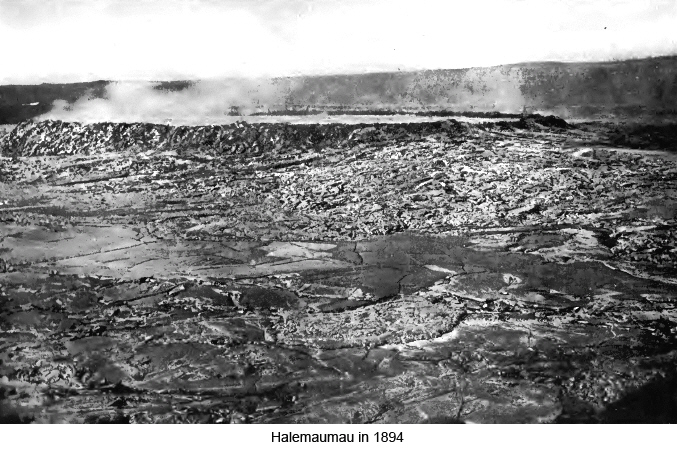
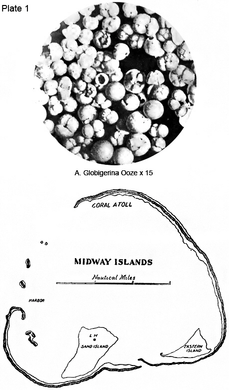
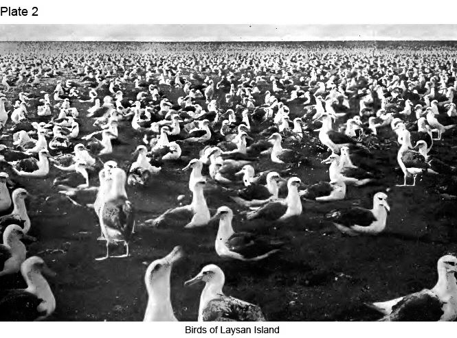
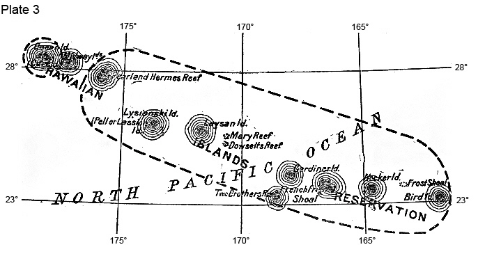
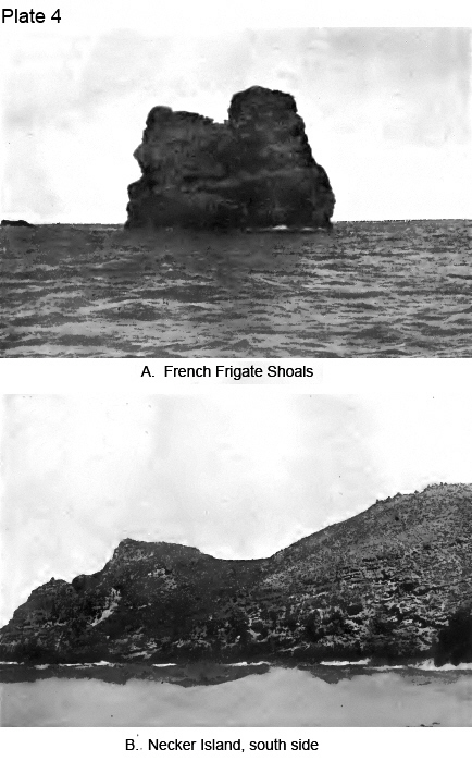
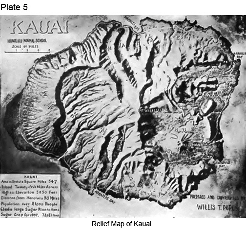
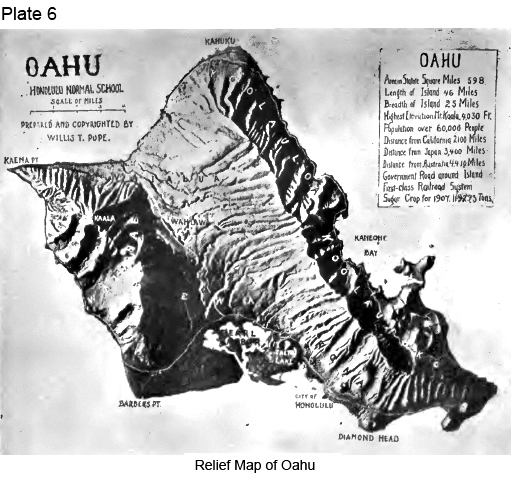
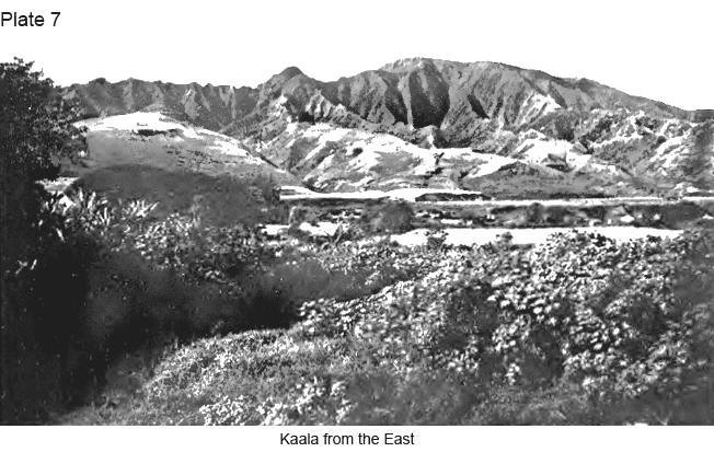
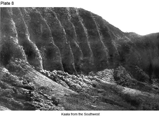
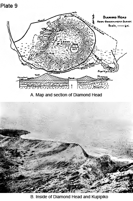
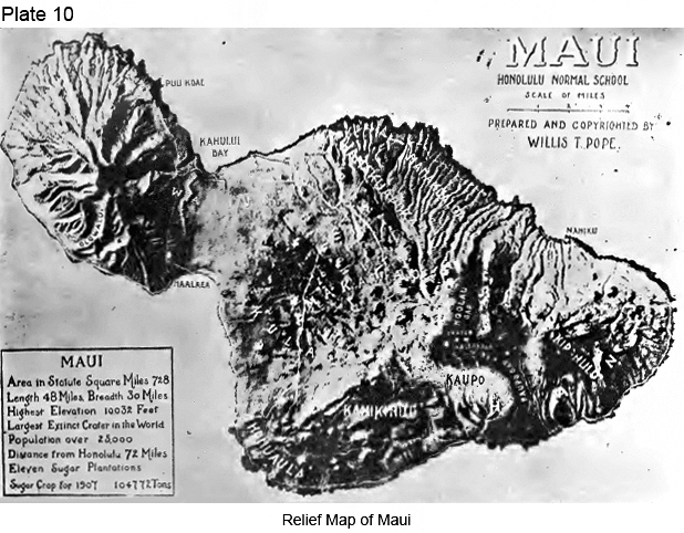
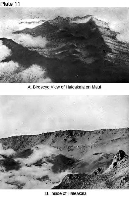
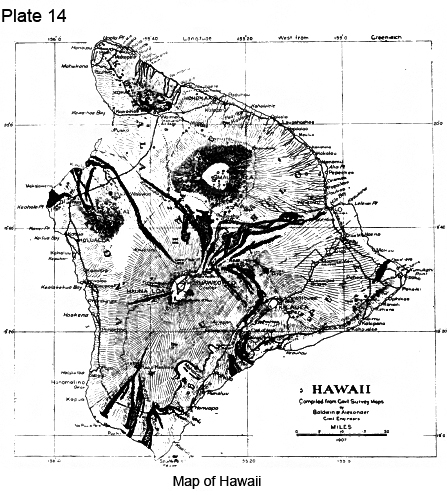
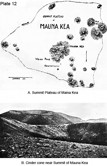
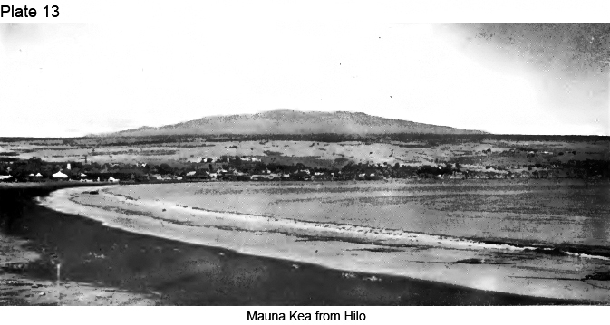
|
|
|
|
|
|
||
| History | Atlas | Culture | Language | Links |