Hawai`i and Its Volcanoes
|
Hawaii and Its Volcanoes by Charles H. Hitchcock, LL.D. of Dartmouth College EARTH SCIENCES LIBRARY, COPYRIGHT, 1909 BY THE HAWAIIAN GAZETTE Co., LTD PART 4: The Hawaiian Type of Volcanic Action
The Hawaiian Type of Volcanic Action The Ordinary Work of the Volcanoes The Ascensive Action in the Lava Column Eruptions from Kilauea Previous to 1820 Eruptions from Kilauea After 1820 Sympathy between Mauna Loa and Kilauea Lunar and Hawaiian Physical Features Compared B. The Place of Origin of the Moon D. Analyses of Hawaiian Igneous Rocks
The Hawaiian Type of Volcanic Action
If one should attempt to classify volcanoes he must take into account their history, geographical position, petrographical character of the lavas emitted and other products, the variable fusibility of the flows, their styles of eruption, shapes of the mountain built up, descriptions of the several sorts of craters, and other matters. It will not be convenient for us to consider any general classification, but we will simply state what features of form, history and style of eruption are characteristic of the Hawaiian volcanoes, with occasional allusions to what may be seen else where, by way of contrast. The details presented in Parts II and III will furnish illustrations of the several phases of action.
At the outset it will be proper to state that upon the Island of Hawaii there are five great volcanoes; the Kohala region and Mauna Kea, both now extinct; Hualalai, Mauna Loa and Kilauea. Our studies have been confined chiefly to the last two, because their activities appeal to us. The investigations into the histories of the others would suggest what might be termed post mortem examinations. Each of these volcanoes may be said to have its own sphere of activity. Some authors regard Kilauea as an appendage of Mauna Loa. It seems best to us to regard them as thoroughly distinct above the sea level, though we expect to show that they may be one deep down. Mauna Loa extends to the bases of Hualalai and Mauna Kea upon the northeast and northwest. Upon the south it probably includes the south point of the island as far east as Punaluu; thence the southern edge may be traced nearly along the road through Pahala and the Halfway House to the lowest depression between Uwekahuna and the slope of the greater mountain. From thence we conceive it to continue along the same general direction to the bottom of the slope near the saw mill erected to cut the koa lumber, two miles northeast from the Volcano House. The impression prevails that there is a considerable elevation to the north of the sulphur banks which has been called Mount Kilauea. To my eye there is a plateau scarcely exceeding the height of the carriage road from the Volcano House towards Glenwood for two or three miles, consisting of the flat basalts of Kilauea, covered by the dark ashes thrown out by explosive eruptions. There seems to have been a flow of lava from some two or three miles east of Kilauea east and northeast, marked by the absence of trees, and therefore corresponding to the line of the trail from Olaa to the volcano in use before the construction of the carriage road. This may be followed to Pahoa, sixteen miles from Hilo. Whatever lies north of this flow seems to belong to Mauna Loa, and everything to the south to be embraced within the sphere of influence of Kilauea. The projection of land at Leleiwi, southeast of Hilo, nearly ten miles wide, would seem to belong to some ancient flow from Mauna Loa. The Kilauea area would commence at a point at Punaluu, expand to thirteen miles width between the koa mill and Keauhou, and to retain about this same width to Cape Kumukahi.
There is a bend of the line of activity from Keanakakoi southeast on the road to Puna, and thence northeasterly near the line of the flow of 1840: and it is possible that the area designated above as belonging to Kilauea may lose a portion of itself when the country has been better explored. That there is a line of heat as far as to the Eel's Eye and beyond is very evident. To the south from near Kalapana to the end of the flow of 1823, two or three miles mauka from the coast is a pali more than twenty miles long and often several hundred feet high, on the makai side of which the land has been depressed by faulting. There is a constant tendency to submergence along this coast, as shown at Kalapana in r868, and it is claimed that there was a slight depression near Pohoiki manifested at the earthquake of September, 1908.
A further indication of the distinctions between the Mauna Loa and Kilauea spheres of activity is suggested by the differences in the temperatures of the spring waters between Punaluu and Puna as stated by Mr. Guppy. The warmer waters suggest the influence of Kilauea, while the colder temperatures are in the area of Mauna Loa. Back to Contents
The Ordinary Work of the Volcanoes
For most of the time the activity of the volcanoes is rather commonplace. There is a daily routine of work much like respiration and assimilation in the human body, partly illustrative of a kind of life and partly a preparation f or eruptions. The most prominent feature is the presence of lakes of liquid lava, which emit heat and vapors and throw up jets. The surfaces are crusted over and the congealed layer breaks up into irregular blocks which sink and disappear. Fumes of sulphur and aqueous vapors arise from the caldrons, causing visitors to avoid their leeward sides. What may be termed smoke mixed with the vapors will develop clouds overhead or rise in columns spreading out like the branches of trees or an opened umbrella. Many instances have been cited of the presence of these clouds over Mokuaweoweo, some of them being charged with fine cindery particles and others not to be distinguished from cumulus clouds formed by the precipitation of vapors in a colder region. The tree is evidently an attenuated variety of the copious discharges in times of great activity.
The ebullition is constant. Certain portions in their efforts to rise as bubbles do projectile work, accompanied by noises. The jets spout upwards as much as thirty feet and the action is rhythmical. Some speak of these jets as dancing joyously with many variations of height and position. The spiracles are where the melted matter solidifies drop by drop as it is thrown up. The jets are more numerous along the borders because the heat escapes more quickly in the center and thus is cooler.
The Pele's hair, where the flying drops are pulled out into long threads is another instance of projectile action. The knotted parts may enclose crystals.
There seems to be a constant supply of the igneous material, so that the lakes overflow. At first the cooling of the overflow builds up a dome or column. Then the streams flow like rivers all over the floor, perhaps cascading, till the pit is filled up, and then meandering into all the low spaces. Since 1823 the cone of Halemaumau has been built up as much as six hundred feet. The vapors are mostly steam, sulphurous acid, a little carbonic acid, hydrogen and atmospheric air.
The source of the water has been referred to rain, the ocean and the original magma of the interior. The rainfall in the eastern part of Hawaii is excessive, reaching to two hundred inches a year at Hilo, and it is rarely the case that visitors fail to receive a good drenching. Because the volcanoes are insular the ocean is not far away; and it is believed commonly that the seawater gains access to the interior fires for the eruptions, if not for the constant requisite supply. In Vesuvius the entrance of seawater with its dissolved sodium chloride may explain the presence of so much sal-ammoniac and copper chloride among its minerals. Traces of them have been reported for Kilauea, but I have never been able to find any material token of their presence. Hydrochloric acid is so pungent that it could not fail to be detected, if present. Possibly the bright red saffron and orange spots among the lavas may have been produced by the conversion of iron chlorid into ferric oxide; but if there is iron chlorid in the lava brought from the ocean, why should not the other chlorids be present?
Vesiculation is justly appealed to as evidence of the presence of water or steam. Professor Dana has fully discussed the matter. He describes five styles of it.
Very little water is required for most of this vesiculation; no more than that of molecular diffusion. When a specimen containing forty per cent of vesicles has its specific gravity determined and compared with that of the same material solid, it is found to be as 1.88 to 2.98. The required water is hence .0003 per cent of the bulk or .0001 of the weight of the mass. The amount of moisture required to produce the vesiculation of the thread lace scoria was determined to be 3.125 per cent of the bulk or 1.1 per cent by weight.
Some have conceived that the downward ingress of water would be checked violently by the intense heat at great depths. The best authors do not accept that view; partly because when the temperature of the critical point of water (773° F.) is reached, dissociation takes place, and there may be an attraction rather than a repulsion. The absorption of the water will increase the bulk of the lava, so that there will be a greater pressure in the lower part of the conduit, perhaps enough to force the material to the surface: and thus vesiculation may be an important element in producing projectile results.
It has been noticed repeatedly that the liquid lava enlarges its area by dissolving its retaining walls. Floating islands and debris cones have also disappeared; and it is a question whether the greater part of the calderas have not been enlarged in this way. Heated silicates possess greater powers of dissolving refractory substances, especially when under pressure; but this opens too large a subject to be discussed here. Back to Contents
The Ascensive Action in the Lava Column
Perhaps the first suggestion of the uplifting action came from Prof. C. S. Lyman in 1846, following observations two years earlier by Mr. Coan. In 1844 Mr. Coan found that the lower pit formed in 1840 had been filled up, ostensibly by overflows of lava. Two years later (June, 1846) this pit was nearly obliterated, and there were wide canals of liquid lava intervening between the black ledge and 1he area of the lower pit. By July, 1846, the pit was filled up and Mr. Lyman concluded that the interior had been elevated, in some parts above the black ledge, which had remained stationary. When the pit was depressed many blocks of lava had fallen into it, making a talus on the floor after elevation. These fragments formed a ridge inside of the canal (shown in Plate 30) higher than the black ledge from which the blocks had fallen. This phenomenon he attributed to the "combined effect of repeated overflowing together with the upheaving agency of subterranean forces." Mr. Coan subsequently noted further movements in the same direction.
In 1848 Mr. Coan describes the formation of a crust over the lake of Halemaumau, which was soon raised into a dome two or three hundred feet high from which one could look out upon the surrounding country beyond the outer wall. This dome was said to have been "formed by the compound action of upheaving forces from beneath, and of eruptions from the openings forming successive layers upon its external surface:" This dome collapsed in 1855.
Meanwhile the interior area continued to rise, and streams of lava to flow over the black ledge adjacent to the walls, while the original talus of 1846 is discernible upon the map of Mr. Brigham made in 1866. It was very nearly a plain in 1868 when two-thirds of the floor fell down as much as six hundred feet, leaving a lower pit comparable with that figured by Drayton in 1840, and a black ledge encircling the outer walls a hundred feet higher. Thus the removal of the subterranean support of the mass that had been slowly rising for thirty-eight years caused the disappearance of the columnar block.
The subsequent filling of the lower pit till the breakdown of 1886 was mostly effected by flows from Halemaumau, but the "crag walls" and circular debris about the principal lake up to two hundred feet altitude are to be ascribed to the ascensive column.
Three months after this collapse, the cone within Halemaumau began to rise. Several figures illustrate these changes. The level upon March 6 was three hundred and eighty feet below the datum point at the Volcano House, the highest point attained by the black ledge thus far in the history of Kilauea. (For convenience the figures showing the variations in the altitude of the ascensive column are calculated as below this datum, with the minus sign.) March 7 the lowest point of the depression was nine hundred feet. See the sections 1 and 2 in Plate 38. The beginning of the rise was more rapid than it was later, viz., one foot per day. In October, I886, the depression had been filled up, in some measure by lava flowing, but more particularly, by elevation of the debris to be on a level with the rim of Halemaumau, three hundred and thirty-five feet. Professor Dana saw the cone in August, 1887, and declared it to be rising slowly. In July, I888, by Mr. Dodge's measurements, Plates 38, 39A, the highest point was one hundred and sixty-two feet. There are no measurements to indicate how much the cone rose later, for nearly a year. In May, I889, the floor and the cone fell eighty feet. But it commenced to rise again till the highest point was attained of about eighty five feet, just before the collapse of March 1, 1891. The horizontal outline of this column, or of Halemaumau, is shown in Plate 43 in its relation to the earlier outline of I886. The falling of the floor to nearly five hundred and fifty feet indicates how much the ascensive column was depressed.
After this depression the refilling of the pit was occasioned chiefly by the accumulation of lava; but on March 2I, I894, there was a sudden elevation of the north wall to the extent of eighty feet, which must be referred to another ascensive movement, though it does not seem to have been very important, as it had mostly disappeared before the collapse of July 8 to 11 following.
The presence of fault planes parallel to the outer wall of the caldera or to Halemaumau as seen on the map of I865, or to the outline of Kilauea iki, would suggest some relation to ascensive columns. Hence a careful study will tend to increase the number of these columns in all the calderas. They illustrate also the sympathy discernible between the volcanoes.
A column of basaltic material rising between circular walls reminds one of the obelisk or spine forced upwards in the late eruptions from Mont Pelée in Martinique and at Bogosloff in Alaska. These were not permanent because of exposure to denudation; but if they had been protected like the ascensive columns in Kilauea, they might have endured much longer. It is conceivable that the spine may sometimes be elevated from one side as a horizontal block, so as to be like the elongated rectangular mountains now projecting above the floor of Mohokea. They may bear kinship also to laccoliths.
The force that elevates these columns must be the pressure of the deep seated mobile lava seeking an outlet, and of course intimately related to the general theory of volcanic action. Some have spoken of this action in Kilauea as if the column were floating on the surface of the subjacent lava. When more lava is supplied the column rises; and after the removal of the liquid the debris will sink back, following it downwards as far as possible. Back to Contents
The ordinary work of the volcanoes is accumulative. The molten lava has been gathering at the apex of the ascensive column in such amount that there is not strength enough in the containing walls to keep it in place, and it flows away down the mountain side, or else disappears in an unseen abyss. As soon as relief is granted by a discharge the volcano is quiet, and the ordinary work is resumed until there is material enough for another eruption. There may be said to be four kinds of eruption: first, those escaping from orifices high up the mountain; second, those emitted from fissures quite low down, accompanied by severe earthquakes; third, those that disappear into the earth, breakdowns or downplunges; fourth, those that are submarine. In Hawaii flows from the surface, or edge, of the calderas, have never been seen in historic times.
Viewed from a different standpoint the eruptions may be quiet or explosive-the first being where the lava flows like water with out much commotion: the second where the discharges come out from orifices like cannon from ordnance, scattering projectile fragments. Our eruptions are so commonly of the first class that they have been regarded as representative of the Hawaiian type. But the recorded history has demonstrated, as stated by
J. W. Judd, that the "two conditions are presented by the same volcano at different periods, and pass into one another by the most insensible gradations." As has been often intimated, a noise or earthquake shock has usually preceded the eruptions when the observer has been located near the place of outbreak. A person in Hilo could not know by observation whether there was any disturbance attending the sudden illumination of the sky in Mokuaweoweo forty miles away. Because he hears and feels nothing he assumes that the action is absolutely quiet, but those who happen to be stationed near the outbreak commonly speak of light or heavy earthquakes. So it has seemed to me probable that earthquakes accompany every outbreak of the first class. The presence of fragmental materials and heated vapors in the discharges from Kilauea in 1400 and 1790 indicate eruptions as violent as anything recorded from Vesuvius.
Mauna Loa has been the grand theater for lava flows. The first symptom of an eruption there is the sudden illumination of the sky caused by the reflection of the molten lava. Mokuaweoweo has been empty and quiet, till all at once the end of the ascensive column brings in a flood of lava. If the sky is cloudy the light cannot be seen. Within a very few days there is an outburst from some point below on the side of the mountain, and the stream begins to flow, starting from an elevation of from 10,000 to 12,000 feet above the sea.
At the point of outbreak what has been called a terminal cone is formed-well seen in Plate 21, known as the Dewey crater, in 1899. These are made of lapilli, and may be seen at the sources of all the historic flows, as well as many more that are pre historic. It would seem that hydrostatic pressure causes the lava to rise from an orifice perhaps hundreds of feet. The jet is highest at first, and disappears when the flow has ceased. The lapilli are simply the cold splashes of the liquid. The various facts relating to the dates, altitudes, duration and other elements of the flows can be seen best from tabular views. Back to Contents
From the tabular view of the eruptions from Mokuaweoweo and Mauna Loa the following facts seem to be established. There are five different features of which three are sometimes combined.
In the midst of accurate, possible and indeterminate figures for heights, I have selected those that seemed the best for the table, and assume that the molten lava rises gradually from the bottom of the pit after a collapse to the time of the next culmination. When there has been an uplift of the cindery blocks by flotation upon the liquid, mention is made of the top of the dome or cone resulting. For the depth of the pit after the first down-plunge, there is the original estimate of Mr. Ellis of eight hundred feet below the black ledge added to the trigonometrical measurement by Lieut. Malden the following year of nine hundred feet for the height of Uwekahuna above the black ledge. In 1834 Dr. D. Douglas figures the depth of the lowest pit at 1,077 feet. Assuming the correctness of the annual average rise of the pit from 1832 to 1840 of seventy-one and one-half feet, one hundred and fortythree feet must be added to I,077 = I,220 for the depth in 1832. His figure for the height of the western wall of seven hundred and fifteen feet above the black ledge would make the depth of the pit three hundred and sixty-two feet, to which must be added forty-three feet more to the molten lava.
For 1840 the figures are those of Captain Wilkes. After this date came the ascensive column of debris floated upon liquid lava three hundred feet high in 1848. As lavas were projected fifty to sixty feet higher in 1849 it is assumed that three hundred and fifty feet will represent the level attained by the liquid. For the depth of the pit there are no data; and it is assumed that its level may have been the same as in 1840. For the 1855 eruption we have only the estimates of Dr. Coan of six hundred feet for the dome above the bottom of the floor of 1840. Mr. Weld was satisfied that the depth of the pit was considerably less than 1,500 feet. If this be placed at 1,200 feet it will conform to the levels both earlier and later.
For 1868 the lower pit is estimated from various reports to have been six hundred feet deep. The black ledge is assumed to have been fifty feet higher than in 1840, or six hundred feet below Uwekahuna, making this pit 1,200. In 1880 the pit had become filled up and the middle portion was higher than its edges; the whole floor might be styled the black ledge.
Beginning with 1886 the figures for altitudes in this table are supposed to be correct though not entirely satisfactory.
The growth of the black ledge has been continuous. It has been measured at two points; at the base of the western wall, Uwekahuna, and where the trail from the Volcano House strikes it. The following table will show the probable figures:
The estimates for the altitude of the cone of Halemaumau have varied greatly, as may be seen by referring to the statements detailed previously. The one given in 1886 by the Government Survey appears to be the most accurate, making a cone sloping one hundred and sixty-three feet to the northeast wall, one hundred and twenty-five feet to the north, one hundred and five to the western side below Uwekahuna, eighty feet to the southwest. Miss Bird had recognized in 1874 the fact that Halemaumau was a hill top. In 1874 a barometric measurement gave it a height of one hundred and sixty-two feet. C. J. Lyons made its altitude one hundred and seventy-five feet in 1878. Prof. Brigham estimated it as three hundred and fifty feet in 1868.
In 1900 M. M. O'Shaughnessy measured it two hundred and seventy feet. In 1905 W. H. Pickering gave it as two hundred and thirty feet. Our latest estimate is about twenty feet less.
The features of the eruptions from Kilauea may be classified like those from Mokuaweoweo.
In addition to these Kilauea may add another conclusion, that in 1420 and 1790 there were explosive eruptions.
In many of the eruptions from our volcanoes the lava sinks into the earth and is lost sight of. There must be cavities in the interior capable of holding whatever fluid has been accumulated in the ascensive column. Some of them may be compared with the tunnels beneath the surface flows, or to their mouths, as discerned at the sea level. The deeper down the cavern the smaller will be its dimensions. Even the porosity of the basalts will disappear at great depths. Back to Contents
Mention has been made of the presence of small fountains in the lakes of Kilauea as being ordinary phenomena. During the eruptions from the greater caldera several lofty fountains of lava have been observed: and the evidence for their reality cannot be gainsaid. The annexed table shows the years when these fountains were seen, the heights of their place of outbreak above the sea (A) and the reported altitudes of the fiery jets (B):
The data for 1865 are from Mr. Green, who speaks of the fountain as important, nor does he state more definitely the conditions in 1875. The figure of 12,800 is intended to mean that the fountains issued from the floor of the caldera.
If the liquid arises like water because of hydrostatic pressure, the locations lowest down should show the highest jets, which does not seem to have been the fact. But the higher flows have proceeded from smaller apertures; the lower ones from rents or fractures which allowed the lava to discharge more rapidly and easily. This principle could not apply to the jets rising from the summit. Whatever force raised the lava to the floor of the caldera must have caused the fountains to play there, and also the protrusion of the liquid from crevices still higher, as has been reported several times.
In 188o Mr. Goodale reported that the lavas were thrown sixty to eighty feet above the brink of the crater when they were looking at the fountains upon the floor. What may have been protruded at this same time has been described by Rev. Janus M. Alexander in 1885.
Concerning the exudation of lava from seams at the summit W. L. Green writes: "Molten lava has often been seen to rise from cracks at the very summit of Mauna Loa, when the bottom of the crater of Mokuaweoweo remained undisturbed. This, however, only agrees with the phenomena which have been observed about Kilauea, and in addition to the explanation suggested in that case may merely mean that a free communication has been opened in those spots, whilst it has remained closed, or more restricted, at lower levels."
Add for Kilauea-iki in 1832 and 1868, and Keanakakoi for 1877, similar eruptions from the walls higher than the usual discharges. Back to Contents
Sympathy between Mauna Loa and Kilauea
Much has been written upon the question as to how our two great volcanoes stand related to each other. Attempts have been made to show a species of parallelism in the volcanoes of the archipelago – the latest are by Professor Dana representing that Kaala, West Molokai, Lanai, Kahoolawe, Hualalai and Mauna Loa lie along one line, while the greater series is from Kauai through Koolau, East Molokai, Maui, Kohala and Mauna Kea to Kilauea. Mr. Green proposes the tetrahedral scheme, according to which all the volcanoes are near the intersections of two out of three sets of fissures disposed at angles of sixty degrees to each other. Both schemes agree in granting separate existence to Mauna Loa and Kilauea; the latter is not an appendage to the former.
The similarity of the rocks indicates consanguinity. Both carry basalts with or without olivine, the same specific gravity and various minute details of composition.
Both are calderas and discharge their lava in similar ways.
But the main question is still, why should there exist only twenty miles apart two columns of liquid lava approximately 10,000 and 3,500 feet in altitude above the sea? If both come from the same reservoir why should not the discharge be from the end of the lower arm of the syphon, especially when the upper arm is filled? Or why should there not be a sympathetic action between the eruptions? Observers have often said that one volcano was asleep while the other was in action.
Mr. Green endeavors to show by experiments that liquids of different densities will not necessarily stand at the same level when connected in separate upright glass tubes joined to a horizontal pipe containing a basal fluid. His assumption is that there is a variation in the densities of the Hawaiian lavas sufficient to sustain columns of varying lengths, particularly when they have different diameters; the smaller tubes suffer a greater proportionate loss of heat. The temperature is maintained by convection currents. But he insists that a rise in the Mokuaweoweo column would not necessarily cause the Kilauea lavas to ascend; so that the sympathy supposed to exist would not be displayed. The best starting point in this discussion is a comparison of the correspondencies and differences between the eruptions of these neighboring volcanoes, citing only those that are well known.
Averaging the figures so that when the eruptions occur exactly synchronously or during the same calendar years they will be on the same horizontal line, and having the eruptions that do not agree placed between the others, the conclusions suggested are almost startling.
First – the years of agreement are 1832, 1849, 1855, 1868, 1877, 1887, 1907. Three of those upon Mauna Loa, 1868, 1887, 1907, broke out only low down and were preceded by severe earthquakes. The most natural suggestion is that the simultaneous discharges were occasioned by the great depths of the lava: the mountain having refused to yield to pressure higher up. Because the pressure was intense the earthquakes were violent and fissures were produced, and the discharges though voluminous were effected very briefly. The 1855 eruption from Mauna Loa was one of the largest ever known. Those of 1832 may have been synchronous and not six months apart, as has been stated previously.
The light on Mokuaweoweo in May, 1849, was not observed till after the fire was conspicuous at Kilauea, and Mr. Coan was not able to say that they were coincident, though the statement implies it. There have been, therefore, seven eruptions that were synchronous upon the two mountains. Second, upon the supposition that both columns had the same basal support, the discharge in the times between the joint eruptions was confined to one of the two volcanoes, the pressure not being sufficient to render both active. And there has usually been an alter nation from one to the other. The greater column has sustained nine of the intermediate discharges, in 1843, 1851-2, 1859, 1865-6, 1872-7, 1880-1, 1896, 1899 and 1903; Kilauea has been active seven times, in 1866, 1879, 1886, 1891, 1894, 1902 and 1908. There may have been fire in Mokuaweoweo in 1823 and 1840 unrecorded, because of the absence of observers or because of concealment by clouds. Just why one or the other of these columns should have been affected to the exclusion of the other is not apparent.
Second – Mr. Green finds sympathy in the action between the two volcanoes not merely when the eruptions are synchronous but when increased activity has been observed in the supposed quiescent column either shortly before or after the main outburst. Lava does not exhibit as clearly as water the tendency to preserve a level, because it is viscid even at high temperatures. In all cases of the Mauna Loa eruptions at high altitudes the lavas in Kilauea have also been high, though not to the point of discharge.
In February, 1852, the lavas ran in a large stream on the northeast side of Mokuaweoweo. A month later Kilauea exhibited increased action. October 30, 1865, a brilliant light was displayed in Mokuaweoweo and continued for four months. No streams were known to have flowed from it, and no visitors climbed to the summit. Just after the disappearance of the light, new lakes of fire and cones appeared from Halemaumau to the northwest, north and northeast, as well as towards Keanakakoi. The surface was flooded for a distance of two miles and a breadth sometimes of half a mile, preventing access by the usual route to the great lake for months. Now the chronicler says no sympathy was exhibited by Kilauea with the summit fire; but Mr. Green calls attention to the fact that the moment action ceased at Mokuaweoweo it began in Kilauea. "The lava columns in the two mountains have been rising steadily together. The cessation of apparent action in the summit crater of Mauna Loa may merely mean that the immense mass of lava discharged over the bottom of the crater of Mokuaweoweo had finally cooled and sealed up the opening. But the gradual rise of the lava in Kilauea keeps on," and culminates a year and a half later in the double eruption of 1868.
The igneous manifestations on Mauna Loa from 1872-7 culminated in an earthquake and submarine eruption the last of February. The activity was soon transferred to Kilauea, as manifested at Keanakakoi in August, and almost continuously about Halemaumau till the collapse of April, 1879; after which it was quiet for a couple of months.
Both the volcanoes were active in May, 188o, in South Mokuaweoweo and Halemaumau. The lava had been steadily rising in both columns and continued ready for a discharge till November, when relief was afforded by the flow from Puka Uahi, lasting for nine months and reaching to the margin of the village of Hilo.
The next action was at Kilauea in 1886, there being lakes of lava varying slightly in detail but gradually increasing from 1880 till the minor collapse in March, 1886. Mokuaweoweo seemed almost extinct till the time of the double eruption in January, 1887. The scene of activity was again exhibited in Kilauea alone, culminating in 1891 and 1894. After that came the two displays of 1896 and 1899 upon Mauna Loa and the contemporaneous inactivity of Kilauea. The latter awoke again briefly in 1902 and Mauna Loa in 1903, but there was not much stirring in either pit till the last recorded double eruption in 1907.
Third – The intervals between the periods of joint action are somewhat suggestive of an approximate twenty year cycle, the figures being in order from 1832, 17, 6, 13, 19, 20. Possibly the 1855 episode was a supplement, as the intervals of 6 and 13 add up to 19.
Fourth – The old notion that volcanoes are safety valves is not so far astray after all. It is pressure from below that gives rise to eruptions. If relief is not afforded by discharges at high levels, the tension brings on earthquakes low down, and after great chasms have been opened the lava flows out and then quietude is restored.
It is conceivable that the retaining walls might be strong enough to withstand the pressure down to or below the sea level. If so the probability would favor the coming of a violent explosion like those from Vesuvius or Tarawera; unless the discharges in the ocean as in 1844, 1877, 1884, etc., afforded the proper relief. Back to Contents
Pahoehoe and AA
The terms pahoehoe and aa, expressive of the two principal classes of lava are of Hawaiian origin, whence it is evident that the natives early appreciated their peculiarities. They have now taken a fixed place in volcanic terminology in spite of the protest of Professor T. G. Bonney, and have been recognized as existent in other countries and older formations.
Pahoehoe is the most common of the two. The name signifies having the aspect of satin, a shining smooth surface. It is quite hummocky because the liquid stiffens very quickly after exposure. Water is smooth in rivers, but when the temperature falls below the freezing point the surface will bulge much like the lava. Plate 51 represents pahoehoe from the flow of '80-1 near Hilo. On the right the bulging is more domelike: and it represents a stream later than that on the left. The superposition of the later flow is apparent in the photograph. Standing by this variety of lava as it forms, one sees that it is a stream of liquid material, and if a stick be thrust into it red lava will flow out. On the left side the domes show the wrinkling called ropy structure, convex downstream, because the current has a greater velocity in that direction. The crust is flexible and is modulated by the motion of the liquid beneath. Other figures from Kilauea show the same structure. The surface may be more glassy than the substratum because the more siliceous part is lighter than the rest. Beneath the billowy surface may be vacant spaces, left by lava which has run out, leaving tunnels, which often are lined by stalactites. The rate of the flow is variable, depending on the degree of fluidity and the slope. Most observers overrate the velocity. It took nine months for the flow of '80-1 to reach Hilo, a distance of thirty miles.
The study of the aa has not yet revealed to us its proper nature and origin. All travelers avoid crossing it if possible unless the highway surveyor has pulverized its roughness, when it makes an admirable road. Those who climb Mauna Loa travel miles to avoid crossing it.
Two examples are very prominent; the first between Kilauea and the Halfway House, Plate 26.
It starts from near Puu Ulaula, descends the south slope and when near Kilauea turns to the southwest. For many years this curved ridge figured as the "flow of 1823," but this label has proved to be erroneous. The roughness of it where traversed by the road for six miles beggars any possible description. The fragments are larger than usual, from three to five feet in length. The other illustration is the long embankment below Aina Hou near Humuulu sheep station, situated as if it were a spur from the flow of 1843, with scarcely any descent. It was an older flow, creeping along like a caterpillar, and effectually imprisons the cattle in the mauka grassy area. Plate 50 shows aa from the flow of 1887.
When minutely examined the aa ridge is seen to be composed of bristling ragged rocks, incoherent, with an occasional smoother piece like a bomb. The fragments in the original streams are not cemented together any more than cobble stones in a gravel bank. The blocks may be a few cubic inches to a thousand feet in size, dumped to a height of twenty to forty feet; they are brittle, not scoriaceous, slightly vesiculate, easily broken down. Professor Dana says, "The reader's conception of it will be feeble at the best if he has not already had a view of chaos." When in motion D. H. Hitchcock thus describes it: "The whole broad front of the then sluggish stream was a mass of solidified lava twelve to thirty feet in height, moving slowly along by breaking and bearing on ward the crushed covering; along the whole line of its advance it was one crash of rolling, sliding, tumbling, red hot rock, no liquid rock being in sight; there were no explosions, but a tremendous roaring, like ten thousand blast furnaces all at work at once. The rough blocks lie piled together in the wildest con fusion, many as large as ordinary houses-and the movement is slow."
Others refer to a red heat among the blocks, while the fused rock rarely exudes, but insist upon a heavier molten fluid beneath supporting the bristling fragments, and a rolling action in the front part. I have sometimes compared the onward motion to the flow of burning anthracite coal, when unintentionally by the opening of the grate beneath a quantity of it escapes.
When the stream has been covered for ages the bristling character of the fragments is modified; the surfaces are somewhat smoothed: and in the illustrations to be cited from the older rocks the structure becomes concentric, and the mass resembles an agglomerate. Judge Hitchcock says further of the aa: "This is always the first lava running from all outbursts on Mauna Loa and Kilauea. Pahoehoe does not run from under aa, but commences near the fountain head as pahoehoe. The liquid lava under aa is aa, not pahoehoe, as seen in 1880-1 by Professor Alexander and myself. A stream of liquid aa flowed from under aa rock and cooled into aa."
At first it was supposed that the aa was a clinker field; the breaking up of a partially cooled pahoehoe stream, like river ice in a spring freshet. Later it was thus expressed by Captain Dutton, "When these lavas are discharged they come up out of the ground in enormous volumes, are intensely heated, and are very liquid. As they become cooler they become viscous. The cooling takes place upon the surface of the mass while the interior still remains hot and preserves a viscous liquidity. The fields of aa are formed by the flowing of large masses of lava while in a condition approaching that of solidification. The same stream may exhibit pahoehoe or aa according to the circumstances attending the flow, and the final form which the stream takes is quite independent of the chemical constitution of the lava."
Professor Brigham says: "The aa seems to occur when the lava meets with an impediment, which gives way just as the lava is granulated, rolling the spongy mass over, and building up huge piles from which the liquid drains away."
W. L. Green remarks that the aa looks like a great scoriaceous railway embankment "down the center of which the lava continues to flow in a molten state, forming ultimately a solid arched crust which falls in from contraction, though the tube may be miles in length. The convexity is the same in all streams, and there is no necessity for invoking the presence of water."
Other observers insist that the first lava issuing from the Hawaiian volcanoes is always aa.
E. P. Baker writes: "I have stood by a wholly molten stream of lava which miles below was cooling into aa."
Dr. S. E. Bishop follows D. H. Hitchcock's general statements, and claims that the vesicles of pahoehoe are spherical ; but as the fragments roll along half cooled, the vesicles are pulled out of shape and ragged misshapen forms are developed.
Professor Dana concludes:
To make this suggestion worthy of consideration, it would be necessary first to show from the actual distribution of the aa that moisture was more abundant beneath it than under the pahoehoe.
Water appears in streams and pools, or to a limited extent as rainfall; but does not seem to show any partiality for the one class of the lavas rather than the other. There was an interesting illustration of the behavior of a lava stream in Catania, Sicily, in 1843. A stream of lava had invaded the cultivated land. Suddenly its extremity was seen to swell up like an enormous blister and then to burst, discharging a quantity of steam with a volley of fragments, solid and liquid. Sixty-nine persons were injured. The catastrophe appeared to have been caused by the lava flowing over a subterranean reservoir of water, thus suddenly generating steam that caused the explosion.
Other ways in which the lava streams have been affected by water have been cited, none of them resembling aa.
The aa is not confined to Hawaii. I have noticed streams of it in California when passing through the Mojave desert. It has been recognized by J. Morgan Clements in the ancient rocks of the Vermilion iron bearing district of Minnesota.48 He found many bunches of igneous rocks having a concentric structure, and refers them to the pseudo-bombs of aa, based upon the descriptions of Professor Dana. Since then I have referred diorite dike in the Silurian rocks of the Ammonoosuc district of New Hampshire to the same category. Another reference may be to Newfoundland; and I recognize the same structure in some of the Triassic traps near Greenfield, Massachusetts. In examining sections of the Hawaiian basalts in many localities one can easily recognize beds of aa among the various components. In these cases the rough surfaces have been smoothed down. Bunches may be recognized by their concentricity, and possibly by an irregular vesiculation. They must not be confounded with the spherical or rounded masses analogous to the columnar structure. Back to Contents
Areas of the Flows
Mr. E. D. Baldwin estimates that the flow of 1907 covered 9,000 acres of rough land, and sent forth a volume of over 200,000,000 cubic yards of basaltic material. Some of the earlier flows are compared with this. The flow of 1855 covered over 15,000 acres of land and discharged 600,000,000 cubic yards of rock. The flow of 1880-1 covered 20,000 acres of land and discharged over 540,000,000 cubic yards of rock. The flow of 1859 was comparable with that of 1855. These estimates do not allow for the material that passes off into subterranean cavities and are suggestive rather than accurate.
By inspection of the map of Hawaii, one can see delineated the areas occupied by the historic flows from both the volcanoes. Above 9,000 feet the surface is a complete network of lava streams finely exposed because of the absence of vegetation. It would be an interminable task to unravel these twists. To some extent their relative edges could be deciphered by noting the degrees of freshness exhibited. The whole dome of Mauna Loa, down to the base of the cone, nearly 30,000 feet, is but a congeries of lava flows. When one considers how little the bulk of the mountain is made up of the few flows delineated on the map, and how small a portion of the whole mass this can be, he is overwhelmed by the certainty that there were millions of streams, and that many millions of years must be assumed in order to say how old the mountain is. It must have commenced to build up long before the Tertiary period. Back to Contents
Volcanoes may be classified by the petrographical character of the lavas which they emit: for the fluidity of the material, the temperature of fusion and the shapes of the cones are determined by the assemblage of the constituent minerals. The materials are spoken of as basic or acidic. The basic lavas are those carrying iron, lime and magnesia in large amount, and small proportions of silica or the lime-soda feldspars, the augitic and allied ferromagnesian silicates, iron-oxide, but no free quartz. The rocks thus made up are termed basalts, dense and fine grained, with or without olivine.
They are the most fusible of the lavas, melting at the temperature of 2250° F. The acid lavas carry much silica, potash feldspars, hornblende, mica and quartz and are termed trachytic and rhyolitic. They fuse with difficulty from 2700° F. to 3100° F. Between these two classes are intermediate forms, composed of lime soda feldspar, augite or hornblende and frequently quartz, and have a medium degree of fusibilty, 2520° F. The form of the cone is dependent upon the degree of fusibility. Those of the basalt order, easily liquefied, build up cones with slopes of less than ten degrees; those of the trachytic order build up cones with slopes from twenty-eight to thirty-five or forty degrees. It is the degree of fluidity or pastiness of the lava that produces the shapes of volcanoes, modified by the presence of tuff or cinders.
With these distinctions in mind it is easy to perceive that most of the Hawaiian volcanoes belong to the first order as they are basaltic and have low angles of slope. Mauna Loa is the finest example, being a magnificent dome, concave above where the basalts have accumulated, but with a concave rim at the base, because of eruptions low down. One may be at a loss within a mile of the summit to know where the pit is. That was my experience in 1883 when my guide lost his way because the marks upon which he had relied for his knowledge of locality were covered with snow. The surface is nearly flat for several square miles in extent, and the pit is not seen till you are close upon it. The form of the dome of Mauna Loa is shown in Plate 15, as seen from a distance of twenty miles. In a circle of five miles around the pit the mean slope is about three degrees. Radial lines to the different points of the compass show slopes from about four to six and two-thirds degrees from the summit to the shore line. The slope of the cone of Halemaumau inside of Kilauea is not much more than a single degree. The outward slopes of Kilauea are about one and a half degrees to the northeast and southwest. The south slope is steeper because of displacement by faulting.
These domes are elongated, being elliptical rather than circular. Mokuaweoweo has the course of N. 35° E. for the northern part and N. 20° E. for the southern part, as shown upon the map. About the same trend prevails from the flows near Kahuku to the summit, and beyond to Mauna Kea. To reach the sources of the flows in the south edge of Hamakua connected by the fault line, the direction is about northeast. This southern divergence is paralleled by the similar bend southeast from Kilauea.
Variations in the character of the lava are conceivable, as of rhyolite in the place of basalt; in which case the features of the cone might be altered. Or the supply of heat may be diminished, and allow the outburst of cinders and tuffs: or should water enter the conduit from below, explosive eruptions might occur, like those of the other types of action. The tuffs and ashes emitted explosively upon the other islands seem to be connected with the later lateral monticles.
The most important feature of the basalt volcano is the caldera or pit crater, and this is thoroughly characteristic of Hawaii. The eruptions are always within or from rents connected with the central body of lava. This feature dominates throughout the archipelago, and there are nowhere else upon the planet finer examples of this type of action.
Briefly summarized the Hawaiian type of volcanic action is expressed by the caldera, by basalt, the most easily fused of all volcanic rocks, by the development of an ascensive column from whose summit lakes of molten lava accumulate and flow away intermittently, by a sympathetic uprising in adjacent calderas, by the building up of domes rather than cones from material forced up from below by subterranean power, by displaying magnificent fountains of fire, and usually by rather quiet eruptions and few earthquakes. By way of contrast Vesuvius possesses a cone with curved sides; while basaltic it is composed largely of the trachytic element, builds up cinder cones and discharges bombs and stones in an explosive manner. It was the common doctrine at the time of my visit in 1866 that the eruptions followed the filling of the crater with debris, on the principle that the free egress of volcanic matter was impeded, and that the obstacle must be removed. In 1866 no crater existed, it had been filled up; and true to the principle stated, an eruption ensued in the following year. The question whether there may be an ascensive column has not been studied at Vesuvius. Mineral chlorids are plentiful, as suggested by the greater nearness to the sea, four miles, as contrasted with Kilauea nine and Mauna Loa twenty.
There are some minor points of agreement between the types. They both have periods of filling up, discharging and collapsing, or intermittent action. Some of the vents are fissures at the base of the mountain. The streams of lava form tunnels and show the ropy structure. Both present the spectacle of a dark cloud said to resemble a pine tree, which consists of vapors carrying ashes that are spread over the adjacent country.
Vesuvius is a small volcano compared with Kilauea. The cavity left in Halemaumau in 1886, say half a mile across and six hundred feet deep, represents the size of a crater of Vesuvius. At Kilauea this was but a minor discharge. Possibly it may be better to claim that every volcano has its own type of eruption. Thus, Pelée, in Martinique, was characterized by the terrible hot blast of steam and vapors directed down the mountain side, with mud flows and the rising of the obelisk; Krakatoa by a tremendous explosion with wonderful attendant atmospheric phenomena; Tarawera by the discharge of ashes, mud and scoria from a long rent accompanied by geyser-like action; Baldaisan by the ascent of a dense column of steam and dust with many explosions, a landslide, no flow of lava, and geyser-like action, all accomplished in six hours; Stromboli, by a constant ebullition of liquid lava, known to be active for 2,000 years, and so easily affected by the weight of the atmosphere that it serves as a barometer to the passing ships. Back to Contents
Lunar and Hawaiian Physical Features Compared
Geologists have not been slow to recognize volcanoes in the photographs of the lunar surface taken by astronomers. G. Poulett Scrope presents comparative maps of the craters about Naples and upon the moon, and others have discussed the re semblance between them. In 1905 Professor W. H. Pickering of Harvard Observatory visited the Hawaiian Islands to study their volcanic features, and in 1907 he explored the volcanoes of the Azores, with the intent of learning what light their contours throw upon the lunar craters. He had determined that the lunar craters correspond better with the Hawaiian or "engulphment" type than with the Vesuvian, characterized by explosive eruptions, before starting. The explosive volcanoes have the habit of blowing the craters into fragments in time of eruption; whereas the calderas of Hawaii and the Moon discharge their lavas internally without any important fractures of the walls. The lunar volcanoes are from two to twenty times larger than the terrestrial ones, while the force of gravitation in the Moon is only one-sixth as great as it is upon the Earth. This would allow the former body to support craters much larger than the latter.
Of the three classes of terrestrial craters, the tuff and cinder cones, and the lava craters, only the last need to be studied in this connection, although there are with us examples of the others. The third series may be classified as cones, pits, rings and bowls, most of them very diminutive by the side of their lunar relatives. Other formations are the caves, channels, cracks, blow holes or spiracles, pinnacles and ridges.
Mauna Loa is the finest example of a lava cone, and conceiving the ocean removed, as there is no water in the Moon, it is quite worthy of comparison, with its height of 30,000 feet and a base of one hundred miles. Every island in the archipelago is of the same nature, and usually with several cones present. Bullialdus in the Moon with a crater thirty-eight miles in diameter has the same general contour. Other examples are Kahakau in Molokai, Kuohi, the sixth crater near Kilauea, Halemaumau, Kilauea-iki and several upon Hualalai. These have no elevated borders, are simply holes in the ground, and are compared to some of the lunar maria.
The lunar rings are represented by Schickard, Phocylides and the Sinus Iridium, Plate 48AB. The first has a diameter of one hundred and thirty-four miles, with a depth of two miles. The Sinus Iridium is a good illustration of a mare, with a flat top. The rings of Kilauea used by Professor Pickering to illustrate this phase are the encrusted edges of the lakes of 1891 and 1894. Their rarity upon the earth, compared with their abundance in the moon, may be explained because here they are not permanent. Upon the moon with a diameter of from twenty to sixty miles and a depth of two miles, the destruction of the walls by falling down would not be so common.
The lunar craters have three kinds of floors; either with a central peak, several small craters or without conspicuous detail. The Hawaiian craters carrying central peaks are uncommon, unless Kilauea with its central cone of Halemaumau may be considered as one. Professor Pickering uses several illustrations; see Plate 49, as one near Humuula, Hualalai and east of Kilauea. The ridge along the central line of Haleakala, four hundred feet long and one hundred and fifty feet high may be of this character.
The lava bowls are illustrated by Aloi, the third crater east of Kilauea, and upon Hualalai. Their number upon the moon is very great, being ten times more than all the other depressions combined.
Plate 49 is copied from Professor Pickering's book, illustrating the various cones, pits, rings and bowls found in Hawaii which help in the elucidation of the lunar craters. As their relative sizes are unimportant I have not copied the detail of their scales.
a-b, Tuff cones of Punchbowl and Diamond Head; c, cinder cone on Mauna Kea, compare Plate 12B; d, the caldera of Kilauea from north to south; e, lava cone in Haleakala, compare Plate 11B ; f, lava pit, sixth crater near Kilauea; g, lava cone and ring, and h, ring from Hualalai; i, lava ring with central cone near Humuula; j, lava bowl on Hualalai; k, I, m, n, p, lava piles from Hualalai o Alealea or fourth crater near Kilauea.
The spiracles represent rather uncommon phenomena at Kilauea. Steam rises readily in water, less easily in lava because of the greater degree of resistance to the upward movement. The projectile force must depend upon the viscidity of the lava. Be cause of the liquidity of basaltic lavas, the jets in Kilauea rise only a few yards; the drops fall back still in the melted condition and the jets dance in very lively manner. When somewhat stiffened, the lava mud falls around the vent and cones result, having apertures in the top through which the steam rushes noisily. A still later episode is where the explosive force throws the pulverized fragments high into the air as lapilli, ashes or dust. Various observers have watched this rising bubble in Stromboli, with its bursting and cinder projections. Back to Contents
The lunar spiracles are of larger dimensions than those seen in Kilauea or Hualalai, some of the latter being a thousand feet high. The pinnacles are also more conspicuous upon the Moon than upon the Earth. The same is true of caves and tunnels resulting from the hardening of the surface of lava flows, allowing the liquid to run till the supply is exhausted. These caves were found better developed in the Azores than in Hawaii, where lakes of fresh water and solid cones also appear.
Faults or cracks are common in all volcanic regions, especially mentioned in the palis south of Kilauea and in the fractures produced in the eruption of 1868. Upon the Moon these cracks are known as rills, and are very numerous; and may be also related to the canals upon Mars.
Keanakakoi (Plate 45) is also cited as an illustration of Lunar craters with smooth floors. It is not practicable to set forth farther the similarities between the Lunar and Hawaiian volcanic features. They are to be explained primarily as phenomena characteristic of volcanoes in whatever world they occur; and secondarily as belonging to Calderas, of which the most celebrated examples are in Mokuaweoweo and Kilauea.
A. Earthquakes in Hawaii
Hawaii is regarded as a land where earthquakes are frequent and powerful. Since the invention of apparatus fitted to record the presence of these shocks, and the attention paid to their study in Japan, and under the auspices of the British Association For the Advancement of Science, so great has been the advance in our knowledge of these phenomena, that it is just to speak of the "New Seismology": whatever had been written more than twenty years ago is of slight consequence in the comparison. Under the direction of Professor Milne, sixteen seismological stations have been equipped with seismographs at as many important places all over the world, and the reports from them studied and collated at the Isle of Wight in England. One of these instruments has been established at Sisal, near Ewa, on Oahu. Little has been reported from this station to the public, save that it served to allay apprehension at the time of the great earthquake in 1906 in San Francisco.
There is a crying need for the establishment of a Seismological Observatory near Kilauea, similar to the analogous institution upon Vesuvius, where the phenomena connected with the volcano can be observed, as well as those relating to earthquakes generally. The director of the Vesuvian Observatory has been able to send out authoritative warnings of disaster, which have been utilized by the public like the storm predictions from the National Weather Bureau at Washington. The Hawaiian volcanoes are fortunately situated at a considerable distance from settlements, and people congregate to witness eruptions rather than flee from them; but there is no part of the United States where the study of volcanic and seismic phenomena can be better prosecuted.
In the history of our volcanoes attention has been called to the occurrence of earthquakes, just as visitors happened to have noted them. A better record has been kept at Hilo by Mrs. Sarah J. Lyman, extracts from which have been published from time to time. Although ascribed to the Rev. D. B. Lyman, the first one of them is that published by Captain Wilkes in his Narrative, stating what the disturbances were between 1833 and 1841. After that time the same lady continued her record down to the end of 1885, when her life was ended. The family maintained the record several years longer.
Three classes of seismic disturbances have been observed in Hawaii; first, those connected with the volcanoes; second, those that have been propagated by stresses in the earth away from the islands, sometimes called tectonic; third, the sea waves, where the jar has been communicated to the water of the ocean. Those of the second class are of less account locally than the others. It is important that they should be recorded by the seismographs and correlated with the same shocks in other lands. The inhabitants of the Territory need not be apprehensive of any seismic disaster, except those who live near the volcanoes of Mauna Loa and Kilauea, or in the path of the sea waves.
Of the volcanic quakes, that of 1868, centering in Kau, is the most important. It is esteemed as one of the most forcible series; of shocks connected with a volcano ever described. The statements respecting these disturbances given in our account of the eruption of Mauna Loa in 1868 will recall their terrible nature. All edifices, the trees, animals and men were affected; and sea waves were started at the coast. Many lives were lost. No observers in that day attempted to determine the various elements of the quake; but its connection with an eruption from Mauna Loa is now universally conceded. As in the fable, it may be said that the mountain was groaning to be delivered, and the birth was the deluge of lava shot up high into the air and flowing to the sea. By this occurrence it was evident that some of the eruptions from Mauna Loa were not of the quiet sort. Nineteen years later another eruption from nearby was preceded by earthquakes numerous and violent, and still a third in 1907. And attention has been called to many other similar eruptions coming from the bases of both Mauna Loa and Kilauea in prehistoric times, which may have been equally violent.
When the records of the seismograph at Sisal are published, it will be possible to learn how important the tectonic quakes have been in our archipelago. So far as known, none of this class of shocks have been particularly severe. Quite a number of the sea waves have made themselves felt among the islands, and attention will be called to a few of them. Back to Contents
On the 7th of November, 1837, there was an earthquake in Chile, and a sea wave started by it was felt at the Hawaiian Islands; also at Tutuila in the Samoan group. The phenomena observed at Hilo are thus described by Rev. Titus Coan:
At about 7 P.M. the sea at Hilo was observed to retire far below its usual low-water mark. In a few moments afterwards the water returned in a gigantic wave, rushing to the shore with great velocity, and breaking upon the beach with a noise like a peal of thunder. All the low grounds in the neighborhood of the beach were instantly submerged, and a large number of houses were swept away. So sudden and unexpected was the catastrophe, that many of the inhabitants were engulphed in the flood, and compelled to struggle for their lives. The sea remained upon the land about fifteen minutes, when it retired beyond the line of low water, and after a short interval returned again, but with less violence. It afterwards continued to vibrate for a time, gradually decreasing at each oscillation, until it attained its usual level.
The scene of distress which this phenomenon produced was great. Hundreds of natives were at a meeting near the sea shore, when the wave rushed upon them and left them struggling amidst the wreck of their worldly effects. Some of them were carried to sea, while others were dashed upon the shore, surrounded by the fragments of their houses, which had been broken to pieces, together with the timbers, frames, calabashes, etc.
Cries of distress came from all sides, as well from those who were struggling for life, as those who had come down to their relief. Parents were rushing to and fro, looking for their children, husbands for their wives, children for their parents, each inquiring for the other, with wailings and hallooings. The whole, combined with the roar of the sea, rendered the scene one of thrilling interest. Fortunately an English whaler, the Admiral Cockburn, of which James Lawrence was commander, was lying in the bay at the time. He in a most praiseworthy manner lowered his boats, and kept them cruising about the bay, in search of the natives, many of whom were picked up, wearied and exhausted, and by this timely aid their lives were preserved. Not a canoe was left on the shore to assist in this work. Mr. Lawrence affirms that the water ran past his ship at the rate of eight knots an hour, and that the soundings were reduced from five to three and a half fathoms, which left a great part of the bay dry. Back to Contents
Earthquake Wave of 1868
On the 13th of August, 1868, at 5:05 P.M. an earthquake was started off the coast of Arica, Peru, said to have had a duration of ten minutes. At 5:32 P.M. the first of a series of waves from fifty to sixty feet high rushed in upon the land, penetrating a considerable distance. J. E. Hilgard published an account of these waves in the report of the Coast Survey for 1869; and his conclusions were accepted and published by the highest authorities. The wave was reported at Coquimbo eight hundred miles in three hours, Hawaii (Hilo) in fourteen hours and ten minutes, in Japan upon the following day. The same wave had been reported earlier at San Diego, San Francisco, Cal., and Kodiak, Alaska, with the times respectively of ten hours and fifty-five minutes, twelve hours and fifty-six minutes and twenty-two hours, at the average of three hundred and sixty-nine, three hundred and forty-eight and two hundred and eighty-two miles per hour, and distances of 4,030, 4,480 and 6,200 miles. To reach Lyttleton, N. Z., and Sydney, Australia, 6,120 and 7,440 miles, the time required was nineteen hours and one minute and twenty-three hours and fortyone minutes at the rates of 322 and 314 miles per hour. In 1880 I saw a placard upon a cocoanut tree in Hilo, situated as much as fifteen feet above the sea level, stating the fact that an earthquake wave was noted at that altitude upon the date mentioned.
The velocity of a sea wave depends both upon the wave length and the depth of the water. Knowing the wave length and therefore what ought to be their free velocity, and knowing their actual velocity by observation, the difference gives the retardation by dragging; and from the retardation may be calculated the mean depth of the ocean traversed. The results stated were a depth of 12,000 feet between Japan and San Francisco, and 18,500 between Peru and Honolulu.
By a study of the facts as they were related to Hawaii it is apparent that erroneous observations were relied upon. To reach Hilo, 5,460 miles, the waves moved at the rate of three hundred and eighty-five miles per hour; to reach Honolulu, 5,580 miles, the rate was four hundred and fifty-four miles. Now the path of the wave from Arica was the same to both Hilo and Honolulu; and there is a manifest incongruity in saying that the rate to Hilo was three hundred and eighty-five and to Honolulu four hundred and fifty-four miles per hour. The wave reached Honolulu in twelve hours and eighteen minutes, the greater distance by the same route, and Hilo in fourteen hours and ten minutes, the less distance. I addressed an inquiry to O. H. Tittman, the Superintendent of the Coast and Geodetic Survey, and received the following reply:
"In reply to your inquiry of the 15th instant, concerning the discrepancy in the times of the arrival of the earthquake wave from Arica, Peru, at Hilo and Honolulu, I have to state that because the disturbance reached the Hawaiian Islands near midnight and because the time is given to whole hours only, it seems probable that no accurate observations were there made upon this phenomenon.
It is, of course, impracticable at this late date to discover what the original records for Honolulu should have been, so as to be able to give correct figures. It will be observed that the rates per hour for all the localities except Honolulu fall below four hundred. Hence the table as published by Professor Hilgard may be esteemed as correct with only one exception. I think it better to eliminate the Honolulu observation altogether, and with it the estimate of the greater depth of the ocean between Hawaii and Peru as compared with that upon the side towards Australia. From the Advertiser published shortly after the event, it is learned that between Aug. 7 and 18, 1868, this same wave arose to the height of twelve feet upon the windward side of Maui. There are better observations derived from the transmission of waves in later years from which to draw conclusions. One such may have been the one passing Hilo May 10, 1877, which originated in South America. The damage clone by it is graphically set forth in the following letter from Mr. Severance:
The account is in the form of an official report of Sheriff Severance, addressed to Marshal W. C. Parke:
B. The Place of Origin of the Moon
Astronomers generally believe that the moon was once a part of the earth from which it has been separated by fission when in a somewhat plastic condition. The original material had greater volume than when the separation took place: and by condensation the speed of rotation increased until by centrifugal force the moon was born. Professor G. H. Darwin conceives the earth to have been drawn out to be pear-shaped – and by continued distortion a sort of knob formed at the small end, and eventually separated. I do not understand that Darwin favored the idea that this separation could take place except that the plasticity approached liquidity, in which case no mark would be left at the point of separation. Professor W. H. Pickering conceives that the earth was so solid at this time that its main topographical features were the same as now, and that the mass eliminated left behind a scar, which corresponds to the bed of the Pacific Ocean. As it concerns the history of Hawaii, it has seemed best to refer to the subject here.
Upon examining an artificial globe having the land and water represented upon it, and placing it so that the pole will be located one thousand miles northeast of New Zealand, very little land will be seen, and the outline of the Pacific will be circular – most of the land will occupy the other hemisphere. What can be more natural than that the Pacific depression occupies the place where the moon sloughed off?
The volume of the moon is equivalent to a solid whose surface is equal to that of all our terrestrial oceans, and whose depth is thirty-six miles. Supposing the crust of the earth to have been thirty-six miles thick, three-quarters of it could have been carried away to form the moon, and the remainder might have been torn in two for the continental masses, which floated upon the surface as two islands.
The specific gravity of the earth as a whole is about 5.6; of the moon 3.4; the surface of the continents 2.7; the upper half of Mauna Kea 2.1 ; the lower half 3.7; and this lower portion is conceived to represent the specific gravity of the liquid upon which the hypothetical islands floated. The average gravity for the whole of Mauna Kea is 2.9. The gravities of the various basalts of Hawaii range from 2.82 to 3.20. Because the gravities of the moon and of the heavier lavas are nearly alike, Professor Pickering concludes that the doctrine of the derivation of the origin of the moon from the Pacific ocean is substantiated. That the lunar and Hawaiian volcanoes are very much alike, as set forth earlier in this volume, does not affect the present question.
Prof. Pickering enters into specific explanation of the continental and insular forms, which to us are less convincing than the speculations of W. L. Green, who would object to the derivation of the moon from the Pacific alone because of the near approach of the earth to fluidity. The surface would not have been rigid enough to retain the distinctions of continent and ocean at this early period, and he has clearly explained a better view of the origin of the earth's physical features.
It seems to us that a consideration of the protuberant mass of the earth manifested in the equatorial regions, throws light upon the degree to which a modulation may take place. In former days it was claimed that the flattening of the poles proved igneous fluidity in the earth's early history. After stating that there had not been an appreciable shortening of the earth's diameter for the past two thousand years, or since astronomic observations began to be taken, the late Professor Benjamin Pierce remarked that were the earth solid this equatorial bulge would have been formed by the pressure of the agencies that caused it to exist. If so, how much less could the so-called scar of the Pacific have maintained its irregularities since that early period when the two spheres separated? Hence it does not appear to us that the theory of the Pacific scar maintained by Professor Pickering can be substantiated. Back to Contents
C. Use of the Spectroscope
Allusions have been made to the use of the spectroscope in determining the character of the elements. The most satisfactory observations were made by Professor William Libbey of Princeton University in September, 1893, and reported in the American Journal of Science for 1894, page 371; but are incomplete. The indications were for gases under high pressure, carbonic oxide, hydrocarbons and other lines undetermined, thought to be probably copper and sulphur. Bluish green flames reported by several persons have been referred to hydrogen.
The most important fact is the presence of hydrocarbons. Were it not that this compound has been detected elsewhere in lavas, it could scarcely be believed that it should be found here. The older geologists have supposed that this substance was of organic origin, and hence not to be looked for in the incandescent lava; but the spectroscope makes no mistakes. To the above must be added steam, the vapor of water. Chlorides have been looked for but are not certainly recognized in the Hawaiian volcanoes. They are common where ocean water has had access to the fires from below, especially in the eruptions of the explosive type. Ammonium and copper chlorides are common at Vesuvius.
The doctrine is now being freely advanced that the water and hydrocarbons evolved from volcanoes constituted a part of the original magma of the earth, while not excluding the entrance of rain waters from above. It is certainly a fact that, after a storm, old vents like the Dewey crater upon Mauna Loa discharge steam liberally. The sites of most of the old lakes and fissures in Kilauea are located by the issuance of steam after rains. I recently counted fifty such emissions in the caldera, and more at the sulphur banks and crevices away from the main pit. Back to Contents
D. Analyses of Hawaiian Igneous Rocks
Copied from Dr. H. S. Washington's Professional Paper No. 14, of the United States Geological Survey.
These rocks fall within the Dosalaur class. Since the feldspars predominate over nephelite to an extreme degree and there is no anorthite in the norm, the rock falls in the perfelic order germanare, and the peralkalic rang umptekase. Soda strongly dominates potash, and thus the glass belongs in the subrang umptekose, but is so close to the corresponding subrang of the Persalanes that the position is best shown by the name nordma-kose-umptekose." From the Journal of Geology, Vol. XII, No.6, October, 1904. Back to Contents
E. Biographical Notes
Of those who have explored the volcanoes or have been identified with original views in respect to volcanism, the origin of the earth's physical features and certain atmospheric phenomena connected with eruptions, Titus Coan, Sereno E. Bishop, W. T. Brigham and C. E. Dutton stand out conspicuously. Plate 52 shows the features of four of them. Citations from the publications of all of them have been freely made in this book.
James Dwight Dana graduated at Yale College in 1833; was a member of the U. S. Exploring Expedition from 1836 to 1842; wrote reports upon its Geology, upon Crustacea, Corals and Coral Reefs; was Professor of Geology at Yale from 1855 for forty years. His books upon Mineralogy and Geology have never been excelled. Kilauea was visited by him in 1840, 1841 and 1887. His latest views of Hawaiian Volcanoes were published in Characteristics of Volcanoes, 1891.
No name is more thoroughly associated with Hawaii than that of Dr. Titus Coan, who was in the service of the A. B. C. F. M. from 1835 to 1882. Familiarly he was known as the "Bishop of Kilauea." He wielded a facile pen, and described everything that happened after 1840. Except for his visits we could not have procured a satisfactory history of the volcanoes between 1840 and 1880. His papers were published mostly in the American Journal of Science, whose editor, Professor Dana, was his particular friend.
William Lowthian Green, (1819-1890) born in London, came to Honolulu in 1848. Engaged in mercantile pursuits he took great interest in scientific studies. Being a man of affairs, he was repeatedly called into the service of the Kingdom of Hawaii between 1874 and 1889, acting as Premier after 1880.
The memory of William Lowthian Green will be honored henceforth because of his success in showing why the earth has assumed its present relief. Our most eminent authors have heretofore failed to discover the principle regulating the contraction of the earth, almost to the point of denying the existence of any rational element in the development. The orographic features have been clearly made out, the stability of continents and ocean beds affirmed, two causes of topographic trends nearly at right angles to each other have been detected; but how do these facts match? It has not been because no one has claimed the discovery; for Elie de Beaumont enunciated many approved principles. Geologists saw that his network of pentagons, as well as the dodecahedral lines of Richard Owen, would not stand the test of a rigorous analysis; and hence had no patience to listen to the overtures of Mr. Green with his tetrahedral symmetry.
Upon examining a terrestrial globe it is easy to block out the tetrahedron with the apex at the South Pole and the angles proceeding northerly by the way of South America, Africa and Australia; with basal angles in North America, Scandinavia and northeastern Asia, and a north polar ocean resting upon the base of the figure. In a measure these salient points have existed as projections ever since the Archean period, for the figure must have been fashioned prior to the beginning of sedimentation.
The following features of the earth's topography may be mentioned as explicable by this theory and not by any other:
In the further study of details the hextetrahedron is employed, and the twenty-four triangles of that figure are seen to be spherical, not plane. Hence the earth's figure as thus conceived departs very little from the sphericity usually ascribed to it. Oblate ness is a feature added to the contractional shape by the earth's rotation, and modifies the figure somewhat-more particularly by the movement of the water which must assume its level. Mr. Green has carried out the details of the network of fissures at angles of sixty degrees with each other only for the Hawaiian Islands.
There are two facts requiring further explanation: first, the separation of all the continents by a mediterranean line of depression, and second, the eastward projection of the southern peninsula. The explanation is supplementary to the presence of the tetrahedron, as propounded by Mr. Green. The tetrahedron rotates around the polar axis. At first the different points moved with equal velocities; but when the protuberances became accentuated the three upper ones were retarded. While the regions south of the equator moved more rapidly. Thus the hextetradehron has been submitted to torsion, which has produced a line of continuous rupture near the equator corresponding to the well-known volcanic belt or earthquake zone. Hence, it is easy to understand why the lines of elevation have failed to correspond exactly to the tetrahedral angles. Borrowing the language of crystallography, if the whole earth is a hextetrahedron, the line of rupture is a twinning plane, not necessarily coincident with any element of the crystal. The position of this plane is further justified by referring to the tides produced in the primitive earth while the crust was still thin.
The equatorial bulge of the earth is understood to produce the precession of the equinoxes. As the three northern protuberances must have some effect for similar reasons, Mr. Green finds it in the inclination of the ecliptic.
M. de Lapparent, in adopting this theory, finds in it the explanation of the excess of the attraction of gravitation in the northern hemisphere. The sea is attracted by these three protuberances; but in the middle of each of the oceanic depressions the surface of the water would tend to flatten, as the latter is nearer the center of the earth.
In studying the collapse of spherical bodies, Mr. Green quotes from experiments of Mr. Fairbairn. (Useful information for engineers.) Hollow glass spheres were reduced to fragments, and nothing could be learned as to the method of their collapse. Rubber spheres immersed in water tend towards a tetrahedron. Soap bubbles in the air present a slightly tetrahedroidal form when compared with air bubbles in water. Some organic bodies, like nuts and tetraspores, exhibit shapes indicative of a collapsing tetrahedral body. Cylinders show very satisfactorily a flattening from three different directions after collapse.
The sphere of all regular solids embraces the greatest volume with the smallest surface. The tetrahedron has greatest surface with the smallest volume. Hence a collapsing spherical envelope "tends to adopt that form which most quickly and permanently disposes of the excess of its linear dimensions about the diminishing volume of the contents which support it." The force producing collapse is simply the weight of the earth's crust.
Published Writings of W. L. Green
Sereno Edwards Bishop (1827-1909), graduated at Amherst College in 1846 and at Auburn Theological Seminary in 1851. His father, Rev. Artemas Bishop, was one of the first missionaries sent out by the A. B. C. F. M., 1822-1873. Returning to his native islands he was engaged in missionary occupations upon Maui for thirteen years, when he changed his residence to Honolulu, supporting himself by land surveying and writing for the press. He was a stout champion of the "faith once delivered to the saints," believing the Bible to be the Word of God, to be interpreted in the light of common sense. He had clear views of public duty, and never hesitated to say what he believed to be right. Between 1885 and 1895 his editorials upon vital questions were veritable thunderbolts.
He perceived the true relation between the famous sky glows, atmospheric haze and solar coronas and volcanic eruptions; and because he was its first observer one of these phenomena has received the name of the Bishop's Ring. December 31st, 1908, almost the last day previous to his final sickness, he discerned all these atmospheric phenomena in the skies and recognized them as indicative of a great volcanic eruption in some distant part of the earth. Our record of the history of Kilauea and Mauna Loa shows that his statements have been freely quoted and accepted.
William T. Brigham graduated at Harvard College in 1862. Was an instructor of botany at his Alma Mater and became much interested in volcanoes and earthquakes, early compiling a paper upon the earthquakes of New England. In 1864-5 he made a careful survey and study of Kilauea, and ascended Mauna Loa. The results of this work made a quarto volume 126 pages, published in the Memoirs of the Boston Society of Natural History in 1868; which include besides his own survey a history of the Hawaiian eruptions and a general review of the geology of the islands. A supplement added descriptions of the eruption of 1868. Later he visited Central America and published a book upon the volcanoes of Guatemala. He visited Mauna Loa again in 1880. In 1888 he was chosen to be the Director of the Bernice Pauahi Bishop Museum in Honolulu. He received the honorary degree of Doctor of Science from Columbia in 1894. No scientific man has paid more visits to Kilauea than Dr. Brigham, amounting to more than two score, extending over forty-four years; and no one is better qualified by his natural ability and opportunities for observation to describe the vicissitudes through which our noted volcanoes have passed. His latest recommendation is that a permanent scientific observatory be established at Kilauea, where notes may be taken with the best instruments, of earthquakes, the diurnal changes of level of the dome of Halemaumau, the temperatures of the molten lava and steam jets, the analyses of the ejecta and spectroscopic investigations.
Clarence E. Dutton graduated at Yale College in 1860. He joined the Ordnance Corps of the United States Army in 1863. He became First Lieutenant in 1867, Captain in 1873, and retired in 189o with the rank of Major. For several years he was connected with the Geological Survey and presented reports upon the Geology of the High Plateaus of Utah, the Tertiary History of the Grand Canyon District, the Charleston Earthquake, Mt. Taylor and the Zuni Plateau. His familiarity with igneous rocks rendered his report upon the Hawaiian Volcanoes of special importance. Since his retirement he has published a book upon Earthquakes. Back to Contents |
||
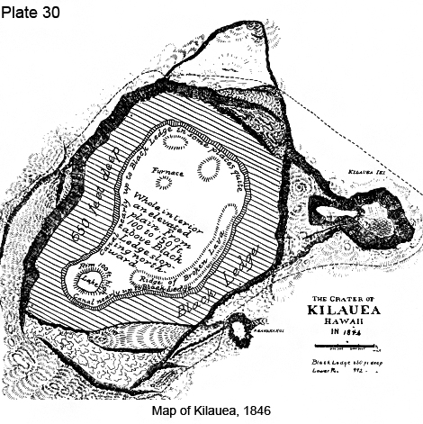
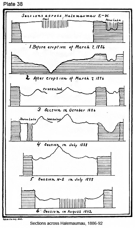
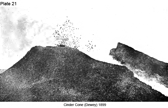

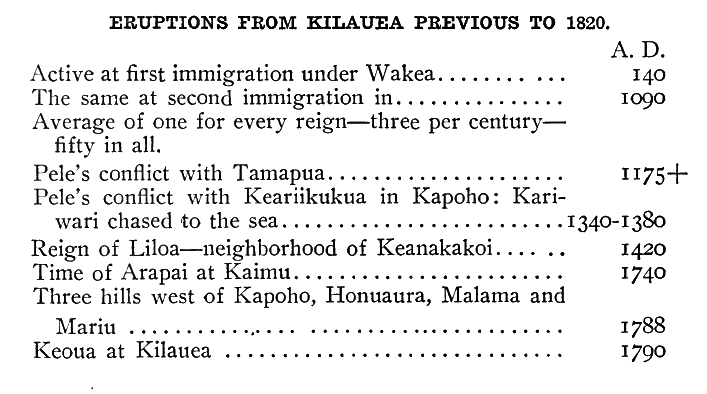
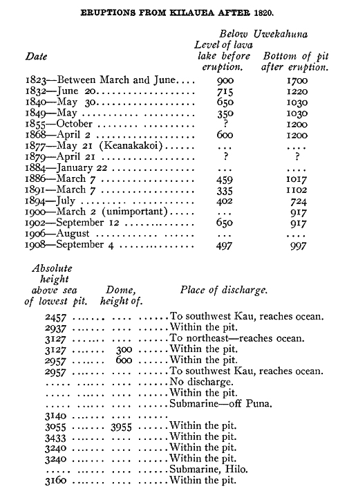

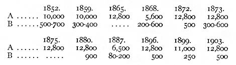
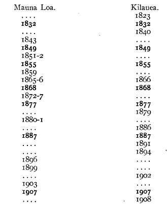
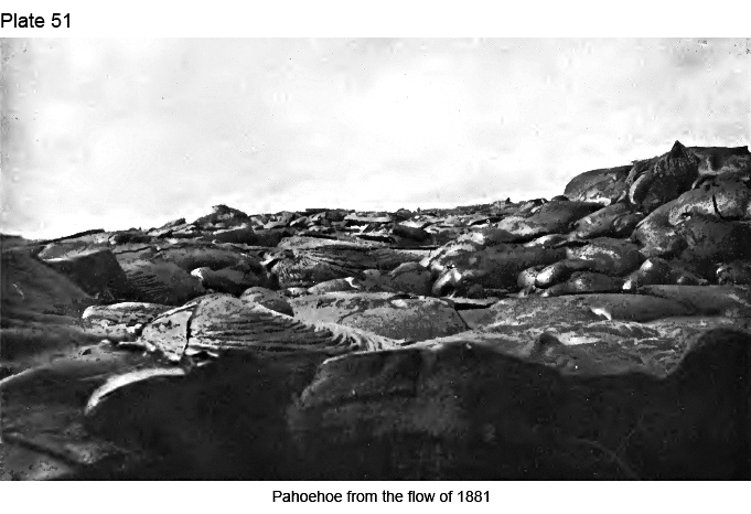
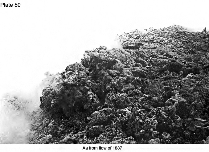
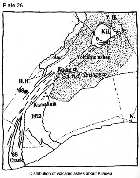
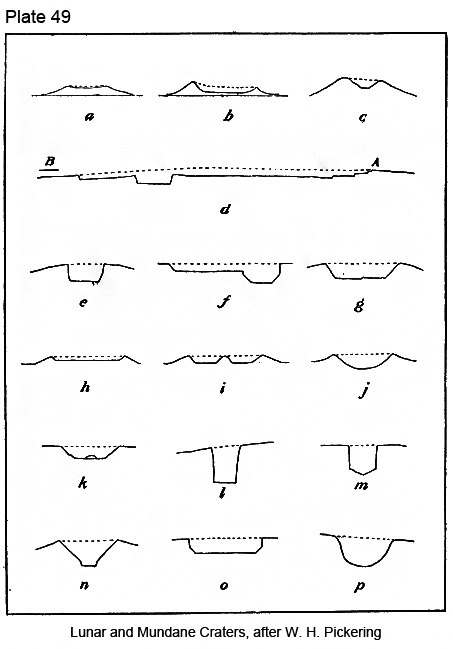
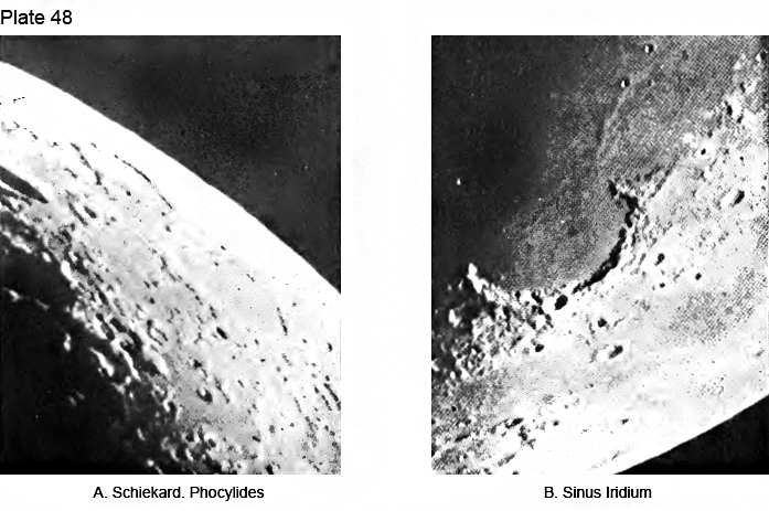
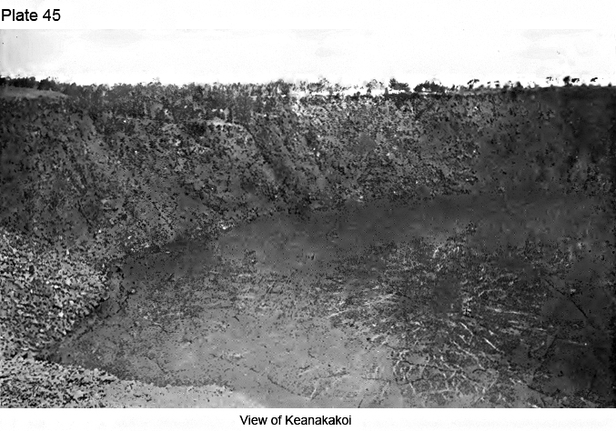
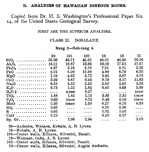

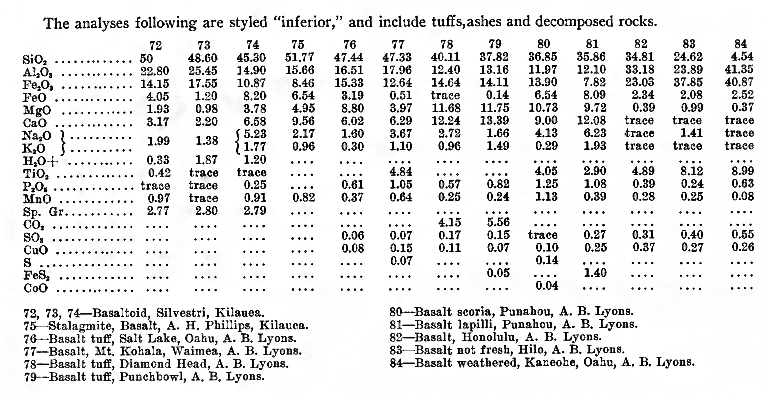
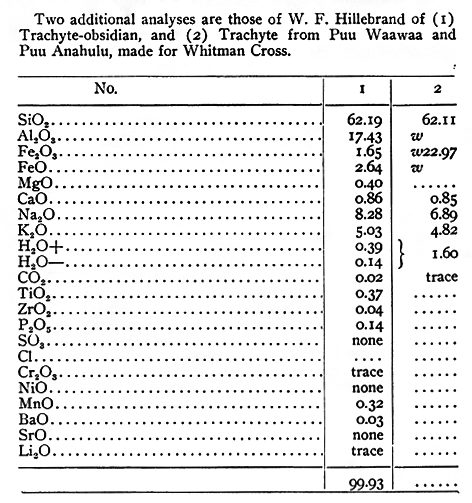
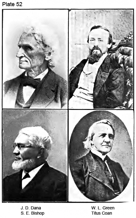
|
|
|
|
|
|
||
| History | Atlas | Culture | Language | Links |