Hawai`i and Its Volcanoes
|
Hawaii and Its Volcanoes by Charles H. Hitchcock, LL.D. of Dartmouth College EARTH SCIENCES LIBRARY, COPYRIGHT, 1909 BY THE HAWAIIAN GAZETTE Co., LTD PART 3: The History of the Exploration of Kilauea
Early Records of Activity at Kilauea Distribution of Volcanic Ashes about Kilauea
Eruption Of 1790 General Conclusions Concerning Both Volcanoes The Region of the Discharge of 1840 as Described by Wilkes
Eruption of 1849
Between
1855 and 1868
Kilauea, sometimes written Kilauea, is better known than Mauna Loa because it is more easily visited and has almost always afforded signs of volcanic activity. The altitude of its north bank at the Volcano House is given at 4,040 feet, and is easily reached by good carriage roads from Hilo on the northeast and the port of Honuapo on the southwest, being midway between these two villages. From Hilo there is also a steam railroad for three-fourths of the way, say twenty-five miles out of thirty-one. The ascent is gradual, at the rate of about one hundred and thirty feet to the mile, so that one does not realize that when standing on the brink of the caldera, he is really on the summit of a lofty mountain. There seems to exist data for a belief in a very extensive prehistoric flow from near Kilauea upon the Government road for over twenty miles southeasterly. At the higher 'elevations, from about the twenty-fifth to the thirtieth mile posts upon the Government road, the forest growth is wanting. The same is true of a broad strip of country makai of the trail used by travelers from Hilo to the volcano more than fifteen years ago. This trail, called the "worst road in the world," in my note books of 1883 and 1886, seems to have been located just outside of the forest, that belt which covers most of the country between Hilo and the Volcano. It is a magnificent growth of ohia, tree ferns, vines and other plants, answering to the appellation of jungle. The climatal conditions are favorable to its continuity over the whole of the region between the present forest and Puna; and it is our belief that the absence of vegetation is due to a large lava stream reaching from an older Kilauea to the lower limits of Olaa. There is a belt of the original growth between the caldera and the beginning of the scanty vegetation, from which immense trunks of the "Hawaiian mahogany" are now being obtained for commercial purposes. A recent trip from the ninth mile post out of Hilo on the Volcano road to Pohoiki (Rycroft's) confirmed these conclusions. Near the coast there is a dense growth of the Pandanus or louhala. Higher up it is replaced by various shrubs, especially the guava. The flow of 1840 is still conspicuous by the sparse vegetation upon it, as sufficient time has not yet elapsed to allow the complete disintegration of the basalt into soil and the consequent growth of trees; bushes appear upon the older lavas adjacent. The greater portion of this road between the flow of 1840 and the ninth mile post is situated upon a barren tract of pahoehoe, if possible more devoid of vegetation than the later stream, be cause Jess easily disintegrated. I found two small areas of the original dense forest in the midst of this barren tract. One is a mile in diameter, east of Pahoa post office; the other is much smaller, near the eighteenth mile post. Large ohias, tree ferns, ropy vines and various shrubs are as vigorous in these islands as in the upper forest, while the interspaces exhibit chiefly the pahoehoe, barren and devoid of vegetation. They are like the outliers of sandstone isolated in a flat country, and supposed to have once covered the whole region. The natural conclusion here is that the forest originally covered the whole of Puna and that a powerful flow of lava came from the barren tract east of Kilauea, burnt its way through the forest, leaving here and there islands of jungle. The general absence of vegetation would indicate that the date of the outflow is comparatively modern, recent enough to have been witnessed by the Hawaiians, and possibly preserved in legendary form. The first known reference to this volcano in the writings of Europeans is that given by Vancouver in 1794. Under date of January 11th, he writes: "As we passed the district of Opoona, (on ship board) the weather being very clear and pleasant, we had a most excellent view of Mauna Loa's snowy summit, and the range of lower hills that extend toward the east end of Owyhee. From the tops of these, about the middle of the descending ridge, several columns of smoke were seen to ascend, which Tamaahmaah and the rest of our friends said were occasioned by the subterranean fires that frequently broke out in violent eruptions, causing among the natives such a multiplicity of superstitious notions as to give rise to a religious order of persons, who perform volcanic rites, consisting of various sacrifices of the different productions of the country, for the purpose of appeasing the wrath of the enraged demon." Menzies in his sketch of the ascent of Mauna Loa refers to the "Volcano," from which smoke and ashes proceeded, making the air thick and irritating to the eyes. This was between Punaluu and Kapapala and his experiences were such as have been repeated constantly ever since. Before citing the account of the next visit to the volcano by an European, it will be well to state what has been learned from the native Hawaiian records, partly historic and partly legendary. Back to Contents Early Records of Activity at Kilauea As is well known, the first detachment of American missionaries arrived in Hawaii in 1820. They gradually made themselves familiar with the island and discovered the fact of the existence of the volcano of Kilauea. Because the natives possessed no written literature, it has been generally understood that their oral traditions transmitted from generation to generation had no scientific value. Historians have discovered that these traditions are of importance in determining the ancestry of the Hawaiians, and to some extent their chronology; and therefore credence may be given to their statements about volcanic activity. They imagined that the volcano was inhabited by certain deities, and rep resented that there were struggles among them and that they had the power to produce flows of lava, both superficially and by underground passages from the crater to the ocean. It may be said that these traditions represent the conceptions formed by the natives of the nature of the eruptions; and consequently the deeds performed can be recognized in one or another phase of volcanic activity. Furthermore, the events are said to have taken place during the reigns of particular kings and therefore make known the date of certain definite eruptions. I have not been able to investigate this history thoroughly, but have gleaned a few facts which may be added to by experts. The first information afforded by the missionaries is contained in a journal of a tour of exploration undertaken in 1823. Rev. William Ellis was an English missionary who had resided for several years in the Society Islands and had acquired a knowledge of the language of that part of the Pacific, which is very much like the Hawaiian tongue. With Rev. Daniel Tyerman and George Bennett, Ellis had explored some of the South Seas. The Hawaiian authorities invited Mr. Ellis, together with two Tahitian chiefs, to reside in Hawaii. The American Board of Commissioners of Foreign Missions took advantage of the opportunity afforded by the presence of these gentlemen to undertake the exploration of the island of Hawaii, primarily for evangelistic purposes, and incidentally for the acquisition of any knowledge of general importance. The missionaries connected with the A. B. C. F. M. who were associated with Mr. Ellis, were Reverends Asa Thurston, Artemas Bishop and Joseph Goodrich, and Mr. Harwood, an intelligent mechanic. All except Mr. Ellis arrived at Kailua, Hawaii, June 26, 1823. Before the arrival of Mr. Ellis, eight days later, the company had discovered various signs of volcanic structure, and attempted the ascent of Mauna Hualalai, but failed to reach the summit, for want of supplies. Back to Contents
Distribution of Volcanic Ashes about Kilauea At length the journey around the island was commenced, and numerous references were made to volcanic phenomena, which need not be repeated. They journeyed through Kona and Kau till Kilauea was reached. They noted the conical hills of volcanic ashes not far from Tairitii, near Kahuku, which we now recognize as a part of the deposit blown out from Mokuaweoweo in prehistoric times. After passing the South Cape they began to see the clouds of smoke and to smell the fumes of sulphur emanating from Kilauea. From Kapapala they diverged on a side trip to Ponahohoa, a distance of five miles, where they saw the discharge that came from Kilauea in the month of March. The story was that the goddess of Pele had issued from a subterranean cavern and overflowed the lowlands of Kapapala. The inundation was sudden and violent. One canoe had been burnt and four others carried out to the sea. At Mahuka the deep torrent of lava had transported a huge rock, nearly one hundred feet high, into the water which was still visible. The ground at Ponahohoa exhibited several chasms, some of them ten or twelve feet across, from which smoke and steam was issuing. The vegetation had been scorched, and a considerable heat was still emanating from the recently ejected lava. This is the only notice we have of the 1823 eruption from Kilauea. In Plate 26 may be seen a sketch of its position and area, party of aa and partly of pahoehoe, occupying a space about fifteen miles square and surrounding the small hills known as Kearaarea. The plan is taken from the recent survey of Kapapala by E. D. Baldwin and George F. Wright, executed under the direction of Walter E. \Nail, Government surveyor. These small craters must have been formed long before this eruption, otherwise their names would not have been known. I have never seen any account of them, but they are quite conspicuous as seen from the Kau volcano road. After reaching Kaimu, several miles east of Kilauea, the deputation listened to accounts of an earthquake which had been experienced about two months earlier. The ground after several minutes of quaking had been rent for several miles in the direction north-by-east, and emitted a quantity of smoke, ashes and luminous vapor, but none of the people were injured. One house was situated directly over the chasm and the people were disturbed in their slumbers. Probably this disturbance was connected with the general eruption of 1823 from Kilauea. After Kilauea had been visited Mr. Ellis questioned the natives about its history. They represented that it had been burning from time immemorial: it often had boiled up and overflowed its banks in the earlier ages, inundating the surrounding country; but for many reigns past it had kept below the level of the surrounding plain, continually extending its surface, increasing its depth, occasionally throwing up large rocks and red-hot stones. These eruptions were always accompanied by dreadful earthquakes, loud claps of thunder and quick succeeding- lightning. No great eruption had taken place since the days of Keoua (1790), but many places near the sea had been overflowed; the streams of lava had taken subterranean courses to the shore. The first incoming of immigrants, as corroborated and dated by the historian Fornander, was in the days of Wakea, A.D. 190, when the volcano was active. The later immigration dates from A.D. 1090; and it was claimed that eruptions had taken place during every reign since that date; which may be estimated as once for every generation. The legend of Pele, detailed later, relates clearly to an eruption from Kilauea, which must have taken place a few years after 1175. About fourteen generations back, in the days of Liloa, 1420, a violent eruption broke out from Keanakakoi. As this seemed to be well known to the natives, it was probably of unusual importance, and is referred to again later. There was also an eruption at Kaimu in the days of Alapai, whose date proves to be from 1730 to 1754, according to Professor W. D. Alexander. Another tradition relates to the disturbances at Kapoho, a very interesting crater in Puna near the eastern extremity of Hawaii, belonging to Mr. Shipman, who entertained me in 1883, and later, to Mr. H. J. Lyman, whom I visited in 1899. Kapoho signifies the sunken in. It is the largest of all the craters in Puna, one mile in diameter, enclosing two hills and a pond of clear water, which is said to be quite saline. Inasmuch as Pele is represented as coming here to engage in the game of holua, it seems probable that Kapoho is connected with Kilauea. It was in the reign of Keariikukii, an ancient king of Hawaii, that Kahavari, a chief from Puna, with others, came to Kapoho to amuse themselves with sliding downhill. Many people came to witness the game, among them Pele. She challenged Kahavari to slide with her, and she was beaten. She asked for his sledge, which he refused to give her. Becoming incensed, she stamped upon the ground, whence followed an earthquake, rending the hill in sunder; and in response to her call liquid fire made its appearance, and pursued Kahavari. He had great difficulty in making his escape down the hill to the sea, whence he was closely followed by fire and stones while his family were overwhelmed. The special site of this action was the crater Kukii, a crater of black and red lapilli half a mile northeasterly from Lyman's. The scoriae are pumiceous like that on the south side of Kilauea. The time of Kahavari's domination in Puna is placed by Kalakaua at A.D. 1340 to 1380, in the resign of Kahoukapu. Another eruption was described by the natives as having been manifested about thirty-five years earlier, say 1788. There are three hills contiguous to each other, to the west of Kapoho, Honualula, Malama (Puulena) and Mariu (Kaliu). These arrested the progress of an immense torrent of lava which inundated the country to the north. This flow must have been analogous to the later discharge from Kilauea in 1840. One cannot resist the impression that the earlier eruptions were comparable with what are called the Vesuvian or explosive type of action; and Plate 27A is a humble attempt to represent the conditions attending the discharge of vapors, stones and ashes, when the whole adjacent region was covered with the ejectamenta. Back to Contents Eruption Of 1790 The account of the eruption of 1790 was compiled by Rev. Sheldon Dibble in his History of the Sandwich Islands, published at Lahainaluna in 1843. He interviewed several of the survivors of the catastrophe, and was able by repeated questionings to compile a satisfactory account of the events. It was also given by Mr. Ellis in his Journal. Rev. H. R. Hitchcock puts the date of the event at November, 1790, in the chronology of Hawaiian happenings appended to his Dictionary: others had supposed it to be a year earlier. In the earlier months of 1790 violent battles had been fought between Keoua and Kamehameha in their struggle for the supremacy, and now quite a large detachment of warriors were on the way to Kau under the leadership of Keoua, an immediate descendant of Taraiopu, a chief mentioned in Captain Cook's narrative. He took the route upon the southeast side of Kilauea and was encamped near Keanakakoi. The natives explained the disaster by the friendship of Pele for Kamehameha and hostility to Keoua. Soon after sunset there were repeated earthquakes, the rising of a column of dense black smoke followed by the most brilliant flames, and streams of lava spouted up in fountains and immense rocks were ejected to a great height. A volley of smaller stones thrown with great force followed the larger ones, striking some of the soldiers, and bursting like bomb shells, accompanied by lightning. Many of the people were killed by the falling fragments and others were buried beneath masses of scoriae and ashes. The natives did not dare to proceed. On the second and third nights there were similar disturbances. Not intimidated by this event Keoua continued his march, separating for safety into three companies. The advance party experienced a severe earthquake and a dense cloud rose out of the crater accompanied by electric discharges. The cloud excluded the light of day, but the darkness became more terrible because of the glare of the red-hot lava below and the flashes of lightning above. Soon afterwards there was a destructive shower, extending for miles around, of sand and cinders. A few persons were burned to death and others were seriously injured. All experienced a suffocating sensation and hastened on as rapidly as possible. The hindmost company which was nearest to the volcano seemed to suffer the least, and hastened forward after the eruption, congratulating themselves upon their escape. On reaching their comrades of the second company, said to be four hundred in number (Ellis says eighty), they were greatly surprised to find them all dead, although they retained life-like postures. Not one of the party survived, except a lone pig. The suddenness and totality of the destruction reads like the story of the disaster at Martinique, pouring down from Mont Pele; especially as Dibble adds: "A blast of sulphurous gas, a shower of heated embers, or a volume of heated steam would sufficiently account for this sudden death. Some of the narrators, who saw the corpses, affirm that though in no place deeply burnt, yet they were thoroughly scorched.” On their return, after the final battle in Kau, in about ten days’ time, the bodies were still entire and showed no signs of decay except a hollowness of the eyes. They were never buried, and one of the missionaries is reported to have seen many years afterwards a human skull lying in the volcanic sand Keoua himself surrendered to Taiana upon the hill of Makanao, one of the buttes in Hilea, described in connection with the caldera of Mohokea. It has been tacitly assumed that the place where the soldiers were destroyed was near Kilauea. The question arises would not the party have taken the regular road from Puna to Kau. If so, they would have been situated about five miles south from Kilauea. This trail is indicated upon Plate 26 by the dotted line leading from the east border of the map to the sand dunes, close by Koae and thence to the Halfway House. The first part of this trail follows a fault line. It would seem not improbable that the eruption came from some vent now concealed from view, because of the distance from Kilauea; but if all the material indicated upon the map as ashes and tuff came out in 1790, there could be no doubt as to its calamitous effect upon the army, for there is an enormous deposit of volcanic ashes, pumice, scoriae, lava bombs, stones and rocks spread over several miles between Keanakakoi and the road from Puna to Kau. It must be scores of feet in thickness. Were it removed; who knows how much farther the caldera beneath extends to the south and southwest!
This deposit must have been laid down by an eruption of the most violent type in prehistoric times long before the passage of the troops of Keoua from Hilo to Kau in 1790. It was a truly terrific discharge, fully equal to anything ever sent out from Vesuvius; and this enables us to affirm that Kilauea has sometimes belonged to the explosive class of volcanoes and has not always been the tame creature of today. Professor J. D. Dana explored the same region in 1887, and was fully persuaded that the material thrown out was connected with the historic event of 1790. "The distribution of the ejected stones, ashes and scoria all around Kilauea seems to show that the whole bottom of the pit was in action; yet the southern, as usual, most intensely so." The heavy compact basalts and their large use indicate that the more deep seated rocks along the conduit of the volcano had been torn off by the violent projectile action. "It was an explosive eruption of Kilauea such as has not been known in more recent times." Professor Dana observed three varieties of volcanic products about Kilauea that seemed to have been ejected explosively from the crater. At the base from twenty to twenty-five feet of yellowish brown tuff including very fine sand well exposed to view near fissures. Above the tuff are two or three feet of coarse conglomerate, including large stones; and on the summit twelve to sixteen inches thickness of a brownish sponge-like scoria, analogous to pumice, in pieces from half an inch across to two or three inches. Less than two per cent of this scoria is solid: it is a network like thread lace. One solid inch of the basalt glass would make a layer of scoria sixty inches thick. Because of its lightness it will float in water and may be easily carried off by the wind. It is most abundant south and west from the volcano; and may be seen near Uwekahuna and at the Volcano House. The stones are about the Volcano House and to the south of the caldera. Towards Keanakakoi, the ejected stones of one and two cubic feet are common; others are larger. The largest one seen contained one hundred cubic feet, and must weigh over eight tons. Stones like this are conspicuous from one-eighth to one-half a mile away from Kilauea. Some of them have been observed upon Uwekahuna. They consist of the more solid basalts of the neighborhood, usually of a gray color and somewhat vesicular. Some carry olivine and all appear to belong to early periods of formation. The tuffs and many stones make up the bulk of the cliffs to the south of the caldera. The recent (1907) map of Kapapala shows finely the distribution of this eolian deposit to the south and southeast. Not less than twenty square miles have been covered by it; extending for five miles southerly and southwesterly, or as far as to the ancient cone of Koae. There are several volcanic cones such as Kearaarea or Kamakaia in the midst of extensive fissures, both old and new. To the south of Koae are many large sand dunes that have been blown from the ash accumulations. On the other side of the fissures as one follows the regular road to Kau from Kilauea for nearly four miles, there are numerous patches of fine-grained drab tuff from two or three to six or more inches in extent with scoriaceous pieces and pisolitic spherules which are less conspicuous than the others, but of the same general character and age. Similar materials may be seen at the saw mill for koa lumber two miles from the Volcano House, and for four or five miles towards Glenwood, so that he entire area covered by the debris of explosive eruptions is estimated at more than sixty square miles. They are six feet thick in the new road around Kilauea iki. The following section has been made out: At the surface, small gravel stones with soil; Gravel two feet thick; Sand, becoming black below; Another foot thickness of sand; Pumice, a few inches thick, sometimes in pockets ; Rubble stones, some as large as cobbles; Underlying rock. The black seams are suggestive of a vegetable growth, indicating a lengthy period when plants were able to spread naturally from ,the surroundings, only to be covered later by the volcanic rain. The enormous area thus covered with explosive material renders it probable that the comparatively mild discharge of 1790 was inadequate to account for so extensive an inundation. There must have been several such discharges, perhaps recurring during centuries of time. Only a tithe of the stones spread over the surface would have been needed to destroy a much larger detachment than that suffocated in 1790. It would seem more consonant with the facts to connect the prolific tuffaeous and scoriaeous discharges with the days of Liloa rather than of Keoua; and perhaps Keanakakoi may have been the vent through which the discharge came. Certain observations made in 1905 may be significant here: Opposite Keanakakoi in the pit of Kilauea there was formerly exhibited upon the maps a "sulphur bank," now mostly covered by the black ledge. A narrow promontory still extends westerly to the south of Halemaumau, terminating at Kapuai and only slightly elevated, and covered with eolian debris. At the southwest end of the wall from Poli o Keawe there is an abrupt change from basalt to scoriae, and as you climb to this rock from the gravel a marked fault appears with a S.W. direction. On looking backwards there is a noticeable dip of the layers towards the old sulphur bank-perhaps of ten degrees. The fault seems to be the same with that figured by Professor W. H. Pickering. It seems apparent that the tuffs came from Keanakakoi, unless they represent the inward slope of the material blown out from Kilauea, such as falls toward the vent in tuff cones. Most of the cliff encircling the south curve of Kilauea is composed of similar materials. Dr. Brigham speaks of several shallow pits in this tuff that were made by the falling down or washing into fissures the finer parts of the sand and gravel. All these facts impress one with the magnitude and unusual character of the materials erupted about Keanakakoi. While there has been uncertainty about the date and origin of the various Kau accumulations of dust, it is refreshing to be able to present the views of Mr. E. D. Baldwin, obtained recently as the result of his survey for the Kapapala map. He finds that much of the fine volcanic ash has been derived from a Kilauean source; while there were earlier discharges in lower Kau and at Ka Lae not thus accounted for. These have been mentioned elsewhere in connection with the history of Mauna Loa. Back to Contents E. D. Baldwin upon the Yellow Ashes of Kau As to the sources of the yellow ash eruption, I would state, that I found a partial old yellow cone in among the Kamakaia hills, or the hills some three miles back of the Halfway House. The first source of the 1823 flow was three miles above these hills, from a long fissure, and then it seems to have broken out again, in its line of flow at these hills, forming the two larger cones. Near the large cone are two ancient cones, surrounded by the new lava, one of these was completely spattered and plastered over by the ejections from the large cone; it was on this cone, while riding along its base, that my horse broke through the crust, and while floundering around for a footing brought up large quantities of yellow tufa, of exactly the same nature as the black tufa, only it was of a beautiful yellow ocher color. On investigation I found that a large portion of this cone was composed of the same material. About a mile below Kamakaia hills, in the middle of the 1823 flow, is what we call the yellow cone. This cone had attracted my attention several times from a distance, as being of a yellowish color on all sides that we had observed it from. I thought, of course, that like the little sharp cone, Puu Kou, between it and the Kamakaia hills, it was a portion of the 1823 lava flow, but when we went out to the cone, we found that it was the top of an old cone sticking up through the 1823 flow, which flow had run all around the same, and into the crater of the cone. This cone was very interesting, its formation was exactly the same as all of the dark colored tufa cones, with the exception of color, which was entirely of the yellow tufa, which, when crushed in the hand to fine powder, had exactly the same appearance as the Kau yellow soils. In the crater of the cone were the same brilliantly red tufas that you find in the craters of all other cones. The top of the cone stands forty or fifty feet above the 1823 flow, and must be several hundred feet in circumference at the flow line. At this point the land lays more or less level, with a gentle slope towards the sea, so that the 1823 flow seems to have piled up to a great height and spread out to over a mile wide; showing that this was a very large cone in its original state. There are further evidences of the yellow eruptions some ten miles from these cones mentioned above. The great hill Puu Kapukapu, at the sea coast, is largely composed of the Kau yellow soil, also just to the Kau side of this hill, is the great hill Puu Kaone, having a low flat top, containing sixty acres of first class agricultural land, composed entirely of the Kau yellow soil of a depth of over thirty feet, as observed in the little rain-washed gullies on the same. Also on the face of the great pali or fault line, near the top, on a line towards Kamakaia hills from Puu Kapukapu, I noticed a large yellow patch. None of the sources of the yellow eruptions, that I have mentioned, would account for the lower Kau yellow soil, and that on the Kau side of Ka Lae or South Point, as the prevailing winds in this district seem to sweep from the volcano (Kilauea) down past the Kamakaia hills, and from there they meet the winds coming around from the sea coast, which seem to turn the air currents inland again. My theory is, that at some ancient period, there was a great line of yellow eruptions, extending from Puu Kapukapu (near Keauhou), past the Kamakaia hills to the lower portion of Kau, and that the sources of this yellow eruption in the lower part of Kau have been covered up with later flows, or other volcanic action, and that the great beds of yellow soil that we find today all over Kau, were blown there from these sources, before they were covered up. All of the yellow soil on the Pahala plantation, or towards the volcano from Pahala, is directly on the line of the prevailing winds from the direction of Kamakaia hills, Yellow cone, and a short ways below the same. I have especially noticed in the cuts on the Volcano-Kau road, just above the Pahala mill, that the old aa formation seems to be full of this yellow dust. If one will go and study the action of the wind on the great masses of volcanic sand being blown, at present, from Kilauea towards Kamakaia hills, it will be noted that when this sand strikes an aa flow, its forward progress is stopped, until it has filled and sifted into all of the little crevices of the aa. From Kilauea to near Kamakaia hills is a nearly barren field of pahoehoe, and the sand is driven along this space at a great pace, until it reaches the aa at the Kamakaia hills, and there it has been blocked up and is in many cases forming numerous sand dunes. Some of these sand dunes are very extensive, being four or five hundred feet long and over fifty feet high. Back to Contents Ellis' Description of Kilauea The first edition of the Journal of the Tour Around Hawaii was published in 1825. Eight years later it was reprinted with additions and emendations as Polynesian Researches, in four volumes and some of the original statements were modified. There were English editions also. I will utilize the additions and corrections given in the later edition. "We found ourselves," he says, "on the edge of a steep precipice (Uwekahuna) with a vast plain before us, seven and one-half miles in circumference, and sunk at least eight hundred feet below its original level. The surface of this plain was uneven, and strewed over with large stones and volcanic rocks. A place was found at the north end where a descent to the plain below was found practicable, and even yet the stones gave way under their feet causing them to fall and receive bruises. The rocks were of a light red and gray lava, vesicular, and lying in horizontal strata, varying in thickness from one to forty feet. In a small number of places the different strata of lava were also rent in perpendicular or oblique directions, from the top to the bottom, either by earthquakes or other violent convulsions of the ground connected with the action of the adjacent volcano. The immense gulf has the form of a crescent two miles long from northeast to southwest and a mile in width. The bottom was covered with lava, and the southwest and northern parts of it were one vast flood of burning matter, in a state of terrific ebullition, rolling to and fro its "fiery surge" and flaming billows. Fifty one conical islands (spiracles), of varied form and size, containing as many craters, rose either round the edge or from the surface of the burning lake. Twenty-two constantly emitted columns of gray smoke or pyramids of brilliant flame; and several of these at the same time vomited from their ignited mouths streams of lava, which rolled in blazing torrents down their black indented sides into the boiling mass below." Next follows a paragraph added in the later edition, a theoretical deduction. "The existence of these conical craters led us to conclude that the boiling caldron of lava before us did not form the focus of the volcano; that this mass of melted lava was comparatively shallow; and that the basin in which it was contained was separated, by a stratum of solid matter, from the great volcanic abyss, which constantly poured out its melted contents through these numerous craters into this upper reservoir. We were further inclined to this opinion from the vast column of vapor continually ascending from the chasms in the vicinity of the sulphur banks and pools of water, for they must have been produced by other fire than that which caused the ebullition in the lava at the bottom of the great crater; and also by noticing a number of small craters in vigorous action, situated high up the sides of the great gulf, and apparently quite detached from it. The streams of lava which they emitted rolled down into the lake and mingled with the melted mass, which, though thrown up by different apertures, had perhaps been originally fused in one vast furnace.'' "The sides of the gulf before us, although composed of different strata of ancient lava were perpendicular for about (nine) hundred feet (as calculated by Lieut. Malden later) and rose from a wide horizontal ledge of solid black lava of irregular breadth, but extending completely round. Beneath this ledge the sides sloped gradually towards the burning lake, which was, as nearly as one could judge, three or four hundred feet lower. It was evident that the large crater had been recently filled with liquid lava up to the black ledge, and had by some subterranean canal emptied itself into the sea, or upon the lowland on the shore." And he goes on to suggest that this discharge was what they had seen at Ponahoahoa a short time previously. This eruption is reported at one time two moons and at another five moons earlier than that date of August 1st. I have already presented a figure illustrating this flow to the southwest. It has been difficult to be entirely satisfied with some of the details offered in this sketch, because of repetitions, and of differences in the accompanying sketches. The first are explained by the supposition that to the original statement additions were made by others of the party; and the second may be due to the artist or engraver who make changes to suit fancy. The earlier account of all the Hawaiian volcanoes have been more or less influenced by a supposed similarity to Vesuvius. Instead of reproducing the sketches, I will present a restoration of what seem to me to be the true delineation of the cliffs, the black ledge and the lakes of fire, as they appeared in 1823, Plate 27B. The verbal description of the volcano given above by Mr. Ellis represents things as seen from Uwekahuna, but the views published must have been taken from the opposite side of the pit, showing the place on which he stood when he obtained his impressions. The descriptions of the two sulphur banks correspond to what have been seen later by others. The one at the north end was said to be about one hundred and fifty yards long, and thirty feet high at the maximum, showing much sulphur mixed with red clay. The ground was hot; fissures seamed the surface through which thick vapors continually ascended. Fine crystals of sulphur appeared in acicular light yellow prisms near the surface; those lower down were of an orange-yellow color in single or double tetrahedral pyramids an inch long. Ammonium sulphate, alum and gypsum frequently incrusted the stems. The other sulphur bank was larger and the sulphur more abundant, but they did not find time to examine it carefully. Both these banks correspond to what is now called a solfatara. The view by night was impressive. "The agitated mass of liquid lava, like a flood of melted metal, raged with tumultuous whirl. The lively flame that danced over its undulating surface, tinged with sulphureous blue, or glowing with mineral red, cast a broad glare of dazzling light on the indented sides of the insulated craters, whose roaring mouths, amid rising flames and eddying streams of fire, shot up, at frequent intervals, with very loud detonations, spherical masses of fusing lava or bright ignited stones." Mr. Ellis correctly named the rock, calling it basalt containing fine grains of feldspar and augite, with olivine. He also found zeolites and described the volcanic glass called Pele's hair by the natives. He conceived it to have been produced by a separation of fine spun threads from the boiling fluid, and when borne by the smoke above the edges of the crater had been wafted by the winds over the adjacent plain. He examined several of the small craters, which from above had appeared like mole hills, and found them to be from twelve to twenty feet high. The outside was composed of bright shining scoria and the inside was red with a glazed surface. He also entered several tunnels through which the lava had flowed into the abyss, and correctly ascribes their origin to the formation of the roof and sides by the cooling of the exterior, while the liquid for a time continued to flow in the inside. Professor Dana thinks that the fan figured on the west wall in the first sketch of the south end of the volcano was one of these tunnels, but it seems to me that it was only a fan of gravelly scoriae. It appeared as an isolated cone in the second sketch, detached from the wall, probably because the engraver did not know what else to do with it. Dr. S. E. Bishop tells me that this fan was very conspicuous when he first visited the volcano seventy years ago, and at his suggestion I looked for it in 1905 and could identify its location. Probably the tunnels were upon the eastern side, where later flows, such as those made in 1832, are still in evidence. These tunnels were represented as being hung with red and brown stalactitic lava, while the floor appeared like one continued glassy stream. The riffle of the surface was as well defined as if the lava had suddenly stopped and become indurated before it had time to settle down to horizontality. It would appear from what has been stated that there was more than one lake of fire at this time, and that there was a great abyss into which the surplus lava from the higher lake and the streams through the tunnels had accumulated. Mr. Ellis also speaks of the two side craters Keanakakoi and Kilauea iki, thus proving that these names were in use in 1823, and he seems to have been the originator of the expression "black ledge," which represented the level assumed by the molten lava before the recent discharge to the southwest. He speaks of many masses of grey basaltic rock, weighing from one to four and five tons, and surmised that they had been ejected from the great crater during some violent eruption. Not to present more of his truthful descriptions, I will refer only to his final speculation of the extent of the present subterranean fires. The whole island of Hawaii was said to be "one complete mass of lava, or other volcanic matter in different stages of decomposition. Perforated with innumerable apertures in the shape of craters, the island forms a hollow cone over one vast furnace, situated in the heart of a stupendous submarine mountain, rising from the bottom of the sea," etc. Back to Contents The Belief in Pele The apprehensions uniformly entertained by the natives of the fearful consequences of Pele's anger prevented their paying very frequent visits to the vicinity of her abode; and when, on their inland journeys, they had occasion to approach Kilauea, they were scrupulously attentive to every injunction of her priests, and regarded with a degree of superstitious veneration and awe the appalling spectacle which the crater and its appendages presented. The violations of her sacred abode, and the insults to her person, of which we had been guilty, appeared to them, and to the natives in general, acts of temerity and sacrilege; and, notwithstanding the fact of our being foreigners, we were subsequently threatened with the vengeance of the volcanic deity under the following circumstances. "Some months after our visit to Kirauea, a priestess of Pele came to Lahaina, in Maui, where the principal chiefs of the islands then resided. The object of her visit was noised abroad among the people, and much public interest excited. One or two mornings after her arrival in the district, arrayed in her prophetic robes, having the edges of her garments burnt with fire, and holding a short staff or spear in her hand, preceded by her daughter, who was also a candidate for the office of priestess, and followed by thousands of the people, she came into the presence of the chiefs; and having told who she was, they asked what communications she had to make. She replied that, in a trance or vision, she had been with Pele, by whom she was charged to complain to them that a number of foreigners had visited Kilauea; eaten the sacred berries; broken her houses, the craters; thrown down large stones, etc. to request that the offenders might be sent away and to assure them, that if these foreigners were not banished from the islands, Pele would certainly in a given number of days, take vengeance, by inundating the country with lava, and destroying the people. She also pretended to have received in a supernatural manner, Rihoriho's approbation of the request of the goddess. The crowds of natives who stood waiting the result of her interview with the chiefs were almost as much astonished as the priestess herself, when Kaahumanu, and the other chiefs, ordered all her paraphernalia of office to be thrown into the fire, told her the message she had delivered was a falsehood, and directed her to return home, cultivate the ground for her subsistence, and discontinue her deceiving the people. This answer was dictated by the chiefs themselves. The missionaries at the station, although they were aware of the visit of the priestess, and saw her, followed by the thronging crowd, pass by their habitation on the way to the residence of the chiefs, did not think it necessary to attend or interfere, but relied entirely on the enlightened judgment and integrity of the chiefs, to suppress any attempt that might be made to revive the influence of Pele over the people; and in the result they were not disappointed, for the natives returned to their habitations, and the priestess soon after left the island, and has not since troubled them with threatenings of the goddess. "On another occasion, Kapiolani, a royal princess, the wife of Naihe, chief of Kaavaroa, was passing near the volcano, and expressed her determination to visit it. Some of the devotees of the goddess met her and attempted to dissuade her from her purpose; assuring her that though foreigners might go there with security, yet Pele would allow no Hawaiian to intrude. Kapiolani, however, was not to be thus diverted, but proposed that they should all go together; and declaring that if Pele appeared, or inflicted any punishment, she would then worship the goddess, but proposing that if nothing of the kind took place, they should renounce their attachment to Pele, and join with her and her friends in acknowledging Jehovah as the true God. They all went together to the volcano; Kapiolani, with her attendants, descended several hundred feet towards the bottom of the crater, where she spoke to them of the delusion they had formerly labored under in supposing it inhabited by their false gods; they sang a hymn, and after spending several hours in the vicinity, pursued their journey. What effect the conduct of Kapiolani, on this occasion, will have on the natives in general, remains to be discovered." Back to Contents
KAPIOLANI
(Kapiolani was the daughter of Keawemauhile, the former king of Hilo,
slain by Keoua in 1790.) When from the terrors of nature a people Have fashioned and worshipped a Spirit of Evil, Blest be the voice of the teacher who calls to them, "Set yourselves free!"
Noble the Saxon who hurled at his idol A valorous weapon in olden England! Great, and greater, and greatest of women, Island heroine, Kapiolani, Clomb the mountain, and flung the berries, And dared the Goddess, and freed the people Of Hawaii! This people – believing that Pele the Goddess, Would swallow in fiery riot and revel On Kilauea, Dance in a fountain of flame with her devils, Or shake with her thunders and shatter her island, Rolling her anger Through blasted valleys and flowing forest In blood-red cataracts down to the sea!
Long as the lava light glares from the lava lake, Dazing the starlight; Long as the silvery vapor in daylight Over the mountain floats, will the glory Of Kapiolani be mingled with either On Hawaii. What said her Priesthood, "Woe to this island if ever a woman should handle Or gather the berries of Pele! Accursed were she!
And woe to this island if ever a woman Should climb to the dwelling of Pele the Goddess! Accursed were she!" One from the sunrise dawned on His people, And slowly before Him vanished shadow-like Gods and Goddesses, None but the terrible Pele remaining, As Kapiolani ascended her mountain, Baffled her priesthood, broke the tabu, Descended the crater, Called on the Power adored by the Christian, And crying, "I dare her! Let Pele avenge herself!" Into the flame dashed down the berries, And drove the demon from Hawaii! Back to Contents The True Story of Pele King Kalakaua recovered from the traditions handed down for many generations the true story of Pele, and has presented it in his book under the heading of The Apotheosis of Pele. It seems that there was a large family, five brothers and nine sisters, emigrating from Tahiti during the reign of Kamiole the usurper about A.D. 175. Their names are given by Ellis as follows: Kamohoarii; Tapohaita hiora (the explosion in the place of life); Teuaatepo (the rain of night); Tanehetiri (husband of thunder or thundering Tane) and Teoahitamatana (fire-thrusting child of war). These were all brothers, two of them like Vulcan being humpbacked. The sisters were Pele, the principal goddess; Makorewawahiwa (fiery-eyed canoe breaker); Hiataholani (heavenrending cloud holder); Hiatanoholani (heaven-dwelling cloud holder); Hiatata aravamata (quick-glancing-eyed cloud holder, or the cloud holder whose eyes turn quickly and look frequently over her shoulders); Hiatahoiteporiopele (the cloud holder embracing or kissing the bosom of Pele); Hiatatabuenaena (the red-hot mountain holding or lifting clouds); Hiatatareia (the weather 'garland-encircled cloud holder); and Hiataopio (young cloud holder). This family with many others in their train settled about Kilauea. Pete was a valiant warrior. Kamapuaa was attracted by the merits of Pele, visiting Kilauea, and made proposals to become her guest and suitor. In many of the annals he is represented as half human and half hog-but Kalakaua explains that he was simply a rough, stalwart man with coarse black bristly hair of unprepossessing appearance, and called a half hog in derision. Pete rejected his proposals with contempt, calling him a hog and the son of a hog. A combat ensued, and the Pele family were worsted, and retreated to one of the long volcanic tunnels marking the course of an earlier lava flow ,and the entrance was closed. The party consisted of two men and eighteen women and children. Kamapuaa finally discovered the retreat and dug down into it from above. Just then there came a flow of lava which drove away the besiegers, who believed the people within the cave had been destroyed. Because of this timely eruption it was believed that Pele had the power of calling up the fire, and she became apotheosized as a goddess. As time went on the various eruptions were ascribed to some of Pete's movements. The whole island was considered bound to pay tribute; and if the proper offerings were not given to her votaries the caldera would be filled with lava and made to follow the delinquents. Back to Contents Kilauea in 1824 In 1824 Kilauea was visited by E. Loomis, June 16th, who came from the southwest. After reaching a point two miles from the crater he was annoyed by smoke blowing in his face, accompanied by sulphur fumes. The air, too, was filled with fine particles of sand, rendering it necessary to protect his face from their impact; and the surface of the ground was covered by it, his feet sinking into it six or eight inches at every step. From crevices five miles west of the crater smoke was issuing, and occasionally the forced ejection was great enough to produce an irregular hissing sound. At the southwest end of the volcano the smoke was so dense that little could be seen, and farther on much rain fell. He took the road on the east side. From two hundred and fifty to three hundred feet below the edge was a level platform, extending entirely around the crater, which was evidently the "black ledge" of Ellis. This platform was fifteen rods wide where he descended, probably near the "sulphur banks" as now designated. He had little difficulty in reaching the black ledge. Having now descended six hundred feet, Mr. Loomis walked upon the lower platform whose surface was smooth, though not level, rising in heaps like cocks of hay and broken by innumerable fissures. The lava was black, porous like pumice, and traversed by crevices emitting very hot steam. Proceeding eight or ten rods he reached another escarpment of two hundred or three hundred feet deep leading to the floor of the most active portion, from which smoke and flames of fire were issuing. There seemed to be small craters (spiracles) where the fire burst forth attended by a horrid noise. He was quite disappointed in not finding this lowest platform a mass of liquid fire, as it had been the year previous. The surface had become hard, and he presumed he could have walked over it safely but he did not descend to it as the sides were too steep to allow of a comfortable passage. This record is quite important, as it shows a period of comparative quiet at the center of eruption following the intense activity reported by Ellis in the previous year. Back to Contents Visit of Lord Byron In the year 1825, July 28th, a party from the "Blonde" visited the crater, Lord George Anson Byron being the leader. Others were Rev. C. C. Stewart and Lieut. Malden, the historians, and R. Dampier, the artist. The hut used by the company was situated upon the narrow plain between Kilauea and Kilauea iki. It had been erected a year or two earlier for the accommodation of Kapiolani. Lieut. Malden calculated the height of the upper cliff, Uwekahuna, to be nine hundred feet above the black ledge, and the depth of the lower pit at six hundred feet, a total of 1,500 feet. The circumference of the edge of the black ledge was from five to seven miles and that of the top from eight to ten miles Mr. Stewart speaks of the black ledge as a kind of gallery, in some places only a few feet, in others many rods wide. The gulf below contains as many as sixty small conical craters, many in constant action. The tops and sides of two or three of these are covered with sulphur, showing mingled shades of yellow and green. The upper cliffs on the northern and western sides are of a red color. Those on the eastern side are less precipitous and are largely composed of sulphur. The south end was wholly obscured by smoke which was impenetrable. The chief seat of action seemed to be at the southwestern end (Halemaumau). To the north of this is one of the largest of the smaller craters-one hundred and eighty feet high-an irregularly shaped inverted funnel of lava covered with clefts, orifices and tunnels, from which bodies of steam escaped with deafening explosion, while pale flames, ashes, stones and lava were propelled with equal force and noise from its ragged and yawning mouth. On the evening of the following day (29th) after terrific noises and tremblings of the ground, "a dense column of heavy black smoke was seen rising from the crater directly in front of us – the subterranean struggle ceased – and immediately afterwards flames burst front a large cone, near which we had been in the morning, and which then appeared to have been long inactive. Red-hot stones, cinders and ashes, were also propelled to a great height with immense violence; and shortly after the molten Java came boiling up, and flowed down the sides of the cone and over the surrounding scoriae, in two beautifully curved streams." At the same time a lake of molten lava two miles in circumference made it appearance. Rev. Artemas Bishop, in December, states that the pit was not so deep as in 1823 at the time of Ellis' visit by as much as four hundred feet. There were also Jakes of lava, frequently discharging gusts of vapor and smoke with great noise. As an evidence of oft repeated eruptions from Kilauea, the natives remarked to Mr. Bishop, that after rising a little higher the lava would discharge itself towards the sea through some subterranean aperture. Rev. Mr. Stewart visited Kilauea again in October, 1829. The lower pit had been filled up more than two hundred feet, and there was more fire at the northern end. Many of the cones had disappeared, but he was greatly interested in two of them – each one about twenty feet high – tapering from a point above to a base sixty feet in circumference. They were hollow, with steam, vapors and flame issuing from crevices and roaring so as to merit the appellation of "blow holes," or "spiracles," as named by G. Paulett Scrape. Back to Contents Visit of Hiram Bingham Rev. Hiram Bingham spent thirty hours at the volcano October 20th and 21st, 1830. He represented the altitude to be 4,000 feet, ten thousand below Mauna Loa. Six hundred feet below the rim "stretched around horizontally a vast amphitheater gallery of black indurated lava," on which a hundred thousand people might stand. The lake of fire was one thousand feet deep. "The fiercely whizzing sound of gas and steam, rushing with varying force through obstructed apertures in blowing cones, or cooling crusts of lava, the laboring, wheezing struggling, as of a living mountain, breathing fire and smoke and sulphurous gas from his lurid nostrils, tossing up molten rocks or detached portions of fluid lava, and breaking up vast indurated masses with varied detonations, all impressively filled us with awe. "The great extent of the surface of the lava lake; the numerous places on it where the fiery element was displaying itself, the conical mouths here and there, discharging glowing lava over flowing and spreading its waves around, or belched out in detached and molten masses that were shot forth with detonations, perhaps by the force of gases struggling through from below the surface, while the vast column of vapor and smoke ascended up toward heaven ,and the coruscations of the emitted brilliant lava illuminated the clouds that passed over the terrific gulf, all presented by night a splendid and sublime panorama of volcanic action, probably nowhere else surpassed." He descended from the northeast side to the black ledge, and to the lava lake, which "presented cones, mounds, plains, vast bridges of lava recently cooled, pits and caverns, and portions of considerable extent in a movable and agitated state." Near the center is a large mound, from the top of which lava poured out in every direction in a series of circular waves. The outermost wave solidifies, when another one follows, perhaps passing over the first; then others follow as if in a series of pulsations from the "earth's open artery" at the top of the mound. The capillary glass was observed, and its formation understood. "It is formed, I presume, by the tossing off of small detached portions of lava of the consistence of molten glass, from the mouths of cones, when a fine vitreous thread is drawn out between the moving portion and that from which it is detached. The fine spun product is then blown about by the wind, both within and around the crater, and is collected in little locks or tufts." In July, 1831, Mr. Goodrich visited Kilauea and says that "the crater had been filled up to the black ledge, and about fifty feet above it, about nine hundred feet in the whole," since his first visit in 1823. Back to Contents Eruption of 1832 The accounts of the eruption of 1832 are sufficiently full to enable us to know that the disturbances in Kilauea near the lakes of fire correspond to those manifested at other eruptive periods. According to the statements that have already been cited, the lower pit had been filled up with lava to the amount of nine hundred feet since the discharge of 1823. Rev. Joseph Goodrich visited the locality in November and says that the lava "had now again sunk down to nearly the same depth as at first, leaving as usual a boiling caldron at the south end. The inside of the crater had entirely changed. In January – preceding-about the 12th as nearly as I can ascertain – the volcano commenced a vigorous system of operations, sending out volumes of smoke; and the fires so illumined the smoke that it had the appearance of a city enveloped in one general conflagration." A day or two later there were six or eight smart earthquakes, repeated for two or three days. These may have been concerned more particularly with the emissions on the plain between the two craters of Kilauea and Kilauea iki. On descending into the caldera, Mr. Goodrich speaks of the molten lava at the south end – "an opening in the lava sixty to eighty rods long, and twenty or thirty wide." About twenty feet below the brink this liquid mass was "boiling, foaming and dashing in billows against the rocky shore. The mass was in motion, running from north to south at the rate of two or three miles an hour; boiling up as a spring at one end, and running to the other." He speaks of this mass as a lake, and says that the liquid lava is incrusted by its own cooling, just as ice is formed over rivers in cold climates. As the ice in rivers crashes against the shores, so this crust is forced against the bank and distorted. The lava crusts melt and reform while "gaseous matter is forced through, scattering the liquid fire in every direction." There were also two islands in this lake. This, however, must have been after the discharge of the liquid from the bottom of the pit. There is absolutely no testimony from any source, of this eruption, save the statement that it ran away about January 12th. Whether it appeared at the surface, filled up some subterranean cavity or flowed under the sea is entirely unknown. Before its disappearance the lava rose about fifty feet above the black ledge of 1823, thus building up a platform believed to be nine hundred feet above the molten lake. From Mr. Goodrich's statements the depth of the bottom must have been 1,750 feet from the top of the wall. This is confirmed by an entry in the private diary of Rev. W. P. Alexander who visited the volcano January 12, 1833, two months later than Mr. Goodrich, who says the crater was two thousand feet deep. He does not speak of any black ledge; whence it is inferred that this terrace must have been very narrow, as in 1823. Mr. Alexander was disappointed in not finding the principal furnace in lively action while he was at the bottom of the pit; but by the time he had returned to the summit a furious action had commenced and molten lava spouted far into the air with a roaring sound. The following day the boiling caldron was found to be 3,000 feet long, 1,000 wide, and spouting in jets forty or fifty feet high. The manifestations of igneous activity in another part of the area, at this time, January, 1832, as reported by Mr. Goodrich and confirmed by later observations of the effects produced, were unlike any others that have been seen at Kilauea. "The earthquakes rent in twain the walls of the crater on the east side from the top to the bottom, producing seams from a few inches to several yards in width, from which the region around was deluged with lava. The chasms" (were developed) "within a few yards of where Mr. Stewart, Lord Byron, myself and others had slept," the spot being the "Hut" on Malden's map, "so that the spot where I have lain quietly many times is entirely overrun with lava." Back of it, at right angles with the main chasm, and about half way up the precipice, there was a vent a quarter of a mile in length from which the lava issued which had destroyed the Hut. This fissure thus was parallel with the edge of Kilauea Upon Mr. Dodge's map the lava is represented as starting from an orifice below the edge of Poli o Keawe, spreading out like a fan so as to include the Hut, and then turning westerly so as to pour into Kilauea; and there was so much of it that it makes a tongue-like projection into the contour of the lower plain just at the northern end of the sulphur banks. Professor Dana was greatly impressed by the appearance of these cooled and hollow streams, as he saw them in 1840. "The angle of descent of these streams was about thirty-five degrees; and yet the streams were continuous. The ejection had been made to a height of four hundred feet at a time when the pit below was under building lavas and ready for discharge. Elsewhere about the upper walls, and also about those of the lower pit, no scoria was seen. The surfaces of walls are those of fractures, brought into sight by subsidences; and the rocks of the layers were as solid as the most solid of lavas. Moreover, no scoria intervened between the beds of lava even in the walls of the lower pit, each new stream having apparently melted the scoria-crust of the layer it flowed over; and no beds of cinders or volcanic ashes were anywhere to be seen in alternation with the beds of lava. While the cooled lava streams over the bottom were of the smooth-surfaced kind, and would be called pahoehoe, there was the important distinction into streams having the scoria-crust just mentioned, and those having the exterior solid with no separate crust – facts that pointed to some marked difference in conditions of origin." The floor of Kilauea iki is covered by as many as fifty hummocks fifteen or twenty feet high. They arrested the attention of Professor W. H. Pickering in 1905, who conceives them to illustrate the process of construction of Kilauea itself as well as elevations on the surface of the moon. He says, "The surface of the crater floor of Kilauea iki seems to have solidified into a layer six to ten inches in depth and distinct from the portions below it. A liquid core forced up from below raised this surface layer locally, and shattered it into separate pieces like cakes of ice. This core in the case of the smaller craterlets was sometimes only two or three feet in diameter, and could be seen beneath the shattered surface. In one instance its summit seemed to have an almost globular form, five feet in diameter. If the volcanic forces beneath these craterlets had been more intense, it is probable that the issuing lava would have completely destroyed them, forming a series of crater pits into which the lava would have subsequently retreated. In the southwest part of the floor two such pits were found, perhaps fifteen feet in depth by thirty in diameter, down into which a stream of lava had poured, but had solidified without filling them up." Kilauea iki, according to Mr. Dodge's map, is 3,300 feet from east to west and 2,800 feet from north to south, and is seven hundred and forty feet deep, or eight hundred and sixty-seven feet below the Volcano House, from which it is about a mile distant. It is best reached by descending the north wall, making use of ropes in the steepest part of the slope. It is now (1909) encircled by a carriage road from the Volcano House. This was the original name given to it by the natives, iki, meaning little, and was used by Mr. Ellis in his Journal, and by most travelers. Professor Brigham called it Poli o Keawe, and applied the Kilauea iki to Keanakakoi; and was followed by Captain Dutton. On questioning reliable natives in 1883 about the nomenclature, I found that Mr. Ellis was right in his early application of these names, and that the expression Poli o Keawe, signifying the bosom of Keawe, should be applied to the bluff overlooking Kilauea between the two side pits. Keanakakoi was derived from ana, a cave, and koi an axe or adze: meaning a chipping axe cave, because stone implements had been manufactured here in primitive times. The same name is applied to the famous locality for the manufacture of implements situated near the summit of Mauna Kea. On further investigation I have discovered that Professor Brigham has improperly represented that Mr. Goodrich endorsed two names relating to Kilauea. The first is Halemaumau and the second is Poli o Keawe. He has made an abstract of Mr. Goodrich's statement, as partially quoted above, into two sentences amounting to seventy-eight words, including the two geographical names, and has included the whole in quotation marks. Neither of the expressions Halemaumau or Poli o Keawe were used by Mr. Goodrich, although he describes both the localities. Professor Brigham probably did not intend to intimate that Mr. Goodrich used the words indicated. It is worthy of note that for a short time eruptions may have taken place simultaneously from Kilauea and Mokuaweoweo in 1832. The first one commenced action January 12th and the second June 20th. We have, however, no definite statement from any one that the discharge from Kilauea continued as late as to the opening of the fire streams upon Mauna Loa, though it is not improbable. Back to Contents Between 1832 and 1840 The next visit to Kilauea recorded was by Mr. David Douglass in 1834. He found two molten lakes – the more northern three hundred and nineteen yards in diameter; the more southern, 1,190 x 700 yards in extent, and heart-shaped. The larger one occasionally boiled with terrific grandeur, throwing up jets estimated to be from twenty to seventy feet high. “Nearby stood a chimney forty feet high, which occasionally discharged its steam as if all the steam-engines in the world were concentrated in it." Professor Dana says this is a good description of a blowing cone, though this name had not been used so early. Mr. Douglass measured the velocity of the movement in the lava by timing the rapidity of blocks of stone thrown upon the surface of the stream, just as one may estimate the velocity of water by the chips upon the top. This proved to be nearly three and a quarter miles per hour. Mr. Douglass used the barometer to determine the depths of the black ledge and pit. As the mean of two calculations he found the depth from Uwekahuna to the former to be seven hundred and fifteen feet, and to the bottom of the pit 1,077 feet, or three hundred and sixty-two feet below the black ledge. In addition to this he said it was forty-three feet more to the liquid lavas. This proves that there had been a renewal of the lava from the pit in 1832, and his other observations represent that the lower portion was larger and deeper than after the eruption of 1840. Douglass has been discredited because he seemed to have exaggerated the size and activity of Mokuaweoweo in a letter written to Dr. Hooker, dated three days later than the very reasonable account of the phenomena mentioned above. It has been suggested that he wrote the latter under the influence of temporary hallucination. Charles Burnham says the crater was eight hundred feet deep over the whole surface in 1835 with no cones over seventy-five feet high. A very large lake visible from the hut. From the record book June 17, 1881. In August, 1837 – Mr. S. N. Castle of Honolulu visited Kilauea, and reported that the lower pit below the black ledge was nearly filled up, and he also found active cones in all parts of the caldera. In May, 1838 – Captains Chase and Parker visited the volcano and some account of their trip was compiled by E. C. Kelley for the American Journal of Science. The lavas had nearly filled up the lower pit. Over its floor, about four square miles in •extent, there were twenty-six cones, eight of which were throwing out cinders and molten lava. Six small lakes were in evidence. The largest one was probably identical with the later Halemaumau, upon whose surface an island of solid lava "heaved up and down in the liquid mass, and rocked like a ship on a stormy sea." They also noted the oscillations in the heat, so obvious to later visitors. The lake which had been boiling violently became covered by a mass of black scoriae; but this obscuration was temporary, for very soon this crust commenced cracking, black plates floated upon the surface like cakes of ice upon water, and probably disappeared. At the last moment of observation about a quarter of the floor gave way and became a vast pool of liquid lava. An elaborate drawing of the volcano as it seemed at that time accompanies the sketch, prepared by a New York artist, who evidently incorporated into it the features of Vesuvius. It was taken from the south end, shows the great south lake and the floating island, and is of value because it indicates the nearly complete obliteration of the black ledge. In August or September of the same year Count Strzelecki measured the height of the north-northeast wall with a barometer, finding it to be six hundred feet. Nothing is said about the black ledge, whence it may be inferred that it was not visible. Six craters filled with molten lava are mentioned, four of them three or four feet high, one forty feet and the other one hundred and fifty. Five of these had areas of twelve thousand feet each; and the sixth contained nearly a million and had the name of Haumaumau, and was encircled by a wall of scoriae fifty yards high. He said that the lava rose and sunk in all the lakes simultaneously – an observation that has never been confirmed in the later history. The language descriptive of the craters filled with lava might be interpreted to correspond with the occasional manifestation of a lake supported upon a rim consisting of the cooled liquid, as shown particularly in 1894. Like Mr. Douglass Count Strzelecki has given in the Hawaiian Spectator a more extravagant account of Kilauea, besides the reasonable one abridged above from a book upon New South Wales and Van Diemen's Land published seven years later. He was the first author to use the name Hau-mau-mau (Halemaumau). The latest visit to the volcano previous to the great eruption in 1840 was made by Captain John Shepherd, R. N., September 16, 1839. He mentions several cones and small lakes on the floor of the pit on the way to the great lake. The black ledge was "obliterated": there were cones twenty to thirty feet high emitting lava and vapors with loud detonations; and the Great Lake, supposed to be Halemaumau, though incorrectly stated to be on the east side, was a mile and a half long, within a cone a hundred r88 feet high. There was an apparent flow of the liquid from south to north and spray thrown up from thirty to forty feet. Back to Contents The Eruption of 1840 This was the most important of all the discharges from Kilauea since the country has been known to us. Our sources of information are the statements of Rev. Titus Coan, Captain Charles Wilkes and Professor J.D. Dana. None of these gentlemen were on the spot at the time, but obtained their information from good authorities while the phenomena were fresh in mind. Rev. Mr. Coan happened to be absent in Oahu at the time of the eruption. He had visited the volcano before and was familiar with its features; so that he was qualified to test the statements of the natives. The great basin below the black ledge had been filled to overflowing, and as much as fifty feet thickness had accumulated above the platform. The whole area of the pit is represented as an entire sea of ignifluous matter, with waves dashing against the walls sufficiently energetically as to detach great masses of the overhanging rocks. No one dared to approach near the fiery mass. Mr. Coan believed the statements correct, because not a single part of the lava seen after the eruption was like what had been visible before: all had been melted down and recast. It was May 30th when the inhabitants of Puna first observed indications of fire. On the following day the fire greatly augmented. On the third day, June 1st, the lava began to flow off in a northeasterly direction. By the evening of June 3rd the burning river had reached the sea and discharged over a cliff near Nanawale for three weeks. There were slight and repeated shocks of earthquakes near the volcano, for several successive days; but none were noticed at Hilo. The first appearance of the lava was at a small pit about six miles distant from Kilauea, in the forest. The lava rose in this opening about three hundred feet, and then sank down when there was a discharge below. Remnants of this material were observed by Mr. Coan. Then there were other small ejections in fissures nearby. Others appeared, some two or three miles away, and finally upon June 1st began the principal outflow, twenty-seven miles from Kilauea, eleven from the sea, and 1,244 feet above tide water. A further account of the eruption is given in the words of Mr. Coan: “The source of the eruption is in a forest and was not discovered at first, though several foreigners have attempted it.” "From Kilauea to this place the lava flows in a subterranean gallery probably at the depth of a thousand feet, but its course can be distinctly traced all the way, by the rending of the crust of the earth into innumerable fissures and by the emission of smoke, steam and gases. The eruption in this old crater is small, and from this place the stream disappears again for the distance of a mile or two when the lava again gushes up and spreads over an area of about fifty acres. Again it passes underground for two or three miles, when it reappears in another old wooded crater, consuming the forest and partly filling up the basin.” “Once more it disappears, and flowing in a subterranean channel, cracks and breaks the earth, opening fissures from six inches to ten or twelve feet in width, and sometimes splitting the trunk of a tree so exactly that its legs stand astride at the fissure. At some places it is impossible to trace the subterranean stream on account of the impenetrable thicket under which it passes. After flowing underground several miles, perhaps six or eight, it again broke out like an overwhelming flood, and sweeping forest, hamlet, plantation and everything before it, rolled down with resistless energy to the sea, where leaping a precipice of forty or fifty feet, it poured itself in one vast cataract of fire into the deep below, with loud detonations, fearful hissings, and a thousand unearthly and indescribable sounds.” “Imagine to yourself a river of fused minerals, of the breadth and depth of Niagara, and of a deep gory red, falling in one emblazoned sheet, one raging torrent into the ocean.” “The atmosphere in all directions was filled with ashes, spray, gases, etc., while the burning lava as it fell into the water was shivered into millions of minute particles, and being thrown back into the air fell in showers of sand on all the surrounding country. The coast was extended into the sea for a quarter of a mile, and a pretty sand beach and a new cape were formed! Three hills of scoria and sand were also formed in the sea, the lowest about two hundred and the highest about three hundred feet.” "For three weeks this terrific river disgorged itself into the sea with little abatement. Multitudes of fishes were killed, and the waters of the ocean were heated for twenty miles along the coast. The breadth of the stream where it fell into the sea, is about half a mile, but inland it varies from one to four or five miles in width, conforming, like a river, to the fall of the country over which it flowed. The depth of the stream will probably vary from ten to two hundred feet, according to the inequalities of the surface over which it passed. During the flow, night was converted into day on all eastern Hawaii; the light was visible for more than one hundred miles at sea; and at the distance of forty miles fine print could be read at midnight.” "The whole course of the stream from Kilauea to the sea is about forty miles. The ground over which it flowed descends at the rate of one hundred feet to the mile. The crust is now cooled, and may be traversed with care, though scalding steam, pungent gases and smoke are still emitted in many places. In pursuing my way for nearly two days over this mighty smouldering mass, I was more and more impressed at every step with the wonderful scene. Hills had been melted down like wax; ravines and deep valleys had been filled; and majestic forests had disappeared like a feather in the flame. On the outer edge of the lava, where the stream was more shallow and the heat less vehement, and where of course the liquid mass cooled soonest, the trees were mowed down like grass before the scythe, and left charred, crisp, smouldering and only half consumed. There are numerous vertical holes in the lava, almost as smooth as the calibre of a cannon, which represent the trunks of trees; they were too green to burn when the lava flowed around them but succumbed later to subaerial decay.” "During the progress of the descending stream, it would often fall into some fissure, and forcing itself into apertures, and under massive rocks and even hillocks and extended plots of ground, and lifting them from their ancient beds, bear them with all their superincumbent mass of soil, trees, etc., on its viscous and livid bosom, like a raft on the water. When the fused mass was sluggish, it had a gory appearance like clotted blood, and when it was active it resembled fresh and clotted blood mingled and thrown into violent agitation. Sometimes the flowing lava would find a subterranean gallery diverging at right angles from the main channel, and pressing into it would flow off unobserved, till meeting with some obstruction in its dark passage, when, by its expansive force, it would raise the crust of the earth into a domelike hill of fifteen or twenty feet in height, and then bursting this shell, pour itself out in a fiery torrent around. A man who was standing at a considerable distance from the main stream, and intensely gazing on the absorbing scene before him, found himself suddenly raised to the height of ten or fifteen feet above the common level around him, and he had but just time to escape from his dangerous position, when the earth opened where he had stood, and a stream of fire gushed out." Back to Contents
Visit of Captain Wilkes Captain Wilkes of the United States Exploring Expedition made a prolonged stay at the two volcanoes in 1840-1. With this greater mountain in sight (Mauna Loa), Wilkes was quite disappointed when called to look at the uncouth black pits beneath his feet known as Kilauea. It was nothing but a depression, insignificant in comparison with the great plains and mountain, and exhibited scanty signs of fire. There was, however, a small cherry-red spot in the distance, above which was a cloud of silvery brightness. The depression itself, when properly examined, proved to be of grand proportions, three and a half miles long, two and a half wide and nearly a thousand feet deep; and he says the city of New York might easily be placed within it and have room to spare. At night the immense pool of cherry-red lava in a state of violent ebullition illuminates the whole expanse, flowing in all directions. With him were over two hundred native Hawaiians crowded upon the brink, gazing upon the scene in terror, fearing the vengeance of Pele for trespassing upon her domain. The descent into the pit was by the route used at the present day, starting at the Volcano House. First was the descent of six hundred and fifty feet to the platform known as the black ledge. Continuing upon this shelf for a mile, he stood directly over the lake of fire, three hundred and fifty feet below, 1,500 feet long and 1,000 feet wide. There was very little noise, and that was a low murmuring such as is heard in the boiling of a thick liquid. Occasionally masses of red-hot matter were ejected to the height of about seventy feet; then falling back. The lake was apparently rising, needing only a few feet of overflowing its banks.’ The sketch made with the camera Iucida by Mr. Drayton is reproduced, Plate 28, and is one of the best ever made of the volcano. It was taken from the north end. The lake of fire, which we know as Halemaumau, is in the distance. The vapors nearer arise from cracks in the lava, and consist of steam and sulphurous gases. The platform which seems perfectly level is the black ledge, which before the late eruption is supposed to have extended entirely across the lower pit. The shelf is from six hundred to 2,000 feet in width, seamed by crevices. It is not so smooth as it would appear, as it is covered by large pieces of lava, and in places rises into cones thirty or forty feet high. Here and there are huge tortuous masses stretched lengthwise like hideous fiery serpents with black vitreous scales. The lower platform is like the upper in most respects. It may be covered by a scoriaceous vitreous layer, which crumbles and cracks under the feet. Small patches break like glass. The underlying basalt is firm and solid. A third variety is a black pumice. There are beneath, also, dark pits and vaulted caverns emitting blasts of heated air at the temperature of 180°. The floor is three hundred and eighty-four feet below the upper platform. The lake because of its intense heat could not be approached nearer than 1,800-2,000 feet. It was discharging liquid matter at short intervals directly across the most convenient route of travel. The capillary glass, known as Pele's hair, abounded in the crevices in loose tufts like tow; and on the adjacent plain it adhered to bushes. These fibres may be straight with small drops of glass at one end, or crimped and frizzled, or may be spread over the ground like cobwebs. On the return measurements were made and confirmed of all parts of the volcano, so that the data were obtained for a map and other illustrations. Dr. G. P. Judd, who had assisted very materially in managing the natives on the journey between Hilo and the summit of Mauna Loa, made the attempt to secure samples of the liquid lava. In pursuance of this quest he was gathering specimens of the capillary glass on the steep wall of the smaller lake, having been let down by hand through the assistance of natives. A slight movement in the lava arrested his attention. In a moment the crust was broken by a terrific heave and a jet of molten lava fifteen feet in diameter rose to the height of about forty-five feet with an appalling noise. In turning to escape he found himself under a projecting ledge and would have been over whelmed except for the friendly assistance of Kalumo, a native Hawaiian. Both were badly scorched by the heat. Wilkes called this pit Judd's Lake, found to be thirty-eight feet deep and two hundred feet in diameter. It was filled up in twelve minutes. As an illustration of the variation of the conditions, upon the night following the narrow escape of Dr. Judd, the larger lake sank down one hundred feet, thus discharging a mass of melted rocks measuring fifteen million cubic feet. The lava ascends from unknown depths, pours over the borders of the lake, and then there may be a sudden falling away of the liquid because it has found a way of escape into some cavern or to the exterior of the mountain low down. These small escapades are the same in principle with the larger infrequent so-called eruptions. Plate 29 represents an attempt to delineate the interior of the volcano at the time of Wilkes' visit. The data employed are the original maps of the Exploring Expedition and the later Government Surveys. Professor Dana has presented the details of the corrections needed by the Wilkes map which are all incorporated into this plate. It is assumed that there has not been a sufficient change in the position of the outer walls of the pit to show in a map of this scale. The black ledge and the pit are constantly changing. The special features of this map are the less depth of the walls back of the black ledge as compared with the early conditions reported by Ellis and Malden, but a greater depth than has been visible since; and the greater extent of the sulphur bank next to Keanakakoi. Wilkes' party encamped on the higher ground north of the volcano. The means are not in hand for a completely satisfactory representation of this "great lake" to which the name of Halemaumau belongs. This end of the lower pit is higher than the other. Back to Contents
J.D. Dana's Visit Mr. Dana was one of the scientific corps of the Exploring Expedition. It seems very strange that the geologist of the expedition was not directed to explore the volcanoes. The commander evidently wished to save that bit of work for himself; and it must have been a source of satisfaction to Dana that he was able to correct the errors of Wilkes' map, even though it necessitated a visit to Kilauea in 1887, forty-six years later. The official report upon the Geology of the Expedition was published in 1849. Dana first saw the volcano in November, 1840, two months before Wilkes went there, and six months after the eruption. He spent five days in traveling from Kealakekua to Hilo, two nights and a day at Kilauea. The great lake, 1,500 feet long and 1,000 wide, was then in full ebullition over its surface, and there were two smaller lakes. Everything was quiet. "Instead of a sea of molten lava 'rolling to and fro its fiery surge and flaming billows,' the only signs of action were in three spots of a blood-red color which were in feeble but constant agitation, like that of a caldron in ebullition. Fiery jets were playing over the surface of the three lakes; but it was merely quiet boiling, for not a whisper was heard from the depths. And in harmony with the stillness of the scene, white vapors rose in fleecy wreaths from the pools into a broad canopy of clouds not unlike the snowy heaps that lie near the horizon on a clear day, though changing rapidly in shape through constant accessions of cloud material from below. When on the verge of the lower pit, a half-smothered, gurgling sound was all that could be heard. Occasionally a report like musketry came from the depths; then all was still again, except the stifled mutterings of the boiling lakes." In the night the surface sparkled all over with shifting points of dazzling light like a "network of lightning." The smaller pools on the southeast side tossed up jets much like the larger, even to the height of forty or fifty feet. Streams of lava, a day later, boiled over from the lake. Upon the black ledge there were streams of hardened lava, some twisted into ropy lines or reaching out in rounded knobs, which testified to the presence of lava-floods much earlier than the recent eruption. Among the chasms he heard a few long-continued rumbling sounds, showing that a down plunging of the walls was still in progress. The shining, glassy scoriaceous crust crushed under foot is the scum or frothy part of the boiling lakes. The Pele's hair was spun from the jets of liquid lava thrown up by the boiling process. The winds carried away the capillary threads, the heavy or loaded end going down first. The first view entertained was that the wind drew out the glassy hairs; but it was shown later by Dutton that the threads are drawn out earlier. The projected lava is divided into a succession of clots, the hairs are spun as the pieces pull apart and the wind later transports them. Dana at this visit recognized the growth of cones from the solidification of lava about the edges of the pools. To the east of the lakes there stood a singular sphere of lava like a petrified fountain. "A column of hardened lava drops had been raised on a rudely shaped conical base, having a height in all of about forty feet. It had been formed over a small vent, out of which the liquid rock was shot up in driblets and small jets-making one of the fantastic driblet cones, as the author has since called them – the result of blowing-hole action." These are spiracles as defined by Scrope. The surface of the great lake was bordered by banks fifteen to twenty feet high. Dana got the impression of a very quiet action. It seemed as if a copious stream came to the surface for a moment and then flowed on. Combined with this the natural opposition to the statements of what seemed exaggerated tales of violence, led him to deny to a large extent the presence of explosive action. Kilauea was the type of quiet volcanic action. Ex plosive action pertained to other volcanoes like Vesuvius. The following is an abstract of the conclusions reached in the official report. First those relating to Kilauea.
General Conclusions Concerning Both Volcanoes
The two kinds of lava were noticed, the pahoehoe and aa, and the latter were called "clinkers" which were represented as ordinary lava ceasing to move through cooling, and then stimulated to activity by a fresh ejection which broke up the original stream and forced the fragments forwards; compared also to the breaking up of ice in rivers. The slope of this land from Kilauea to Nanawale was stated to be I° 28' or one hundred and thirty-five feet to the mile, and the average slope of Mauna Loa 6° 30.' Back to Contents The Region of the Discharge of 1840 as Described by Wilkes Captain Wilkes went over the ground traversed by this eruption January 18th to 23d, 184I, and published a map of the region. He used the name of Lua Pele for Kilauea iki. A short distance from this he observed a deep crevice about four feet wide, extending in a southerly direction. At two miles he passed the pit-crater Kalanokano. This new term he explains as a crater "of which there is no appearance whatever until one is close upon it, and which never throws out lava." It might have been formed by the undermining of the part beneath them, as by a stream of lava, which running away had left large cavities without any adequate support, and the superincumbent rock would fall down. Some of these pit-craters are from eight hundred to 1,000 feet deep. The other craters he describes as hills of scoria and ashes formed by the ejection of lava, and gives them the name of cone-crater. The first cone-crater met with is about a mile beyond Kalano kano, called Puukehula, about eight hundred feet high above the plain. From its summit eight pit craters were visible; four on the Kilauea side, one at the foot of Puukehulu, and three others to the east-southeast with two cone craters Moka-opuhi and Kanemuokama. The pit crater Alealea-iki, at the foot of Puukehulu is about five hundred feet deep, and shows that a stream of lava has flowed into it. Kanemuokama is the largest of all the pit craters except Kilauea and an old crater adjacent the most regular of any that the exploring party had seen upon the island. The new eruptions on both sides of Moka-opuhi appeared simultaneously upon May 31st. For several miles the country consists of rough lava clinkers overgrown with grass and stunted shrubbery, where walking proved to be irksome and dangerous. About thirteen miles southeast from the new opening is the cone-crater of Kalalua of the altitude of 1,100 feet above the plain. It has sent forth streams of pahoehoe. At the altitude of 1,244 feet, twenty-seven miles from Kilauea, twenty-one from the first outbreak and twelve from the seashore at Nanawale, is situated the commencement of the final outbreak. It began in a point, gradually enlarging, and in two miles became a torrent of fluid rock from ten to fifteen feet thick, sweeping everything before it. The fallen timber still remained, only holes were left to show where it once stood, the stumps having been entirely consumed, sometimes reaching a depth of twelve to fifteen feet. In some places lava was found adhering to the leaves and branches of trees. A copse of bam boo remained in the midst of the flow, and many of the trees were still living. Some large trees not more than twenty feet from the stream were scarcely affected, while it was still possible to light walking sticks two feet below the surface and only thirty yards from these living trees. This was eight months after the eruption. Nearer the sea all the foliage to the distance of three hundred and fifty yards from the lava stream was killed. The slope of this stream was about one hundred feet to the mile, and its velocity was estimated to be about four hundred feet an hour. Wilkes observed many fissures along the whole line and thinks that lava must have flowed from them, as lava seems to have issued from them in some cases. Where the ground was steep, underground tunnels were apparent. The upper part of the stream consisted of pahoehoe, and much of the lower part, while somewhat suggestive of clinkers (aa), was to be compared with the slabs of ice in rivers when broken up by the force of the current. About six miles from the sea there seems to have been a simultaneous outbreak over a large area. Occasionally a "blowing cone" was seen with quantities of salts, sulphur and hot gases still issuing from it. At the sea the lava fell over a cliff into the water for a width of three-quarters of a mile. There were three sand hills, evidently accumulated from a shower of shivered particles of lava that prevailed while the fiery cataract existed. They were one hundred and fifty and two hundred and fifty feet high when Wilkes saw them. Brigham says they were not a third as high in 1864. And in 1883 and 1899 when seen by myself, they were still smaller, because of the action of the sea. The sand originally extended about one hundred feet into the ocean. There is more olivine in this sand than is common in the lava; due probably to its higher specific gravity. Wilkes' figure of these sand hills represents a fissure between them, but his mention of the sand storm would seem to imply an eolian origin. Dana's figure made in November, 1840, does not indicate any fissure, but in his text he calls them examples of elevations thrown up suddenly over fissures of eruption. "They consist of a rusty yellow tufa, distinctly and finely laminated." Had he not adhered to this theoretical statement down to his latest publication, it would seem as if he had himself shown the way to a better view, for he says: "The sands are said to have been thrown out from the center of each hill while in progress; yet there was no cavity at top. As the molten lava met the sea there was a violent explosion and an ejection of fragments which fell around the center of eruption; and owing to the water which ascended and descended with them, the structure became laminated." The stratification is concentric: hence the layers were entirely of eolian origin. It is easy to contrast the structures of these sand hills with tuff cones formed near the seashore in the normal eruptive way. These always show a hollow interior. I have found these peculiar sand hills on the edge of the sea in other parts of Hawaii and Maui and believe them all to have had an eolian origin. Back to Contents Kilauea between 1841 and 1849 In the interval between the discharges of 1840 and 1849 two novel features are developed. The first relates to the production of a central lava lake resting in a basin of its own cooled material. The second is concerned with the encirclement of Halemaumau by an igneous canal, coinciding nearly with the edge of the next black ledge to be formed. In February, 1842, Mr. Coan writes: "When within four or five rods of the great lake, unaware of our near proximity to it, we saw directly before us a vast area of what we had supposed to be solid lava moving off to the right and left. We were at first a little startled, not knowing but all was about to float away beneath us, especially as the lavas for a mile back were almost insupportably hot, and gases and steam were escaping from numerous openings. On looking again, we perceived that the whole surface of the lake was from six to fifteen feet above the level of the surrounding lava, although at my last visit it was from sixty to seventy feet below. Within six feet of this embankment we could see nothing of the lake, and in order to examine it we climbed the precipice some fifty feet. The explanation of this strange condition of things is this: when the liquid contents of the lake had risen to a level with the brim there was a constant and gradual boiling over of the viscid mass, but in quantities too small to run off far. Consequently it solidified on the margin, and thus formed the high rim which confined the lavas. Twice, or at two points while we were there, the liquid flood broke through the rim and flowed off in a broad, deep channel which continued its flow until we left the volcano. The view was a new one, and thrilling beyond description."
In July, 1844, Mr. Coan describes a vast overflow at Halemaumau, from which rivers of lava proceeded adjacent to the black ledge on either side. The beginning of the process consisted in the welling from below of so much liquid that the outlines of Halemaumau were obliterated. The streams were described as two deep canals five to fifteen rods wide, one hundred feet deep and two miles long; it was a lake having two outlets at its opposite points, each one following the margin of the black ledge and coming within half a mile of each other under the northern wall of the caldera. Mr. Coan had the company of his son, Titus Munson Coan, who noted the conditions already mentioned, and spoke also of a small lake upon the floor of the pit at about the middle of the west side. A diagram accompanied Mr. Coan's letter, a mere outline, but having all the essential features indicated two years later by Mr. Lyman. There were fissures along the course of the canals, one of them two hundred feet deep, and in one place the lava plunged down a precipice of fifty feet. The character of this display was not explained at the time. In June, 1846, Mr. Coan reported that the central parts of the floor had been •elevated four or five hundred feet since 1840, so that some portions of it are higher than the black ledge. Professor Dana thinks from this statement that in 1844 the lower floor was less than one hundred and forty feet deep, except along the wide canals. The observations of Rev. C. S. Lyman in July, 1846, explain the rapid obliteration of the lower pit. See our Plate 30 restoring the condition of the caldera after the rude sketch of Mr. Lyman. He found the conditions reported by Mr. Coan. By instrumental measurements he proved that the black ledge still retained the level of six hundred and fifty feet below Uwekahuna as given by Wilkes. But there was a "canal nearly up to the black ledge, and in some places quite," encircling the pit, though in some parts obliterated. Along the inner margin of a part of the canal was a continuous ridge of angular blocks of compact lava often fifty or one hundred feet high, which Mr. Lyman considered "once constituted a talus, or accumulation of debris" on the slope of the black ledge of 1840; the floor with this margin of blocks had been elevated till this ridge overtopped the edge of the escarpement at whose incline it had been accumulated. He adds: "The phenomenon seems inexplicable on any other hypothesis than that of the bodily upheaving of the inner floor of the crater." "When visited by the Exploring Expedition of 1840, the surface of the Great Lake was between three hundred and four hundred feet below the black ledge, and measured only a thousand by fifteen hundred feet in diameter. Consequently in six years the lake had not only increased in size, but it had actually risen in height as much as it had been previously depressed by the out-draining of lavas in the eruption of 1840. This gradual rising of the solid embankment of the lake contemporaneously with the lake itself, together with the filling up of the whole interior of the crater, is doubtless to be attributed to the combined effect of repeated overflowing together with the upheaving agency of subterranean forces." The lake at the southern end seems to have been raised upon a rim ten to twenty feet high, with the diameters of 2,000 and 2,400 feet. The lavas were in gentle ebullition, tossing up broken jets five to fifteen feet and frequently encrusted, and had a general movement southwesterly. Sticks of wood thrown into the liquid immediately disappeared, but were instantly followed by a sudden outburst of flame and smoke. The "Furnace" marked on the map was the beginning of a dome, ten or twelve feet high with walls a foot thick, compared by a later writer to pie-crust; inactive in July but "in full blast" six weeks later in August. Brigham compares this to one of the "hornitos" described by Humboldt in the malpays of Jorullo, Mexico. On December 7th, Mr. Coan found the lake full and active. On July, 1847, the great lake had filled up and overflowed a considerable area around its rim, and it was easy to dip up the viscid matter with sticks and ladles. Early in 1848 a thick crust formed over Halemaumau and was raised into a dome covering the whole lake. This increased in size and by August was almost high enough "to overtop the lower part of the outer wall of Kilauea and look out upon the surrounding country." This meant two hundred or three hundred feet elevation, traversed here and there by fissures through which it was possible to descry the glowing of the subterranean fires. Occasionally lava was pressed sluggishly through these apertures, rolling in heavy and irregular streams down the sides, spreading and cooling over the slopes or at the base. Thus this dome has been formed partly by upheaval and partly by igneous accretion. This is the first account of a dome over Halemaumau. Still later in the autumn of 1848 an extraordinary inactivity prevailed throughout the crater. No fire was visible, even in the night. Back to Contents Eruption of 1849 This eruption was not very important. In April and May explosions and detonations from the cones of the great dome startled travelers. They were compared to the discharge of whole ranks of musketeers or field artillery. They were repeated hourly and attended by a brilliant column of red-hot lava, rising fifty or sixty feet above the dome. "At other times red-hot stones were projected with great force into the air and sent whizzing like fiery meteors through the gloom of night." Later a stream of lava came from the ridge of the dome, flowed to the base and wound along the floor like a fiery serpent. These phenomena are what precede an eruption; and as they ceased shortly afterwards, it is presumed that the lavas escaped into some subterranean cavity, and the fires went out. During the two years 1850 and 1851 there was very little indication of heat. Mr. Coan characterizes it as a time of "steaming stupefaction." In March, 1852, he says the great dome a mile and a half in circuit and several hundred feet high has lost its keystone and the opening is one hundred feet in diameter, increasing to two hundred in July. The lake is gradually rising and threatening to engulf the whole overhanging mass; but in the latter part of 1853 it still remained, two miles in circuit and from three hundred to six hundred feet high. The central lower plat form rose during this year above the black ledge, some points of it being six hundred feet higher than after the eruption of 1840, and in some portions zoo feet above the black ledge. Lyman's ridge of blocks retained its position little changed. The crater was "unusually dull" all through 1854. Ferns and ohelo bushes grew upon the lower platform. Back to Contents Eruption of 1855 In May and June travelers reported a fiery girdle around the whole circumference of the caldera; intense heat and suffocating gases were encountered upon the road back of Uwekahuna, so that men and horses were forced to make a wide detour to the west. The fires evidently followed the course of the canals reported in 1846; and along these lines Mr. Coan could count sixty areas of fusion or "lakes of leaping lavas." One great lake was located at the foot of the path down the sloping terraces, and there were other boiling caldrons so that the continuity of the road to Halemaumau was interrupted. On July 6th – Mr. T. M. Coan found the lava lake in the path mostly covered by a crust, but the lavas were in violent action in several places along the margin of the black ledge. Halemaumau was estimated to be two hundred and fifty to four hundred feet in diameter surrounded by walls seventy-five feet high. The surface became encrusted, but every five minutes there opened in the center a fiery surface perhaps fifteen feet across from which a fountain would burst out up to twenty-five or thirty feet. In the vicinity another similar fountain in a few seconds would start up and go through the same changes. There were furious surgings and outflows of lava from cavernous openings under the northeast wall. Much Pele's hair was found and there were two islands in the northwest part of the lake. Sept. 8, 1855 – Lake two or three miles in circumference, circular. Several comes emitting smoke, from some of which issued streams of lava. "One stream was not less than seventy-five or one hundred feet wide, descending at an angle of near 45° and branching off in two opposite directions. Two of these cones presented the appearance of immense furnaces." At night there was the great light of the lake and some twenty lesser lights visible. – Editorial by S. C. Damon in the Friend. October 9th – there was less activity and the dome had fallen in. There had been a dozen open lakes arranged in two semicircular lines from Halemaumau along the eastern and western sides, probably on the border of the lower platform of the previous years. The flow is very distinct northwards. The encircling belt has been elevated between one hundred and two hundred feet since April. Though meager these accounts are believed to describe the important breakdown of 1855, coinciding essentially with the great eruption from a vent high up upon Mauna Loa. It is confirmed by the estimate of the height of Uwekahuna given by Mr. Weld in the following month. Mr. F. G. Weld visited Kilauea November 14th, 1855, on the way to the flow of 1855, Mauna Loa. It was not a time of activity. No lake of fire could be seen, although the light of subterranean fires was obvious at night. His companion, Mr. Stuart Wortley, observed that hot stones and melted lava were occasionally ejected from small craters. And Mr. Weld on his return from Mauna Loa spoke of the floor as being evidently the cooled upper crust of fused lava. The small mounds have orifices like the mouth of a lime kiln through which one can look into the red-hot depths below. In some places there were long ridges of smoking rock fragments that had been piled confusedly upon one another. Heat and noxious gases were exhaled from various vents. The lava was generally of a dull, glossy lead color when cool; but of a brighter green or blue when more recent. The "Pele's hair" had reddish, brownish and golden hues. These gentlemen lodged in a grass hut. The height of the highest cliffs from the bottom of the pit has been estimated to be 1,500 feet, and in many places they were satisfied it was considerably less. Other familiar objects were seen by these visitors. – From Quarterly Journal of Geological Society of London, Vol. 13. Back to Contents
Between 1855 and 1868 In March and October, 1856, there was some sluggish lava in Halemaumau and hundreds of steam jets. The inner platform of hardened lavas keeps its elevation of about six hundred feet above its level of 1840. J. H. Wood in 1892 says that in 1856 the crater floor was several hundred feet deeper than at the time of writing. There were cones, chimneys and blow holes, and a ridge of rocks entirely gone later. The caldron was surrounded by a rim thirty feet above the crater floor and fifty feet above the lake, where the lava was surging, spouting and tossing masses from minute particles to tons in weight. In June, 1857 – Halemaumau was a lake of five hundred feet diameter surrounded by ragged walls a hundred feet high. Every three minutes a crust would form and then be broken up. There was little change in the conditions during 1858. In August the great lake had the same size as in 1857 and there was a constant freezing of a crust alternating with fractures and melting. In 1859 Kilauea was comparatively quiet, showing no sympathy with the great outpouring upon Mauna Loa. For several years about the same story of the comparative quiet of the central lake, the constancy of the lower platform and occasional small displays of fire is told. Halemaumau was a lake about six hundred feet in diameter. Without it, in the basin, there was a driblet mound with pinnacles and turrets. In 1863 a large fountain played at the middle of the lake at intervals from a few seconds to half a minute, throwing up crusts of lava ten or twelve feet high, and smaller portions twenty or thirty feet high. Elsewhere it was covered by a thin crust easily ruptured by small stones thrown upon it. In October, 1863, the great lake and the black ledge were covered by fresh lavas, while the central tableland five or six hundred feet above the floor of 1840 showed no change. In 1864 – Mr. W. T. Brigham commenced his examination of the volcano and its surrounding. With instruments he made an accurate map which has been the basis of every plan published since that time. This is reproduced, as modified by Captain Dutton, in Plate 31; and from it one can learn the conditions prevalent in 1864 and 1865 and note the changes from the features described by his predecessors. Professor Dana comments freely upon these data in his book. Some of the dimensions as measured upon this map are as follows: The main caldera is nearly three miles long; the greatest width nearly two and one-quarter miles; extreme length of the depression from north of the sulphur bank to extreme south end three and three-quarter miles; upper triangular platform near the house nearly one mile long; circumference of the main pit eight and one-half miles. The bottom of the pit is stated to be "more than four hundred feet." The observations relate to 1864, 1865, and the map surveys were made in 1865, between August 20 and 24. The following features are distinctive: The floor is essentially upon the same level, the lower pit having been nearly obliterated by the lava overflows. The position of the margin of the black ledge is indicated by the "high rock" and "ancient lava," obviously identical with Lyman's ridge of loose blocks; by the two small lava lakes near the northwest corner, two patches of lava farther south and the active cones, one on each side of the pit. A painting by Mr. Perry in 1865, as photographed by Brigham, shows the position of the black ledge very plainly, in the slight shading; but the whole bottom was regarded as the black ledge. The sulphur banks on the southeast side of the pit are smaller than ever before. Halemaumau has its old position, and had a diameter of eight hundred feet in 1864 and 1,000 in August, 1865. It was surrounded by walls fifty feet high in 1864 and thirty feet high in 1865. Judging from the illustrations the surface of the molten Java was considerably agitated. Occasionally the liquid rose suddenly several feet and was "boiling- violently and dashing against the sides, throwing the red-hot spray high over the banks." "There was no noise except the dash and sullen roar." The two small islands present in 1864 had disappeared in 1865. Other interesting features were the "Cathedral," a driblet cone with several turrets of varying altitude, mentioned first by Mr. Coan in 1862; several caves, exhibiting the singular stalactitic tubes, and stalagmites; fissures or cracks near the northern sulphur banks, Waldron's ledge, near Keanakakoi and by Uwekahuna, all concentric with the wall of this pit; and finally one nearly a mile long rudely concentric with Halemaumau. This possibly corresponded to the border of the columnar mass outlining the elevations in 1888 and 1892. Halemaumau was eight hundred feet long in 1864 and 1,000 in August, 1865. The encircling banks varied from fifty to thirty feet in height. The liquid was usually quiescent though occasionally in violent ebullition and throwing the spray over the bank. The small island visible in r864 had disappeared in the following year. Distinct flames of fire were also observed. "They burst from the surface and were in tongues or wide sheets a foot long and of a bluish color, quite distinct from the lava even when white-hot; they played over the whole surface at intervals, and I thought they were more frequent after one of the periodical risings of the surface in the pit." In 1865 – Rev. O. H. Gulick presented to the landlord of the grass house which had been built for the convenience of visitors, a record book in which notes might be written descriptive of the conditions at the volcano. I have been able to examine all the records from this early date through the whole intervening period to the end of 1908; and will quote freely from them. Mention was made by Mr. Gulick of the formation of a great crack on the side of Uwekahuna from three to eight feet wide in September, 1863, following an eruption in May or June which flowed over an area of one thousand acres, and another smaller lake was formed near the north wall. There were several of these active vents in that part of the pit specially mentioned as existing in 1864 and1865. June 4, 1865 – D. H. Hitchcock made his nineteenth visit to Kilauea and observed a lake on the north side three hundred feet long adjacent to a spiteful chimney. The older lake had been extended to the northward and lava flowed from the new lake for a mile. June 27 – C. Arnold found the lake unusually active. In May, June and July, 1866, Mr. Coan describes a great increase in activity. New lakes and new cones opened along a curve northwest to north of Halemaumau, flooding all that portion of the caldera and reaching to the sulphur banks. The area covered was two miles long, and half a mile wide, and the usual entrance to the lake was cut off. Mr. Sessan estimated the size of the north lake as two hundred by five hundred feet. There were seven lakes between this and Halemaumau and they increased in size till the eruption of 1868. This flooded region was said by Brigham to be about fifty feet below the central area; it was a hundred feet higher than in 1865; but the central area has also risen so that the relative height was about the same. The general appearance of Kilauea had changed. The ledge of broken blocks near the margin of the earlier black ledge has nearly disappeared because it has been covered by the recent outflows, and the various caves have been obliterated. Large blocks of basalt have fallen from the steep outside walls, which were speedily absorbed by the molten flood, illustrating the method by which pit craters may be enlarged horizontally. Travelers during this summer spoke of the hissings, spoutings, rumblings and detonations as terrific. In August the activity ceased, but no subterranean discharge was noted; the central plateau remained undisturbed and hence it is not certain that an eruption took place; though the phenomena would seem to indicate a considerable disturbance. August 6, 1866 – Dr. G. P. Judd writes: "I first visited this crater in 1830 when its depth was three or four times greater than now. In 1849 I marked a spot upon the bank estimated at sixty feet above the bottom which is now out of sight." Oct. 23 he adds: "Since August 6 the long ridge of rocks and earth which had fallen from the western wall and appeared to be floating into the middle of the crater bottom, has floated past the middle to the eastward. The center is rising slowly without change of surface, while the sides of the whole crater have been overflowed and kept full of fresh lava. The action at the south lake is grand. There are several new lakes." George Clark, July 20 to 25, 1867, says that on May 23, 1864, there was but one lake and that not large. At a later visit he saw a large island melt away. On the 19th inst. he first saw the large north lake, with several others. A blow-hole near the south lake had diminished in importance. Very much new lava had been flowing. The cones seen in 1864 are filled up. Sept. 18, 1869 – A. Francis Judd wrote that he first visited Kilauea in 1853. The bed has since greatly filled up and the south lake has many rivals, eight of them being now in sight. The same day La Paz says: "Kilauea is not a crater but a deep chasm formed by the breaking of the rocks about a thousand feet below the level of the surrounding country. There never was a lava flow from Kilauea." His conclusions were based upon a comparison of Kilauea with various volcanoes in Central America. The northern lake was first formed in March, 1867, and had been enlarging ever since. Back to Contents Kilauea in 1868 The disturbances occurring this year have been to some extent confused with those emanating from the greater neighbor on the north. It was the time of the most extensive earthquakes known in the history of the islands and it has not been absolutely demonstrated whether Kilauea was or was not concerned with them. Dr. Hillebrand obtained information from Judge Kaina, an intelligent Hawaiian who resided near Kilauea during the times of disturbance. He and a Chinaman were the only persons at Kilauea at that time. From January 20th to March 27th the crater had been unusually active: there were eight lively lakes, frequently overflowing. There was a large blow hole to the northwest of the lakes which at regular intervals of a minute or less threw off large masses of vapor comparable to the discharge of steam from a locomotive. This ceased about March 17th, and the lakes became more active. March 27th the first earthquake shock was noted. March 29th Mr. Fornander found fresh incandescent lava in the bottom of the crater. April 2nd, a little after 4 P.M., the great shock occurred and great commotions throughout the districts of Hilo, Puna and Kau ensued: the ground swayed back and forth, large quantities of lava were thrown to great heights; portions of the walls of Kilauea fell in and there were fearful detonations. These continued for more than three days. "From the very first the fire began to recede." The first night it was confined to the lakes; the third night it appeared only in the south lake; and twenty-four hours later it had entirely disappeared. Two days still later came the first outburst of Kahuku. April 2nd Kilauea iki was overflowed by a black shiny lava, which adhered to the trees and shrubs in the upper part of its course as shown in Plate 23. Dr. Hillebrand visited the locality where the lava from Kilauea came to the surface, April 2oth. Near the fork where the road turns to Puna instead of continuing on to Kilauea (Halfway House), heavy clouds of white vapor were seen to rise on the lower side of the road. Half an hour's ride brought the party to deep crevasses in the pahoehoe--the longest one twenty-four feet wide with no bottom visible. It was followed for four hundred feet, but with less width, never less than eight feet. In a belt about six hundred feet wide parallel with the first were a number of smaller fissures. From many of these openings hot steam issued. Fire was not visible, but it would appear by reflection at night and was probably the cause of the supposed fire seen for several days. Judge Kaina is quoted in the Record Book as saying that by April 5 the fire disappeared and was not seen again till May 27. Since then the depression has been filling up. July 26 – W. D. Alexander says: "No material change has taken place since the visit of Dr. Hillebrand, April 18. Nearly the whole of the pit in the southwest end of the crater is in a state of fusion. It is nearly divided in two by a ridge of rocks. The farther one of the two has about the same position as the old South lake. Nine caves, five on the south and four on the north side were spouting fiercely, while at the eastern end a small lake spouted thirty or forty feet high, forming a large cone out of the falling fragments. About the center of the farther lake lava was flowing in a southeast direction. Streams from the cones took the same direction. The eastern boundary of the pit seems to coincide with a great crack formerly existing and delineated upon Mr. Brigham's map. The display of fireworks tonight was magnificent and shows increasing activity. Aug. 5 – the South Lake was the center of operation. Aug. 7 W. W. Hall says: "There was very little action but there were eight or nine blowholes making a great noise, and fire was visible in some of them. The activity was less than in July." Sept. 5 – C. E. Stackpole says: "There were twelve lakes in active operation just before April 2. Nearly the whole of the north part of this pit was thus covered with liquid lava. For two weeks after the earthquake there was no fire, but it has now returned." Mr. Coan was quite successful in his search for a discharge of the lava in August. After passing several smoking fissures he turned to the left, towards the sea, and after an hour's hard search among rough hills discovered five different points on a line of less than a mile in length where fused lavas had been thrown out. The largest patch was 1,000 feet long and six hundred wide, with an average depth of ten feet, upon whose surface tumulated eminences were still steaming, and is represented upon Plate 26, near the Halfway House. This locality is about eleven miles S. W. from Kilauea. The facts discovered by Mr. Coan and their connection with Kilauea are acceptable; but his theoretical view that these lavas continued underground to connect with the discharge at Kahuku is open to serious objections. Mr. E. D. Baldwin has investigated the country to the south of the Halfway House, and has kindly furnished the following statement: The reader will note that there is a series of cracks to the south of the Half-way House from which the considerable area of lava southwest from the 1823 flow exuded. This was not seen by Mr. Coan. The area as figured may include a little more lava than belongs to it. The eastern finger-like protuberance must have been part of an older flow: but the flow is believed to have included most of the area marked '68 crack. Back to Contents Letter from E. D. Baldwin I believe you asked about the flow from the 1868 crack! Would say that in my survey, we camped about two weeks, a mile below where the main flow left the crack; our camp being located mauka of Puu Nahaha, an old fault line, just two miles opposite the Kapapala Ranch houses. Just back of the Halfway House, the lava made two large spurts ; the upper one welling up through the crack and covering probably three acres; about one-half mile below this, the lava spurted up through the crack and ran for several hundred feet, then it seems to have run under ground, until it reached the point mentioned above, about a mile above our camp, where the whole appearance of the flow, is that of a sudden opening of the crack along its whole line, and the lava flowing out in a great belch, twenty or thirty feet high, and rushing towards the sea, mostly along the line of the crack. A portion of the flow turned off towards the 1823 flow, striking several old red cones, in its path, and completely plastering the upper side of these cones with new black lava. One old red cone especially was very noticeable, it stood right in the line of the rush of the lava, which struck the upper side, and poured over the upper rim and through the old crater in the same, leaving the lower side of this cone untouched; as the high rush of lava passed on, it subsided leaving this cone standing at least thirty feet high, with its upper side completely plastered with a layer from one inch to a few inches in thickness, and at the foot of all of the cones, immense grooves in the new lava show the force of the rush of lava as it subsided. I climbed to the top of the cone, and it seemed fully forty feet high on its upper side and highest part where the lava had just reached and splashed over; on both sides of this highest point, the lava had rushed over and through the crater, breaking away its lowest wall on the southwest side. I made several trips to where the main flow first left the crack, and there is no question whatever about its coming from the crack at the time it opened in 1868, as just above this point is an old red aa flow, and all the lava around is the same. Also from this point and all along the crack for miles down the lava spurted into the air, leaving many lava spatters, sometimes several hundred feet from the crack, looking more like our old mud pies, we used to make when boys. These lava spatters are of the same age and nature as the flow; also the flow can be traced all along, in many places, running back into the crack. The depth of the flow is on an average of one and one-half feet, and in many places looks like paving it is so smooth. Where the flow struck the forest in its line, it is full of tree moulds, many of which stand several feet high; and were so suddenly formed that they are all capped over with lava on top. Judge F. S. Lyman of Hilo, was living at Kau, between the Pahala Mill and the 1868 mud flow, at the time of the great 1868 earthquake, and states that all he remembers, is that they saw a great many lights in this direction, the night after the great earthquake, but so upset and taken up were they by the terrific shaking they got, and subsequent Kahuku flow, from Mauna Loa, that no one paid any attention further to the region of the great crack. My opinion is that the flow from the r868 crack was of only a few hours duration, also the whole line of this flow is completely hidden from the Kapapala Ranch houses, as well as from Pahala, by the Puu Nahaha fault line, and Puu Ula hills, also intervening forest, so that the lights seen by Mr. Lyman, must have been reflections from the glow holes along the line of flow. Back to Contents The Changes in the Pit Returning to Kilauea, Dr. Hillebrand states that on the 18th and 19th of April, the crater was entirely devoid of liquid lava. Large segments of the walls had fallen in on the west and eastern sides. The heat was considerable in the pit of Halemaumau, too great for the hand to bear. This pit was more than five hundred feet deep. More than two-thirds of the old floor of Kilauea has caved in and sunk from one hundred to three hundred feet below the level of the remaining floor, the submergence having been most prominent in the western half. There was a depression from Halemaumau northwesterly, when a cliff three hundred feet high loomed through the mist. Surmounting this, Dr. Hillebrand found himself at the brink of a fearful chasm several hundred feet deep, and about half a mile long from south to north. Very hot air rose from it. Changes in the floor were taking place constantly. Mr. Coan thus describes the same area as seen in August: "The central area of the great crater had subsided about three hundred feet, forming a new 'Black Ledge' of unequal width all around the crater. In some parts the central depression left the ledge a perpendicular or beetling wall with a serrated line, but in most parts the center sagged away gently, forming a large concave basin with an angle of twenty to seventy degrees. The surface of this concave was once the crowning or convex portion of the crater, where ferns and ohelo bushes had been growing for nearly twenty years. The superincumbent plateau has been depressed so quietly that the surface is very little disturbed, and the ferns and ohelo bushes are still growing in the basin three hundred feet below their position on the first of April. Some parts, however, of this great area have been covered with fresh lava, and some ferns have been killed by heat and gases. "From the Black Ledge I passed down and across this depression (about a mile) and then up the ascent on the other side for half a mile to the rim of Halemaumau. This is all changed; it has gone down some five hundred feet below the highest point on the Black Ledge, and about two hundred feet below the depression in the basin above mentioned. The walls have fallen on all sides, and the pit resembles a vast funnel, half a mile in diameter at the top and about 1,500 feet across the bottom. There are two places where visitors can descend into this great pit, with some difficulty and risk. Much of the time, this pit is filled with smoke and sulphurous gases, with little visible fire; occasionally, however, detonations and fiery demonstrations occur in this awful pit." By comparing maps and notes it is possible to outline the area and dimensions of the lower pit created by the breakdown of April 2-5. More than two-thirds of the floor had collapsed, coinciding approximately with the canals of Lyman, the ridges of Brigham, and later with the depression mapped by Lydgate in 1874, an area of 8,000 feet long, 6,000 feet wide in the northeastern portion, narrowing to 1,000 feet at Halemaumau. The depth was greatest at the southern end, six hundred feet, half as much in the middle with sloping walls. The comparison of the basin to a heavy pie crust, "fallen in at the middle, leaving a part of the circumference bent down but clinging at the outside of the dish," well describes its appearance. Compared with the breakdown of 1840 it will be seen that the lava removed must have been about the same. The black ledge had increased somewhat in altitude between the two dates, at least fifty, perhaps one hundred, feet. The task now set before the volcano for the next eighteen years, 1868-1886, is first to rebuild the mound of Halemaumau to a level with the black ledge, and then the filling of the basin so as to cover the entire floor. It is stated by Mr. Nordhoff that just before the earthquake of April 2nd, streams of lava oozed out through the crevices in the depressed area between Kilauea and Kilauea iki. The evidence of a lava flow is afforded by the adherence of lava to the trees, perhaps fifteen feet above the original surface. These were visible in 1886, and a photographic representation of the trees thus encrusted is presented in Plate 32. These incrustations may have been only a few clots thrown out from the opening. The line of the fissure near Kilauea iki runs N. 60 degrees W. by compass in 1905. Between one and two hundred feet above the floor is a wide fissure lined with clinker or scoria, very fresh, of both bright red and black colors, the same material constituting the driblet cones. From this fissure there was a discharge of a considerable stream of ordinary aa and pahoehoe down to the lowest level through the forest. It is easy to distinguish between the flows of 1832 and 1868 by the presence of some vegetation on the earlier discharge. The specimens of clinkers are very much like those seen in the rent at Kahuku which came out at the same time, except that the latter contain a considerable green olivine. Back to Contents Kilauea from 1868 to 1879 After the great disturbance of 1868, the volcano seemed to take a rest. Nov. 6, 1868. D. H. Hitchcock wrote that a chain of lakes had formed around the pit. Since the earthquake the whole central part had sunken three hundred feet. The greater part of Halemaumau had fallen into the South lake, which is more than five times larger than in December, 1867. The high ridge of rocks has disappeared. The fire is entirely confined to the South Lake. The center of the pit is now lower than the South lake, and will evidently receive the lavas flowing from the higher level. The great chasm about the border was not found till several days after the earthquake. For three weeks the action at the South Lake has been increasing. It was two hundred and fifty feet deep at first, and is now only one hundred feet deep and it continued to fill for three weeks longer (Nov. 26). Four earthquake shocks were also noted at this time. In July, 1869, Mr. Coan states that the great lake was so cool on the surface that he was able to measure its dimensions without difficulty. It was five-sixths of a mile wide at the bottom four hundred feet below the rim, and more than a mile in length from north to south at the top. The lava was still molten fifty to one hundred feet below the surface, as seen in deep fissures. Sept. 8, 1869 – Prof. J. D. Butler saw nine cones in the south lake. Sept. 13 – George Jones of Kahuku spoke of lava flowing from these cones. There were two earthquake shocks on the 13th and five the next day. Nov. 9 – Kilauea was visited by H. Bingham 2d. He mentions the South lake, North lake and a third in the southeast section of the pit. There was no visible flowing lava, but stones thrown into the chasms from seventy-five to one hundred feet down splashed into a liquid mass. Jan. 10, 1870 – D. H. Hitchcock reports the South Lake nearly solid with a little fire. The center of the pit seems to be sinking, and is below the level of the South Lake. Pele has not yet recovered from the effects of the agitation of 1868. Feb. 2 – Kilauea very active; several lakes opened. Mrs. S. J. Lyman. Judge Kaina is quoted as saying that the south lake overflowed on Feb. 19, 1870, for the first time since 1868, and ran mauka for fifty feet. March 6 – the flow was rather quiet. March 28 – South lake filled up. It is one level mass beneath which fire is visible. April 26-28 – D. H. Hitchcock reports the filling up of South Lake, around which a mound is forming. Lava is flowing into the deep basin northward. June 4 – Crater quite lively. Ten cones in action. July 22 – Fresh lava from which impressions of coins were obtained. Aug. 22 – Crater rather inactive. J. H. Coney. Oct. 5 – Noise like report of cannon. One lake formed where there had been three. Of these the South lake was the largest. Severe earthquake coincident. There was boiling and surging for five minutes after which quietness ensued. Lakes not well shown because they were so low down. March 20-29, I871 – Dense clouds; no fire except deep down in crevices. April I3 – Halemaumau being built up, forming a dome as in I857. General level of South lake about up to that of the main crater. Little fire but dense smoke. D. H. Hitchcock. July 6 – Nothing but smoke to be seen. E. Bailey. Sept. 13 – No fire. Miss M. A. Chamberlain. In 1871, Mr. Coan says there had been discharges that filled the central basin to the depth of fifty feet and also flowed two miles northerly since his report of 1869. In August Halemaumau had again become empty, but a year later it was full again and discharged into the basin of 1868. Jan. 11, 1872 – D. H. Hitchcock says that the main pit has been overflowed from the South lake, a descent of two hundred and fifty feet. There are three larger cones in this lake, which are about seventy-five feet lower than the summit of Halemaumau. There are deep pits with these lakes. Fire is being concentrated in the vicinity of where the South lake has been. March 1, 1872 – Kilauea visited by Clarence King and A. Hague. King says: "A fluid stream of basalt overflowed from the molten lake at the south end of the crater and flowed northward along the level basaltic floor of the pit. Numerous little branchlets spurted from the sides of the flow and then congealed. I repeatedly broke these small branch streams and examined their section. In every case the bottom of the flow was thickly crowded with triclinic feldspars and augites; while the whole upper flow was nearly pure isotropic and acid glass." Charles Darwin had previously made a similar statement about the development of minerals in the lower portions of volcanic flows. March 20 – J. Kavanagh. Quiet for six months. Four fissures have opened in which there is fire, which occasionally spurts out. April 26 – F. C. Autridge. Seven cones pouring forth smoke; their interior a vast gulf of fire. Stalactites hang from the roof of the dome. Aug. 4 – Visit of Samuel Kneeland. Feels rewarded for the exertions made to come so far, the volcano being moderately active. August, 1872 – A year earlier Halemaumau was a deep cavity, but had filled up and is now overflowing into the basin of 1868. T. Coan. Oct. 21 – D. H. Hitchcock says Halemaumau is like what it was from 1845 to 1868, an immense dome six hundred feet higher than the center of the pit, equaling in altitude the bordering black ledges. On its summit are the two lakes from which lava streams down in various directions. Nothing is left of the high banks surrounding the old south lake. Nov. 26 – W. P. Ragsdale says lava has been flowing to the foot of the west bank, (Uwekahuna), and is now proceeding from the south lake in a covered canal towards the north end. Pours over the bank in a cataract of fire. Dec. 11-16 – Grand flows; unusually fine. March 3rd, 1873 – Mr. Nordhoff reports that the great lake had been divided by a low ledge of lava into two parts; each body having a diameter of five hundred feet, circular, separated by a low lying ridge, and the two together surrounded by a wall eighty feet high. The surface of the first lake had a gray color. Molten lava was repelled from the borders to the center, then flinging aloft fiery waves as much as thirty feet, followed by a hissing sound. Fiery rings were constantly being pushed towards the center, piling up lava fifteen feet above the general level. The second lake was agitated more violently, spending its fury upon the southern bank. The cliff was undermined for one hundred and fifty feet from which the waves were repelled with a dull heavy roar. The word terrible best represented the character of the agitation.
The heat back of the bank was almost insupportable: a hot draught came from the cracks behind, charged with sulphur. Still farther back were several cones. These commenced as small vents through which lava is ejected and by a secretion built up pipes twenty to thirty feet long, open at the top and ruined by violent explosions. Inside was the molten lava and stalactites yet in the formative stage waved in the wind. The cooled surface was extremely thin. In January, 1874 – Miss Isabella L. Bird, represented that the lake had an irregular shape five hundred feet long, divided in two, with banks thirty-five to forty feet high. June 4th the rock about the lake has risen much, and the precipitous walls were thought to be eighty feet high. Six hundred feet from the lake there was a blowing cone, like a beehive, twelve feet high, forty feet deep inside, with walls two feet thick. It was throwing up jets and clots of lava with a deafening roar and subterranean noises. Halemaumau was on a hilltop. Eleven fire fountains danced around the lake, half of them combining into one thirty feet high at the center. A cone lower down discharged lava intermittently. The same month, Mr. J. M. Lydgate presented a rough sketch of the caldera to the Government Survey, from which is derived the restoration presented in Plate 33. The two lakes of the previous observers appear – and the area of the lower pit formed in 1868 well shown. The black ledge was quite extensive and probably at the same level as in 1868. July 8 – D. H. Hitchcock says the crater is filling up with fresh lava, but the floor is sinking more and more as a whole. Halemaumau has half the height of the lower or southern lake. Two earthquake shocks were recorded for July 10. Sept. 3 – R. Whitman and B. F. Dillingham saw the south lake moderately active. Sept. 10 – Lava broke through the crust in the eastern edge of the basin and flowed rapidly westward, spreading over several acres. It was all done in two hours. C. E. Stackpole. Early in October Mr. Coan states that the lower pit of 1868 had been filled up about two hundred feet, and the mass about Halemaumau had "become a tumulated elevation nearly as high as the southern brim of the crater." In December Mr. J. W. Nicols of the British Transit of Venus Expedition reports several important features. There were four lava lakes, the largest six hundred feet long, in which seven or eight fountains were playing near the edges. One of the lakes filled to the brim, while the others were surrounded by walls. The cone about the whole area was about seventy feet high. Dec. 8, 1874 – H. M. Whitney draws a rough plan of the lakes with a new nomenclature, which was adhered to for some time. The more southern lake was called Halemaumau, three hundred feet across. Eight hundred feet to the north was Lake Kilauea, five to six hundred feet long and three hundred across. The larger diameter of the depression was about five hundred feet. Adjacent to Halemaumau there had been a third lake, active two years earlier, but now closed up. The height of the north wall was one hundred and twenty feet. Feb. 2, 1875 – F. J. Scott draws a similar plan, and witnessed a great gush from Lake Kilauea. Feb. 19 – W .D. Alexander saw action in Lakes Halemaumau and Kilauea. Feb. 26 – Prof. Joseph Moore of Richmond, Indiana, said that Halemaumau was full and overflowing: and there were four lakes in action. Aug. 7 – There were two severe earthquake shocks. A party from the English Challenger Expedition report the lakes Halemaumau and Kilauea as unusually active. There were five jets playing in the first, and the same number of inferior importance in the second. The lava rose and then subsided in the first. A small cone between the two blows jets of lava from thirty-five to forty feet. A lava cascade poured to the northeast of the second lake. Spectroscopic observations gave a continuous spectrum, the red being the brightest and an occasional flame in the green. Magnetic observations proved the presence of considerable iron. Sept. 3 – More active than for a long time. Sept. 6 – W. M. Gibson writes that Lake Kilauea had risen about ninety feet. Streams flowed from Halemaumau and Kilauea-iki into Lake Kilauea; also to the southeast. He could see from the Volcano House lava jets leaping above the banks; so that the lava must have risen a hundred feet during his visit. Jan. 14, 1876 – Lake Kilauea sent forth a broad stream into the caldera for four hours. Feb. 22 – Both lakes in full activity. A. 0. Forbes. April 20 – Cascade of lava into a pit seventy-five feet to the south of lake. River from below cliff; both streams of short duration. May 2 – D. H. Hitchcock. Halemaumau has built itself up two hundred feet in one year. Lava from the south lake has almost filled up the great central depression. Six streams running down Halemaumau all night. July 9 – Lava streams running four miles per hour. T. K. Noble. Aug. 25 – E. H. Butler of Hobart, Tasmania, and others. Lakes full to overflowing, covering fifty acres on the west side. Waves of fire continually leaping twenty-five feet into the air. Jan. 1, 1877 – W. P. Toler compares present conditions with those prevailing in r843 and 1845. Then the bottom was four hundred feet lower than it is now. Then the lake was ten to fifteen feet below its banks; now it is depressed for two hundred feet in a cone that is one hundred and eighty feet high. Then the activity was in the lakes; now the lava flows over a hardened surface. Then there was only one lake; now there is a depression of two hundred feet where a second one has existed, though now extinct. Much rock has fallen from the high cliffs. He can now read newspapers by the light of the fires, upon the north bank. May 4 – Large party found "more activity than has been seen since r868." Nineteen earthquake shocks during the evening. Plenty of subterranean fire and some flowing lava. May 6 – S. B. Dole reports the formation of a fissure extending from the floor through the bank and into the woods beyond, just before his arrival. Lava spouted from this crevice fifty to one hundred and fifty feet into the air. Halemaumau drained. Estimated depth of hole at two hundred and fifty feet. May 8 – H. M. Whitney finds this opening and gathered tresses of Pele's hair twenty inches long. May 21 – T. E. Cook found a place one and a half miles south east from the Volcano House, where lava had come out of a crevice some two hundred feet below the top. These last three observations may point to Keanakakoi. Pea Wilkes, with his father, witnessed an eruption at Keanakakoi in 1877, which may be the same with that mentioned by Mr. Cook. The whole floor was a bubbling, boiling mass sending surges from side to side. The heat was so great that they could approach it only on the windward side. Aug. 2 – Lava rose thirty-five feet in the south lake in a few days. Sept. 4 – E. O. Hall thinks the floor is five hundred to six hundred feet higher than in 1837. Sept. 8 – Bottom of South lake fell fifty feet. W. H. Lentz. Oct. 2 – Crater active. H. M. Whitney. Oct. 9 – Rev. W. P. Alexander says: "I visited this volcano forty-five years ago. It was much more active then than now." Dec. 2I – Overflow witnessed. Fountains on the north side of Halemaumau three days later. Jan. 1 1878 – Volcano very active. W. H. Lentz. Jan. 18 – Curtis J. Lyons calculated altitudes with an aneroid barometer. Foot of the road down to the crater and level of Halemaumau five hundred and three hundred and fifty feet below Volcano House. Height of Uwekehuna six hundred and fifty feet above its base. Halemaumau four hundred feet long, one hundred feet wide. Lake Kilauea not approachable. Extensive flows of lava from it on the north side running N. N. E. for three-fourths of a mile. Present height of cone estimated at one hundred and seventy-five feet. June 8 – Two flows between the old north and the present south lake. June 28 – Rev. L. H. Hallock. "A surging mass of lava, dashing like surf against the walls of Halemaumau and throwing gory clots high over the ledges, with Pele's hair streaming in the whiffs of rising gas, accompanied by a roaring like that of the sea, was the never-to-be-forgotten experience of our day at the volcano." Sept. 20 – J. Mott Smith. "In my former visits, 1851, 1856, 1862, I saw no display of fire to compare with what is now seen. The floor of crater much changed and elevated. Whole floor is in constant motion rising and subsiding by turns." Nov. 24 – Very active; lava within twelve feet of the top of the bank. Jan. 7, 1879 – H. M. Whitney. Two lakes now as formerly, lava nearly up to the brim but not overflowing; lava breaks out on the sides and fills up the center. By night, fires seen in every part of the crater. Some parts of the hill surrounding south lake as high as the south wall of Kilauea. Jan. 8 – Wm. Gardner. South lake with lava fifty feet below the rim and boiling like water. There was at this time one large lake enclosed by a crag wall twenty feet above the fire. These crags increased till April, becoming four hundred and fifty feet high. Fire now less than forty feet from the top. Lentz said to have counted three hundred and seventeen different points from which fire was bursting at one time. Reported by Miss C. F. Gordon Cumming. The eruption came April 21. The bottom dropped out on this date. W. H. Lentz. Dr. Coan, in a letter of June 20, said that the lake, which had been overflowing its banks and whose rim had been raised till it was nearly as high as the outer wall, was suddenly emptied by an underground discharge and subsided several hundred feet, leaving nothing but a "smoking basin." April 28 – Almost extinct; some vapors. A. 0. Forbes. The fire returned very soon. June 24 W. H. Lentz states that both lakes were active; jets of lava, appearing like a fountain of fire from the Volcano House were thrown up. William Tregloan writes that on July 2nd the two lakes had become one, of enormous size, throwing lava to the height of fifty feet. July 14 – Lentz reports a flow of lava extending over one-eighth of the entire bottom. The sulphur banks on the southeast side caught fire. A large part of the bank of south lake fell in. The bottom of Keanakakoi is covered by a smooth black lava, very fresh looking, which is supposed to have been ejected at about this time. The faulted block let down upon the northern side of this pit must have reached its present position at an earlier date. In October, Miss C. F. Gordon Cummings visited Kilauea. She represented that after the discharge of April 21 a wall of blocks or crags rose around Halemaumau to the height of three hundred and sixty to four hundred feet. October 27 there were fiery waves tossing over this lake. Two days later she climbed "six hundred feet" of these rough blocks and was disappointed at not seeing much liquid lava, though fire was visible in the inside cup, and fountains shot out horizontally from the base of the crags. She figures several large spiracles in the midst of the lakes. Dec. 2 – H. G. Kelley could find no flowing lava. Long sticks thrust down in crevices would ignite. Jan. 5, 1880 – T. J. Kinnear figures a lava lake on the edge of a bench with a pile of old Java below. Fire flowed in a succession of waves across the entire lake. April 1 – Crater not very active. April 23 – A. G. Low. Lava flowing to thickness of two or three feet. May 18 – J. M. Alexander saw Halemaumau four hundred feetbroad throwing lava seventy-five f eet high, while south lake and a new lake were forming. The path taken became impassable by fumes of vapors. June 28 – First visit of L.A. Thurston. Back to Contents By May, 1880, according to Mr. Coan, Halemaumau had become a boiling lake discharging copious streams into the great central basin. In July, Professor W. T. Brigham paid another visit to the volcano. He considered that during the previous eighteen years Kilauea must have increased five per cent. in its lateral dimensions. The floor where first trod upon was six hundred and fifty feet below the Volcano House and the central portion three hundred feet; or, in other words, the floor was raised as a flat dome three hundred and fifty feet high, which had accumulated partly by the natural building up by accretion and partly by an irregular elevation. Halemaumau had now become a regular dome surmounted by four lakes having an average diameter of 1,000 feet each. The lake of 1865 seemed to have lain in the midst of these four lakes, no one of them by itself reproduced from its progenitor. The latest one began to form May 15th and its bank was nearly on a level with the surrounding rock. The others had stratified walls, sometimes an hundred feet high, from which blocks were constantly falling because of the undermining action of the lava beneath. As seen at night these molten lavas were white hot. In earlier visits blue and green flames were observed, seldom lasting more than a few minutes. Now the flames issuing from a cluster of blow holes burned constantly with these colors, the time of continuance exceeding twelve hours. Very little steam was thrown off at this time. The southern sulphur bank had wholly disappeared, having been consumed by a fire occurring a few months earlier. Sept. 18 – The "New" lake, starting in May, increased to the circumference of 3,000 feet with sides from fifty to sixty feet high. Sept. 25 – Severe shock of earthquake. Lentz. Oct. 27 – New lake said to be one hundred and eighty to two hundred feet below top of its banks. Both lakes quite active. L. P. Tenney. Nov. 4 – W. Bolsea describes three lakes. Lava flowing on north side of Lake Kilauea crowded into very small dimensions. Halemaumau remains as it was eighteen months previous, but is inaccessible. The special seat of activity is a new lake to the southeast not far away from Halemaumau. Activity vigorous but not violent. No apparent sympathy between the two lakes. Dec. 7 – J. M. Lydgate finds Volcano House 4,021 feet above the sea by syphon barometer. Feb. 15, 1881 – Fountain of lava streamed up northwest of rough pile and spread lava over much of the floor. Feb. 20 – New lake very active. July 20 – Four lakes visited, viz., Halemaumau, New Lake, Old Lake and South Lake. New Lake specially interesting. Lava in it rose and fell twenty feet. A bright red spot appeared in the farther corner, the crust cracked, red lines of lava appeared, pieces of the crust thirty feet long sank beneath the surface and the whole mass was boiling. W. W. Hall, Miss H. S. Norton and others. Aug. 2 – Flow of lava from New Lake. The same from Halemaumau Aug. 5. Aug. 15 – N. B. Emerson reports activity in New Lake. Fountains thirty to forty feet high; waves dashing against cliffs; tables of black lava drawn into the settling vortices. Aug. 19 – New Lake has become the "show" crater. Much the same as when last described. Oct. 25 – T. H. Davies. Surface of New Lake always agitated. Nine caldrons splashing twenty feet high. Halemaumau has more jets. A pit of fire also to the right. Considerable flow of lava. Jan. 16, 1882 – S. C. Damon had a grand view of the breaking up of New Lake. March 7 – Lakes break up both in day and night time. March 30 – Additional lava poured into lakes. May 30 – Both lakes active. Back to Contents Captain Dutton's Visit in 1882 A very complete and satisfactory account of Kilauea is that given by Captain Clarence E. Dutton in the Fourth Annual Report of the United States Geological Survey and the attempt will be made to present its most important points. He applies to the volcano with some hesitation the term Caldera, which is equally appropriate for Mokuaweoweo, Haleakala and other Hawaiian examples. It is what Wilkes, and after him Dana, calls a pit crater. Geikie uses caldera to signify explosion-craters and crater lakes, citing as examples Palma in the Canary Islands, Val del Bove in Etna, eleven illustrations in Ecuador, the crater Lake Mazama in Oregon, and others. The origin of Kilauea is not so clearly a case of explosion as in the other cases cited. Dutton, however, does not enter into the discussion of the origin of the caldera. Plate 34 is a copy of a panorama presented in his report. Starting from the Volcano House the path leads over a series of steps that have been faulted off from the main platform of the country. On reaching the bottom the way leads over freshly formed pahoehoe, rolling smooth-surfaced bosses, not much inclined, but at about one and three-fourths miles the slope is much steeper for about one hundred feet. Reaching the summit he came to the "New Lake," said to have appeared first in May, 1881, being about four hundred and eighty feet long and over three hundred wide, surrounded by walls fifteen to twenty feet in height. "When we first reach it the probabilities are that the surface of the lake is coated over with a black, solidified crust, showing a rim of fire all around the edge. At numerous points at the edge of the crust jets of fire are seen spouting upwards, throwing up a spray of glowing lava drops and emitting a dull simmering sound. The heat for the time being is not intense. Now and then a fountain breaks out in the middle of the lake and boils freely for a few minutes. It then becomes quiet, but only to renew the operation at some other point. Gradually the spurting and fretting at the edges augment. A belch of lava is thrown up here and there to the height of five or six feet and falls back upon the crust. Presently, and near the edge, a cake of the crust cracks off, and one edge of it bending downwards descends beneath the lava, and the whole cake disappears, disclosing a naked surface of liquid fire. Again it coats over and turns black. This operation is repeated edgewise at some other part of the lake. Suddenly a network of cracks shoots through the entire crust. Piece after piece of it turns its edge downward and sinks with a grand commotion, leaving the whole pool a single expanse of liquid lava. The heat is now insupportable, and for a time it is necessary to withdraw from the immediate brink. Gradually the surface darkens with the formation of a new crust, which grows blacker and blacker until the last ray of incandescence disappears. This alternation of the freezing of the surface of the lake and the break up and sinking of the crust goes on in a continuous round, with an approach to a regular period of about two hours. The interval between the break-ups varies, so far as observed, from forty minutes to two hours and a quarter. Probably the average interval is somewhat less than two hours. The explanation of the phenomenon is not difficult."
The following is an abstract of the text: Melted silicates occlude notable quantities of water and when they solidify they exclude the water just as water itself excludes air in freezing. The excluded gases are mechanically entangled as bubbles which are numerous enough to diminish the density. The first inch or two of crust which forms is cooled quickly and becomes stiff and black in a few minutes and is termed tachylite. Being full of vescicles and spongy it is light enough to float. Subsequent additions to its thickness are made to its under surface. These become more and more compact through the disingagement of the gases, thus increasing the specific gravity. when this has considerably increased the position is unstable, and rupture once started is quickly propagated through the entire crust, which goes to pieces and sinks. Less than half a mile northerly is the greater lake or Halemaumau, nearly 1,000 feet long, six hundred feet wide, and five hundred and eighty feet below Uwekakuna. It is surrounded by cliffs an hundred feet high with a plenty of talus of irregular blocks. The lava is more active; the surface is covered with boiling fountains, but they do not spout high. Because of the unquiet surface the crust cannot form as at the-New Lake with regularity. There are occasional thin detached sheets which sink from time to time. The outer cone is composed of masses of lava that have been pushed up with much shattering and contortion. There are cones within cones, more like a crater. That it has been elevated is testified to by those who have occupied the Volcano House since 1875; and the greater part of the elevation has been affected the previous three years. Captain Dutton ascribes the ebullition of the lava to steam and gases. Much of the visible steam comes from the fissures and numberless vent holes in the walls. Over the entire surface of the burning lakes is spread a pall of translucent vapor. Of the vapors he recognized the sulphur gases and considered that the bleaching of the brilliant orange and saffron colors of certain patches was due to hydrochloric acid. To the southwest there existed another lake, which had been opened up about three years earlier, known as the "Old South Lake." Great quantities of pungent gas exclude from numberless fissures, and the surface is hot. There are occasional small eruptions over its surface. Back to Contents The Author's Visit In 1883 By the record of the visitor's book Captain Dutton was at the Volcano July 14, August 4, and September 12. The author arrived there February 9 in the following year, in company with Rev. A. 0. Forbes of Honolulu, who from his familiarity with the Hawaiian language was able to locate the proper positions of Kilauea iki, Poli o Keawe and Keanakakoi. Several days were spent in the vicinity. At the first inspection it was possible, after dark, to count ninety places from the Volcano House brink where fire was visible. This, of course, included many repetitions of single streams of which portions were concealed by intervening ledges. In general the phenomena observed were the same with those described by Captain Dutton and it will be unnecessary to repeat what has just been described. In the New Lake the lava seemed to spurt up in jets six to eight feet high, and they resemble the drawings of fire tempests on the surface of the sun as given in astronomical text books. The drops spun out to make Pete's hair were observed to dart a distance of eighteen or twenty feet. The description of the behavior of the lava in New Lake cannot be improved. I counted a hundred jets visible at one time. The cliffs about the lake were nearly fifty feet in height. The instant when the heat was most intolerable was just before the break-ups; and I accepted the explanation of Nordhoff, that this heat filled the crevices behind us because the stiffened crust prevented its escape into the air and it therefore made its way outward in the crevices. These periods of breaking up came regularly every hour. The outlet was at the north end; and February 9th it discharged copiously, so much so that it was impossible to return to the Volcano House by the direct road which had been taken in order to reach the lake. We had no difficulty in obtaining discharges of liquid lava by punching the dome-like structures held in position simply by a thin stiffened crust. The color of the flame contained more of the orange element than is apparent in ordinary fire. Halemaumau was reached with some difficulty and displayed the same freezing and breaking up observed in the New Lake. It was surrounded by three rough walls, rudely concentric with the borders of the fire. See Plate 35. It was a true crater in distinction from the application of the term caldera to the entire pit. The steam cloud rising from Halemaumau was turned either way according- to the wind, and presented a general resemblance to the "Pine-tree" of Vesuvius. In examining the fissures near to and far away from Kilauea, it was observed that they were generally parallel to the walls of the caldera. Apropos of the question of the relations of Kilauea to Mauna Loa, it was noticed that the ground falls off about five hundred feet before reaching the base of the latter dome. Hence it seemed to be an entirely independent elevation; and the continuation of the basaltic sheets from every side till they met in the air over the pit would have made an eminence several hundred feet higher than the plain is at present.
March 30 – Occasional overflows of Jakes and crater gradually filling up. H. M. Whitney. May 8 – Visitors could not return by the same path on which they crossed the crater because of the lava overflow. July 23 – Fifteen boiling places in south lake. Lava poured into a cave on the side of the lake. Aug. 9 – Found only slight activity; but there was a fine display upon the following day. G. H. Barton. Aug. 10 – T. H. Davies. Both lakes: a new caldron; a break into a new cavern. Three rocky islands in south lake which changed their positions at night. Aug. 13 – One hundred and twenty-five feet of the bank fell into the New Lake. Jan. 2 – Submarine eruption off Cape Kumukahu. Mrs. S. J. Lyman. Jan. 28, 1884 – Both lakes in fusion. Rockets rise one hundred feet. Whole of New Lake boiling and surging like the sea. Pele's hair floating in the atmosphere. Feb. 16 – Old crater a sea of fire. New Lake burst into sudden activity. March 3 – The Little Beggar came into being between New Lake and Halemaumau. It was a dome two feet high from which a stream of lava flowed for several hundred feet. So called because it screamed viciously. C. H. Dickey. March I7 – Unwonted activity at New Lake. May 15 – New Lake twice as large as on April, 1882, the bank having caved in. South Lake or Halemaumau similarly enlarged. Little Beggar wholly new, as well as a breakdown between it and Halemaumau. W. R. Castle. May I7 – New Lake broken up the first time for several months. Went to floor of Halemaumau through a gap upon the north side. The path descends from ten to fifteen feet below the level of the lake. The lake rose one foot in less than twenty-four hours. The flow from the Little Beggar has nearly reached the north wall of the crater. Nov. 5 to 11 – Halemaumau active. Little Beggar noisy and blowing and sending forth a fresh stream. New Lake almost quiet. Jan. 15, 1885 – Since last visit, Crater near Halemaumau considerably built up. C. H. Wetmore. July 29 – New Lake less active, but Halemaumau and the Little Beggar exceedingly lively. E. C. Oggel. Aug. 23 – D. H. Hitchcock. Halemaumau now overtops the west bank. New Lake active; and streams from both of them flow over the crater floor. Dec. 29 – Quite a flow ran out of Halemaumau. E. P. Baker. June 25 to Dec. 15 – Both lakes very active. New Lake commencing to build a wall reaching one hundred to one hundred and fifty feet by March, 1886. Back to Contents The Halemaumau pit was completely filled up on the evening of March 6th, 1886. The lava that for nine years, or since the last previous important discharge (1877) had been accumulating and pouring over the floor from Halemaumau and New Lake, the latter five years old, attained the altitude of about 3,710 to 3,730 feet above the sea. The bottom of the pit of Kilauea was convex – the top being about one hundred and sixty feet higher than at the northern edge, while the general level averaged from two hundred and fifty to three hundred feet above the black ledge of 1840. Much of the old sulphur bank had been covered and the precipice at the southwest corner had mostly disappeared. Late in the evening there commenced a series of earthquakes so severe as to alarm J. H. Maby, of the Volcano House, and his family. Forty-three shocks were noted up to 8 A.M. of the 7th instant. After the fourth quake the light disappeared. For three days the heated vapors had been uncommonly hot, but on the 6th and 7th instant ceased entirely. About midnight the lava disappeared. Plate 38-1 may show the convex outline before the eruption and Plate 38-2 the appearance of the contour afterwards. At first, however, the walls must have been more nearly vertical. Later large blocks of the black lava fell down, and there was a talus on all the steep slopes. From five hundred and seventy to five hundred and eighty feet thickness of rock fell away directly beneath the Halemaumau lake. The adjacent New Lake was comparatively shallow, one hundred and fifty feet. The central pit was about three hundred feet in diameter. Plate 36 shows the appearance of Halemaumau after the withdrawal of the lava; and Plate 37A a ground plan of the triangular area affected.
Compared with the earlier discharges this was very small. The main depression is of triangular shape with sides about 3,350 feet long, forming an area less than half a mile square. In extent it is not very unlike Kilauea iki, though the basin carries less cubical content. On the east side there is a rudely semicircular depression where New Lake was, with its floating islands of rock. It makes a sort of shelf averaging one hundred and sixtyfive feet in depth. The entire floor of the caldera is now the black ledge and the lower pit only the diminutive half a mile square area of Halemaumau; and the mass that has disappeared is so small that it is hardly worthwhile to seek to discover where it has gone. It is to be expected that the liquid might ooze from one of the great fissures extending southwesterly for several miles towards Pahala, and be scarcely noticed as the region is mostly a barren uninhabitable waste. In my sketch of this eruption, June 7 to 14, I have stated that besides the formation of the pit there were produced several large fissures in the neighborhood; one on the Poli o Keawe, at the sulphur banks near the Volcano House, and two on the road to Keauhou, two miles distant. Mr. J. S. Emerson was at Kilauea between March 24th and April 14th, taking measurements for a map. He saw no molten lava, but could discern evidences of heat. Rev. Mr. E. P. Baker and Mr. Emerson both descended into the pit. On the eighth of June I descended to its very lowest depth, nine hundred feet below the Volcano House. To the depth of about three hundred and twenty-five feet, embracing nearly all the triangular area, the sides were covered by irregular slabs of pahoehoe, six or seven feet long, four or five feet wide and a foot thick. These were the crust of the lava at its greatest development, and they naturally fell on the slope so as to lie quite uniformly, though some fragments were tilted in every direction. The small lower pit, some six hundred feet across, was covered by the ordinary grayish lava blocks, and there were small jets of vapor. On the east side of this pit on June 8th, I found a hole about four feet in diameter, nearly vertical, reaching down perhaps as deep as the pit, to a mass of molten lava. Great volumes of steam and sulphur vapor poured out of this orifice, whose walls were lined with sublimed sulphur and Pele's hair. As this opening was situated in the midst of loose blocks of rock and widened out downwards, it was dangerous to stand near it; but the swashing of the liquid was distinctly audible and stones thrown down were heard to splash into the liquid. By my advice my companion withdrew from the edge of this opening, and immediately afterwards the rim fell down into the fire. Had not my friend taken my advice he would have lost his life. About two hundred feet northwards from this opening there was a copious discharge of corrosive vapors, which increased in strength in the course of the following week. The fire in this opening continued to enlarge by absorbing the walls. June 25th two vents opened upon the west side of the pit, and lava flowed from the well originating June 8th, filling up the pit. The further history of this spot is given by the statements of Professor L. L. Van Slyke who saw what was transpiring July 19th. The conical pit was not nearly filled up but there was a mound of lava blocks one hundred and fifty feet high taking its place, with a depression encircling it. A lava lake of about five acres in extent appeared in this depression and there were other active fires. He says: "Ascending the cone part way, I came to the edge of a deep hole or well, of rather irregular outline, foursided, perhaps thirty or forty feet wide, and from sixty to seventy five feet long, and not less than a hundred feet deep. The mouth was surrounded by masses of loose rocks, rendering approach to the edge impossible or very dangerous, except at one point; from this point I could see the bottom of the well, and that it was covered with hardened fresh pahoehoe. At one side the liquid lava could be seen as it was puffed out of a small hole every few seconds and thrown up a few feet. The puffing noise accompanying the ejection of the lava was quite like that of a railway locomotive, though louder. The aperture through which the lava was thrown out might have been three feet long and two feet wide. Immediately beneath the point where I was standing there seemed to be a constant and tremendous commotion, attended by a peculiar swashing noise, but I could not lean sufficiently far over with safety to see anything. Fumes of sulphur dioxide were coming up in abundance, but being on the windward side I was not greatly annoyed by them." From the southeastern side he ascended the cone and came to "a second well or deep hole, where molten lava was visible. This well was nearly round, with a diameter of perhaps twenty or thirty feet, and a depth of about a hundred. Like the other well, the sides were perpendicular. At the bottom was a cone having an opening at the top perhaps ten feet across; and inside liquid lava was boiling with intense violence, every few seconds throwing up a jet of Java, the spray of which came to the mouth of the well almost into my face." In addition to these holes, Professor Van Slyke visited a lake of lava located beneath the west wall of Halemaumau in the depression, and extending about four hundred feet to the "smoke jet." At first the surface was hardened and black; later there were spasmodic discharges of lava.
In September Mr. F. S. Dodge spent a fortnight at Kilauea observing the growth of the cone in Halemaumau and perfecting the data for a map supplementary to that of J. S. Emerson. A drawing made October 18th, Plate 37B, shows several steam holes upon the surface of the cone, a to g. Mr. Dodge noted the rise of the general floor due to the flow of the lava from Halemaumau. He also measured the debris-cone whose beginning bad been described by Van Slyke. It was 1,080 feet broad from N. E. to S. W., 1,100 from E. to W. and nine hundred and thirty from N. W. to S. E. Hence as the width of the general basin was 2,300 feet there was a depression encircling the cone with a width of from five hundred to seven hundred feet. The highest point on the cone was not quite as high as the surrounding black ledge. A section showing the relations of the cone and the black ledge appears in Plate 38, No. 3. The most important discovery made by Mr. Dodge was the fact that the whole basin with the cone was rising at the rate of nearly one foot daily. By January 14th, 1887, it had risen two hundred feet since October, 1886, as though floating upon the surface of a liquid lake. One of our illustrations shows this cone as it appeared in October. Nov. 4, 1886 – W. R. Castle noticed that heat was perceptible in the fissure of 1868 near Kilauea iki. He also visited Kamakaopule, a crater southeast from Kilauea iki. It is a pit five hundred feet deep, one-half of which is filled with sand. Steam was issuing from a crevice in the road quite near it. And it is said there is a very hot mound, now perceptible, (1908), west of the road, towards Kau. In August, 1887 – Kilauea was visited by Professor J. D. Dana, who has fully described the history of Halemaumau since the eruption in March, 1886.45 He found the top of the cone to be high above the rim of the Halemaumau basin; and that it was literally a debris-cone made of fragments of the lava crust and not of loose scoria such as comes from the central vent. "In the basin about the cone, the chief boiling lava lake was on the west side, in full view from the top of the west wall. The lake was about one hundred and fifty by one hundred and seventy-five feet in its diameters. Although mostly crusted over, it showed the red fires in a few long crossing lines (fissures), and in three to five open places, half-way under the overhanging rock of the margin where the lavas are dashing up in spray and splashing noisily, with seemingly the liquidity of water. Now and then the fire places widened out toward the interior of the lake, breaking up the crust and consuming it by fusion; yet at no time was there a projection of the lavas in vertical jets in a par-boiling way; nor was it too hot to stand on the border of the lake if only the face were protected. Although relatively so quiet, the mobility of the brilliant splashing lavas made it an intensely interesting sight. Occasionally the red fissures widened by a fusing of the sides as the crust nearby heaved, and the lavas flowed over the surface. It was evident from the cooled streams outside, that now and then more forcible movements take place, followed by outflows over the margin; when the whole lake is in action. There were no true well-defined jets rising and falling over any part of the surface, like those of 1840, a condition requiring a little more heat; but the splashing at the margin, also due to the escape of vapor bubbles, had all the freedom of movement of splashing waves on a seacoast. The existence of the half-covered caverns along the margin, which the descriptions show to have been the most common feature for a score of years, was owing to the protection from cooling given by the overlying rock. All parts of the basin had been overflowed from fissures or temporary lava pools." This pool has since been named Dana Lake. Our friend took great interest in the formation of the wrinkles on the surface of the cooled lava streams which give the look of tapestry folds, and are similar to the ropy lava of many authors. The stream of lava moves beneath the thin crust while it is cooling; and the little waves thus produced are too stiff to fall back to their original horizontality. The wrinkles must be at right angles to the direction of the movement. Good photographs of recently cooled lava show both these concentric tapestry lines and also many oven-shaped domes sometimes fifteen or twenty feet high. Commonly their surfaces are broken because of the running away of the molten lava inside and the inability of the roof to sustain weight. One often develops this fracture in walking over an old lava stream. The vapors of sulphur may assist in the making of these ovens or domes, and will leave in the spaces below yellow and white incrustations and stalactites of glauber salt and gypsum. Instead of a scoriaceous crust when the lava exudes through fissures, the surface may be composed of glass, as the scoria material is not present. The changes ensuing, seen in September, consist in a longitudinal division of the west wall, showing vapors rising from the whole length of the western section. By March 8th, 1888, the cone had risen so high that the summit was "on a line with the outside walls of the crater beyond it, looking from the Volcano House." The whole mass, both the cone and the depression around it, had thus risen nearly forty feet since August. Still: further changes were apparent in July, 1888, illustrated in our reproduction of Mr. Dodge's map and section, Plates 38, 39A.
The conical mass seems to be subdivided into four elliptical cones encircling a space concealed by vapors of unknown depth, where molten lava may be existent. These subordinate cones are from one hundred and sixty to one hundred and twenty-five feet above the surrounding black ledge. The whole area of what was the depression of March, 1886, is also elevated above the black ledge, and lava from the central vents pours down into the old hollow where the New Lake once existed. On the west side of the cone the Dana lake has been further developed; there were six small discharging cones ten to twenty feet high outside of the central more highly elevated mass. Dec. 22, 1888 – L. A. Thurston says the activity is greater than ever before. From the Elephant's Head a flow of aa proceeded four days ago. A dozen blowholes. Lava lake has a confining wall built by itself, five feet thick. Lava rose and fell several times to the extent of three or four feet. A layer of Pele's hair four inches thick. Feb. 21, 1889 – Light over Kilauea. May and June remarkable activity. No eruption. Mrs. S. J. Lyman. In May E. P. Baker wrote to Professor Dana that there was at this time a subsidence of eighty feet in the floor of Halemaumau which carried down the large central debris cone, leaving vertical walls about the great depression. There was a fissure in the floor of Kilauea which may have drawn off this lava and transported it a comparatively short distance. On July 4 – there was a stream of lava from Dana Lake, flowing towards the cone. July 18 – A. B. Lyons says there is a cone of debris two hundred feet high, from whose base perpetual clouds of steam and sulphur are issuing. The mass floats upon lava deep down. It is in the center of a triangular depression 2,400 feet in diameter, surrounded by precipitous walls twenty to thirty feet high. On one side is a lake of lava one hundred and seventy-five by one hundred and twenty feet. Jan. 2, 1890 – E. P. Baker says a crack N. W. and S. E., corresponding to the outside of the area that has been lifted vertically, formed Nov. 4, 1889. Plate 40A represents the lake in 1890, the exact date not being given. Taken by Williams of Honolulu. Shows well the appearance of a black ledge encircling it and fragments of the congealed crust. Jan. 2, 1891 – L. A. Thurston reports great activity, Dana and the new lake boiling, throwing lava from forty to sixty feet. The wall about Dana Lake more conspicuous and the surface of the lava about ten feet above the surrounding country. Climbed the north wall of the central cone of Halemaumau. Back to Contents Subsidence of the Debris Cone It is worthy of note that in the next series of changes the area of the more elevated part of this cone becomes the depressed area of August, 1892, as shown by the section and map of that date; and a description of the changes follows. S. E. Bishop. In the collapse of March 7, 1891, the debris cone, Dana and Maby lakes disappeared, leaving a pit seven hundred feet deep. Lava soon returned, and for one year has been gradually rising. In Dana Lake the lava had issued quietly from the center towards the walls and descended carrying sections of the crust. Now the edges are quiet. The current starts from east of the center and flows westward. Pieces disappear in the vivid melee of the center. The cone form of Halemaumau becomes more distinct. (Written April 11, 1892.) There was a slight earthquake when the change took place, and it was exactly five years between the last two collapses. As the debris cone was about two hundred feet high its apex was only eighty-eight feet below the Volcano House, the highest point attained by the rock during the whole history of the volcano, or 3,935 feet above the sea. The melted lava probably reached the height of three hundred and seventy feet below the Volcano House. March 18, 189I – A sheer precipice around Halemaumau. Depth a little less than in 1886. E. P. Baker. May 19 – W. R. Castle says that Halemaumau is a profound abyss I,800 feet in diameter and nearly three hundred feet deep. Mr. E. N. Hitchcock succeeded in making the perilous descent to the bottom over large blocks of lava. On the northeast side of the lake is a cone ejecting lava. Sept. 14 – E. P. Baker. In May the lava lake was four hundred to five hundred feet below the edge. Now it is about two hundred. Lava flows from N. W. to S. E. Nov. 30 – H. M. Whitney says the lake is 1,000 to 2,000 feet across, throwing up several large jets and thousands of small ones. There are two openings near the center allowing the lava to ascend and descend. Feb. 12, 1892 – L. A. Thurston. Diameter of the pit 2,500 feet. It is two hundred and fifty feet down to the black ledge, which is twenty-five feet high and two hundred feet broad. It is 1,300 feet from bank to bank of the lake next to the black ledge. J. M. Lee says that two months ago the molten lava sank one hundred and fifty feet below the level of the black ledge. After one month it began to rise again and lacks now only twenty-five feet of its pristine level. Lava boiling with bursts of spray twenty-five feet to fifty feet. No upward thrust. The filling is by overflow from the central lake. The condition of things in Kilauea after the changes of March 7th, 1891, have been very intelligently described by Professor A. B. Lyons. He spoke first of the appearance in1889, and found in 1892, July 11, everything so changed that nothing in the vicinity of Halemaumau was recognizable. The debris-cone with the attendant clouds of steam and smoke had vanished. From the hotel, one would say that the volcano has entirely disappeared; and nothing suggestive of great importance was perceptible till the pit itself was close at hand, which was enclosed by a precipice constituting a circular rampart two hundred and fifty feet deep, half a mile in diameter. The sides consisted of irregularly bedded lava varying in hue from gray to brick red; the floor of fresh black pahoehoe with a fluid center or lake partly quiet and partly boiling like a witch's caldron. The lava pool occupies about fifteen acres with banks from five to ten feet high. The lava blocks are loosely piled beneath the precipice over which by care it is possible to make one's way. The lake is twenty-five to thirty feet higher than the base of the walls of the pit. On the south side the lake is held in place by a sort of levee of slight thickness over which the lava pours in a magnificent cataract not less than fifteen feet in perpendicular height. So much lava rises from below that the level of the lake is constantly rising and changing its area. One evening there were overflows from three different points at once, and within two hours' time fifteen acres of the black lava were inundated. The heat is intense, and one is in danger of being bombarded by the spurts of the fiery liquid. It was dangerous to go to leeward of the lake because of the unexpected flows of lava which might cut off one's retreat or raise the temperature of an enclosed space to an unendurable degree. A more minute description has been given by Professor Lyons as he sat by the brink of the lake in a secure position. "As daylight fades the walls of the pit begin to glow with the reflection of the lurid volcanic fire; the clouds which the trade wind brings over the crater catch the same unearthly light which brightens with the outburst of each new fountain below. As the darkness deepens, the light from the lava jets and surges becomes fairly dazzling to the eyes, and the action is kept up almost without intermission, now at one point only, again along half the circumference of the lake, or over areas of a n acre or two in the center. There were certain lines along which the ebullition would take place repeatedly, sometimes continuing hours together, sometimes only momentarily at somewhat regular intervals; the lava would be thrown to a height of fifteen to thirty feet, small clots, appearing like sparks, shooting often to double that height. The peculiar sullen or angry roar of the fiery surf could be often distinctly heard and was at times startlingly loud. Frequently, too, the radiated heat could be distinctly felt when there was an unusual outburst. "The crust which by daylight had appeared to be uniformly black is seen in the night to be crossed with a network of cracks and fissures through which the light of the glowing metal can be seen. These appear sometimes simply as sharply defined lines, forming a more or less intricate pattern, which is, however, momentarily changing. This is when the lava crust is under no particular tension. Again the lines of light will be seen perhaps sharply defined on one side but shaded through tints of red to darkness on the other, the effect being produced by a force drawing the crust bodily away from the crack on one side. Frequently a crack will be shaded in this way on both sides, and will presently divide into two parallel lines of light which will slowly separate from one another. When the current pushes the crust before it on the other hand, it will yield suddenly, one edge will be forced up and the other down, so that presently the crust will break into blocks which will be successively engulphed. Then a fountain will perhaps suddenly burst through the crust, tossing about its fragments, some of t hem a ton's weight, like bits of drift wood in the eddies of a mountain torrent. Then at some point the flood will rise above its embankment, and almost without warning a lava stream will begin to flow, becoming presently a river of living fire. The whole pit will be ablaze with vi vid light; the flood will spread until it reaches the foot of the enclosing wall, glowing at first like molten iron drawn from the smelting furnace, then changing to a lurid red except where the feeding river continues to flow, and so fading until it shows only here and there glaring eyes of fire looking out from cavernous depths. It is as futile to attempt description as for the painter to try to present on canvass anything but a travesty of a volcano." The conditions as above described are shown in the drawing of Mr. Dodge for August, 1892, Pate 39B. Explanation of Plate 39B. a. b. c. small fire openings in the floor, which average two hundred and sixty-five feet below two hundred and eighty-three. Diameter of lake N. E. and S. W. eight hundred and twenty-five, E. and W. eight hundred and forty, S. E. and N. W. eight hundred and ten. Diameter of Halemaumau N. and S. 2,500, E. and W. 2,250, N. E. and S. W. 2,340, N. W. and S. E. 2,400. The ledge south of the lake seems to be the precursor of a ridge developed later. Sept. 28, 1892 – E. P. Baker. Went to molten lava ascending the rim. No large flows from it. Lake higher than before; about two hundred and forty feet down. Jan. 9, 1893 – Lake eight hundred and forty feet long, eight hundred and twenty-five feet wide; the rim two hundred and forty feet below top of cliffs, which are about sixty-five fee thigh and rise twenty-five feet above the hot circumambient black ledge. Is rising from accretion not elevation. Jan. 26 – Rim broken in a dozen places, and lake lowered twenty-five feet. Feb. 1 – Height of cliffs said to be one hundred feet. May 14 – Charles Nordhoff. In January, 1873, one had to ascend a hill to reach the lake; now there is an ugly descent of perhaps fifty feet and then a slight climb to reach the lava. Action less mild than before. June 20 – E. P. Baker. Lake one hundred feet below banks, or one hundred and forty feet lower than at previous visit. July 29 – W. R. Castle speaks of the lake one hundred to one hundred and seventy-five feet down, which has built a rim about itself thirty-five feet high. The rim gives way and the lava falls a foot; then rises from accretion and then falls again. Every outburst of lava accompanied by fumes of sulphur. Aug. 4 – Lake full to the brim. Dec. 25 – W. Goodale. Since 1847 the uprising of the whole floor has been the noticeable feature of the volcano, and after every breakdown the lava comes back to Halemaumau. This word means "the fixed, lasting, unchanging, everlasting, ever continuous, house." No sense in saying "Fern house" or "House thatched with ferns;" any such structure was back of the Volcano House. (Westervelt.) No Hawaiian has ever written the name Halema'uma'u; and they call the Caldera Ka lua o Pele "The pit of Pele.'' Jan. 8, 1894 – Entire lake very active; tending to fill the pit. March 20. F. S. Dodge. Whole pit filled up. Lake eight hundred by 1,200 feet, two hundred and eighty-two feet below volcano House. Has risen two hundred and forty feet in nineteen months. March 21 – The north wall suddenly elevated eighty feet above the lake. J. M. Lee. March 26 – W. R. Castle. Entire lake in condition of intense agitation, spouting and boiling with lava flowing over the sides. Suddenly on the west side stones, lava and dust thrown high into the air with spouting columns of fire, and in less than five minutes the north bank was tilted up to a height of one hundred feet, leaving an abrupt wall over the lake with a steep, broken slope toward the north. It appears to have been lifted up by lava pressing from no great distance below, and a stream has constantly emerged from the northeast slope of the hill ever since. Much more steam than usual comes from all the cracks, even up to the sulphur banks. Back to Contents For about two years the liquid had been accumulating, till finally it filled the pit and oozed forth from the highest part of the immense column. The borders of the fused lava cooled more quickly than the interior; whence it resulted that the refrigerated mass accumulated around the edges of the pool and kept increasing till a basin was formed, very much like the bowls in the Yellowstone Park that accumulate from the cooling of the lime compounds in the water except that the refrigerated mass was outside of the basin; and the shape produced might be likened to an inverted saucer. The Frontispiece shows this lake when at its best development, and Plate 42 is a view of the edge of the same at the south end taken from below. This eruption marks a climax in the history of the volcano, representing the highest elevation attained by any lava lake in Halemaumau, two hundred and eighty-five feet below the Volcano House, or 3,755 feet above the sea. Pele may excel this record in the future; and in that case she will probably send a burning stream into Kau, for the barrier to be overcome there is only about fifteen feet.
In the early part of July Mr. L. A. Thurston and party witnessed this unprecedented series of changes. The account of it was spread upon the Volcano House record and sent to the P. C. Advertiser from which the following notes are compiled: "Upon arriving at the volcano on July 5, 1894, the principal change since Mr. Dodge's visit was found to be the sudden rising of the north bank of the lake, covering an area of about eight hundred feet long by four hundred wide, which, on the 21st of March last was suddenly and without warning elevated to a height of eighty feet above the other banks and the surface of the lava, the lake being then full. The raised area was much shattered. Two blow-holes shortly afterward made their appearance on the outer line of the fracture. April r8th the hill thus formed began to sink, and on July 5th was only about thirty feet above the other walls of the lake. On the evening of July 6th, a party of tourists found the lake in a state of moderate activity, the surface of the lava being about twelve feet below the banks. On Saturday, the 7th, the surface of the lake raised so that the entire lake was visible from the Volcano House. That night it overflowed into the main crater, and a blow-hole was thrown up, some two hundred yards outside and to the north of the lake, from which a flow issued. There were two other hot cones in the immediate vicinity which had been thrown up about three weeks before. On Sunday, Monday and Tuesday following [8, 9, 10], the surface of the lake rose and fell several times, carrying from full to the brim to fifteen feet below the edge of the banks. "On the morning of the 11th the hill was found to have sunk down to the level of the other banks, and frequent columns of rising dust indicated that the banks were falling in. At 9:45 A.M., at which hour a party reached the lake, a red hot crack from three to six feet wide was found surrounding the space recently occupied by the hill; the hill was nearly level; the lake had fallen some fifty feet, and the wall of the lake formed by the hill was falling in at intervals.” "The lava in the lake continued to fall steadily, at the rate of about twenty feet an hour from ten o'clock in the morning, until eight in the evening. At 11 A.M. the area formerly occupied by the hill, began to sink bodily, leaving a clean line of fracture; the line of this area was continuously leaning over and falling into the lake. From about noon until eight in the evening there was scarcely a moment when the crash of the falling banks was not going on. As the level of the lake sank, the greater h eight of the banks caused a constantly increasing commotion in the lake as the banks struck the surface of the molten lava in their fall. A number of times a section of the bank from two hundred to five hundred feet long, one hundred and fifty to two hundred feet high, and twenty to thirty feet thick, would split off from the adjoining rocks, and with a tremendous roar, amid a blinding cloud of steam, smoke and dust, fall with an appalling down plunge into the boiling lake, causing great waves and breakers of fire to dash into the air, and a mighty 'ground swell' to sweep across the lake dashing against the opposite cliffs like storm waves upon a lee shore. Most of the falling rocks were immediately swallowed up by the lake, but when one of the great downfalls referred to occurred, it would not immediately sink, but would float off across the lake, a great floating island of rock. At about three o'clock an island of this character was formed, estimated to be one hundred and twenty-five feet long, twenty-five feet wide and rising ten to fifteen feet above the surface of the lake. Shortly after, another great fall took place, the rock plunging out of sight beneath the fiery waves. Within a few minutes, however, a portion of it, approximately thirty feet in diameter, rose up to an elevation of from five to ten feet above the surface of the lake, the molten lava streaming off its surface, quickly cooling and looking like a great rose colored robe, changing to black. These two islands, in the course of an hour, floated out to the center, and then to the opposite bank. At eight in the evening they had changed their appearance but slightly. By the next morning they had, however, disappeared. "About noon the falling lava disclosed the fact that the small extension at the right of the lake was only eighty feet deep, and it was soon left high and dry; simply a great shelf in the bank, high up above the surface of the lake. As the lava fell, most of the surrounding banks were seen to be slightly over hanging, and as the lateral support of the molten lava was withdrawn, great slices of the over-hanging banks on all sides of the lake would suddenly split off and fall into the lake beneath.” "As these falls took place the exposed surface, sometimes a hundred feet across and upwards, would be left red-hot, the break evidently having taken place on the line of a heat-crack which had extended down into the lake.” "About six o'clock the fallen bank adjacent to the hill worked back into a territory which, below fifty feet from the surface, was all hot and in a semi-molten condition. From six to eight o'clock the entire surface of this 61uff, some eight hundred feet in length and over two hundred feet in height, was a shifting mass of color, varying from the intense light of molten lava to all the varying shades of rose and red to black, as the different portions were successively exposed by a fall of rock and then cooled by exposure to the air. During this period the crash of the falling banks was incessant. Sometimes a great mass would fall forward like a wall; at others it would simply collapse and slide down making red-hot fiery land slides, and again enormous boulders, as big as a house, singly and in groups, would leap from their fastenings and, all aglow, chase each other down and leap far out into the lake. The awful grandeur and terrible magnificence of the scene at this stage are indescribable. As night came on, and yet hotter recesses were uncovered, the molten lava which remained in the many caverns leading off through the banks to other portions of the crater, began to run back and fall down into the lake beneath, making fiery cascades down the sides of the bluff. There were five such lava streams at one time.” "The light from the surface of the lake, the red-hot walls, and the molten streams lighted up the entire area, bringing out every detail with the utmost distinctness, and lighted up a tall column of dust and smoke which rose straight up. During the entire period of the subsidence the lava fountains upon the surface of the lake continued in action, precisely as though nothing unusual was taking place.” "Although the action upon the face of the subsiding area was so terrific, that upon the portion between the falling face and the outer line of fracture was so gradual, that an active man could have stood on almost any portion of it without injury. Enormous cracks, twenty to thirty feet deep, and from five to ten feet wide, opened in all directions upon its surface, and the subsidence was more rapid in some spots than in others, but in almost all cases the progress of action was gradual, although the shattered and chaotic appearance of the rocks made it look as though nothing but a tremendous convulsion could have brought it about.” "Another noticeable incident was the almost entire absence of sulphurous vapors, no difficulty in breathing being experienced directly to leeward of the lake.” "At nine o'clock the next morning the lake was found to have sunk some twenty feet more: the banks at the right and left of the subsiding area, which had been the chief points of observation the day before, had disappeared into the lake for distances varying from twenty-five to one hundred feet back from the former edge, and the lower half of the debris slope had been swallowed up in the lake, disclosing the original smooth black wall of the lake beneath at a considerable overhanging angle.” "At the level of the lake, and half filled by it, was a great cavern extending in a southeasterly direction from the lake. The dimensions were apparently seventy-five feet across and fifteen feet from the surface of the lake to the roof of the cave.” It could be looked into from the opposite bank for about fifty feet. This may have been the duct through which the lava had been drained, although it manifestly was not at the bot tom of the lake, for up to July 16th, that had continued to rise and fall from five to ten feet a day, and constantly threw up fountains, somewhat more actively than before its subsidence. The entire area of subsidence is estimated to be a little less than eight acres, about one-half of which fell into the lake.” "While the break-down was taking place there were many slight tremors of the banks, generally resulting in the precipitate retreat of the observers from the edge, but although the danger was great the spectacle was so grand and fascinating that the party returned again and again to watch it.” "At the Volcano House two slight earthquakes were felt on the afternoon of the 11th and one vigorous one at 2 A.M. on the 12th. During the week several slight shocks were felt in the town of Hilo, thirty miles away, yet none were felt at Olaa, half-way between, nor at Kapapala fifteen miles in the opposite direction, although the latter is a place peculiarly susceptible to earthquakes." Plate 43 is a ground plan and section of the lake July 30, modified somewhat from the sketch made by F. S. Dodge in the record book. The thickness of the lava escaping proves to be three hundred and nineteen feet, and its level after the collapse six hundred and four feet. The acreage of Halemaumau is put at 23.67: of the lake 13.65. Statement of W. F. Frear. July 24 to August 4 – Lake active. "Old Faithful" playing once or twice a minute, coming up each time as one, two, or three large bubbles, and then being quiet till the next burst, the other fountains four to six generally at a time, playing often several minutes before quieting down. Old Faithful apparently held the same place in March, 1892, for four different days. Three points of special interest. 1. Change in the height of the lake. This and the place of the walls believed to be essentially the same after the drop of July 11 and on July 24, but changed after July 27. 2. Falling of the walls July 28-29, when the lake fell about fifteen feet. Aug. 2nd there was more falling, and two days later the lake fell twenty feet more.
3. New islands appeared; one having the shape of an angle, flat, with its greatest length one hundred and thirty feet. Another of oval shape Aug. 4, twenty or thirty feet long, ten or twelve feet high. This account is supplementary to the history of the collapse. During the time of the greatest activity the great heat of the lava made it necessary for visitors to view the proceedings from Uwekahuna. Back to Contents The Breakdown of 1894 as Described by S. E. Bishop In the issue of Nature for September 4, 1902, Dr. S. E. Bishop presents his views of the changes in Kilauea in 1892-4: The recent destructive eruption in Martinique has revived interest in the question of the causes of volcanic action. Only lately have I become sensible of the peculiar value of some observations of my own as evidence of the primary force which impels the ascent of lava from its interior habitat, as distinguished from the explosive violence caused by steam generated by the encounter of the ascending lava with ocean and other surface waters. I have long believed the primary force to reside in the expansion of the gases originally occluded in the magma, ever since its first condensation from the nebula. Whenever released from solidifying pressure by disturbances of the superincumbent crust, the intensely hot magma bursts into a viscid foam and pushes upwards. In a quiet volcano like our Kilauea, meeting no water to generate explosive steam, the lava wells up continuously and steadily in a comparatively gentle fountain, which displays effervescence only on the surface. In support of this opinion I beg to offer positive evidence contained in certain facts observed by myself in Kilauea during April 8-14, 1892, and on August 28, 1894. The volcano had been in very steady and uniform action for nearly two years before the earlier date, and so continued until a short time after the latter date, or nearly five years in all of a quiet, continuous and rather copious welling up of lava, wholly unattended by any explosive action. On the earlier date I carefully observed the then existing lava-lake during six successive days. This lake occupied the center of the inner crater, called Hale-a-mau-mau, or Fernhut. The main crater called Kilauea is nine miles in circumference, averaging- four hundred feet in depth, and rather unevenly floored with recent lava. Southwest of the center is the inner pit of Hale-a-mau-mau. This pit was at that time nearly circular and 2,400 feet in diameter, with vertical sides averaging one hundred and fifty feet down to the talus. Before the welling up of lava began in 1890, the pit had been about 700 feet deep. In two years the lava had risen four hundred feet, and stood within three hundred feet of the rim and main floor. A lake of liquid lava, covered by a thin, spongy film, occupied the center of the pit. This lake was nearly circular, averaging 850 feet in diameter. It was bordered by a low dyke, which partially restrained its frequent overflows. Outside the dyke, freshly congealed lava sloped away to the talus. By day the crust-film was grey to the eye, but by night a deep red. It was traversed by numerous fissures of white fire. During the whole time three fountains of lava were welling up with somewhat regular intermittence, and three smaller ones at irregular intervals. There was no explosive action whatever. The largest fountain was about one hundred and twenty feet southeast of the center of the lake. It played with great regularity about three times in a minute, rising in a round billow twenty-five feet high and fifty feet in diameter, bursting at the top and falling back to level, its discharge moving in a broad stream towards the center of the lake. The fling of spray from its summit rose to forty or fifty feet above the level. West of this central fountain were two others of very different character, being more spasmodic in activity, but never long quiet. Occasionally they would unite their forces for half an hour at a time, forming a stationary line of one hundred and thirty feet of spraying billow much like a surf-comber with flying spray. This stationary surf -wave was fifteen feet high, incessantly flinging its spray ten feet higher along its whole length. In the night, the effect of these fountains was extremely brilliant and was attended by loud metallic crashing. The other three fountains were smaller, near the borders of the lake, and often quiet for hours together. During the thirty months' interval between my two visits, the gradual elevation of the fire-lake continued quite uniformly, as attested by occasional photographs. By its frequent overflows it had built itself up to a height of fully fifty feet above the previous main floor of Kilauea, so that it formed an extremely low truncated cone, surmounted by the level lake, to the edge of which visitors daily approached. About March, 1894, a recession began, which ended in a final collapse of activity. The lake soon sank some hundreds of feet, carrying with it the sides of a circular pit, about 1,400 feet in diameter, and central to the original 2,400-foot pit. When I saw it in the following September, the fire-lake was not less than five hundred feet below the rim. During the evening, masses of rock frequently crashed in, driving heavy surges of fire far up the talus. There was a good deal of steam-cloud slowly rising, charged with sulphur. During my previous visit, all vapour had seemed to be absent, and I made the circuit of the pit without encountering sulphur. Subsequent photographs had also indicated the absence of vapor from the lake. I now have to add an important observation. To my great surprise, at this last visit, I perceived that the three fountains above described were in full activity and in the same relative position as before, although during the thirty months the level of the lake had risen three hundred and fifty feet and had then fallen five hundred feet. By what system of supply-ducts such fountains had been so long maintained was a mystery concealed in the fire-depths. But the fact of a marvelous steadiness and uniformity of action was obvious. For a long period a uniform and gentle outpour of effervescence had been maintained. It has persisted for two years and a half, throughout all the immense changes. I submit as the unavoidable conclusion that the source of supply for this five years' outpour of gently effervescing lava was in an interior magma which itself contained the impelling force in its own originally occluded gases. For its activity this source was wholly independent of any encounter with water to generate steam. Expanding steam evidently had no part in that steady, quiet, persistent activity in the fire-lake of Kilauea. I would add that the exceptionally quiet and uniform activity of Kilauea seems to render it one of the most important of all volcanoes for study. I regret to say that since the collapse nearly eight years ago no lava has appeared in the crater, except a small quantity last June, which has again gone out of sight. Back to Contents Kilauea after 1894 For several years the volcano was quiet. Sept. 16, 1894 – There was a lake deep down, visible only at intervals because of vapors. W. J. Forbes and David Thrum. Dec. 6 – The fire in the crater quietly disappeared in the night. J. M. Lee. Jan. 3, 1896 – Lava flowed from a hole two hundred and fifty feet above the extreme bottom of the pit and accumulated in a pool two hundred and fifty by two hundred feet in size. Depth estimated at four hundred and fifty feet. Peter Lee. Fire disappeared again Jan. 28. May 18 – Fire extinct, though vast clouds of steam pour out. H. M. Whitney. July 11 – Lake measured one hundred and fifty by one hundred feet. Lava from the hole as before. This lake disappeared after a duration of three weeks. July 28-31 – English geologist, W. D. B. says, Crater, 1,500 feet across; depth to fire, six hundred and fifty to six hundred and seventy feet; diameters three hundred and thirty to four hundred and thirty feet. Lava both rose and fell thirty feet. Small cone twenty feet high at northeast corner H:rowing out lava and vapors. Spectroscope showed faintly the lines of sodium and hydrogen, but not of iron or gases. Degree of heat far below that given by Dana. Aug. 26 – A. L. Colsten collects data for map. His plan of Halemaumau is shown in Plate 44A. His letters A. D. correspond to B. A. of an earlier plate. E is the place for viewing the fire pit. X Y Z, are the blow-holes. B and C are points of view on the south side. The fire lake is seven hundred and fifty-seven feet, like all the others, so much below the Volcano House as the datum point. A is two hundred and seventy-six, other points on the edge of the sunken pit two hundred and eighty-two, two hundred and seventy-five, two hundred and seventy-two; the blow-holes, X, Y, Z, two hundred and sixty-eight, two hundred and sixty-nine, two hundred and seventy-two; E, two hundred and seventy. D beyond Dry Lake two hundred and fifty-seven, two hundred and sixty. C, two hundred and seventy-five; within the sunken pit three hundred and forty-two, five hundred and fifty-nine; upon its inner edge, two hundred seventy-four, three hundred and six. Area of the pit 24-40 acres; of the lake, 3.41 acres. The spouting cone is thirty-two feet high, throwing up lava spray one hundred feet. The hachure lines show well the fact that Halemaumau is at the top of a shallow cone. June 24, 1897 – A little fire. Lasted for three days. J. M. Lee. Jan. 14, 1898 – Not a sign of life. Frank Godfrey. Feb. 25, 1899 – Excursion party report no activity. March 26, 1899 – the Hon. L. A. Thurston writes, the outer rim of the pit is the same as that figured in 1894, being by estimate eight hundred feet deep, one hundred and fifty feet in diameter at the bottom. A pit formed March 24th, in which no bottom can be seen. There is a steep vertical wall on the north side for three hundred feet down. On the south side the vertical wall extends about six hundred feet down, before coming to the debris. At the opening of March 24th a loud noise was heard; a great cloud of dust arouse, produced probably by a slide. Prior to the filling of the pit a dense cloud of smoke was pouring out of it. It ceased almost entirely after the slide. The heat-crack parallel with and four hundred feet distant from the north wall of Halemaumau has greatly increased in heat since December last when I last saw it. It is sizzling hot a foot back from the edge and shows a cherry red about twenty feet down. This is the first fire seen in the crater since June 24, 1897. In June and July, 1899, I inspected the pit and its surroundings. Because of a constant dense cloud of steam and vapors the bottom could not be seen. In an opening a short distance to the north of the pit, it was possible to descend and observe the formation of small stalactites and incrustations of gypsum in a temperature suggestive of 140° F.; and an eighth of a mile farther northerly was a larger similar opening, though less hot. Paper could easily be ignited in cracks nearby. March 2, 1900 – There was a breakdown filling the "bottomless pit" and some fire. L. A. Thurston. September – W. M. O'Shaughnessy. Smoke predominates Observed altitudes as follows: Where the road from the Volcano House reaches the lava four hundred and sixty-five; half way to Halemaumau, four hundred and fifteen; higher edge of Halemaumau two hundred and seventy; depth of the pit not attainable. June 6, 1901 – A visitor lighted a stick in a crack some twelve feet down. June 27 – D. S. Jordan and party saw glowing lava deep down in one of the cracks. Back to Contents Conditions in 1902 and Later After a long season of quiet, slight activity is resumed. Hon. L. A. Thurston writes in the Record Book of the Volcano House, February 14th, as follows: The outlines of the pit of Halemaumau are essentially the same as when last reported (1900). Very little sulphur vapor arises from two or three spots on the north and east sides. There is a clearly defined recent flow of black lava at the extreme bottom of the pit, the first in several years. The heat crack on the north side is hotter than ever before. The same writes June 12: The debris on the north side of the pit has dropped down. Dense sulphur vapor rises from the extreme bottom of the pit and fills it so completely that nothing can be seen for much of the time. Two hundred feet from the bottom of the east side there is a bright light, seemingly emanating from fresh lava in a cave. The lava seen February 14th has been covered by debris. Apparently the action in the pit is the beginning of its filling- up. Steam still rises from the big cracks running from Keanakakoi towards Kau, although they are nearly filled with drift sand and pumice stone. August 25, 10 P.M. – Mr. Waldron says a lake four hundred feet in diameter has just formed in the bottom of Halemaumau on the Kau side. It has the shape of an irregular quadrilateral. There was no earthquake here, but there were shocks at Hilo at 11:45 P.M., August 24th; at 3 P.M. the 25th and 3:15A.M. the 26th. September 12 – Hon. L. A. Thurston says: The new lake has subsided leaving a black ledge one hundred to one hundred and fifty feet above the present bottom. From this ledge down to the bottom it is black with new lava. There is a sulphur steam jet on the west side. No fire is visible in the daytime, but it can be seen at night. Later in the day there was a heavy breakdown of the western wall, causing the rise of a great cloud of reddish vapor. Sept. 17 – T. M. Chatard says that on the night of the 15th instant there were a number of fire fountains; the hardened crust broke and dissolved, while the lava flows were large enough to show the manner of action. Whitman Cross, of the United States Geological Survey, has put on record at the Volcano House the behavior of Halemaumau between October 20th and 27th. "On Monday, the 20th instant, there were almost no signs of activity. The lava flow produced by earlier action was recognizable. With a tape line parallel tangents to the circular outline of the crater were drawn, which were 1,500 feet apart, representing the diameter. The depth to the consolidated lava was estimated to be eight hundred and twenty-five feet; and the north-south diameter of the same w::ts five hundred and seventy-five feet. The vertical wall on the south was deeper than upon the opposite side, while in the first case there was a gradual slope to the lava floor, on the other side the slope was higher up and connected two walls. On the north edge of the lake there was a blow hole or spatter cone about twelve feet high exhibiting two small glowing spots, and sulphurous fumes arose from the cone without noise. October 23d there was a sound of escaping gas from the blow hole, like the sharp puffs of a locomotive getting under headway; they were irregular though often strenuous. At 3 P.M. a part of the top of the cone was blown off, followed by the sound of thrashing and surging lava. At every throb splashes of lava were thrown out of the orifice and the cone grew rapidly. At 3:35 P.M. the whole northwest side of the mound was broken down and a torrent of lava burst out like water from a pipe. The flow was steady with occasional spurts throwing small masses a few feet into the air.” "The lava was liquid, red-hot changing to dull red and black as the crust formed, and as it spread out the domes and ropy lines so characteristic of the general floor of Kilauea made their appearance. By 5 P. M. the flow had covered half of the floor. At 7 P.M. the whole floor was covered and the liquid still continued to gush out; then it decreased and new spatter cones were built up, with orifices by 9 P.M., from which jets of lava were occasionally thrown out.” "The new lava lake exhibited during this evening the common phenomena so often described. Cracks formed in the dull crust, lava pushed out in sheets or tongues, plates of the crust turned up and sunk in the molten lake beneath. The illumination was often brilliant, and all the conditions combined to make the scene grand and impressive. On October 24th there was no flow; the floor was so solidified that fracturing and extrusion of lava was rare and of small extent. At the blow hole there was frequently repeated the process of sealing up the orifice by viscous matter, then a bursting out, making a new hole, which would be sealed up again in an hour or two." "On the evening of the 25th the strong glow indicated action, and there was another thin flow over the sheet of the 23d. The spatter cone remained on the north side and no other vent could be seen. The action was that of sealing up and bursting again, without any discharge. On the 27th just before daylight a bright glow was noted over Halemaumau, which was occasioned by another thin flow." The three flows recorded built up the inside mass, perhaps twenty-five feet. He supposes the process of filling up Halemaumau will be continued in a similar manner, unless relief be found by an outbreak of the lava at some lower level, as h:qs often been the case in the past history of the volcano. In the Hawaiian Gazette for November 18th, appears a further report of the display for a week commencing November 7th. Friday, November 7 – Cone spitting fire only; no flow. Saturday and Sunday: 1'\o change. Monday, November 10: At 2 A. M – fountain commenced to play. Tuesday – Today the action is stronger than it has been during the present outbreak; cone blown to pieces, and a geyser spout ing fire twenty feet high and about as wide, forming a lake from bank to bank of liquid lava, which is about six hundred feet across: this action continued all day and night. Wednesday and Thursday, November 12, 13 – The action continues as strong as ever, building up the lava lake very rapidly. The lowest floor of the pit has risen one hundred feet since October 20. These were wireless messages from the Volcano House to Mr. Richard Trent. In the same issue a diagram is given representing the dimensions of the pit, and the amount of the filling since June 1st. The breadth of the pit, 1,500 feet. Depth, June 1, 1,000 feet. Level of the lava October 20, one hundred and seventy-five feet above the bottom. November 13, level of the lava two hundred and seventy-five feet above the bottom, seven hundred and twenty five feet below the surface of Halemaumau. From Thrum's Annual for 1903, the report for 1902 is confirmatory of the preceding statements. On the evening of August 25th, lava suddenly appeared in the pit, accompanied by earthquakes of nearly the same date at Hilo. Then it was quiet till September 19th. Another manifestation showed itself October 11th. Measurements proved that the lava had risen one hundred and seventy-five feet since June; the pit in September being eight hundred and sixty feet in depth and about two hundred across. On the night of October 23rd three, and occasionally, four fountains of lava spouted up from below. November 10th the entire floor of Halemaumau was a mass of molten lava throwing up geyser-like streams. The Hawaiian Star of March 13, 1903, prints an anonymous statement that there was a manifestation of molten lava about fifty feet wide in the bottom of Halemaumau. June 21, 1903 – Hon. W. R. Castle states that the conditions were very much the same that he saw in 1874, except a filling up by fresh lava for about three hundred feet. Total depth estimated to be seven hundred and fifty to eight hundred feet. He adds: "The time has come when the United States Government might well reserve the whole region of Mokuaweoweo to the sea at Puna; a long narrow strip to include Kilauea and the line of pit craters; a comparatively worthless tract of country commercially. It should also include the Koa tree moulds at Kuapaa wela, where a forest of giant trees was surrounded by a deep flow of later age." August 23 – Clouds of smoke are ascending from the pit. Following this date all was quiet for a long time. November 25 – Halemaumau is in action. There was a glow at 4:15 A.M., when a lake formed, forty by one hundred and twenty-five feet, in the bottom of the crater. Fountains of fire showed themselves, and the other phenomena customarily observable in their company. Remained active till Jan. 10, 1904. In 1903 a new survey of Kilauea was made under the auspices of the Bishop Museum. A relief of the volcano upon the scale of one hundred and thirty feet to the inch has been prepared by William Alanson Bryan and placed on exhibition. It is the most effective illustration of the volcano ever displayed; and it is understood that the earlier survey of Dr. Brigham in 1865 was found to be accurate. The explanatory text represents that the complete area of Kilauea as portrayed in the relief amounts to 2,650 acres; the circumference 7.85 miles; extreme length 15,500 feet or 2.93 miles. The most noticeable change in the representation is the emphatic manifestation of a greater altitude to the east of Kilauea iki. All previous restorations have made the land to fall off towards the sea (makai). The exact figures are not given save as they are embodied in the model. August 13-17, 1904 – Professor G. H. Barton visited the volcano with a company of tourists, and compares the present state of inactivity with the brilliant displays he had seen twenty-two years earlier. 1904 – Hon. L.A. Thurston writes thus November 8th: There have been only slight changes since September 12, 1902. Cracks along the outer rim of the pit have widened, and the approaches seem more dangerous than ever before. No fire nor steam appears in the pit, but there is a considerable sulphur vapor from the extreme bottom. A new path has been made around Kilauea iki for which he suggests the name Echo trail – for five distinct echoes can be heard from the west bank of Keanakakoi. Back to Contents The Displays in 1905 New interest has been manifested in Kilauea in 1905 because of renewed activity. At the opening of the year Halemaumau was a lifeless pit over eight hundred feet deep, whose floor consisted of the cooled overflows, last seen November 25, 1903. February 24th fresh lava appeared on one side near the bottom, flowing down to the lowest point. After four days of display it was covered up by a slide of debris. Fire was again seen March 3rd and March 20th. On March 30th several fiery spots were reported. April r8th, at the depth of six hundred and fifty feet, there was special activity; fountains were playing continually accompanied by large volumes of red-hot lava. May 1, 1905 – L.A. Thurston. A blow hole on the north side has flowed out over the bottom of the pit, making a platform five hundred feet in diameter. It was exploding at intervals of several minutes throwing spatter lava thirty to forty feet. The pit has filled a considerable since November, being now five to six hundred feet deep. The southern bank continues to fall in. The history for the ensuing four months has been an alternation of fiery discharges and a cooling surface. July 24th to 26th, the depth of the pit was estimated by myself to be about six hundred feet. About every third night the displays of fire are exceptionally brilliant. The place of the discharge shifts constantly from one edge to another. Those that I saw were on the north, west and south edges. The latest report given to me was of a brilliant display on the nights of August 12th and 13th. Sept. 18, 1905 – L. A. Thurston. Very little change since May 1, except that the pit has filled a little more and the vapor has increased, rising from two cones on the northeast side of the pit. No fire visible nor noise heard in the pit. Bank on south west side has caved in considerably since May. Smoke very dense, light brown in color, with very little sulphur. I find in the Hawaiian Gazette for March 13, 1906, the following: The fires of Kilauea are still in evidence (by wireless telegraph). Volcano House, March 12. Last night our party sat on the edge of Kilauea, fascinated by the display of fire which burned for hours. Mr. and Mrs. Waddell, Edna Lloyd. Dec. 2, 1906 – fire appears in Halemaumau. E. D. Baldwin reports two small lakes, mostly cooled over, the one six hundred and two and the other five hundred and ninety-seven feet below the edge of the pit. Near the center of the western lake a small cone sputtered lava occasionally, with loud reports of escaping steam, which at times sounded like rifle shots. The surface would crack, and considerable lava flow out. The action in the east lake was much the same. There was no sputtering cone, but steam escaped under the east bank with noisy outbursts. The smaller spot to the south is nearly cool. Back to Contents
Kilauea in 1907 Jan. 27, 1907, F. S. Dodge reports that the lava had filled up the pit to the level of four hundred and fifty feet from the top, occupying an area of nine acres. Plate 44B is copied from a plan made by E. D. Baldwin, Dec. 26, 1906, showing the appearances then visible, and the relative positions of Halemaumau in 1886, 1892 and I906. And upon one side the pit of Dec. 2, with its two lakes, the filling up to four hundred and fifty feet, Jan. 27, 1907, and up to one hundred and ninety feet as seen July 26, I908. Hon. L. A. Thurston spent a month in Hawaii, and under date of April 23, reports as follows in the Hawaiian Gazette concerning the volcano: I visited the crater three times. It is more active than it has been at any time since the formation of the present pit in July, 1894. The pit has filled to within about three hundred and fifty feet of the top. There is a molten lake about four hundred feet long by two hundred feet wide. During the interval between 11 A.M. and 3 P.M. one day, about ten days ago, this lake overflowed its banks bodily, three times, the congealed lava crust being swept over the banks in a crimson flood, the surface of the lake rising and overflowing in a mass approximately one hundred feet wide. In addition to this there were from two to ten molten lava flows continuously issuing from the banks and flowing to the lower portion of the pit. At the present rate of filling, the Halemaumau pit, which was nearly a thousand feet deep three years ago, will be filled within the year, and the condition which existed in 1894, a molten lake higher than the surrounding country, will be repeated. May 21st and 22nd, the volcano was inspected by the Congressional party which visited the Islands under the auspices of the Territorial Government. Twenty-eight members of Congress with their friends had accepted the hospitalities of the islands. Pele was in one of her quiescent moods, but the scene was impressive and grand enough to satisfy their anticipations. A novel experience consisted in the serving of a dinner to the visitors where toothsome viands had been cooked by the heat supplied from the depths. After the dinner the health of Madame Pele was proposed by Hon. L. A. Thurston, who recited the legend and described the varied vagaries of the volcano. The numerous citations in this book from Mr. Thurston's statements prove that no one could better narrate the history of the volcano than he. May 28 – Demosthenes Lycurgus reports signs of fire, which increased by July 10 to be a lake of fire boiling furiously seventy-five by seventy-five feet. It rose over the pit floor and flowed down in a cataract. Continued to rise and fall every twenty-five minutes. July 12 – F. M. Wetmore saw two lava flows, three active fountains and a cone sending out a flame like a Roman candle. Aug. 29 – "It is the pit of hell," I said. "Yes," said Cartwright, "it is the pit of hell. Let us go down." "And we went down." – Jack London. Back to Contents Nov. 30, 1907 – Lycurgus says, "Volcano active again after a quiet of seven months. A little cone with flame issuing. Was not persistent." Dec. 7, 1907 – W. A. Wall figures the black ledge at the depth of four hundred and fifty feet, the lower pit two hundred feet wide at the top, and fire eighty feet below. February, 1908 – Cone emitting fire. Florence Gurney. March 20 – C. N. Towle pictures streams of lava flowing in both directions from a cone, till they meet on the opposite side. March 17-25 – J. W. Waldron. Pit three hundred feet deep, I,800 feet across. Cone in northwest corner spouting noisily. 19th – Cone blew off its top and threw out lava. 20th – Cone blows off again, and river of lava flowed around the edge of the bottom. 21st – Large flow from the fractured cone. April 18 – G. W. Kinkaldy. Cone thirty feet high with three orifices sending off spray and lava; sounds like musketry. Lake traversed by red lines. April 25 – E. S. Aldrich. Bottom of pit risen to one hundred and fifty feet. Agitated by whirlpools of flowing lava and fountains seventy-five feet high. May 26 – L. A. Thurston estimates the pit to be two hundred feet deep. Lake eight hundred by four hundred feet, shape of figure eight with a crescent shaped island. More activity than at the breakdown of March 11, 1894. The island seventy-five feet long. After each outburst of gas a tremendous suction draws lava from a radius of one hundred feet into a maelstrom; cakes of lava fifteen to twenty feet in diameter turned upon edge and disappearing. A great spring to the north pours out lava copiously. Lake enlarging constantly. Glare visible from Hilo and Honuapo. June 20 – Visit of Secretary Garfield. More than one hundred persons in the party. June 21 – The same depth as on May 26, but the lake is fifty per cent larger. July 14 – Rev. W. S. Westervelt says the boiling pit has filled up from twenty to twenty-five feet in the previous fortnight. July 26 – E .D. Baldwin. It is one hundred and ninety feet down to the lake from the edge of the pit. See Plate 44B. July 31 – Fire in three-fourths of the pit of Halemaumau. Eight large fountains. Mr. C. L. Rhodes has described very graphically what he saw August 13 to 15. The molten lava has accumulated in the large pit from one thousand to about one hundred and fifty feet below the rim, a liquid conical column, broadest at the base. The fountain of supply is from Old Faithful, a small area near the north side. About a third of the surface is never blackened over. This lava has been building up a wall around itself, which on the 13th inst. was fifteen feet higher than the outer zone of the liquid, so that the lake might be compared to an inverted saucer. At length the lateral pressure overcame the strength of the wall, and the lava flowed out in great streams until it tended to even up the surface. The lava may sometimes be higher at its border than it is nearer the center. Plate 46 shows a rough plan and photograph of the lava, as seen in August.
August 18 – N. B. Emerson. The fire-pit bounded by a vertical wall two hundred feet high; I,000-1,200 feet in diameter. Fire-lake occupies from one-half to two-thirds of the pit, bordered by a sloping black ledge between it and the walls. Lake usually covered by scales of dark lava traversed by many fire lines, not clear cut, but jagged like fish bones. Fire Fountains. "Old Faithful" described. A jet of red lava appears; scales are sucked down around it. This swells up as one huge rotund white hot mass leaping high up into the air for many seconds, and then subsides as if there were a connection with a fire-shaft deep into the earth's interior. This is in the northeast part of the lake. There are others in the northern quarter and near the edge, never so large as Old Faithful. Fire-lines suggest the arms of Octopus. Firecaves or ovens on the west side. Action like surf breaking upon the side of a cliff, somewhat rythmic. Movement from west to east. In 1881 there were three fire-lakes and a correspondingly greater action. August 20 – W. D. Alexander had seen Halemaumau when it was an abyss 1,000 feet deep and 1,200 feet wide, pouring out volumes of black smoke; now there is the breaking down of the retaining walls of the inner lake in three places from which cascades of liquid fire are falling and flowing till the whole space is filled up to the level of the inner lake. Aug. 26 to Sept. 6 – Condition described by Dr. W. T. Brigham in Thrum's Annual for 1909. The present floor of Kilauea is now about four hundred feet higher than in 1864. The Halemaumau pit had filled up to within one hundred feet of the rim or fifty feet above the lower edge of the dome. Thursday, Sept. 4 – in the early afternoon the fountains ceased to play and the subsidence of the pool began. With Messrs. C. B. Thompson and C. N. Forbes, Dr. Brigham went to Halemaumau soon after dark and found that the lake had fallen about a hundred feet. "In the center of the pit was a curious break running E. to W., at the edge of which was a vertical slab of lava semi-circular in form, resembling half a millstone, and other slabs continued the wall for some distance. Over these fell a cascade of lava in a condition I had never seen before; its particles seemed to be in a state of repulsion, and although white hot fell through the central hole of the 'mill-stone' as meal. There seemed absolutely no cohesion, no signs of plastic molten lava." Mr. G. H. Fairchild describes the collapse as follows, the whole process of the emptying taking about two hours’ time. "On Thursday night the level of the lava had reached a point less than a hundred feet, I should judge, below the level of the main crater floor. Old Faithful spouted its fiery flow to a height of twenty feet, and from the edges of the lake a score of lesser fire-fountains were playing continuously. At midnight there was a strange motion in the lava, which began suddenly to sink in towards the center. The sinking continued till the whole pit was a maelstrom of fire and a chasm appeared in the lava lake. Like liquid pouring into a funnel, or like the waters swirling out of a bath tub after the plug is drawn, the boiling lava began to pour in cataracts of fire into the chasm. From all sides the lava flowed, and as the torrents drained away into the depths, the sides of the crater, gleaming red, began to crash into the lake, splashing the lava like surf into the air, while the dull roar of the crumbling rock and the sharper detonation as the colder rocks heated and exploded was terrifying but yet absorbing. "As the great slabs of lava peeled off the sides, pieces hundreds and thousands of tons at a time, the levels streamed out cascades of liquid lava, which hung and cooled about the sides like great golden stalactites. Deeper and deeper the lava sucked into the depths and on Saturday morning the pit was dead. Everything that had filled it with the bubbling, spurting lava for nearly a thousand feet had drained off in the opening far below and there was nothing to be seen in the depths of Halemaumau but a cloud of smoke. All the fire had gone." Sept. 6, at 11 P.M., a spark of fire appeared five hundred feet down, and lava 'increased for two hours, when the lake was only one hundred and fifty feet lower than before the collapse. J. A. Kennedy. "The fire increased very rapidly, astonishingly so. It spread in area, and so quickly that we could see it was rising, apparently being forced up by some great power beneath. This force seemed to push the lava into a cone that would burst with a noise, shooting the flame higher and higher. It continued in this way, the fire coming nearer and the cones forming and bursting one after another. There appeared at one time to be three cones of fire that merged into one; and again, when the force beneath must have been more intense the flame shot fully two hundred feet into the air like a rocket, then gradually spread out into the shape of a fan L. A. Thurston writes, "The lava was rising rapidly. All at once it quit rising. A red line showed around the border; masses of cooled lava broke off and fell into the liquid. These falls and rises vary from ten to fifty feet. There is an artesian flow on one side. When the lava lake is low a stream comes from this orifice. When the lava rises above this stream it becomes a fountain pushing upwards." There was an earthquake at Hilo and in Puna about noon of Sept. 2. Another at 6:15 P.M., Sept. 4. A third, at 6:15 P.M. Sept. 5, the most severe of all. Sept. 6 a slight one. The shocks were unusually severe. Those who experienced the shakeup of 1868 believed these were equal to those. Great damage was done in Hilo to china and earthenware. The shocks were heavier in Puna than in Hilo. The near coincidence of these earthquakes with the first discharge of the lava from Halemaumau leads us to believe that the two phenomena were genetically connected with each other, rather than to some general cosmic influence. Oct. 2 to 11 – E. E. Paxton reports that the lava was rising in Halemaumau when he left; it had risen fifty feet during his visit; and is from one hundred and fifty to two hundred feet below the top. W. A. Bryan, Sept. 17 – The lake estimated to be nine hundred feet across with fourteen fountains. Liquid lava thrown up two hundred and fifty feet, even above the border of the pit. In October, '02, he had found the lake to be five hundred and twenty-five feet below the surface. Since then there have been landslides in Kilauea. Along the eastern side the old observation point has disappeared. A strip of rock sixty feet long caved in a few days after his model of the volcano had been completed. Oct. 17 – Harry Dennison measured the depth of the lake with a string. Two hundred and twenty feet were recorded, and he estimated the balance of the distance at from fifty to one hundred feet. Oct. 18 – Old Faithful was active eighteen times in ten minutes. On the 21st it was twelve times in ten minutes; and again eighteen times in ten minutes. Back to Contents Kilauea in December, 1908 The conditions at Kilauea in the early part of December were examined by myself in company with Mr. Thurston, who writes as follows, under date of Dec. 6: "No radical change since last September and October. The surface has subsided somewhat, being now three hundred feet deep. No indication of rising or falling seen. The welling of the lava as voluminous as ever. Action less spectacular than in September. Chief action on northwest side, where there was continuous boiling over an area one hundred by one hundred and fifty feet; lava being spattered up ten to twenty-five feet. A tremendous suction adjacent to the boiling area, moving as much as five miles an hour. Three black ledges, the innermost from fifty to sixty feet high." There was no change in conditions from Dec. 3 to 11. The length of the lake was estimated to be three hundred and fifty feet and half as wide. Occasionally the lava would flow in from a hole on the northerly side. Much of the surface was darker because of its congelation; thus various fire lines would make a network, the pieces would be disjointed and sink out of sight. The spatter work reminded one of gold leaf. Except that the level of the lake was lower than it was early in September there was no essential change in the conditions, as described above. Pele's hair was plenty. The general features of the Caldera may be mentioned. A carriage road has been constructed from the Volcano House to the south side of Kilauea-iki, a distance of four miles. The government has furnished a number of convicts from the penitentiary who are engaged in the necessary digging, grading and removal of the earth. It is intended that this road shall soon be completed as far as to Keanakakoi, and thence directly to Halemaumau across the sulphur banks, so that visitors may ride in carriages to the very brink of the fire; and eventually it will be possible to ride entirely around the Caldera. It is evident that there have been several slides of rock into the pit, so that the area of the volcano is constantly growing larger, though not enough to be noticeable upon our maps of small scale. A few altitudes are presented:
Viewed from above the black rock is very suggestive of ink. On reaching the floor the roughnesses are seen at their proper dimensions, comparable to waves on the ocean. A well-marked trail leads to Halemaumau, traversed constantly by tourists on foot or horseback. Quite near the starting point is a large fissure spanned by a bridge, as much as a fourth of a mile in length, crossing the path and rudely parallel to the north wall. To the left are many hollow domes from one to three hundred feet long and perhaps twenty feet high, lined with stalactites. These were once liquid lava flowing northerly from Halemaumau. These hummocks and the whole surface are traversed by fissures, produced by the falling of the roofs of these tunnels, and often these clefts have been occupied by streams of lava. The floor is an immense black ledge, mostly pahoehoe, and having much ropy structure. Next the east wall the waves are smoother and broader. The flow from Poli-o-Keawe of 1832 is hardly recognizable, having suffered from slides, and also has been obscured by vegetation. Rather towards Uwekahuna are black lines of aa. Near the corral for horses may be seen the flow of the Little Beggar, a sunken tunnel with five flows of petrified lava, films and incrustations of gypsum. To the west are areas from which hot gases arise, as the Devil's Kitchen, where food may be cooked and postal cards scorched. Near the view point of the melted lava are the remnants of three spiracles. Halemaumau is surrounded by the finest exhibitions of the domes, tunnels, and ropy structure, being largely the flow of 1894. The guides can find caves filled with stalactites to the south, where fine specimens may be obtained. There are also places where sulphur has been condensed from the vapors. When the lava was fresh there were various grades of liquidity; the thinnest being where the heat was most intense, and the surface had a beautiful black glaze, sometimes called hyalophane. The sulphur banks in the southwest part of the Caldera seem to consist of tuff dipping gently towards Halemaumau. There are several rents upon it running N. E. and S. W., seemingly the work of recent faulting. Steam rises after rains, from the east side of Kilauea between the sulphur banks and the 1832 flow. The basalts succeed the tuffs at the mouth of the canyon leading from Keanakakoi, with a horizontal stratification. A similar consolidated tuff borders the volcano opposite Halemaumau, and Puu Pohaku is covered by much basaltic pumice. Early in February, 1909, E. D. Baldwin finds the level of the liquid lava to be two hundred and thirty-five feet below the edge of Halemaumau. Back to Contents Halemaumau is always the place where the fire is to be seen. It might be called the core or nucleus of the volcano. While the pools of lava may appear elsewhere when the discharges are profuse, the fire will be seen only at the bottom of the pit when it is nearly extinct. The number of the lakes is variable'. When it exceeds unity it is not easy to select the particular one which represents the chief avenue of the flow. As a matter of convenience I will present a resume of the history of these lakes of molten lava. The earliest account is rather indefinite. In 1825 Mr. Stewart is more precise. 1825 – Size of lake, 1 mile wide; observer, C. S. Stewart 1838 – 3,000 by 1,000 feet; W. P. Alexander 1834 – 3,570 by 2,100 and 657 feet in diameter; D. Douglas 1838 – Five 12,000 square feet each, one of a million square feet; Count Strzelecki 1839 – One by one-half mile; John Shepherd 184o – 1,500 by 1,000 feet; Captain Wilkes 1846 – 2,400 by 2,000 feet; Rev. C. S. Lyman 1848 – No fire; T. Coan 1849 – Size of lake not stated; T. Coan 1855 – 400 by 250 feet; T. M. Coan 1857 – 500 feet in diameter; T. Coan 1862 – 600 feet in diameter; T. Coan 1864 – 800 feet in diameter; W. T. Brigham 1865 – 1,000 feet in diameter; W. T. Brigham 1866 – Flood of lava two miles long; T. Coan 1867 – Eight lakes; A. F. Judd 1868 – Twelve lakes just before eruption; C. E. Stackpole 1868 – 3,000 by 1,500 feet, no lava after eruption; T. Coan 1869 – Three lakes; H. Bingham 2d 1870 – Variable 1871 – Variable 1872 – Two lakes; D. H. Hitchcock 1873-Two lakes each 500 feet in diameter; Charles Nordhoff 1874 – Four lakes, largest 6oo feet; J. W. Nichols 1874 – Four. Southern called Halemaumau, 300 feet. Lake Kilauea, 800 feet. A third 500-600 feet diameter; H. M. Whitney 1875 – Four lakes; Challenger Expedition. . 1878 – Halemaumau, 400 by roo. Lake Kilauea too hot to be approached; C. J. Lyons. . 1879 – Lakes disappeared in April, two in July; W. H. Lentz. r88o-Halemaumau, 400 feet broad and ten others; Rev. J. M. Alexander – Four lakes, average length 1,000 feet; W. T. Brigham 1880 – Four lakes; W. W. Hall r882 – New lake, 480 by 300 feet. Halemaumau, 1,000 by 600; C. E. Dutton 1883 – No changes; C. H. Hitchcock 1884 – Both lakes enlarged; W. R. Castle 1886 – Lakes unusually full just before breakdown; E. P. Baker. 1888-Central pit, Dana Jake and small pools. Conditions the same as in 1886; F. S. Dodge 1894 – Highest lake in whole history, 800 by 1,200 feet; L. A. Thurston 1907 – Return of molten lava after long periods of slight activity, 400 by 800 feet; L. A. Thurston. Back to Contents Is Halemaumau a Fixture? Mr. A. B. Loebenstein of Hilo is reported in the Washington Post of Feb. 6, 1906, as saying that Halemaumau has moved south 1,783 feet during the past thirty years. In 1873 when surveys were made in connection with the leasing of the land, this crater stood within the area of Keauhou, the boundary line passing through its center. Thirty years later a new survey was made which proved that the floor of the crater had crossed the boundary line into Kapapala. "It should be understood," he says, "that the inner crater of Halemaumau has not disappeared in one place and broken out in a new spot, but that it has worked itself along the floor of the outer crater foot by foot for a third of a mile." These remarks were made in connection with a suggestion that the Government should take possession of the volcano and its surroundings for a National Park. Incidentally it may be a question of ownership, and concerning that we have the reported remarks of Mr. F. S. Dodge, Superintendent of the Bishop estate. "The shifting of the lake of fire does not invalidate any claim we may have on it. The line of the Bishop estate is tied to the center of the lake, and our boundaries move along with it. The description of the boundary shows that the line runs from well-known points on the bluff 'to the center of the lake of fire,' and it is a well-recognized fact in the Territorial Courts that a recognizable fixed point has precedence over distances and bearings. Thus, no matter where the lake of fire may wander to, it drags our line along with it." Back to Contents Houses of Entertainment for Visitors The first one mentioned was situated upon the Malden plateau in 1824, for the accommodation of the Princess Kapiolani and her retinue. It was a simple native hut, and was found to be very convenient for the use of Lord Byron's party in 1825.
In 1840 Captain Wilkes' party encamped upon the low ground between the sulphur banks and the volcano. Mr. Goodale says that in 1847 he slept in an old shed; in 1856 he found a house but no host. Other early visitors represent this place of accommodation as a grass house consisting of one room with a coarse hala mat upon the earth floor. Travelers brought their provisions and used for drink the water that was condensed from steam. In Plate 47AB may be seen two of the early houses, perhaps in 1868 and 1872, supposed to be situated upon the site of the present Volcano House. In 1865 this house had become sufficiently durable to allow the keeping of a record book. About this time the industry of gathering the pulu from the tree ferns to be used as the filling of mattresses was quite flourishing, and the house accommodated both the visitors and the pulu gatherers. Judge L. Kaina and G. W. C. Jones were associated together in this business in the sixties and seventies, and the house seems to have been of this primitive character. Upon June 6, 1877, W. H. Lentz was employed to assist in building a better house, using boards and timbers. He succeeded to the position of landlord and remained in charge till April, 1883. Messrs. Jordan and Shipman were in charge for the next two years. June 20, 1885, the property passed into the hands of the Wilder Steamship Company, with J. H. Maby for manager. There was a new organization April 1, 1891, called the Volcano House Company: W. R. Castle, president; Peter Lee, manager. Extensive additions were made to the house. In 1901 there were further additions to the buildings.
Fred Waldron succeeded Mr. Lee as manager.
St. Clair Bidgood was the manager in 1903.
George Lycurgus was next elected manager, succeeded at the end of 1904 by Demosthenes Lycurgus, the present head, who is also the chief owner of the stock of the company.
Plate 47B represents the Volcano House as it appears today. Back to Contents |
||
|
PART 4: The Hawaiian Type of Volcanic Action Back to Part 2 Back to Atlas Back to History |
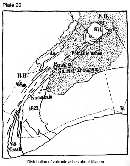
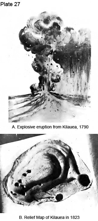
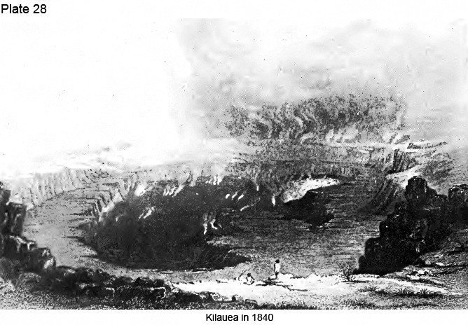
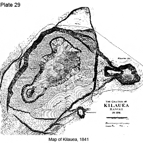
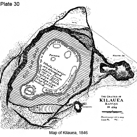
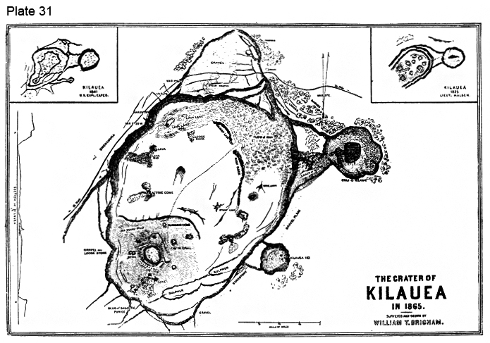
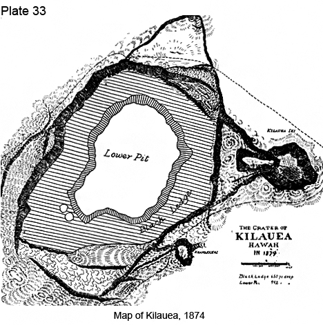
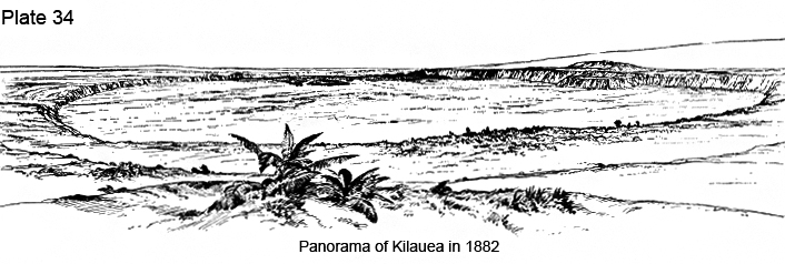
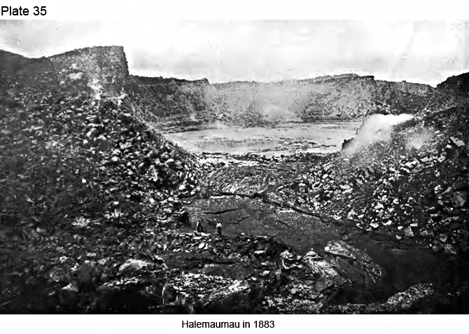
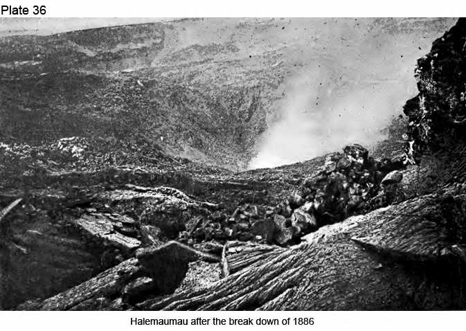
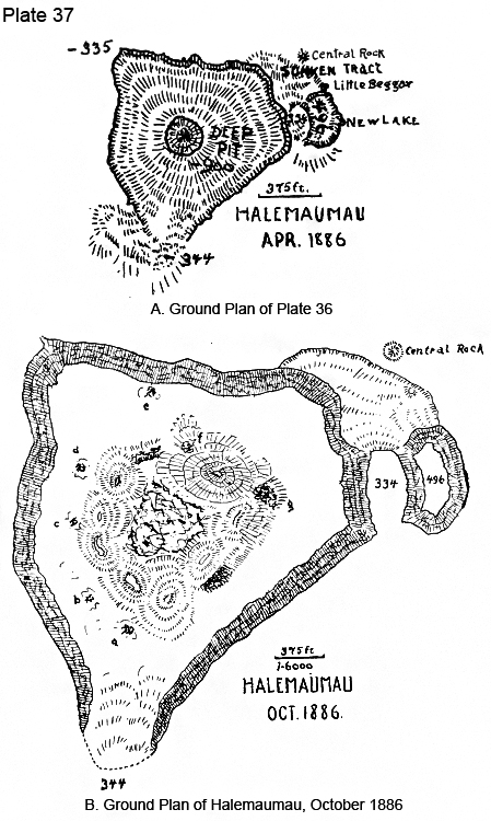
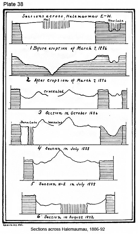
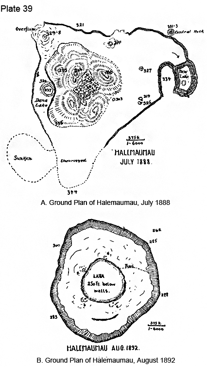
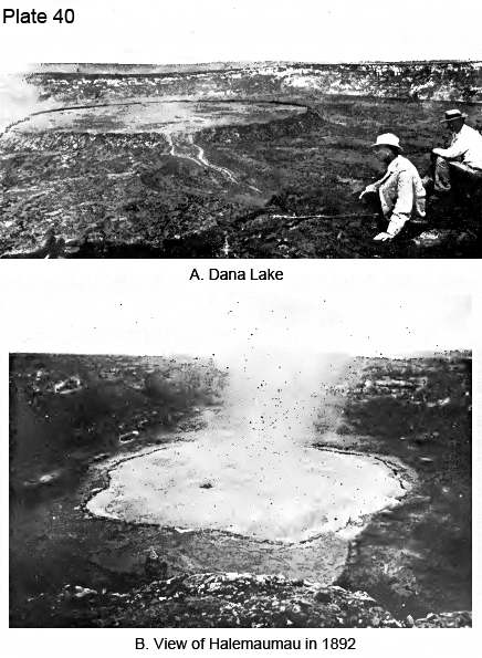
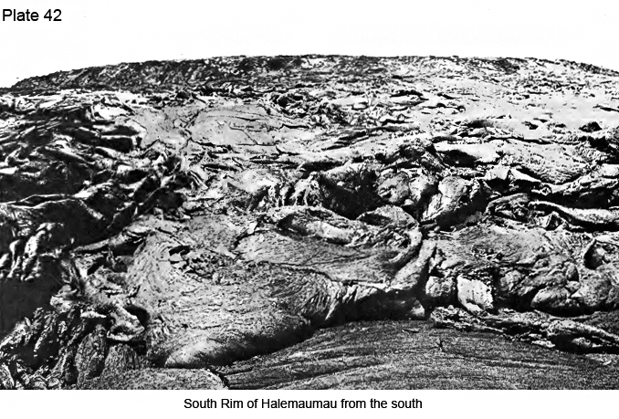
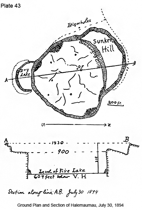
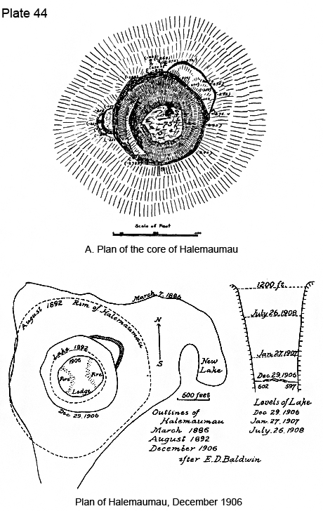
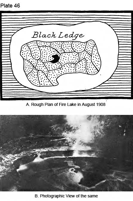

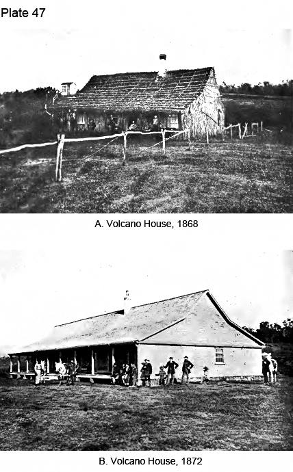
|
|
|
|
|
|
||
| History | Atlas | Culture | Language | Links |