Hawai`i Past and
Present
By WILLIAM R. CASTLE, JR.
New York—Dodd,
Mead and Company 1913
|
CHAPTER 8
Kauai
Kauai, the most northerly island of the group, a steamer trip of one night from Honolulu, has an area of 547 square miles. It is very nearly circular, has a regular shore line, without important harbours, and is made up of the mountain mass of Waialeale, 5,250 feet high. This is not, however, a great dome like any one of the mountains on Hawaii. Kauai is geologically the oldest of the islands, and as a result its mountain has been cut by erosion into hundreds of separate peaks and valleys. The soil washed down has formed lowlands near the shore, except on the northwest side, where there are great sea cliffs of naked rock rising to a height of 2,000 feet. The west central part of the Island is an enormous bog, so nearly impassable that it makes the ascent of the central peak extremely difficult. It forms, however, an inexhaustible watershed for the southern and southwestern slopes. Over this bog there is usually dense fog—practically the only fog in the Islands—a characteristic which makes exploration of the interior even more difficult. Indeed very little was known of it until recently, when the plantations penetrated inland in search of a permanent water supply. The northern part of the Island is very rainy, Hanalei having a rainfall equal to that of Hilo. The Island used to be densely wooded, but there are at present no forests except on the higher mountain slopes, as cattle first destroyed them on the lowlands and the ground has since been appropriated for the cultivation of sugar, rice, and pineapples. Abundant rainfall or water supply, combined with the extreme fertility of the soil, keeps everything green, and has rightly given to Kauai the name of the Garden Island. As the roads are excellent and the distances short, the principal points of interest can be covered in a five-day round trip from Honolulu, a trip tremendously worth taking by those who are not afraid of a rough night at sea. There are comfortable hotels at Hanalei, Lihue, and Waimea.
Landing at Waimea, on the southwestern side of the Island, where Captain Cook first stepped on Hawaiian territory, arrangements can readily be made for seeing the Island. Short excursions may be taken from Waimea itself as follows: Fifteen miles to the northwest, over a good road, at the extreme western point of the Island, are a line of windblown sand hills called the Barking Sands. The wind on the sands makes them rustle like silk; to slide down them produces a sound like thunder; to stamp on them makes them cry out in different cadences. This sand is a natural curiosity existing in very few places, and is amusing to grown people as well as to children. Near the sands, at Polihale, is a famous old Hawaiian bathing beach —one of the "lucky places"—which, besides being an ideal place for a swim, is still supposed by the natives to bring special good fortune to all who enter the water. The great upland plains beyond, one of the dryest and most beautiful spots in the Islands, may soon be set aside as a permanent Government reserve. Another trip, which takes the better part of a day, is back through the Waimea Gulch as far as Puukapele, 3,600 feet high, where is obtained the best view of the surrounding country. This valley, originally a fissure in the mountain, cuts across all the ridges that run southwest from the central mass and leads far into the interior of the Island. The trip, which must be made on horseback, leads through magnificent scenery, between the mighty walls of the valley, which, on account of the vivid colourings of the rocks, has been called the Grand Cañon of the Colorado in miniature. The canon part of the valley is 3,000 feet deep and about a mile wide, the sides precipitous, ending in sharp peaks and cut by grim gorges. In the decomposing rocks the colours are as vivid as though volcanic fires were still at work. Another excursion of six miles, which can be made by carriage, is to the Okolele Ditch, the great engineering work that revealed the Okolele Cañon, the existence of which was barely known a few years ago. The last part of the ditch is a six-mile tunnel carried through the precipices on the sides of the valley. The road which leads to the valley only allows one to look down into the canon, with its bluffs of painted rock rising from the narrow, twisting gorge at the bottom. This, too, is suggestive of the Grand Cañon, except for the trees which somehow cling to its almost perpendicular sides wherever a crevice gives a chance for their roots to take hold. At Waimea itself, a picturesquely situated village, which used to be the capital of the Island and had a large native population, there is little of particular interest except the ruins of the Russian fort on the headland overlooking the harbour. This was built in 1815 by Russian traders, ostensibly for the King of Kauai, but over it flew the Russian flag, and it was undoubtedly intended as the first step toward annexation of the Island by Russia.
An excellent road leads from Waimea southeastward and eastward to Lihue. It passes first through Makawele, the largest plantation in the Island, and the second of those forming a belt around it. This plantation occupies land which was originally a dry plain, but water was brought from the Hanapepe Valley and by ditch from the Okolele Cañon, and there is now abundance at all seasons of the year. A carriage road leads five miles into the Hanapepe Valley, and an easy trail of five miles more brings one to the Falls, which are very beautiful, as they have a large volume of water and are 250 feet high. Beyond Hanapepe the main road turns inland, but at Lawai a branch road leads southeast to serve the pretty little village of Koloa, passing first through the eight miles of property of the McBride Sugar Company. This was among the first plantations seriously to introduce small homesteading among its employees. Part of the uplands back of the plantation was divided into five-acre lots, which were assigned to European immigrants on terms of very easy payment. These homesteads, on which pineapples are the principal crop, are cultivated largely by the women and children, while father and older boys work in the plantation fields. Indeed, on most of the Kauai plantations this plan of homesteading, or some form of co-operative labour, has been tried with striking success. At the Kilauea Plantation, on the north side of the Island, there are Portuguese labourers who have been connected with the property for over thirty years. The village of Koloa is in itself uninteresting, but two miles from it is the Spouting Horn, a curious rock formation on the shore, where the waves rush into a cave and force intermittent jets of water high into the air through a narrow crevice above the inner end. It is much more active than are most spouting horns, and is a perpetual fountain well worth seeing. The Haupu, or Hoary Head Ridge, 2,000 feet high, runs eastward from the central mountain to the sea, and the end of it, the highest point, forms a bold promontory rising perpendicularly out of the ocean a few miles south of Lihue. This ridge, which was formerly part of the backbone of the mountain, has been intersected by erosion and through this gap runs the main road to the eastern side of the Island.
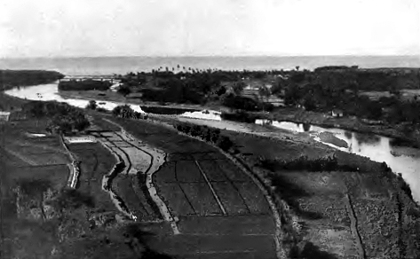
Lihue itself, twenty-six miles from Waimea, is the county seat. The town, which has a large German settlement, is beautifully situated on both banks of the Nawiliwili Gulch. Back of it is a curious tufa cone, the Kilohana crater, which was thrown up long after volcanic activity had ceased, indeed after erosion had done much of its work. Material ejected from this crater covered the region for a radius of several miles, so that streams had to make new channels for themselves, flowing finally into the rivers to the north and to the south. From this cone, which is easily accessible on horseback or on foot, there is a splendid panorama of ocean and mountain, cultivated field and forest, of the whole lovely plain that makes the east side of the Island. A few miles north of Lihue the Wailua Valley is noted for its beautiful waterfalls, and both the upper and lower falls, with their surrounding of verdure-covered crags, well repay the horseback trip of ten miles necessary to visit them. The lower part of the river is navigable for small boats, and canoe trips between its banks, that are overgrown with shrubs and vines to the edge of the water, are always popular with residents of Lihue. Perhaps this is even more so since the drive of six miles to the mouth of the river is one of the finest of the many marine drives in the Islands.
This is the first part of the excellent automobile road that follows the shore for thirty-four miles to Hanalei. It leads northward through rice fields and plantations, past Anahola, where rugged, inaccessible bluffs meet the beating of waves and the strong sweep of trade winds at the northeastern comer of the Island, to Kilauea, and then turns westward, following the northern shore. Hanalei, a thriving village, is one of the most picturesque spots to be found anywhere. Like Waimea and Lihue, it may be reached by steamer direct from Honolulu, and, with its good hotel, is a comfortable centre for excursions. From the steamer one looks up the broad, fertile valley that extends between its steep boundaries for miles back into the mountains. Down its sides fall innumerable silver, thread-like waterfalls, that now disappear behind thick foliage, now leap over sheer precipices, to dissolve in mist before they reach the floor of the valley. Perhaps the loveliest view, however, is that looking down from the east bank as one approaches from Lihue, because here one gets the full expanse of the level valley bottom, with its broad river, the largest in the Islands, winding serenely between fields of vivid green rice, between little clusters of Hawaiian houses, where the natives have lived for generations and still live, peacefully unconscious of the march of civilisation, of the turmoil of the world outside. One overlooks also the horseshoe bay, with the ocean beyond, and to the left sees deep into the verdure-covered valleys, over the ridges to the cloud-capped mountain in the distance. At Hanalei is another famous bathing beach, and for those who prefer there is here also good fresh-water swimming in the river.
A beautiful drive westward leads, after five miles, to the mouth of the glorious Wainiha Valley. Before reaching it, however, one crosses, on a bridge, the stream of the Lumahai Valley. This bridge has done away with the last of the old ferries, which were formerly a characteristic feature of travel on Kauai. It is a region of legend. The Waikoko River—the Water of Blood—recalls by its name a sanguinary battle of ancient times. The Wainiha Valley is one of the finest and deepest of Hawaiian canons. It cuts into the mountain for some fifteen miles, almost intersecting the highest point of the Island and reaching nearly to the head-waters of the Okolele and Hanapepe streams, which flow into the sea on the other side of the Island. Toward the upper part of Wainiha the perpendicular rock walls are four thousand and more feet in height. Nowhere in the Islands, except in west Maui, is there such a titanic fissure in the mountains, nowhere more stupendous precipices. A carriage road extends two miles into the valley and is continued for several miles by a trail which at one point leads up the western ridge to a height of about 4,000 feet. At the end of the carriage road is the station of the Kauai Electric Company, which sends power through its wires, strung on poles, to all parts of the Island. So excellent is the plant that electricity is used commercially in Kauai to a far greater extent than elsewhere in the group, many of the pumping stations on the southern shores being run by power from Wainiha. A splendid tramp of a day or two may be taken through the wildest of tropical forests along this pole-line, the best access to the trail being, however, from Lihue on the southeast. Walkers should bear in mind that on Kauai it is wise always to keep to well-defined trails or to take a guide, since the formation of the Island is such that it is very easy to get lost. Just beyond the Wainiha Valley, and reached by a good carriage road, is Haena Point, with its interesting caves. They are at sea level and extend for a long distance through old lava channels under the cliffs. One is filled with fresh water. The rock formations of the sides and the roofs are fantastic, with their queer stalactites and their rope-like columns of twisted lava that might almost have served as models for the columns in the cloister of St. Paul's outside the walls of Rome. The light refracted through the water is wonderfully softened and coloured, just as it is in the grottoes at Capri. In one of the caves a canoe has been placed for the use of visitors. The carriage road extends only a mile or two beyond the Point, reaching then the wild, precipitous, and little explored section of the Island known as Napali.
Here the cliffs, in places over 2,000 feet high, fall sheer into the sea, leaving not a vestige even of beach, nor a pathway along the water. These cliffs are cut by innumerable ragged gorges, which extend, however, only a short distance Inland, ending abruptly at the ridge back of the Wainiha Valley and a little further south at that back of the Waimea Valley. At the heads of these gorges are often broad basins, like little craters, and along their precipitous sides are spires of rock like the needles of the Alps, both the effect of erosion. Toward the southern part of this region the gorges become the narrowest of canons, entering the sea through mere slits in the rocky wall. The Kalalau Valley, the most important in Napali, and in the centre of the section, used to have a large, if isolated, population, but to-day only a few poor huts are left. A favourite tramp from Hanalei is along the shore penetrating Napali as far as Hanakapiai. Beyond this point the trail is very difficult, but runs on, up and down across the gorges as far as the Kalalau Valley. From here the only possible way to continue around the Island is by canoe for seven or eight miles to the end of the cliffs. The canoe trip of twenty miles along the whole of the district is a thrilling experience, but can, of course, be taken only in the calmest weather. Occasionally one of the inter-island steamers makes the circuit of Kauai, and no trip in the Islands can show finer scenery. The bluffs and canons are all bare of vegetation near the sea—walls and towers of ancient rock, awe-inspiring in their majesty and in their solitude. They are of lava, weathered by the ages into grey and purple and yellow and orange. In the pockets are patches of bright red soil, and here and there huge rocks protrude that are black and glistening, like coal. From the ocean one sees back of all this desolation the green of the forests and the yellow of upland grasses half hidden in the mountain mists. Napali is an ideal region for the sportsman. (A shooting permit is necessary and should be obtained in Lihue.) Wild goats climb over all the ridges. The shores swarm with fish. Camping trips are always practicable; the natives are always friendly, willing for small pay to act as guides, packers, and cooks. The district is perhaps the wildest in the Island, as little known as any, magnificent in its scenery, which is so different from any other, so insistently suggestive of solitude and of remoteness from the world, that the Hawaiians have invested almost every part of it with some strange legend of the ancient gods and demigods.
The excellent road, already ninety miles long, which is planned ultimately to circle the Island, is still broken by the thirty miles and more of the cliffs and gorges of Napali. The trip around the entire Island can be made only, therefore, if the sea is calm enough to permit of a long canoe trip, but as elsewhere the roads are excellent, Kauai is an ideal place for driving and motoring. Regular! excursions are arranged in connection with the sailings of the inter-island steamers, and these give a good impression of the country. The climate is so pleasant, however, the scenery so fine, and the people so hospitable, that Kauai is the best of the Islands for camping trips and it is only by getting back into the mountains that one comes to understand the charm of the old Hawaiian life, to realise the enthusiasm of Kauai people for their own land, and to appreciate the name they have given it of the Garden Island.
The little island of Niihau, a part of the county of Kauai, lying seventeen miles west of the larger island, and containing 97 square miles, is a private estate, used largely for ranching purposes. Only a few people live on it now, but it must have been an important centre of population in 1778, as Captain Cook's ships remained there for several days taking on water and provisions. Niihau is principally known to the outsider to-day for the chains made from tiny white shells which are found on the beaches, and for the Niihau mats. The Hawaiians braid large quantities of mats, but none are so soft and fine as those made from the rushes which grow in the marshes of this insignificant island. |
||
|
|
|
|
|
|
||
| History | Atlas | Culture | Language | Links |