Natural History of
Hawai`i
SECTION TWO – GEOLOGY, GEOGRAPHY
AND TOPOGRAPHY OF THE HAWAIIAN ISLANDS
|
CHAPTER 8: Coming of Pele and an Account of the Low Islands of the Group
Pele's Journey to Hawaii
There is perhaps no better way to begin an account of the natural history of the Hawaiian Islands than by recounting an Hawaiian legend that tells of the coming of Pele, that powerful mythical deity of fire and flood, feared and respected by all the ancient inhabitants of the group as the source, as well as the end, of all the wonderful volcanic phenomena with which they were familiar.
In the beginning, so one version of the legend runs, long, long ago, before things were as they now are, there was born a most wonderful child called Pele. Hapakuela was the land of her birth, a far distant land out on the edge of the sky—away, ever so far away to the southwest. There she lived with her parents and her brothers and sisters, as a happy child until she had grown to womanhood, when she fell in love and was married. But ere long her husband grew neglectful of her and her charms, and at length was enticed away from her and from their island home. After a dreary period of longing and waiting for her lover, Pele determined to set out on the perilous and uncertain journey in quest of him.
When the time came for the journey her parents, who must have been very remarkable people indeed, made her a gift of the sea to bear her canoes upon. We are told that among other wonderful gifts Pele had power to pour forth the sea from her forehead as she went. So, when all was in readiness, she and her brothers set forth together, singing, making songs, and sailing—on, on, on over the new-made sea—out over the great unknown in the direction of what we now know as the Hawaiian Islands.
PLATE 19: VIEWS ON MIDWAY AND OCEAN ISLANDS
1. Midway Island; looking from sand islet towards green islet, showing the characteristic vegetation. 2. Showing the cable station on Midway Island. Note the growth of sand grass (Cynodon dactylon) in the foreground. 3. View on Ocean Island showing the formation of sand hills under the protection of the low bushes. 4. Hut built on green islet by Japanese bird poachers. 5. Midway Island home of Capt. Walker and family, who were shipwrecked on the island in 1887 and spent fourteen months there before being rescued. (The hut has since been burned).
But in the time of which the legend tells the islands of Hawaii were not islands at all, but were a group of vast unwatered Mountains standing on a great plain that has since become the ocean floor. There was not even fresh water on these mountains until Pele brought it. But as she journeyed in search of her husband, the waters of the sea preceded her, covering over the bed of the ocean. It rose before her until only the tops of the highest mountains were visible; all else was covered by the mighty deluge. As time went on, the water receded to the present level, and thus it was that the sea was brought to Hawaii-nei.
From her coming until now, Pele has continued to dwell in the Hawaiian Islands. According to the legend, her home was first on Kauai—one of the northern islands of the group. From there she moved to Molokai and settled in the crater Kauhako. Later she removed to Maui and established herself in the crater hill of Puulaina, near Lahaina. After a time she moved again to Haleakala, where she hollowed out that mighty crater. Finally, as a last resort, she settled in the great crater of Kilauea, on Hawaii, where she has even since made her abode.
In this way Pele came to be the presiding goddess of Kilauea and to rule over its fiery flood, and from those ancient days to the present, she has been respected as the ranking goddess of all volcanoes, with power at her command to lift islands from the sea, to rend towering mountain peaks, to make the very earth tremble at her command, to obscure the sun with stifling smoke, to cause rivers of molten rock to flow down the mountains like water, and above all to keep the fires forever burning in her subterranean abode.
This interesting legend should be regarded as a sincere effort of the Hawaiian mind to account for the presence in the islands of the primeval power they saw in the volcano and to explain certain fundamental phenomena of nature which surrounded them on every hand. Here were the islands, here were the burning mountains, here was the great sea, here were the people, the animals and the plants. Whence came they all, and how did they come to be?
Legend and Science Agree
With all our boasted science, we are still groping, as were the ancient Hawaiians, seeking an explanation of the beginning of the islands, and of the marvelous variety of life which they support. In the search, science has substituted theory for legend, and observation for myth, but when we compare the legendary course of Pele as she moved her home, from the oldest island, Kauai, to the young island, Hawaii, with the theory that geologists have worked out to account for certain basic facts in the evolution of the group, we are surprised to find that legend so closely accords with the modern accepted theory of tile succession in time of the extinction of the volcanic fires that marked the completion of one island after another, until Hawaii alone can boast of the possession of the eternal fires.
PLATE 20: VIEWS OF LAYSAN ISLAND
1. Shows the sea breaking along the rocky ledge at the southeast point. 2. The lighthouse and manager’s quarters showing two cocoanut trees brought from Strong’s Island. 3. Laysan Albatross. 4. Loading guano in a large schooner. 5. A lighter load of guano. 6. General view of the settlement on the “harbor” (west) side of the island.
Geographic Position of the Islands
Considering the Hawaiian Islands in relation to each other and to the rest of the world, we find this wonderful group of mid-Pacific islands to he made up of twenty-one islands and a number of other small islets that are contiguous to the shores of the larger ones. For the sake of convenience, the group, which stretches for about 2,000 miles from southeast to northwest, has been divided into the leeward or northwest, and the windward or inhabited chain. In the leeward islands are grouped eight low coral islands and reefs, and five of the lowest of the high islands. Beginning at the western extremity, the low group includes Ocean Island, ten feet high; Midway Island, fifty-seven feet high; Gambier Shoal, Pearl and Hermes Reef, Lisiansky Island, fifty feet high; Laysan Island, forty feet high, and Maro and Dowsett Reefs.
These are probably the tops of submerged mountains that have had their summits brought up to or above the surface of the ocean by the combined action of the hardy reef-building corals, the waves, and the transporting power of the wind. The wind has had an important part in their final form, since it has gathered up the dry soil left above the ordinary action of the wave and piled it, as at Midway, in the center of a secure enclosure, formed by an encircling coral reef, or as at Laysan, to form a sand rim about an elevated coral lagoon.
Lying between the group of low islands and forming a connecting link with the high or inhabited group, are five islands, the lowest of the high islands. They form a transition group between the coral and the volcanic islands and a second division of the leeward chain, and are made up of Gardner Island. 170 feet high; French Frigates Shoal, 120 feet high; Necker Island, 800 feet high; Frost Shoal, and Nihoa or Bird Island, 903 feet high.
Together with the low islands, they form the leeward chain of thirteen islets, reefs and shoals that have a combined area of something over six square miles, or about four thousand acres. With the exception of Midway, which is the relay station for the Commercial Pacific Cable Company's wire across the Pacific, they are uninhabited at the present time. The entire chain, with the exception of Midway, has been set aside by the federal government to form the Hawaiian Islands Bird Reservation, which, taken collectively, forms the largest and most populous bird colony in the world.
To many these remote, shimmering, uninhabited islands are devoid of interest; to the naturalist, however, every square foot of the surface, and all the life that inhabits them, has an interesting story to tell. The geologist finds in them subjects of the greatest interest and importance. The thrilling story of their up-building through centuries by the tireless activity of the tiny animal, the coral polyp, that by nature is endowed with the mysterious power of extracting certain elements in solution from the sea water and little by little transforming them into a reef of solid lime-stone masonry, which, in time, becomes the foundation of inhabited land is indeed most wonderful.
As the formation and growth of coral islands and reefs has been a subject profound enough to engage the attention of such thinkers as Darwin, Agassiz, Dana, Wallace, and a score of others, it is small wonder that these coral islands, which gem the surface of our summer seas, are invested with vital interest for those who feel a scientific concern in them and who are permitted to study them.
Ocean Island
The leeward chain furnishes interesting examples of the various types of coral islands. Ocean Island, the extreme western end of the Hawaiian chain, lies in 178° 29' 45" west longitude, and 28° 25' 45" north latitude, and is almost at the antipodes from Greenwich, and, as it lies in the northern limit of the coral belt, it furnishes an excellent example of a circular barrier atoll in mid-ocean. The coral rim surrounds and forms a barrier about four small sand islets and is approximately sixteen miles in circumference. The rim is broken for a mile or more on the western side, but the lagoon enclosed is too shallow to admit the entrance of sea-going ships. Over this low coral rim the curving line of white breakers beat, forming a snowy girdle about the low islets that lie protected within.
Midway Island
Midway Island is fifty-six miles to the east of Ocean Island, and, like it, is made up of a low circular coral rim or atoll, six miles in diameter, averaging five feet in height by twenty feet in width, which is open to the west. Like Ocean, it has one fair-sized sand islet and one that is covered with shrubbery. These islets lie in the southern part of the circle, about a mile apart, and are utilized as stations by the cable company. The coral rim encloses an area of about forty square miles of quiet water which attains a depth of eight fathoms. The island was discovered in 1859 by Captain Brooks, who took possession of it for the United States. Attempts to utilize it as a coaling station were abandoned after a single trial; but in 1902 it was successfully occupied by the cable company, and has since been regularly visited by vessels carrying provisions and supplies.
Just prior to my visit in 1902, which preceded the arrival of the cable by a few months, the island had been visited and devastated by a party of poachers engaged in securing birds' feathers for millinery purposes. The dead bodies of thousands of birds, ruthlessly slaughtered by them for their wings and tails, were thickly strewn over both islets. The reports made at the time, by the writer, to the State Department and various officials in Washington, was the first step in the long campaign that finally resulted in the establishment of the Hawaiian Islands Bird Reservation.
Gambier Shoal
Gambier Shoal is a circular atoll lying about half way between Midway and Pearl and Hermes Reef. The latter is an irregular oval atoll, about forty miles in circumference, which encloses a dozen small islets of shifting sand. It was discovered in 1822 by two whaling vessels, both of which were wrecked on the reef the same night within ten miles of each other, thus giving the reef its double name, and establishing a record for the locality that has served as a danger warning to mariners even to the present day.
Lisiansky, discovered in 1805 by a Russian, for whom it is named, is a small oval island composed mostly of coral sand. It is about two miles by three miles in extent and is surrounded by shallow water, but is without a central lagoon. Like Midway and Laysan, it has been visited by bird poachers from time to time. In 1905 a party of Japanese were found on the island engaged in killing birds for the millinery trade. It was estimated by the officers of the U. S. Revenue Cutter Thetis, who arrested the offenders, that they had killed three hundred thousand birds during the season.
Laysan
Laysan Island was an American discovery, made in 1828, and named by the captain for his vessel. It was taken possession of by the Hawaiian Kingdom and later proved to be a rich guano island. For years it was leased to a firm in Honolulu, which removed thousands of tons of valuable fertilizer from it. Laysan is about two miles long by a mile and a half in breadth. The writer has estimated that during the year 1902 it was inhabited by ten million sea birds that roam over the central north Pacific Ocean. This island differs from those previously considered in that it is unmistakably an elevated coral atoll, since it holds in its center a large briney lake, that has its surface slightly above the level of the sea that surrounds the island. The evidence seems to indicate that what was a low atoll at some remote period, possibly during the late Pliocene, was elevated and transformed, so that the atoll became a lake in mid-ocean surrounded by a ring of coral sand. The island is in turn practically surrounded by a coral reef with here and there an opening of sufficient size to admit a small row boat.
The harbor is on the southwest side and affords a safe anchorage in the lee of the island. The island has been more or less continuously inhabited for a number of years, and has been visited on several occasions by naturalists, so that its fauna and flora have been more fully studied and the island made more widely known than any of the other islands in the leeward chain. In another connection the remarkable bird population for which Laysan is justly famous has been referred to at some length.
The guano deposits have been very extensively worked and may now be regarded as practically exhausted. The beds were located on the inner slopes of the sand rim of the island at each end of the lake or lagoon. Originally they were from a few inches to two feet in thickness and varied greatly in the percentage of phosphate of lime—the valuable property for which they were worked. The bones and eggs of the birds whose excrement, in combination with the coral sand, formed the rich calcium phosphate or guano fertilizer, were often found in these beds in a semi-fossilized state, pointing to the way in which similar fossils have been embedded elsewhere in much older deposits.
The rate of deposition of this valuable fertilizer is necessarily very slow and is in direct proportion to the bird population. While it continues to be deposited, the amount is small as the colony has been seriously interfered with owing to the slaughter of the greater number of the large albatross, which doubtless have always been the chief factors in guano production in these waters.
Maro Reef was also the discovery of an American whaling ship in 1820. It is a rough quadrangular wreath of white breakers, about thirty-five miles in circumference, with no land in sight.
Dowsett Reef is but thirteen miles south of Maro, and like it. is evidently a young reef as compared with Laysan, since only a few rocks are awash here and there above the breakers. It was named for Captain Dowsett of the whaling brig "Kamehameha." whose vessel struck on the reef in 1872.
PLATE 21: REEFS AND ISLANDS IN THE LEEWARD CHAIN
1. Bird Island, Nihoa, (volcanic) from the northwest. 2. Seal on beach at Pearl and Hermes Reef. 3. Necker Island (low volcanic island) south side. 4. Skinning a seal on Pearl and Hermes Reef. 5. French Frigates Shoal (volcanic formation).
Gardner and French Frigates Shoal
Coming next to the second division of the leeward chain, we find, with the possible exception of Frost Shoal, which is thirteen miles southwest of Nihoa, that they are no longer wholly of coral formation. Gardner, the first of these islands, is a cone-shaped rock 170 feet high by 600 feet or more in diameter. There is a small island lying a short distance to the east of the main rock, but deep water comes up close to the main island on all sides, and vertical sea cliffs, sixty or seventy feet high, surround it on all sides. It was discovered by an American whaler in 1820, but has seldom been visited since. This is the first exposed evidence of volcanic rock to be met within the chain, and is of special interest, since it is more than 700 miles east and south of Ocean Island, and is at least 600 miles northwest of Honolulu. Such facts give the reader an idea of the magnificent distances one encounters in traveling through the length of the Hawaiian group. It also emphasizes the extent and magnitude of the chain of volcanic mountains submerged in the central north Pacific, of which, according to the legend of Pele's coming, previously related, and the opinion of learned geologists, only the tops of the tallest peaks are exposed.
The French Frigates Shoal is about thirty square miles in extent and was discovered by the great navigator La Perouse in 1796, and by him named for the two French frigates under his command. A striking volcanic rock, 120 feet high, rises from the lagoon, which is filled with growing reefs and shifting sand-banks. The surrounding reefs form a barrier about the volcanic point within and is perhaps the best example of this form of reef in the group.
Necker Island
Necker Island was discovered in 1786 during the same expedition that made the French Frigates Shoal first known to the world. It was named by the discoverer for the great French statesman and financier who convened the French States-General in 1781. The island, as shown by the steep sea cliffs, is the remains of a soil-capped volcanic crater, that is about 300 feet high, three-fourths of a mile in length, by 500 feet in width, at the widest part. It is surrounded by shallow water; there being an extensive shoal, principally on the south side.
This island and near-by Nihoa, or Bird Island, are of special interest as they were visited in ancient times by hunting and fishing parties from Kauai, who made the journey to it in their outrigger canoes. As Necker is 250 miles distant from the nearest inhabited island, the journey thither would seem to be one not to be lightly undertaken. But as the island was one of the few sources of supply of the coveted frigate and tropic bird feathers much used in their feather work, the journey seems to have been made more or less regularly.
The level portion on top of the island of Necker is more or less covered with a number of curiously formed stone enclosures, which may have been temples, in which have been found several remarkable stone images, fifteen inches or more in height. These, together with a number of curiously formed stone dishes with which they were associated, are now in the Bishop Museum. They are of such unusual design and workmanship as to make them appear relics of some race other than the Hawaiian. However, as the Hawaiian is the only race known to have visited these remote islands at so early a period, and as they were by nature a very religious people, there still remains the possibility that the relics, including the stone enclosures, if not of their making, were at least known to and probably made use of by them.
Nihoa
Nihoa completes the list of the leeward uninhabited islands of the Hawaiian group. It is 150 miles east of Necker and 120 miles northwest from Niihau, the nearest inhabited island. It is the highest island in the leeward chain, its summit being a pinnacle at the northwest end which rises 900 feet above the sea. The island is about a mile in length by 2,000 feet in breadth, which gives it an area of 250 acres. It is unmistakably the eroded remains of a very ancient and deeply submerged crater, the outer slopes of which have been worn away, leaving only a portion of the familiar, hollowed, volcanic bowl. The materials of which it is composed are similar to those of the high islands, and there is every evidence that it is even more ancient than Kauai.
Dr. Sereno Bishop, who visited it in 1885 as the geologist of a party, headed by the then Princess Liliuokalani, declared the island to be a pair of clinker pinnacles out of the inner cone of a once mighty volcanic dome, which has been eaten down by wind and rain for thousands of feet during unreckoned ages. From the large number of basaltic dikes which cut the island from end to end. he was led to infer that Nihoa is the result of an extremely protracted period of igneous activity. Perhaps this hoary remnant of the past may at one time have been a stately island, like those of the inhabited group with which we are familiar, that through submergence and erosion, has been reduced almost to sea level. Back to Contents
CHAPTER 9: The Inhabited Islands: A Description of Kauai and Niihau
Hawaii-nei: Position of the Inhabited Islands. The wonderful group of high, inhabited, volcanic islands over the formation, or at least the completion, of which the Hawaiians believed Pele presided, consists of the islands of Hawaii, Kahoolawe, Maui, Lanai, Molokai, Oahu, Kauai and Niihau, together with several smaller islands scattered about them. Taken collectively they form the Hawaiian group as it is generally understood, or as the natives expressed it, "Hawaii-nei," meaning all Hawaii. They are anchored far out in the middle of the north Pacific, under the Tropic of Cancer, and extend in a northwesterly direction from Hawaii, the southern most, to Niihau, a distance of about 400 miles. Honolulu, the capital and principal port of the Territory of Hawaii, is located on Oahu. The position of the Territorial observatory in the capitol grounds in Honolulu is in W. long. 157° 18' 0" and N. lat. 21° 18' 02", and is at a point about fifty miles north and west of the geographical center of the inhabited group.
Like most volcanic islands, the Hawaiian Islands lie in a more or less straight line; or to be more exact, in two nearly parallel lines, and are supposed by some to be superimposed over a great crack in the ocean's floor, and by others to rise from a submerged plateau.
Looking more broadly at the group in its relation to the rest of the world, we find the islands situated at the cross-roads of the Pacific Ocean, 2,100 miles southwest from San Francisco and eleven days' journey by the fastest train and ship, from New York. They are planted far out in the deep blue waters of the Pacific and are the most isolated islands in the world. It is twelve to eighteen thousand feet down to the ocean's floor on all sides of the group, and, as has already been said, it is believed that all of the islands are the exposed summits of gigantic mountains that rise more or less abruptly from the very bed of the Pacific Ocean.
This chain of fantastically sculptured volcanic mountain peaks, is made up of fifteen great craters, of the first magnitude, all of which at one time or another have been active. All but three of them. however, have been dead and extinct for centuries, perhaps thousands of centuries. Fortunately all three of the active volcanoes are located on Hawaii, the southernmost. and undoubtedly the youngest island of the group.
Since Honolulu is ordinarily the point of arrival and departure for trans-Pacific steamers, as well as inter-island boats, it is well to make it the center from which to study, in some detail; the main geographic, topographic and geologic features of the group.
PLATE 22: MAP OF THE HIGH OR INHABITED ISLANDS OF THE HAWAIIAN GROUP
Niihau
To the northwest of Honolulu lie the islands of Niihau and Kauai. The former, the farther removed of the two, is in a northwesterly direction from Honolulu and is in line with the islands mentioned in another chapter as forming the leeward chain. It is seventeen miles west of Kauai from which it is separated by a very deep ocean channel. It is about eighteen miles long by eight miles in width, at the widest part, and has an area of ninety-seven square miles. The highest portion attains an elevation of about l,300 feet above sea level.
The island consists of a high central section called Kaeo, surrounded by a plain on three sides. On the north and west sides it is the highest and it is here that steep cliffs occur where the high land joins the summit flat. The higher part is irregular and of a basaltic origin, but is without the sharp peaks that characterize some of the larger islands. A large, natural pond near the center of the island and several smaller ponds and artificial reservoirs are found in various sections.
While Niihau shows evidence of great erosion it is evident that its moderate height and small size has prevented it receiving the abundant rainfall which has been an important factor in aging its larger companions.
A large part of the island is low, apparently of coral or aeolian origin, and is the inhabited section. The island is now utilized as a great sheep ranch, there being extensive areas of grass land, especially suited to grazing. Perhaps 150 natives, mostly comparatively new arrivals, now inhabit the island, and together with the old inhabitants, all told, are but a remnant of the thousand sturdy Hawaiians who made it their home less than seventy years ago. The island is noted in the group as the one on which is found the famous sedge from which the natives weave their serviceable soft grass mats, although the same plant occurs in suitable localities on all of the islands. The beaches are strewn with beautiful, though small, sea shells, known as Niihau shells, which are strung into long necklaces called Niihau leis.
Near Niihau are two cinder cones, Kaula on the west and Lehua on the northeast, which form small detached islands. Prof. Hitchcock says, '"The first is about the size and shape of Punchbowl, cut in two and the lower half destroyed by the waves. The concentric structure of the yellow cinders, much like the lower surface of Koko Head, is very obvious. Lehua appears to be a similar remnant, less eroded, as it has maintained about 200 degrees of its circumference instead of the 140 degrees of Kaula. Both these crater cones have the western or leeward side the hiuhest, because the trade winds drive the falling rain of ashes and lapilli in the direction of the air movement, building up a compact laminated pile of material to leeward. The subsequent erosion by the waves fashion a crescent-shaped island opening to the winds and surges upon the northeast side."
Kauai—The Garden Island
Kauai, next to the smallest of the five large islands, seems to agree with Niihau in age of formation. In fact, it is suggested that some great force has torn the smaller island away from the larger one without disturbing the strata of either. It is nearly circular and at the same time roughly quadrangular in form. Excepting the Mana flats, which seem to be uplifted coral reefs, the island could all be included within a circle, with a radius of fifteen miles, using Waialeale, the highest point, as the pivot. It is a beautiful, rich, well-watered island clothed with varied and luxuriant verdure and as such is often spoken of as the "Garden Island" of the group. Disintegration of the lava has proceeded farther here than on the other islands, a fact, taken in connection with other data, as indicating that the volcanic fires died out first at this end of the chain.
PLATE 23: VIEWS ON KAUAI
1. Wild mountain scenery along Olokele Cañon. 2. View from the mouth of the Wailua Stream. 3. The village of Hana-maulu. 4. Wailua Falls. 5. View along the east of Hanalei.
The coast is singularly regular in outline, there being no extensive bays or pronounced points or headlands. Except along the northwest side of the island, at Napali, where there are fifteen miles or more of picturesque sea cliffs, the coast lands are comparatively low and flat. The shore-line is free from coral reefs, presumably owing to the depth of water near the shore. In general the main contour of the island slopes rather gradually from the summit of Waialeale, at an elevation of 5250 feet, down to the sea, though ridges and corresponding valleys radiate spoke-like in all directions.
The eastern and northern side of the island, as is the case with all the islands, has been drenched by tropical rains for countless centuries with the result that erosion by wind and rain is most marked on that side of the island. The original slopes on the windward side of Kauai have been almost entirely eroded, leaving only a few short spur-like ridges. On the opposite or leeward side; however, the erosion is not so marked nor so far advanced, as the deep gorges with wide level spaces between them indicate. These gorges are deep and canon-like, inland, but, as they near the sea-coast, their sides become less precipitous and finally loose their character as the valley reaches the coastal plain.
Waialeale Mountain
Geologists agree that the central dome of Waialeale must have been much higher than now, and that the disintegrated lava has been washed from its summit to form the rich soil that makes up the coastal plain. The effects of erosion have been considered as perhaps the best evidence of the age of the Hawaiian mountains, and this great mountain worn to the core with its one-time lofty central crater eaten down to form a slimy bog on its summit, points to the great antiquity of the island under consideration. The gnawing action of wind and rain leaves only the more resistant ridges, as the old mountain is thus slowly eaten away. This has progressed on Kauai until only the skilled geologists can, in fancy, reconstruct its original dome-like outlines.
Everywhere in the group, but especially on Kauai, is found excellent examples of one-time solid rocks which are passing into fertile soil through the ordinary agencies of disintegration. In its earlier stages the new-formed soil is open and porous like a gravel bed. In this condition it absorbs large quantities of moisture which rapidly seep away from the surface. The power of lava soils to retain moisture varies with the mechanical state of the soil and the amount of organic matter it contains. While the soil under cultivation on Kauai is very fine, and for that reason retains water reasonably well, it is, in most cases, very red in color, indicating that it has not been discolored by the impregnation of vegetable acids, which in the forests and beds of valleys is very liable to produce a characteristic black soil.
PLATE 24: MAP OF THE ISLAND OF KAUAI
Lava Soil
Generally speaking the soil on Kauai is everywhere good, but is light and open, and requires much irrigation to make it fertile. The constant cultivation of the land does much to improve the soil, and by the addition of carefully compounded fertilizer and an abundant supply of water, enormous yields of sugarcane are secured. The growth of various crops affect the soil differently, as they remove from it varying amounts of nitrogen, phosphoric acid, potash and lime, which are the principal elements required by plants as food. Careful experiments have shown that the amount of these elements removed varies greatly even with the different varieties of cane that are grown in the islands. As a result, the care and proper fertilization of the soils of the group has been the subject of much scientific study.
While the main central dome on Kauai is the most conspicuous natural feature, there are other important elevations. The Hoary Head range, which extends down to the coast at Nawiliwili Bay, may be considered as part of the backbone of the main mountains. The highest point on this ridge, Haupu, is 2,080 feet; but between this point and the central dome the ridge is much lower, forming a pass for the Government road from Lawai to Lihue.
Secondary Volcanic Cones
A number of secondary volcanic cones on Kauai are important in the general topography of the island. The largest of these is Kilohana crater, which rises from the level Lihue plain to a height of 1,100 feet. The ejecta from this cone has been thrown over the country-side roundabout within a radius of four or five miles. In the neighborhood of Koloa are several small secondary volcanic cones within the radius of a few miles. The lava emitted by them was black and of a peculiar ropey type. Along the sea-shore the sea water forces its way under the surface and is often expelled through holes and openings in the lava in this vicinity. At favorable seasons the water spouts high in the air, forming great fountains termed "spouting horns.''
A great central forested bog, or morass, extends for miles along the top of the precipice which bounds the Wainiha Valley on the northeast. It slopes gradually to the southwest, and provides the nalural storage reservoir for the headwaters of the Waimea, Makaweli and Hanapepe rivers. This bog forms one of the least known, most dangerous and thoroughly inaccessible regions in the entire Hawaiian group. The writer, with an experienced native guide, spent three weeks in the region in the spring of 1900, and amid chilling rains and bewildering fogs, made an expedition extending through four days over miles of quaking moss-grown bog to a point designated by the guide as thesummit of Waialeale. We were never out of the dense fog during the expedition, and that we returned to our camp and to civilization at all has always seemed little short of the miraculous.
In many sections the thin turf, which covered the quagmire beneath, would tremble for yards in all directions at every step, and too often at a false step from the proper route, would give way, plunging us hip deep in the mire. Our chief concern was to locate reasonably solid ground, a necessary precaution that entailed many weary miles of wandering in the weird moss-grown wilderness, with attendant hardships and hazardous experiences that are still vivid in memory.
Cañons of Kauai
The numerous valleys and cañons of Kauai, and their attendant streams have justly been celebrated for their beauty and grandeur. Waimea is one of the finest, since it has cut its way between perpendicular walls which are several thousand feet in height at the head of the stream. The scenery along the Makaweli and Olokele cañons, tributaries of the Waimea system, and the Wainiha gorge, is the equal of the most rugged and magnificent mountain scenery anywhere in the world, and well repays the traveler for the effort made to view it.
PLATE 25: CAÑONS AND VALLEYS OF KAUAI
1. View in Olokele Cañon. 2. The Hanalei River. 3. View in Waimea Cañon.
The great Hanalei Valley, on the northern side of the island, is noteworthy for its scenery, its waterfalls and its stream, which is the largest river in the group, being navigable by small boats for about three miles. Wailua and Hanapepe are beautiful valleys, made more beautiful by their splendid waterfalls. Several of these streams, notably Hanalei, aiul the Hanapepe stream opposite it, give evidence of being drowned valleys, as in each case a broad intervale extends for a considerable distance inland.
The Napali Cliffs
The region of Napali, on the northwest side of the island, is difficult of access and, unfortunately, is seldom seen by the traveler. The section is given over by nature to a series of short, deep amphitheater-shaped gulches that show marks of profound erosion, leaving the region with some of the most awe-inspiring scenery on the islands. Returning from a cruise down the leeward chain, the writer had an opportunity to view the wonderful scenery of Napali at its best, from the vantage point of the deck of the vessel, at close range under the most favorable conditions. The late afternoon sun was lighting the bold headlands and the fantastic fjord-like valleys—in a way to accentuate every detail of the singularly charming and beautiful panoramic view. The splendor of Kalalau valley, the largest and perhaps the most wonderful of them all—a valley of grandeur, golden light, purple shadows, and sunset rainbows—was a welcome change after the daily monotony of the open sea on a long, lonely, though happy voyage.
The Barking Sands
Among the natural features of Kauai of considerable geologic interest should he mentioned the barking sands of Mana. They consist of a series of wind-blown sand hills, a half mile or more in length, along the shore at Nahili. The bank is nearly sixty feet high and through the action of the wind the mound is constantly advancing on the land. The front wall is quite steep. The white sand, which is composed of coral, shells and particles of lava, has the peculiar property, when very dry, of emitting a sound when two handfuls are clapped together, that, to the imaginative mind, seems to resemble the barking of a dog. When a horse is rushed down the steep incline of the mound a curious sound as of subterranean thunder is produced. The sound varies with the degree of heat, the dryness of the sand and the amount of friction employed; so that sounds varying from a faint rustle to a deep rumble may be produced. Attempts at explaining this rare natural phenomenon have left much of the mystery still unsolved. However, the dry sand doubtless has a resonant quality that is the basis of the peculiar manifestation, which disappears when the sand is wet. That the barking sands are found in only a couple of the driest localities in the group is also significant. Much of the shoreline of Kauai, for example, is lined with old coral reefs that have partly disintegrated into sand that forms the beaches. This sand, as aeolian deposits, is often carried inland for considerable distances, and though composed of the same material, it has none of the peculiar qualities of the sand at Mana.
Spouting Horn—Caves
The blow hole, or spouting horn, is a familiar natural curiosity fairly common in the islands. Famous ones at Koloa, mentioned above, have long been objects of interest to travelers. At half-tide, particularly during a heavy sea, the larger ones throw up fountains from openings five feet in diameter, that often rise as a column of water and spray fifty or sixty feet in height. The sound of the air as it rushes through the small crevices is most startling to the spectator, who feels the rocks beneath his feet tremble as shrill shrieks and various uncanny noises are produced by the wild rush of the water into the cave below him. These caves are usually bubbles in the lava stream, or sometimes they are formed by the washing away of the loose pieces of rock underlying the more solid outer crust of the old lava flow. The caves in the cliffs of Haena are among Kauai's numerous places of geologic interest. Two of these are at sea level and are filled with water. In one the water is fresh, in the other it is salt. In many places the roof of the caves are encrusted with mineral deposits, sometimes several inches in thickness. The lower caves can only be entered at certain tides and under favorable conditions. However, they are known to be old lava conduits and evidently extend back into the cliff for some distance.
In several places in the group, but notably in Hanapepe Valley, columnar basalt occurs. These curious prisms are from ten to eighteen inches in diameter with sides from five to seven feet in length. They are rude six-sided columns which appear to be due to the peculiar contraction of the lava, usually under pressure, as it cools. Back to Contents
For obvious reasons the formation of Oahu, the metropolis of the group, has received much attention from various observers, with the result that its topography and geology are better known than is the case with any of the other islands.
A Laboratory in Vulcanology
Only a few of the more striking physiographic features of the island can be referred to here, but it is a fact that on Oahu the student of natural phenomena has a veritable open-air laboratory in vulcanology, stored with splendid specimens, showing practically every phase that results from volcanic activity and erosion.
Oahu is about fifty-four miles long by twenty-three broad in its greatest right angle dimensions. It has an area of 5,985 square miles, with a coast line of 177 miles, and has its highest mountain peak 4,030 feet above the sea. In outline it forms a four-sided kite-shape figure in which the four points might be said to correspond, in relative position, to the stars in the Southern Cross. Kaena, the northwest point of the island, is at the top of the cross; Makapuu, the southeast point, is at the bottom. Kahaku Point, at the northeast, and Barber's Point, at the southwest, correspond with the right and left hand stars in the astral figure. The shore-line of the island which connects these four main points is more irregular in outline than that of any other island in the group, a fact which has given to Oahu its valuable harbor facilities.
PLATE 26: MAP OF THE ISLAND OF OAHU
Honolulu Harbor—Pearl Harbor
Beginning with Honolulu Harbor, situated at the mouth of the Nuuanu stream, and about midway along the southern side of the island between Makapuu and Barber's Point, we find the most important harbor in the group. It is formed by a sight indentation of the coast-line and is protected by a coral reef that extends across the exposed sea-side. Through the reef an entrance has been kept open by the waters from Nuuanu and the adjoining stream, which, being fresh, prevents the growth of the coral. This natural entrance to the harbor, which has since been deepened and strengthened, was taken advantage of by the natives and by foreign vessels that visited the islands until, in time, the village on the shore grew into a prosperous city. The harbor derived its name not from the harbor itself, but from a small district along the Nuuanu stream a mile from the mouth—"a district of abundant calm," or "a pleasant slope of restful land," that received its name in turn from a chief called Honolulu, whose name was formed by a union of two words, 'hono,' abundance, and 'lulu,' peace or calm; hence to speak of Honolulu as a haven of abundant peace and calm is but to transfer to the harbor a poetic descriptive name derived from the adjacent land.
Along the coast a few miles to the west is the entrance to Pearl Harbor, which is an enclosed body of water made up of two main divisions, known respectively as East and West Lochs, the latter being much the larger of the two. They combine to form a channel which also carries fresh water sufficient to keep open a passage, through the protecting coral reef, to the sea. This great landlocked harbor is now being developed by the Federal government, by dredging and fortifying its channel, with a view to making of it a great naval base for the United States, as well as the finest and safest harbor in the Pacific. On the opposite or windward side of the island are located Kaneohe Bay and Kahana Bay, both with extensive coral reefs across their mouths. The former, a large, beautiful sheet of water, is partially enclosed on one side by Mokapu Point, and on the other by Kualoa headland, but unfortunately it is filled with submerged coral islands, rendering it inaccessible except to small vessels. Waialua Bay, on the northwest shore, while formed by a pronounced curve of the coast-line, is in reality little more than an open roadstead where small coasting vessels can anchor and find shelter from the northeast trades that have full sweep down that coast. Other beautiful bays of much geologic interest and significance occur at various points. Among them should be mentioned Waimea, a few miles beyond Waialua, Laie and Kailua bays on the windward coast, and Hanauma and Waialae bays between Honolulu and Makapuu Point on the south coast.
PLATE 27: VIEW IN NUUANU VALLEY NEAR THE PALI SHOWING THE PEAK OF LANIHULI
The Koolau and Waianae Mountains
Turning to the land itself we find the island formed by the union of two nearly parallel mountain chains. The Koolau Range stretches for thirty-seven miles along the northeast or windward side of the island and, extending from Kahuku to Makapuu points, forms the longest range of mountains in the Hawaiian group. Along the southwest side extends the Waianae Range, which is about one-half the length of the range along the opposite side of the island.
Without doubt, the Waianae Range is the older of the two, and with Kaala, the highest point on the island, as its central figure, the range furnishes topographic features of prime importance. Geologists believe this group of mountains to correspond in age with the central dome of Kauai and that an enormous amount of erosion has left but the skeleton of a vast dome that was much higher and more symmetrical than its time-scarred outline would now suggest.
It is thought that it was long after the Waianae Range was formed as a separate island, before the Koolau Range began to build itself up above the sea to form an annex, as it were, to the original island which had Kaala as its center. Thus, according to Dana and other geologists, Oahu was formed as a volcanic doublet—the work of two volcanoes whose adjacent sides, by lava flows and by erosion, have been united in the plains of Wahiawa, but whose forms have been so eroded that the exact position and extent of their craters has not been indicated with certainty.
The Pali
The magnitude of the second crater is perhaps best appreciated from the historic landmark and pass through the Koolau Range known as the Pali, a word signifying in Hawaiian, a steep precipice. The Pali is approached from Honolulu by a road five or six miles in length that winds up the floor of Nuuanu Valley until at an elevation of 1,207 feet, with the peak of Lanihuli (2,275 feet), on the left, and Konahuanui (3,103 feet), the highest peak in the Koolau Range, on the right, it suddenly ends in a vertical drop of 700 feet. Several miles of almost vertical basaltic cliffs,—the eroded walls of this vast crater—stretch away on either hand. The Pali is truly Oahu's scenic lion. It is a natural wonder, that as a genuine surprise has nothing to equal it in all the world. From its sheer edge, the splendid panoramic view of the windward side of the island is spread out at the observer's feet—a view of rugged mountains, of cliffs, of country side, of quiet bays, of coral strands, and of the open sea that has beggared the descriptive powers of the most gifted.
Here the observer comes to appreciate not only the stupendous constructive power of nature that has called the island into being, but also those destructive agencies which, through countless centuries have been tearing down the solid rock, disintegrating, transporting and distributing it according to well-established natural laws. With its long, vertical crater wall standing abreast of the northeast trade winds, and with the elevation and other conditions favorable to bring about an abundant rainfall, the Koolau range, on the leeward side, especially, has been furrowed from end to end into a series of deep lateral valleys, separated from each other by nearly parallel ridges that are conspicuous and significant features of the general topography of the island. The larger and more important of these valleys and ridges have a general southwesterly trend. The streams which rise in the section between the Koolau and the Waianae chain, however, are deflected by reason of the high plateau at Wahiawa so that part of them enter the sea at Waialua, while others join in the Ewa district of the island and find their outlet to the ocean through the great Pearl Lochs already mentioned.
The windward side shows plainly the full force of drenching rains and the cutting winds. For the seaward surfaces are everywhere deeply eroded and the disintegrated lava removed, leaving a series of amphitheaters, narrow promontory-like outlying ridges and cliffs that mark the more resistant cores of the solid rock.
The erosion of the Kaala dome is not so easily understood since the greater excavations are on the west side, while the slopes which are to windward, that is towards the Koolau range, are more gradual. But as the Waianae Mountains are conceded to be much older than the opposite range, it is presumed that the conditions which exist now are much modified from those that were in effect when the Waianae Range was first eaten down.
PLATE 31: NUUANU PALI
1. Nuuanu Pali from the road on the windward side looking back towards Lanihuli peak (2,275 feet); on the left of this road is Konahuanui (3,103 feet). The Pali is of great geologic, historic and scenic interest.
Smaller Basaltic Craters and Tuff-Cones
While the main ranges already discussed are of first importance in the topography of the island, the later volcanic manifestations, especially of the series of basaltic craters and tuff-cones that mark the close of volcanic activity on Oahu, form striking objects in the general contour of the island.
The tuff-cones are the most numerous and conspicuous, several being in view from Honolulu. Of these Diamond Head, or Leahi, the famous landmark often spoken of as the sphinx of the Pacific, is the most noticeable. As the traveler approaches the island for the first time Diamond Head with its imposing, rugged outline is sure to attract attention; often, too, it is the last parting glimpse of Diamond Head from the distance, as the voyager leaves the island behind, that brings the full realization to mind of all that it typifies of the life in a tropic land that has so fascinated him that, wander where he will, Oahu's shores seem always to call him back again.
PLATE 28: WAIKIKI BEACH AND DIAMOND HEAD
Waikiki beach is one of the finest bathing resorts in the world. Besides being of interest to geologists, the reef which stretches from the month of Honolulu Harbor to the point of Diamond Head is a splendid collection ground for the marine zoologist. Examples of almost all of the great orders of marine animals occur at Waikiki. These may be seen alive and , in most cases, be taken from the shallow waters on the reef or from the sand beach.
Diamond Head
Diamond Head rises in bold relief from the shore-line beyond Waikiki, to the height of 761 feet. While its sharp outline may seem to suggest to some the appropriate and accepted popular name by which the point is known far and wide, the name was, in fact, derived from the excitement created through the discovery by sailors at an early day of small calcite crystals that they thought to be diamonds.
This crater mountain looks from the outside to be solid rock, but in reality it is a great hollow oval tuff-cone, 4,000 by 3,300 feet in its diameters, with its elongation in the direction of the trade winds. Owing to the ejecta being carried by the prevailing winds when the crater was in eruption the southwest side of this and of similar cones on the island is considerably higher than is the opposite side. Inside the crater the walls slope gently to the center, where, near the eastern wall, during the wet season, there is, or at least there was, a small fresh water lake, 200 feet above the sea, that was frequented by wild fowl at the proper season.
Dr. Sereno E. Bishop made Diamond Head the basis of a study calculated to show the brief time required for the completion of tuff-cones of similar form. He concluded that such a cone "could have been created only by an extremely rapid projection aloft of its material, completed in a few hours at the most, and ceasing suddenly and finally." Taking into account the extreme regularity of its rim and the uniform dip and character of its crater he proceeded, with a mathematical calculation, to estimate that the 13,000,000,000 cubic feet of material that forms its mass could have been raised to approximately 12,000 feet, and dropped into its present position in two hours' time, and he was inclined to increase the velocity of the ejecta and reduce the time to perhaps one hour Other geologists, however, are very likely to question the soundness of the conclusions drawn by Dr. Bishop since there is unmistakable evidence that it was in eruption a number of times with intervening periods of repose.
PLATE 29: SPECIMINS FROM DIAMOND HEAD
1. Roots encrusted with sand forming root casts. 2. Vertical section and plan map of Diamond Head. 3. Fossil shells from the slopes of Diamond Head crater.
Punchbowl Hill
Punchbowl Hill, with a form which suggests its name—lies just back of the city and is 498 feet high. It is similar to Diamond Head in form and structure and has in its outer wall on the town side, numerous seams filled with calcite. Much can be learned of the geology of the vicinity by the study of the cone itself and from the phenomena about it. Other tuff-cones are Tantalus, Salt Lake, and Koko Head; there are still others on the opposite side of the island at Kaneohe, as well as at the south end of the Waianae mountains at Laeloa. Some of the cones in the latter region, however, are small basaltic craters, as are also the one on Rocky Hill in Manoa Valley, and the two small craters, Muumai and Kaimuki, on the ridge back of Diamond Head, to the east of Honolulu.
Elevated Goral Reefs
Almost the entire shore-line of Oahu shows more or less evidence of elevated coral reefs. In the vicinity of Honolulu these reefs form the foundation on which much of the city it built. The elevated reefs are most extensive, however, in the vicinity of Pearl Lochs, where they are intimately associated with the sedimentary deposits, volcanic flows, decaying rock and volcanic ash. It is thought by Professor Hitchcock and others that this series of deposits began in the Pliocene period and that it and the older layers beneath may be a base on which the ejections that formed the volcanic island began to accumulate. The region about Pearl Harbor is one of much geologic interest, but is far too complicated in character to be readily interpreted by the casual visitor. Features of general interest, however, are that in many places as many as nine or ten stratified deposits may he seen in a vertical cut of forty or fifty feet, and that in the region, beds from one to three or four feel thick, of large oyster shells (Ostrea retusa) are exposed, far inland. According to the investigations of Professor Hitchcock, "the Pliocene area of Oahu coincides very nearly with the low land tract utilized for cane and sisal from Barber's Point to Koko Head; perhaps to the altitude of 300 feet entirely around the island." Small patches of the rock appear at Waianae, Waialua, Kahuku Plantation. Laie and other places on the northeast coast, the highest reef being on the southwest end of Mailiilii at 120 feet above the sea. The rock is also extensively distributed beneath the surface, as is developed in boring- artesian wells.
Age of Oahu
Dr. W. H. Dall, who also studied the deposits in the vicinity of Pearl Harbor and Diamond Head, found species of sea shells seemingly extinct, which are referable to the Pliocene. In conclusion he says, "that the reef rock of Pearl Harbor and Diamond Head limestones, are of the late Tertiary age which may accord with the Pliocene of West American shores or even the somewhat earlier, and in the region studied there was no evidence of any Pleistocene elevated reefs whatsoever. It is probable that Oahu was land inhabited by animals as early as the Eocene," which period preceded the Miocene, and marked the opening period of the Cenozoic era, or the era of modern life.
Black Volcanic Sand
Over much of the region about Honolulu, but especially on the slopes of the Punchbowl and Tantalus group of cones, are to be found extensive deposits of black ash, a volcanic product usually formed from basalt when erupted in association with much steam. The maximum thickness of the deposits is exposed at the base of the Tantalus cone, in Makiki Valley, where a bed twenty-five feet thick occurs. This coarse-grained sand has found many uses in the city; such as in making sidewalks and grading roads, and to some extent as sewers in the early days, while recently it has been found to be of some value as a fertilizer owing to the presence of potassium. The sources of the deposits referred to seems to have been Tantalus and Punchbowl; but practically all of the smaller cones have given more or less volcanic ash, which varies in fineness and color, as well as in amount, in each eruption and at different times during the same eruption. On Punchbowl especially this ash overlays the tuff, and, owing to the pronounced weathering of the latter, it seems to indicate two quite distinct periods of activity from the same source, with a long period of time between them. In the first eruption the material came up through the sea as the character of the tuff deposits indicate, while the later eruption or eruptions, including the ash, the basalt-like dikes which radiate from the rim, as well as the cinder-like beds on the upper part of the rim, found its way up a pipe within the cone from a deeper source of basalt, apparently without coming in contact with the water of the sea or its limestone deposits.
Limestone is also abundant about the crater at Diamond Head, at Koko Head, and at the Salt Lake crater, where portions of the old reef are said to be present on the inside of the crater.
A matter of considerable interest has been brought to light through the excavations and road-cuttings about the base of Diamond Head, and especially at the quarries and sand pits opened there. The material of the lower slope is a talus made up of angular fragments from the slopes above, which is cemented into a brecciated mass, showing clearly that none of the angular particles have been rounded against each other, or by the action of water. In this mass have been discovered the remains of land shells of several probably extinct species belonging to well-known genera. Dr. Hitchcock concludes that the talus breccia at Diamond Head must be much newer than the date of the eruption of the tuff, since it is composed of fragments of that material from the older eruptions that are cemented together in the more recent talus. Considerable time must have elapsed between the ejection of the older material and the presence of the shell-bearing animals because the rocks must have been decomposed sufficiently to admit the growth of some vegetation on which the mollusks could live. From observations made in the same vicinity, and data gathered elsewhere about the island, but principally from the remains of the marine shells distributed inland over its surface, the same authority concludes that the whole of the island of Oahu must have been subsequently submerged for a brief period to a depth of two to three hundred feet, presumably during the Pliocene period. If so, it is concluded that the time of deposition of the land shells, found at the foot of Diamond Head, will be fixed at a period sufficiently remote to admit enough time to have elapsed since then to account for the development elsewhere on the island of the related and varied forms of land and tree shells^ which, as we shall find in another chapter, have been much studied by many zoologists, but especially by the world-renowned evolutionist, Dr. John T. Gulick, whose pioneer work in that important field of science has added so much that is fundamental to our understanding of the great laws of organic evolution.
Geologic History of Oahu
In the preceding pages only a meager outline of the written evidence touching on the more salient points in the geologic history of Oahu has been attempted. Enough of the wonderful story has been given, however, to make it appear that the island was not in existence in its present form at the beginning, nor was it thrown up in its present form in a single mighty titanic convulsion of nature.
Let us review in their apparent natural order, some of the important chapters in nature's history of Oahu, for the facts which tell of the hoary events resulting in the formation of this wonderful island, with its charming scenery, are all written in stone, as it were, and may be read by those with skill and patience to decipher.
In the beginning, the long Pacific Ocean swells doubtless rolled without interruption over the place where the island now stands. Just how long this condition lasted we can never know, but the evidence seems sufficient to Professor Hitchcock and others to warrant the conclusion that deposits of the Tertiary, perhaps the Eocene period, form the foundation on which the volcanic mass of the original island of Kaala was formed. These eruptive deposits began to be laid down under water, but in time the cone of Kaala built itself above the ocean perhaps three thousand feet higher than the tallest peak of the Waianae Range as we know it today. In reality the range is but the remains of a great dome, more or less symetrical, that at first arose above the waters. By the erosive action of copious rains brought then as now from over the sea, it was deeply eaten away on all sides until its ancient form was very nearly effaced. During this period it slowly accumulated a stock of plants and animals from other regions, partly from other islands near and far and partly from the distant continents about the ocean.
Subsequently the island which may be called Koolau, only twenty miles to the north, was developed in a succession of eruptions, much as Kaala had developed before it, until its lavas and the soil eroded from them banked up several hundred feel about the foot of the older adjacent island-mountain, uniting the two islands into one and forming the plain of Wahiawa. It is asserted that Koolau extended farther northeast than at present and that the active center of the crater must have been beyond the foot of the Pali.
As soon as conditions became favorable, limestone began to form as coral reefs, probably first about the older island and later about them both. It has continued to be formed to the present day through the various chemical, physical and geologic agencies. Artesian well borings and other sources of information have revealed data to prove that during this immensely long period the surface of the island stood much higher than at present.
The Pali crater and a doubtful crater near the head of Nuuanu Valley give evidence of periodic activity during this time, such as the eruption of the cellular or viscular lava, the formation of olivine laccoliths, and the intrusion of dikes of solid basalt that filled in fissures in the older mass. The last evidence of activity at the Pali appears in the form of an eruption of ash, clinkers and lava.
About this time Kapuai and Makakilo craters in the Laeloa region at the east end of the Waianae Range, and perhaps one or more of the Tantalus craters, were formed. Then came the ejection of some of the lavas met with in the sinking of artesian wells and the formation of certain of the Laeloa craters, also those at Kaimuki, Manumai, and perhaps Rocky Hill, though Dr. Bishop places the eruption of the solid basalt which completely blocked the mouth of Manoa Valley at a much earlier period; but as its lower end extends a short distance over the elevated reef at Moiliili, Rocky Hill must have been in eruption after the reef was formed.
Next came the period of the eruption of the tuff craters: the Salt Lake group, Punchbowl, Diamond Head, Koko Head, the Kaneohe group and other smaller craters of similar character. During this period the tuff came up through coral reefs, the land as we know it being submerged in the region of eruption. Then followed a long period of decay and the disintegration of the older eruptions and the newer tuff-cones of sufficient duration to produce soils from them. This period culminated in the discharge of ashes from Tantalus, Punchbowl, Diamond Head, Koko Head and other members of this group of craters, which terminated usually in a more or less extensive shower of volcanic stones. Dikes were then intruded into crevices, cutting Punchbowl, Diamond Head, and the coral reefs at various points, notably at Kaena Point, Kupikipikio and Koko Head.
Time then elapsed for the accumulation of ealcarious talus breccia with soil and vegetation on the lower slope of Diamond Head sufficient to support several species of land shells. Then apparently came the depression of the whole island during which time the ocean encroached on the land above its present level, submerging the low lands about the island. This comparatively brief period left ocean deposits and slight wave markings about the new shore line, which, when the island was again elevated to its present level, was marked by ocean-flooded sand dunes—over which more recent dunes have been piled by the action of the wind. Lastly comes the long periods of disintegration, the formation of surface soil and finally human culture. While geologists may disagree, and there is much ground for disagreement, in the interpretation of the records in minor matters, all are agreed in the main points, and freely state that almost inconceivable time has elapsed since the oldest part of Oahu first emerged as a volcanic island.
PLATE 30: SCENERY ON OAHU
1. The natural bridge at Makaloa. 2. Waianae mountains from the railway. 3. The barking sands near Makua Station. 4. Surf along the coast near Kaena Point.
Theory of the Formation of the Group
Among the various theories that have been advanced in attempts to reconstruct the past history of the group, one of great interest and significance has recently been brought forward, in a very concrete form, by Dr. Henry A. Pilsbry, that has as its basis an exhaustive study of the Hawaiian land shells.
He finds this interesting portion of the fauna belonging chiefly to a branch of a very ancient group of land mollusks that are distributed on various islands of the Pacific. As there is a marked absence of modern types of land mollusks—save those that have been introduced through commerce—he feels that the peculiar fauna cannot be considered as springing from accidental introduction in the group from time to time in the remote past. By analogy the conclusion is arrived at that "the Achatinellidae had already differentiated as a family before the beginning of the Tertiary." But the close relationship of the genera of the sub-family Amastrina and the even closer relationship of the genera of the related sub-family Achatinellina "indicate a sudden rejuvenescence of the old stock in comparatively modern time." A study of the species, varieties and forms extant show that everywhere intense local differentiation is still in progress.
Dr. Pilsbry concludes that "the logical geographic boundaries of most of the species of Achatinellida give excellent ground for the belief that the present distribution of all the larger species has been attained by their own means of locomotion and that unusual or so-called accidental carriage, as by birds, drifting trees, etc., has been so rare as to be negligible. No evidence whatever of such carriage is known to me."
After exhausting the possibilities of accidental introduction of species from island to island, the conclusion follows that all of the important islands must have been, at one time, connected by land, and that distribution of the ancestral forms of land shells from Kauai to Hawaii was effected at that time.
As the Hawaiian chain, from Ocean and Midway Islands to Hawaii, a distance of 1,700 miles, rests on a submarine ridge, the greatest depth between the islands being less than 3,000 fathoms, the distribution and subsequent isolation of the forms on the islands appear to be in accord with the theory of subsidence of the ridge supporting the entire archipelago after wide distribution of the land forms had taken place.
From the affinities and the geographic relations of the several groups of hind shells studied, our authority deduces the following sequence of events, the beginning of which is placed probably in the Mesozoic, possibly in Eocene time.
1. "The Hawaiian area from northern Hawaii to and probably far beyond Kauai formed one large island which was inhabited by the primitive Amastrina. This pan-Hawaiian land, whatever its structure, preceded the era of volcanism which gave their present topography to the islands and probably dated from the Paleozoic."
2. "Volcanic activity built up the older masses, subsidence following, Kauai being the first island dismembered from the pan-Hawaiian area."
3. "Northern Hawaii was next isolated by formation of the Alenuihala Channel, leaving the large intermediate island, which included the present islands of Oahu, Molokai, Lanai, and Maui."
4. "In the eastern end of this Oahu-Maui island arose certain genera, while another peculiar genera was evolved in the west from undoubted ancestral stock.
5. "The Oahuan and the Molokai-Lanai-Mauian areas were sundered by subsidence of the Kaiwi Channel." On Oahu the mollusean fauna bears out the generally accepted theory of two centers, probably two islands, the western or Waianae and the eastern or Koolau area. In each area, certain genera were differentiated, but later, in the later Pliocene or Pleistocene time a forested connection was established forming a faunal bridge which admitted of the mingling of the two island faunas. While the land connection endures, the forest has, in recent time, become extinct and thus the two centers are again isolated so far as forest-loving snails are concerned.
Turning to the eastern or Molokai-Lanai-Maui region, it is Dr. Pilsbry's opinion that the close relationship of their fauna indicate that they formed a single island up to late Pliocene or even Pleistocene time. The formation of the channels between Molokai, Lanai and Maui must be considered as a very recent event since they stand on a platfonn within the 100 fathom line and their faunas are very closely related.
The investigation of the island fauna and flora as conducted by various observers has brought out facts of evolution that seem in full accord with the dismemberment of the various islands as here described.
In addition to all else, the evidence of the wonderfully dissected mountains, the deeply eroded valleys, the submerged coral reefs all tend to bear out the broad conclusion that the group has evolved by the submergence of a single island, and that the isolation of the existing islands, with their peculiar, yet related plants and animals, have been formed as superimposed volcanic remnants on the older and deeply subsided larger land area.
Dr. Sereno Bishop, discussing the geology of Oahu, tentatively offered an estimate of the length of time that must have elapsed since the successive events in the geological history of the island took place. Such estimates of geologic time must of necessity be accepted only as individual guesses and the personal factor taken into account, but they have their value for those less skilled, enabling them to form a rough chronology that the mind can in a measure grasp. While scientific guesses of this nature are valuable, they are liable in each instance to fall far short of the actual time involved. Dr. Bishop's table places the time of the emergence of the Waianae Range as a volcanic mountain at one million years ago. The emergence of the Koolau Range is placed at eight hundred thousand years ago, and the extinction of the Waianae activity one hundred thousand years thereafter, while the extinction of the Koolau Range is placed five hundred thousand years back in the past. The emergence of Laeloa craters and Rocky Hill are both placed at least seventy-five thousand years ago. The time of the eruption of Punchbowl is given as forty-five thousand years ago: the small Nuuanu craters twenty thousand; Diamond Head fifteen thousand; Kaimuki twelve thousand; the Salt Lake group ten thousand; Tantalus, seven or eight thousand, while the eruption of the Koko Head group, the last of the important tuff-cones to be formed, is given as occurring but a meager five thousand years ago. The author, however, is inclined to attribute a very much greater age to Oahu than that indicated by Dr. Bishop. The foundation for such a belief is based largely on a careful physiographic study of the Waianae Mountains. It seems obvious that the deeply eroded valleys of the Waianae Range were practically completed as they are now before the slight re-elevation of the island brought the ancient reefs above the sea. These elevated reefs contain extinct fossils, probably those of Eocene time. The dawn of the Eocene is generally placed by geologists at four million years ago. How much older then must be the mountain mass in which the valleys of the Waianae region were so deeply carved before the reefs were laid down across the embayments at the mouths of their valley streams?
Artesian Wells
Reference has been made above to the artesian water supply of the island, and the important geologic facts that the sinking of five hundred or more artesian wells on Oahu has brought to light. The wealth of water, amounting to millions of gallons per hour, now poured out on what was formally in many places semiarid, and therefore, unproductive land, has been the prime factor in the modern development of the agricultural resources, not only on the island under consideration, but all the islands of the group, where conditions favorable to the development of artesian wells are found.
The erosion of the sloping volcanic lava flows in the mountains offers conditions favorable for storing in the ground much of the excess of the copious precipitation occurring in the higher altitudes. As we have seen, the strata of igneous cock exposed in the mountains are often buried several hundred feet beneath the surface when they reach the costal plain. The water which enters the exposed portion of the more porous strata, especially when the water-bearing strata lie between more impervious strata, tends by gravity to flow as underground water down to the lower levels. Eventually, this underground stream descends to the sea, often several miles distant from the point in the highlands where it was taken into the porous rock or soil.
If the lower ends of the water-bearing strata open into the sea beneath its surface, the fresh water gradually forces its way out at the lower end of the natural conduit, to mingle quietly with the water of the ocean, or, as often occurs about the shore line of the group, to bubble to the surface forming fresh water springs in the ocean.
Owing to the pressure exerted by the sea, the subterranean water moves out much more slowly than the surface water which rushes from the mountains to the sea in the form of rivers. If the pressure of the water in the underground stream is greater than the pressure exerted by the water of the sea, the stream continues to flow into the latter as fresh water. If the pressure of the ocean exceeds that exerted by the underground waters, the two waters commingle, and brackish water occurs in the underground basin. So long as the fresh water level in the underground stream or basin is maintained at a level above sea-level, the water in the underground stream or basin seems to remain free from salt.
An appreciation of the geologic conditions existing in the strata of rock underlying the island, and the need of a more abundant water supply, led to the practical utilization of this great natural resource through the development of artesian wells. The first well was sunk in 1879 by James Campbell on an island in Pearl Harbor and fresh water was secured at a depth of 240 feet. The natural principle involved in the fresh water spring and especially the spring in the ocean, was turned to practical account. To secure water, wells were driven deep enough into the earth to puncture the more or less impervious strata overlying the water-bearing strata beneath, with the result that owing to the pressure or head on the empounded water, it rose in the well, and in the lower zone about the island often overflowed to form an artificial spring or flowing artesian well. The principle involved in wells which do not overflow is the same as that in those that do; for which reason all deep wells are now called artesian. Wells in which the water is raised to the surface in pumps are liable to become brackish, through excessive pumping, while those which flow naturally seldom show a marked change in the amount of salt carried in their waters.
The water bearing stratum on Oahu at the sea-shore, is usually found to be between three and four hundred feet below tide level, and is usually a very porous basalt, capped with an overlaying impervious stratum usually of basalt. Wells drilled in the vicinity of Honolulu at an elevation above forty-two feet above the sea have to be pumped. The flowing wells are, as a rule, found at the lower levels. It is of interest to note in this connection that as a rule the shallowest wells are those bored about the ends of radiating lava ridges and that usually their depth increases the nearer they are to the sea-coast. Wells drilled in the middle of valleys are usually deeper than those at either side. All of these facts taken together indicate that the island has been submerged to considerable depth before the subsequent elevation of the raised coral reef on the costal plain about the island, and that the reefs were laid down in submerged valleys that were already deeply eroded before the reefs were formed in them.
In several places, notably at Waianae and Oahu plantations, as well as elsewhere in the group, underground streams have been encountered through horizontal tunnels driven into the mountains, and the underground water supply has been tapped near its head. The tunnel is then extended to the right and left, forming a Y-shaped drain, which brings the water to the surface, far above possible contamination with sea water. Such tunnels are usually driven at altitudes sufficient to admit of distributing the water by gravity over extensive fields well upon the slopes of the mountain. On Maui a daily flow of six million gallons has been secured in this way at an elevation of 2,600 feet. The wonderful Waiahole tunnel on Oahu, built on a modification of this principle. delivers twenty million gallons of water each twenty-four hours.
Economic Products
Of the economic products, clays are the most important and are found on Oahu, Maui and Hawaii, in many places, in varying amounts. A number of years ago a brick kiln was opened in Nuuanu Valley and brick of fair quality was manufactured. Unfortunately, the attempt was abandoned in a short time. In 1910 steam bricks were made at Moiliili from pulverized lava by an elaborate process, but, owing to unexpected chemical changes, the bricks were found to be inferior in quality, and the process and product altered after an expensive experiment. Lime manufactured from coral rock has long been a common commodity in the islands, but it has never been considered quite equal to that manufactured from limestone on the mainland. Sandstone of a fair quality occurs at several points about the island. St. Andrew's Cathedral in Honolulu, is made of sandstone imported from England long before Hawaii became an integral part of the United States. When a few years ago it was decided to enlarge the cathedral, the import duty made it impracticable to go to the same source for more stone. A large part of the United States was unsuccessfully hunted over for a match to the English stone. It was finally found near Barber's Point, about twenty miles from the cathedral site. This local stone is pleasing in color and durable in quality. The hard, compact, dark bluish-grey basalt is much used in building operations whenever cut stone is required. A number of the most substantial structures in the islands are made entirely of cut stone derived from quarries usually opened in the vicinity of the particular structure in which the stone is used.
Much of the softer grade of basalt is used in concrete and in road construction. Beach sand is also used in mortar and to some extent on the roads, and as road dressing. It is usually mixed with coral rock, the whole being rolled together and oiled to form a smooth surface. Sand from beds in the neighborhood of the Waianae Mountains is also used extensively in building operations, but being formed from coral and shells it is undoubtedly inferior in quality when compared with the sharp sand brought from the mainland. Salt is still manufactured on the island by evaporating the sea water in shallow ponds along the sea shore, but the main supply is imported. The use of the loose rough field stone or "moss stone" has recently come much into vogue for foundation and trim work and has added much to the rustic as well as permanent appearance of the bungalow homes, in the building of which it is being extensively used.
This already lengthy chapter on the geology of Oahu would be incomplete without some brief reference to a few of the more interesting, though minor, natural features of the island which are objects of interest to residents and tourists alike. Among these may be mentioned the numerous natural caves formed in the volcanic rock. One at the west end of Judd street, a portion of which was once used as a burial cave, extends back for several hundred feet by a winding, narrow passage. Other burial caves are found above the road at Wailupe Valley, and beyond, while along the sea coast, beyond Koko Head, are caves in which several interesting stone carvings have been found.
Points of Geologic Interest About Oahu
The coast-line from Koko Head to Makapuu Point is a region of much geologic interest, with spouting horns, olivine crystal beaches, and much coast scenery. The dash of waves against the exposed headlands at Koko Head and Makapuu Points, are features of an excursion thither that are always much enjoyed, while the picturesque coral bay at Hanauma, and the unmistakable evidence of the nature of the formation of the bay, presents a variety of objects well worthy of a visit.
PLATE 32: COAST SCENES ON OAHU
1. Kahana Bay. 2. Rabbit Island from Makapuu Point. 3. View across Hanauma Bay from Koko Head toward Makapuu Point. 4. Surf near Waimea Bay.
Along the coast, beyond Diamond Head, at Waialae Bay, are a number of fresh water springs on the edge of the ocean, and at the end of Black Point is a sea cave with a large hole through the roof, from which water and spray spurt thirty or forty feet in the air during rough weather. As has been intimated, the sea slope of Diamond Head is full of geologic interest. Along the beach line sand concretions, caused by organic acids, may be seen in the process of forming about the roots of plants and trees which penetrate the exposed beds. Higher up, in excavations along the line of the road, similar concretions may be found, thousands of years old, in which the roots that formed the center have been completely fossilized.
Pot-holes in the rock along the reef are especially numerous on the shore at this point. Many of them are three feet or more across, and well illustrate this peculiar, rather than important, feature of erosion. The scouring work is accomplished by the grinding action of the sand rock fragments as tools in the hands of the waves. The coral reef between Waikiki and the mouth of Honolulu Harbor is a complete laboratory in reef formation. Seen through a water glass or a glass bottom boat, the growing, living reef, in connection with the elevated reef farther inland, exhibits the present side by side with the dim past, and shows every phase of this living agent that has played so important a part in the geologic history of the group.
A half day's ramble over the slopes of Punchbowl and down along the nearby Nuuanu Stream will reveal excellent examples to illustrate a hundred points in structural and dynamic geology. The road up Nuuanu Valley, the Pali, and the descent over the floor of the old Pali crater to the sea-shore on the windward side of the island exhibit scores of points of interest to one who cares for geology. The lateral valleys with their gauze-like waterfalls; examples of sub-aerial erosion at the Pali; the splendid dikes displayed in the solid rock by the roadside; the vertical walls of the mighty pit itself; the living reef at Kaneohe; these and a thousand features like them, fill the mind with awe and wonder, and the careful observer is surprised that so much can lie crowded into a cross-country ride.
The windward shore of the island at Laie exhibits the combined action of the sea and the wind in piling up dry sand inland into mounds thirty or forty feet in height, and of the effect of the submergence again of such dunes under the sea from whence they originally came and from which they have again been lifted up. At Kahana we have an excellent example of a drowned valley. At Kaliuwaa is a valley of awe-inspiring grandeur; so narrow and deep is it that it forms a dark, narrow passage-way cut into the solid mountain that is shut in with inaccessible vertical walls, nearly a thousand feet in height. Down these basalt walls clear, cold mountain water has cut out smooth channels so remarkable in fact that they seem have been the handiwork of the gods,—and indeed, they were regarded and worshipped as such by the ancient inhabitants.
PLATE 33: FORMATIONS OF GEOLOGIC INTEREST ON OAHU
1. Lava boulders on the grassy plain on the northern slopes of Kaala. 2. Near view of elevated coral reef at Pearl Harbor showing fossil shells. 3. Ford’s Island in Pearl Harbor; and elevated reef. 4. Coast scenery along the railway on the south side of Kaala. 5. Maunawile showing characteristic “knife-edge” ridges in the Koolau range.
At Kahuku the elevated coral reef, filled with eaves, and the interesting features associated with them furnish an object entirely worthy of a separate expedition.
The estuaries of the Waimea and the Waialua streams are the main points of interest along the northwest end of the island. Returning to the city by way of Wahiawa, the windward side of Waianae and the long parallel valleys of the lee side of the Koolau Range may be studied to advantage, and the relative age of the two chains observed.
The Salt Lake crater is a feature of much interest since here is formed a lake three-quarters of a mile from the sea, enclosed within a high tuff rim and entirely cut off' from the sea, which is more salt than the sea itself. To the student of natural history Salt Lake, with its uplifted and shattered coral reefs, salt-impregnated walls, and other unusual features, is a point of more than ordinary interest. Along the line of the Oahu railway numerous cuts expose the strata of the complex section about the Pearl Lochs and in the neighborhood of the Laeloa craters. Farther on, the lowering walls of Kaala, with its abrupt precipices and narrow buttresses, may be observed from the train as it winds along the coast line. Objects of special interest are the natural bridge and the giant basalt boulders along the coast, and the high reef in the neighborhood of Waianae. Back to Contents
CHAPTER 11: Islands of Molokai, Lanai, Maui and Kahoolawe
The five islands lying to the southeast of Oahu may all be seen from the decks of the inter-island steamers in making the journey to Hawaii—a journey usually made by travelers in order to visit Madame Pele in her abode in the heart of the living volcano Kilauea.
As a matter of fact, when atmospheric conditions are favorable the outline of the nearest of these islands, namely Molokai, Lanai and Maui, may be plainly seen from the rim of the crater of Diamond Head or Koko Head. Although no one has probably been able to do so, it is not improbable, as asserted by Dr. Titus Munsen Coan, that from the high peak of Kaala, if visual conditions were favorable, the high peaks on all of the inhabited islands could be seen through a telescope.
Molokai
Since on the actual journey to the volcano the mystical island of Molokai comes first to view, it may be well to know that it is but twenty-three miles from Oahu and that it lies directly between that island and Maui. It extends as a long narrow island almost due east and west for forty miles, but it is only ten miles in width; at its widest part. It is roughly rectangular in form and has an area of Iwo hundred and sixty-one square miles.
Like Oahu, it bears unmistakable evidence of being the result of several periods of volcanic activity, and it, too, is formed by the junction of two volcanic mountains of which the western crater Mauna Loa (1,382 feet) an eminence little more than a hill, is far the older. The eastern end of the island is much higher, attaining at Kamakua peak an altitude of 4,958 feet. The highland between the two points mentioned, while less extensive, has been built up in much the same manner as the region between the two groups of mountains on Oahu.
The island from the north presents a more or less vertical face of varying height which rises, as a line of cliffs, usually from a very narrow level plain. From the high backbone of the island in the eastern end, several deep, beautiful valleys, with gaunt finger-like lateral ridges, run down to the sea. The most prominent point along the northern coast is formed by the edge-shaped peak of Olokui (4,600 feet) which has its sea end formed by a wall rising all but perpendicularly from the sea to almost the extreme height of the mountain. The deep balloon-shaped valleys of Wailau and Pelekunu almost surround this point and form its almost inaccessible walls inland. The whole section has been deeply eroded and is one of the most remarkable and picturesque districts of the entire group. The vertical sea cliffs and the great amphitheater-shaped valleys, set, as they are, directly across the bath of the northeast trade winds, are almost constantly drenched with heavy tropical rains. Unfortunately this abundant supply of water is still allowed to flow to the sea uncontrolled, while the opposite end of the island, with its thousands of acres of rich, deep-red tillable soil lies parched and barren.
Halawa Valley
The eastern, and consequently the most remote end of the island, is occupied by smooth, high bluffs topped with a table-land that is cut through by the valley of Halawa. This valley is one of great isolation and primitive beauty. Its purple cliff-like walls terminate abruptly at the head of the gorge in a vertical precipice, over which pour two streams drawn from the rain-soaked uplands. The Halawa waters reach the floor of the valleys by monster leaps, forming Moaula Falls; the other, the Hipuapua stream, forms a single silvery thread from top to bottom of the cliff. The ceaseless tumble and roar of these falls, the delicious freshness of the breeze, the song of the fearless native birds, the abundant vine-swung tropical verdure, the simple friendly hospitality of the natives, the morning and evening rainbows that span the falls, the sweep of the sand-rimmed bay, the tranquil scene of life along the river, the peace, the plenty the contentment of it all, blends again in memory as I write, as not many years ago it did in reality to form a picture—a picture of bliss, such as I would paint were I gifted, and call the ''Island Vale Avalon" an earthly paradise within the western sea.
PLATE 34: MAP OF MAUI AND THE ISLANDS OF MOLOKAI, LANAI AND KAHOOLAWE
The southeastern, and particularly the southern part of the island, is broken by a number of parallel ridges and valleys. As the valleys are many of them but two or three miles in length the streams, which have their source in the cloud-wrapped peaks that form the dividing line of the island, are cool and beautifully clear. In many of these valleys may still be seen the remains of the old orange and breadfruit groves for which Molokai was one time famous. The heads of the valleys often end in almost vertical and deeply eroded precipices. Several of the valleys, as Moanui, have a number of large caves, which were used extensively in olden times as burial caves.
The valley of Mapulehu is the largest valley on the south side of the island. Having steep funnel-shaped sides and being opposite the great rain-soaked alley of Wailau, it is especially subject to torrential rains.
The nearby harbor of Pukoo, well to the eastern end, and the harbor of Kaunakakai, near the center of the island, are the principal ports of call on the southern side of Molokai. They are both formed by openings in the wide coral reef which extends along the greater part of the island.
The Leper Settlement
Unfortunately the whole of this island of Molokai is known as the "Leper Island." In reality only the low shelf-like promontory of Kalaupapa which jets out into the sea, a distance of three or four miles, at a point about the middle of the island on its northern side, is in any way included in the area set apart by the Territory for the isolation and care of those suffering with this disease.
The settlement forms a colony inhabited by eight hundred to one thousand persons, most of whom are lepers. The colony is completely cut off from the rest of the island by cliffs fifteen hundred or more feet in height, the steep sea-face of which is called Kalawao. The plain or shelf of Kalaupapa is crossed by several lava streams of more recent date than have been found elsewhere on the island. So it is not unlikely that this section, as stated in the legend of Pele previously mentioned, was the last point on Molokai to feel the influence of fires.
Lanai and Kahoolawe
Lanai is in plain view from both Molokai and Maui, being only nine miles west from the nearest point of the latter island.
From the vessel as it passes through the channel between the islands it appears as a single volcanic cone, that doubtless, owing to the protection furnished by the nearby island to windward, has suffered but slight erosion, though its sides are here and there furrowed by small gulches, down one of which there runs a small stream. It has an area of 139 square miles and the principal peak, which is well wooded, is given as 3,400 feet in height. It rises from near the southeastern end and slopes rather gradually to the northwest, where abrupt declivities are found. Steep cliffs also occur along the southwest shore where they are often three or four hundred feet in height. It appears that Lanai nor Kahoolawe have ever been carefully studied by geologists.
Kahoolawe, the smallest of the inhabited islands, is about twelve miles long and has an area of sixty-nine square miles. Owing to its slight elevation, and the fact that it lies in the lee of Maui, whose high mountains wring the rain-clouds dry, the surface shows but little wash and is almost level. There being no important streams or springs on the island it has never been considered of much value. In consequence it has been given over to a few goats, sheep and cattle that roam over its barren red lands at will. Plans have been considered by the Territorial government, however, which contemplate reforesting the island, as an experiment in conservation, with a view to securing scientific data on the increasing and storing of water through the agency of plant growth.
PLATE 35: SCENES ON THE WINDWARD SIDE OF MOLOKAI
1. The sea-shore at Wailau Valley, showing sea end of Olokui mountain (4,600 feet) in the distance. 2. “Camp Moomumi” at Kaiehu, showing sub-aerial erosion. 3. A view in the Leper Settlement in Kalawao. 4. The middle falls on Moaula, Halawa valley.
Like Lanai, the island of Kahoolawe has high, steep sea cliffs on the lee shore. Enough of the underlying strata is exposed to foster the belief that neither of these small islands was ever more closely connected with each other or with the nearby and larger island of Maui than they are now unless it was by their normal slopes, now hidden beneath the sea. The larger island of Maui is separated from the smaller of the two islands by seven miles of placid water known as the Alalakeiki channel which, together with the Auau channel between Lanai and Maui, forms the Maui channel; a waterway which no doubt has been formed by the subsidence of all three islands just mentioned.
Maui, The Valley Isle
It is the custom to regard Molokai, Lanai, Kahoolawe and Maui as forming a natural group of islands, there being about the same distance between the nearest points on the neighboring islands of Molokai and Oahu (23 miles) in the northwest, that there is between the nearest points of Maui and Hawaii (26 miles) at the southeast end of the central cluster of islands, the combined area of which is placed at 7,289 square miles. Maui is the largest island in the middle group and is the second largest in size of the inhabited islands. However, it is considerably less than one-fifth the size of Hawaii, which boasts of its area of 4,015 square miles.
To the mere traveler Maui is but a synonym for the name of the great extinct crater which forms one of the chief objective points of his round-the-world journey. But to the geologist the splendid double island, aptly named the Valley Isle, is no less interesting in its topography and history than Kauai or Oahu are.
Like Molokai and Oahu, it has been produced from two distinct centers of volcanic activity. West Maui with its highest peak (Puu Kukui,5788 feet) corresponds in age with the western group of mountains on Oahu. As on Oahu, the advanced disintegration, shown by the deep wonderful valleys dissected into its mass, makes it unmistakably the older end of the island. In fact it has every evidence of being as old as Kauai, the Waianae Range on Oahu, the western end Molokai, or the Kohala mountains on Hawaii.
As has been the case on the other islands, this volcanic pile has suffered its deepest erosion on the northeast flank. Exposed to the trade winds, the great awe-inspiring valley of Iao, with its head a vast amphitheater in the very heart of the mountain, has been so wonderfully eroded that it is indeed difficult to fed it has been formed solely by the chisel of the elements.
Rising on every hand about "The Needle," an isolated, nearly inaccessible pinnacle, standing hundreds of feet above the floor of the valley—are almost vertical verdure-covered walls of basalt. They rise abruptly for more than four thousand feet. Over and about the top of the highest peaks cluster and frolic the down-like clouds that so often, without apparent provocation, gather into a lowering pall from which pours torrents of cold, pelting rain. Within an hour their waters will flood and choke the babbling gorge stream, until it rushes down to the sea in an irresistible torrent.
Few are the visitors who have seen the grandeur of Iao who are not willing to compare it favorably with the more famous valley of the Yosemite. But those who have mastered the difficulty of the ascent and who have once looked down from the summit of Puu Kukui into the head of Iao Valley, and the equally wonderful valleys of Waihee and Olowalu, are unstinted in their praise of the wild scenery that stretches away from their feet in all directions—to the ocean, to Haleakala, and to the snow-capped mountains of Hawaii. Those travelers who can take the circumstances that surround each into account and compare the grandeur of the Valley Isle with the grandeur of the Yosemite never fail to rearrange the list of America's great natural wonders in a way most complimentary to this island wonder, which, unfortunately, too few have as yet been privileged to visit.
The summit of Puu Kukui is made up of an extensive bog which, as a great mountain reservoir, receives and stores the water that flows down the lee or Lahaina side of the mountain. As a matter of fact no fewer than eight cañons radiate in all directions from the central portion of west Maui, at least five of them being notable for their size. The whole summit of this western end of the island is copiously supplied with water. It is therefore well wooded, although the lower slopes, especially on the southwestern side, are dry and barren. Along the shore the costal plain is composed of rich red soil washed from the mountains. When artificially watered and under cultivation it is most productive.
In its outline, the island of Maui has often been compared to the head and bust of a woman. West Maui, the head, with the face looking to the southwest; the lowland joining the portion just described to the larger eastern end of the island, forms the neck, with Kahului Bay at the back of the neck and Maalaea Bay forming the hollow beneath the chin.
Haleakala
The giant crater of Haleakala, easily the largest extinct crater in the world, rises as a shoulder from the center of the portion forming the bust of our figure, to the sublime height of 10,032 feet. Besides being the feature of the topography of Maui, since it covers an area six times as large as west Maui, it furnishes to the world a single striking, clean-cut example of the awful power in nature which can rock continents on their foundations and lift up islands in the midst of the sea, until their tops are lost above the clouds.
The low plain forming the neck or isthmus between the eastern and western extremities of the island is almost level and is about six miles in length, by seven or eight in width, at the narrowest part. There seems every reason to believe that this portion of the island was at one time a waterway, and that then the older and the newer ends of the island were separate. Later this shallow channel was filled by flows from Haleakala which have been added to by wash from the highlands. The sand dunes near Wailuku are two hundred feet high and contain only fragments of coral and sea shells in the form of sand particles that point to their origin, while the sand hills nearer the shore and elsewhere are undoubtedly the products of the wind. Wind-blown or aeolian calearious sand has had much to do with the building up of the low land deposits; the central part of the neck being only 156 feet above the sea. In the sand hills along the shore in this portion of Mani, as elsewhere in similar situations in the group, numerous calearious concretions and fossil land shells are found.
The trip to Maui is in many respects the most interesting one in the islands to the traveler. Naturally Haleakala is the chief object of interest to the tourist and scientist and its ascent is often made as a side trip on the journey to or from the active craters on Hawaii. In plan east Maui, which is formed solely by Haleakala, is roughly triangular in outline, with the crater lying well towards its eastern angle. The windward side of the dome being well watered is furrowed by numerous cañons and gorges. Along the side exposed to the weather there are sixty or more eroded cañons, most of them carrying fair-sized streams, in a distance of half as many miles. While abundant rains fall on the eastern or Hana end of the island, the cañons are wanting, owing perhaps to the resistant nature of the more recent lava flows in that region.
From Hana to Kaupo on the south side of the island, the slopes are cut up into numerous gorges, many of them with streams. The ravines here have long been celebrated for their riot of tropical verdure, but as the trail from Kipahulu on leads up and down over the points of the ridges the road is a difficult and tedious one to travel. The absence of important Cañons on the western side of Haleakala seems to be due to the fact that the rain clouds are relieved of their burden on the opposite slopes of the mountain, so that the two sides when compared furnish interesting examples of the effect of wet and dry climate on the same mountain.
PLATE 36: VARIOUS VIEWS ON MOLOKAI
1. Upper falls of Moaula. 2. Sea beach at Halawa valley, showing the sacred kamani grove to the left. 3. Hipua-pua Falls. 4. Abandoned cave dwelling in sandstone cliff at Moomumi. 5. Exposed fossil root-casts, in dunes on Molokai. 6. The great temple (heiau) Iliiliopai, Mapulehu valley, from slopes above.
The Great Crater Described
The trip to the summit of the mountain is usually, though not always, made from Paia, the terminus of the Kahului railroad. Paia is situated on the northwestern slope and can be easily reached from most of the landings on both Maalaea and Kahului bays. As no better conception of the great crater and this portion of the island can be formed than that gained from making the ascent, it is proposed to follow the usual route, which, from Paia, leads to Idlewild (Olinda) and on the way to the summit, a distance of about twenty-two miles.
The outer slopes of the crater on all sides are quite irregular, ranging between eight and ten degrees, but the slope is a trifle steeper on the northeastern side. This makes the ascent an easy uphill climb that it most deceiving. The lower western slope of the mountain has been graphically described as resembling a whole township diversified with farms and woods, valleys and hills, resting on its elbows, so to speak, and looking out over the broad Pacific. From the base of the mountain one can look up to the cloud-line and often get a glimpse of the summit through an occasional rift in the clouds.
At Idlewild (4,500 feet) the traveler leaves his wheeled conveyance and continues the ascent for a distance of eight miles on horseback. For six miles the trail leads by an easy, gradual climb through grassy pasture land, where the skylarks, stimulated by the fresh, cool air of the mountain side, often mount skywards, carrying their song far into the clouds.
From the cloud-belt on to the summit the trail becomes rougher and steeper. The grass and trees of the lower reaches give way to low, scrubby bushes. Entering the clouds the soft white fog usually obscures everything above and below, but in less than an hour's climbing the rough, jagged outline of the summit appears, floating on a sea of clouds as the traveler emerges into the sunshine again. Often the world below is completely hidden from view; more often, however, the blue Pacific may be seen in the distance, apparently rising like the inner side of a vast blue bowl until it joins, in some mysterious way, with the edge of the bright blue dome that overtops everything, even this high mountain.
From the favorable places, at this great height, much of the outline of the island may be seen, spread out like a great colored map lying on the lap of the mountain. West Maui appears usually above the clouds as the detached summit of another island mountain.
As the trail ascends it winds about the base of more than one sizable crater, but in comparison these seem to be mere pimples on the back of the gigantic Haleakala. Taking the entire western slope into consideration there are two dozen of these craters. Most of them appear to be very ancient but show no evidence of ever having been points of eruptive flow, though on the west coast near the shore there are several streams of very fresh-looking lava that may be traced to some of them.
PLATE 37: SCENES ON AND ABOUT MOLOKAI
1. Coast along the northwest end. 2. General view of the dune area at Moomumi. 3. Mountains back of Kamalo. 4. Falls at the head of Halawa valley. 5. Gathering coral, Molokai reef. 6. Erosion of a solidified dune, Moomumi. 7. Mountains back of Kaluaaha. 8. Erosion of sandstone by the wind and waves.
All the route to the summit is exceedingly interesting and instructive to one with an interest in geology, but to the ordinary tourist the ascent seems a trifle monotonous after the first few miles of travel. The surface of the mountain is everywhere covered with quantities of broken red rock and resembles the region about Kaimuki on Oahu. On the lower slopes the lava beds, which compose the foundation of the mountain when exposed, show their texture to be very solid and apparently very resistant to the ordinary forms of erosion.
After passing the mountain house (9,287 feet) the first view of the crater is obtained. On arriving at last at the very edge of the caldera the immense size of the yawning gulf does not readily take hold on the imagination. It is only by comparison and after its dimensions have been reduced to miles and acres and its altitude to feet that the sublime magnitude of the scene is appreciated.
One must think of this stretch of mountain scenery not as a mere view to be admired but rather as a burned-out boiling pot twenty miles in circumference, that has an area of twelve thousand one hundred and sixty acres—five times that of Kilauea. Measure with the eye its extreme length from point to point (7.18 miles) and its extreme width (2.37 miles) and compare it with the largest city you have ever seen! See if you can realize that the island of Manhattan with all the teeming life of New York City could be comfortably placed in this mighty chasm and buried more than a quarter of a mile deep! Grasp the fact that the floor of the crater, at its lowest point, is two thousand nine hundred and fifty-two feet below the highest point on the rim and that the point, Pukaoaa, or Pendulum Peak is 10,032 feet above the level of the sea.
The sixteen mounds on the floor of the crater towards the south end are not mole hills, but craters, the highest of which (Kalua Ka Oo) rises nine hundred feet from its base, while none of them are less than four hundred feet in height. Compare any one of these with Punchbowl or Diamond Head on Oahu and remember that they are but the last parting touch laid on as the titanic fires that gave birth to all the grandeur and desolation that surrounds them, died out. retiring into the bowels of the earth hundreds, possibly thousands, of years ago, perhaps never to appear on Maui again.
One of the most impressive sights in the entire group is that frequently to be witnessed on the edge of this yawning gulf as the sun sinks into the western ocean. Set as it were between heaven and hell, the change in the atmospheric conditions on this great mountain summit are most rapid and pronounced. As the sun drops in the sky and the chill of night comes on the clouds that all day drowsily float about the slopes of the mountain suddenly become restless and crowd and jostle and mill about one another like frightened animals. At the proper moment, as at a signal from some shepherd of the winds that guides and protects them in the pasture of the heavens, they recognize and peacefully follow their leader. One by one, in dozens and in droves they work around the slopes of the mountain to where the great gap in the crater wall, like the gate to a sheep fold, is opened wide, ready to receive them from the pasture out on the mountain side into the shelter and protection of the crater fold.—the very heart of the mountain that nourishes them.
As darkness gathers the last stragglers, those that have wandered farthest from the fold, hurry in lo join their fellows until the floor of the crater is hidden from view by the fleecy multitude. In the shelter of the crater wall they settle down for the night knowing, perhaps, that ere long the Southern Cross will climb into the cold clear sky to share with the great Polar star the vigils of the night. The first ray of light that gilds the mountain is the signal from the shepherd, and at once the crater fold is active; round and round these loud sheep go, impatient to be up and away. At the proper moment they again form in line behind the one appointed to lead the way out through the gap; and before long are away for a day's frolic in their favorite haunts on the mountain side.
Should the traveler fail to witness the gathering of the clouds by night or their parting in the morning, the chances are that, as a substitute, he will witness the most gorgeous sunrise to be seen anywhere; or perhaps, if the weather is fine, the gleaming snow-capped peaks of Mauna Kea and Mauna Loa on Hawaii will loom up to the south more than a hundred miles away.
But to return to the scene near at hand. The crater is not regular in its outline but appears as two or more associated craters fused into one. However, one gets but an imperfect conception of the shape or extent of the crater from a single viewpoint on the brink. The zigzag, elbow-shaped pit has its highest point formed by one of the three cinder cones at the southwest angle of the crater. The wall at the north end is split down to its bottom to form the yawning Koolau gap with its towering walls. This gap extends to the sea under the name of the Kanae valley. At the opposite or southern end of the crater is a similar peak, the famous Kaupo Gap. It descends abruptly as a gorge-like valley to the sea. It is completely floored with a hard lava stream with occasional clinker beds. About half way down the mountain this stream emerges from its gorge and spreads over the surface, forming a fan-shaped delta, extending to the sea. These gaps are among the more striking features of Haleakala and are looked upon by some as offering all the evidence necessary to prove that the great crater, as it now exists, was formed by a mighty fault which split the mountain from north to south, freeing the extreme eastern portion of the island from the opposite side. The gaps down which the lava subsequently flowed are thus but extensions of the crack or fault. As such they had their part in preventing the crater from filling up with lava as it might otherwise have done—a course well illustrated by the summit crater on Mauna Kea.
PLATE 38: THE SUMMIT OF HALEAKALA
1. The old mountain house at the summit. 2. General view inside the great crater showing a few of the man craters on its floor.
The Floor of the Crater
The floor of the crater is well covered with cinders, scoria and sand, its surface being relieved by the cones previously mentioned. From these craters the loose material forming them, and that covering the floor of the great crater enclosing them was erupted. The light, loose material in the crater has a reddish tinge often varied with black, grey, yellowish-brown and red, and shows no mark of its exact age. Toward the extreme eastern end there is an old pahoehoe flow, and high up in the eastern wall two flows of aa have broken forth. Coursing down the side wall, they have pushed their way some distance out over the floor of the crater.
Although the walls of the crater are steep it is possible to descend them almost anywhere. The descent is made easier on account of the sand and cinders that have been heaped up at the foot of the cliffs on all sides. The floor and inner walls of the crater are of great interest to geologists and will well repay a visit. For the tourist, the "bottomless pit," a remarkable bow-hole; Pele's Pig-Pen, a small partly-filled crater; the Chimney; the Crystal Cave; and the chain of four craters known as the Natural Bridge, lying along a crack in the floor of the crater, are natural objects well worth inspection at first hand, and interesting enough to tempt many to make the scramble down into the crater.
The summit of the mountain and its crater is a barren waste only relieved here and there by a few plants, among them the remarkable plant known as the silver sword, which is elsewhere described.
The History of Haleakala
Geologists agree that the history of Haleakala is a complicated one in which the formation of the mountain by the usual processes of summit eruptions and surface flows have played dominant parts through long ages. The fracture of the mountain that opened the great discharge ways at either end of the crater must have occurred as the mountain was nearing completion. The simultaneous discharge of lava by both of these great openings in the crater wall is proven by the similarity of the lava found in the gaps themselves and in the floor of the crater from end to end.
As the life of the mountain as a living volcano neared its close, it appears that the convulsions which split the pile to its foundation brought about the appreciable sinking of the extreme eastern portion of the dome. The final flows from the gaps at either end of the crater reunited the fracture in the foundation, filled the subterranean chambers formed by earlier flows, and left the crater a solid mountain with its interior completely filled with the rock material that makes up its huge bulk. The expiring fires, through minor fissures in the last-formed crater floor, threw up the numerous cinder cones scattered over it.
The Last Eruption on Maui
The date of the last summit eruption is unknown even to Hawaiian genealogical and traditional history. There is a fairly authentic statement, however, that the last eruption on Maui occurred about two hundred years ago as a lateral eruption. It emerged at an elevation of about four hundred feet above the sea on the southwest slope of the mountain in the region marked by a line of craters extending from the summit to the sea. In its course it flowed over a Hawaiian stone fence, indicating the historic relation between the extinction of the volcanic fires and the mountain's occupation by human inhabitants.
When the fires finally died down they apparently were completely extinguished on the island. No steam jets or warm springs, no mineral springs nor solfataras remain behind to bridge the closing period of activity with the present, and there have been no signs in historic times to indicate that the island of Maui will ever witness active eruptions again. Back to Contents
Size and Position of Hawaii
The last island to the southeast of Oahu and the one which gives the name to the group, is the island of Hawaii. It is not only the largest, but is also the most important island of the chain. It is approximately triangular in form with its greatest length (93 miles) from north to south. It has an area of 4,015 square miles, which is a trifle less than the area of the state of Connecticut. Enclosed within its 297 miles of coast line, is five-eighths the area of the whole group. Of such an area only a few of the many important facts touching its geography, topography, geology and vulcanology can be referred to in the briefest manner in a single chapter.
Its coast line is interesting and varied, but the more important points geographically are the capes at the chief angles and the shallow bays at intervals along the coast which are volcanic in origin, being formed in each case by the irregularities in the flow of lava into the sea. Its area is made up of the summits of five mountains, one of which attains the height of 13,825 feet above sea level, and claims the distinction of being the highest peak in the islands and the highest point in the Pacific. In general Hawaii's topography is formed by the simple joining of its five main peaks by their gentle slopes in such a manner as to produce the simple outline of the island. There are few rivers of consequence except on the northeast or windward side.
On all sides the slopes of its great mountains are scarred by the courses of the broad lava streams that, at various times, have plowed their way from near the summits of the central peaks. Often, even in recent times, these streams have found their way down to the sea-shore, leaving blackened, desolate racks behind that nature and the lapse of time have done little to repair.
PLATE 39: MAP OF THE ISLAND OF HAWAII
The Kohala Range
While the island, owing to its active volcanoes, is considered as the youngest island of the group there is little doubt but that the Kohala Range, forming the northwest point, is the remains of a very old, perhaps among the oldest of the Hawaiian volcanoes.
The slopes are deeply cut and the work of degradation has left deep cañons and enormous cliffs as the evidence of great antiquity. This portion of Hawaii is somewhat separated from the younger group of craters, being isolated from its neighbors, Hualalai and Mauna Kea, by the tableland of Waimea (2,670 feet). The summit of the Kohala Mountains (5,489 feet) is made up of a series of cinder cones and, owing to the great rainfall, is a heavily wooded bog like that on the top of Kaala on Oahu, and Waialeale on Kauai. All of the windward slope of the range is much eroded, and is densely wooded.
From the coast the range appears as a series of deep cañon-like valleys that end three or four miles inland with vertical cliffs from 1,500 to 2,000 feet in height. Among the more noteworthy and scenic of these are the valleys of Waipio and Waimanu. The walls of these stream basins, especially' after a heavy rain, are a veritable display of waterfalls, some of them pouring down in a sheer drop for 1,500 feet. So vast and profound are these gorges, and so steep are their sea faces, that their formation seems due to some great fault along the sea cliffs, which caused a portion of the mountain to drop out of sight beneath the waves, leaving great lateral fractures to form into valleys through the action of the elements; though it is quite probable they may prove, on further study, to be the remains of valleys formed before the subsidence of the Kohala mountains.
On the opposite side of the mountain, along the shore from Kawaihae Bay around to the north point (Upolu) of Hawaii, the surface of the island is more regular, though at several places lava streams have issued in recent times from craters higher up and flowed down to the coast. The road from Waimea to Kohala is at an elevation of fifteen hundred feet or more and leads past several of the cones that dot this region. Some of these are perfect cones four or five hundred feet in height; others are much disintegrated and appear as little more than rounded hills.
The soil of the district is a rich, red, ochreous earth and when well watered is very fertile. It was at Kohala that one of the early and successful plantations was established.
PLATE 40: VIEW OF THE WINDWARD COAST OF HAWAI`I
1. Characteristic shore line in Hamakua. 2. Cocoanut Island in Hilo Bay. 3. A typical Hawaiian gulch. 4. The natural arch at Onomea.
Mauna Kea
The principal part of the northeast coast of Hawaii is formed by Mauna Kea, which occupies more than half of the northern part of the island. Although it's an extinct volcano it is of especial interest and has the distinction of being the highest island mountain in the world, though it is by no means as bulky and imposing as its neighbor Manna Loa. The Mauna Loa summit is only 150 feet below that of Mauna Kea, and were it not for the cinder cones that cap the summit of the latter the former would be given its proper rank as first among the island mountains of the world. Mauna Kea has probably been extinct for centuries, but not long enough for the abundant rains which fall on its northeast side to furrow out its slopes more than half way to its summit. Its lower slopes, however, are cut up into many gulches from which the water pours into the ocean from the hanging valleys that notch the vertical sea cliffs all along the Hamakua and Hilo coast.
As is usual with the higher mountains of the group, its southwestern slopes show little signs of erosion, and owing to the comparatively small amount of rain that reaches that side it is almost bare of vegetation. The effect of rainfall may be very clearly seen here, since the windward side has the upper limit of its important vegetation at about ten thousand feet, whereas the dry or southern side has little if any vegetation on its slopes above seven thousand feet.
The top of this mountain, like its neighbor Mauna Loa, is often covered with snow that sometimes forms a glistening white cap as far down as two thousand feet or more from the summit. Unlike Mauna Loa its sky line does not end in a single crater. Its elliptical summit is rather thickly sprinkled with a number of cinder cones; about two dozen being above the 12,500-feet contour line. One of these is occupied by a pond' (Lake Waiau) forty feet deep and several acres in extent. The pond is filled with water from the melting snow and on several occasions has been found frozen over solid enough to bear the weight of adventurous mountaineers.
Lower down there are a large number of small cones, as many as seventy five having been enumerated above the 6,500-foot contour on the survey maps, while the outline of the lower flanks of the mountain is also relieved by them. At about twelve thousand feet elevation there still remains the evidence of an old adze quarry from which the old-time Hawaiians secured much of the solid clinkstone used by them in the manufacture of their stone implements.
The Ascent of Mauna Kea
Mauna Kea may be ascended from Waimea by way of the Humuula sheep station on the southwest, and on the east side from Hilo by way of Shipman's ranch. Horses may be ridden to the summit plateau. The rise of the mountain is gradual, averaging about four hundred feet elevation to the mile. From the plateau at the summit a splendid view of the adjacent mountain is secured. To the southwest the outline of the summit crater of Mauna Loa can be traced, the summits being about twenty-five miles apart. The northerly slope of Mauna Loa is much distinguished by recent eruptions, the flows of 1845, 1852, 1855, 1880 and 1890 all being plainly visible from the summit of Mauna Kea— the white mountain.
Dr. C. H. Hitchcock, who made the ascent in 1885, writing of the recent flows visible on Mauna Loa says: "They are narrow and tortuous near their sources, spreading out low down into black extensive areas, almost coalescing. Besides these, others of prehistoric age can be traced and nowhere can one be more impressed by the fact that the mountain has been built up by intermittent lava flows, and can appreciate the certainty that millions of years were required to construct this eminence." When not covered with snow the surface of the plateau of Mauna Kea is described as a desolate gravelly plain on which occur five or six species of plants resembling those of the colder climates of high altitudes. As reported by Professor MacCaughey, the lake at the summit, though very cold throughout the year, supports a very luxuriant growth of green algae.
Hualalai
Along the western coast of the island to the southwest of Mauna Kea, and about equal in distance from Kohala to the north and Mauna Loa to the south, is Hualalai. It is a much smaller mountain than Mauna Kea, but otherwise resembles it in its general outlines and in having no characteristic summit crater. It is 8,269 feet high and has its base entirely within the Kona district. Its lower base slopes quite gradually, but the upper part of the mountain is much steeper and is rough and difficult of ascent. The north side of the mountain appears quite bare, but the opposite side is well wooded. Its slopes are dotted with many cinder cones—hundreds perhaps, which increase in size and number toward the top.
The few naturalists who have ascended this lawless mountain have found its summit covered witli crater bowls, cinder cones and pit craters. Some of the craters have gravel bottoms, while others are formed with hard basalt floors. One of the features of the summit is the "bottomless pit"—a blow hole twenty feet in diameter and 400 feet deep.
The Eruption of 1801
The last eruption of Hualalai is placed at about 1801. It occurred from an opening on the sea or western side of the mountain. From there the lava descended to the sea in a wedge-shaped stream. The flow was a very fluid one and is said to have traveled a distance of fifteen miles in two or three hours. This flow is believed to have marked the extinction of the volcanic fires beneath the mountain.
An early missionary, the Rev. William Ellis, gathered an account of the eruption from eye witnesses, who were living in 1823, about twenty years after the flow. His account states: "Stone walls, trees and houses all gave way before it, even large masses of rock of hard ancient lava, when surrounded by the fiery stream, split into small fragments and, falling into the burning mass, appeared to melt again as borne by it down the mountain side. Offerings were presented and many hogs thrown alive into the stream lo appease the anger of the gods, by whom they supposed it was directed, to stop its devastating course. All seemed unavailing, until one day the king, Kamehameha, went, attended by a large retinue of chiefs and priests, and, as the most valuable offering he could make, cut off a part of his own hair, which was always considered sacred, and threw it into the torrent. A day or two after the lava ceased to flow; the gods, it was thought, were satisfied."
The Mountain of Puu Waawaa
On the north slope of Hualalai near its base and in plain view from Kawaihae Bay, is a curious fluted mountain called Puu Waawaa (3,824 feet). Numerous shallow ravines radiate from its summit in all directions, clearly the work of rain. Its curious form is of interest to the traveler, but it has been seldom visited by scientists. It remained for Dr. Whitman Cross of the U. S. Geological Survey to discover that the terrace bench at this point contains lavas rich in alkali feldspar, a discovery of importance since formally only basalt and allied rocks have been credited to the islands. The position of these alkali lavas indicate the possibility of an older and extensive eruption forming an island beneath the later basaltic flows of the great mountains of Hawaii that rest upon the older island base.
Mauna Loa
An examination of the map of Hawaii will show Mauna Loa, the second largest active island volcano in the world, as occupying the entire southern half of the island, being seventy-four by fifty-three miles in its base dimensions at sea level. It terminates in the great active crater, Mokuaweoweo, which is three and three quarters miles long by one and three-quarters miles in width, with an area of 3.70 miles (2,370 acres). This splendid caldera, the most perfectly formed crater in the islands, is enclosed in walls from five hundred to one thousand feet in height. Like its neighbor on the north, the top of Mauna Loa is a plateau, its highest point being 13,675 feet above the sea, or more than 30,000 feet above the floor of the ocean about the group. From the central point the slopes of the mountain radiate at a fairly uniform angle in all directions.
Rough lava flows of aa and pahoehoe which overlap each other extend from near the summit of the sea-shore like the spokes in a wagon wheel. They show clearly the way the vast mountain has been slowly built up through countless ages. Owing to the altitude and the amount of rough lava on its slopes the ascent of Mauna Loa is an exceedingly difficult, and, in many respects, a dangerous task. The first recorded ascent was that made by the famous traveler, John Ledyard, in 1779, who visited Hawaii as a member of Captain Cook's party on his last voyage. He made fairly accurate, though necessarily fragmentary, record of the general features of the mountain.
The second attempt to explore Mauna Loa was at the time of Vancouver's visit. A, account of the ascent made at that time was recorded in Archibald Menzie's journal, in 1794, and remained unpublished until brought to light through the researches of Prof. Hitchcock and printed for the first time in Thrum's Annual for 1908. M. Menzie calculated the height of the mountain by use of the barometer without corrections for the variations in temperature, and made it but forty-one feet less than the present accepted altitude. From the time of Menzie's ascent to the present, the mountain has been under almost constant observation, and many parties of competent observers have attained the summit. Its extensive and interesting history has been fully recorded and compiled in two elaborate monographs, one by Prof. Hitchcock and the other by Dr. Brigham, both appearing in 1909. To these works the reader is referred for detailed accounts of the long series of eruptions, the bare enumeration of which are almost beyond the scope of this chapter.
PLATE 41: SHORE AND MOUNTAIN VIEWS OF HAWAI`I
1. General view of the summit of Mauna Kea. 2. Waipio Valley showing its wonderful waterfall. 3/ Near view of the summit of Mauna Kea. 4. The landing at Luapahoehoe.
History of the Eruptions of Mauna Loa
However, it is of interest to know that eruptions were reported on Manna Loa in 1780 and again in 1803; the first fully recorded eruption occurred in 1832, and in June of that year Mauna Loa is reported, by the Rev. Joseph Goodrich, to have ejected lava from several places in the side of the mountain, presumably some little distance below the summit. From that time until the last eruptive flow, in 1907, the lava has always issued from the weak places in the side of the mountain, though the caldera at the summit has on numerous occasions become active, forming a lake of lava without flows taking place.
Of the fifteen eruptions resulting in flows that have occurred on Hawaii within the last one hundred years, twelve have had Manna Loa as their source. The eruption of 1843 was presaged by activity in the crater of Mokuaweoweo but after a few hours the fire died down in the crater and reappeared on January 10, 1843, in two places on the northeastern shoulder of the mountain, at about 11,000 feet elevation; from these, lava ran in a broad sheet down the side of the mountain for about sixteen miles directly towards the peak of Mauna Kea, flowing continuously for a period of four weeks. In the saddle between the two mountains the stream widened out and spread over the plain, being four and a half miles across in the widest part. One branch extended a considerable distance down towards Waimea on the west, evidently uniting with a former eruption known as the Keamuku flow.
The flow of 1851, beginning on August 8th was announced by a remarkably brilliant display accompanied by detonations in the summit crater. This flow is said to have occurred from an opening on the west side of the mountain about 1,000 feet below the summit and to have extended for ten miles westerly in the direction of Kealakekua. It lasted only about four days, and is not commonly shown on maps.
In the following year, on February 17, 1852, light was again seen on the summit, and within a short time lava broke out on the northern slope of the mountain, in plain view from Hilo. Fountains leaped three or four hundred feet in the air, presenting a brilliant spectacle, but within twenty-four hours the activity had apparently ceased. Three days later, February 20th, lava again broke through the side of the mountain, much lower down towards Hilo, and the stream of fire flowed for fifteen or twenty miles directly toward the town. This eruption was an especially violent one, the stream descending with astonishing rapidity. Activity lasted about five months and came to an end when its stream was about ten miles from Hilo Bay. It is a privilege, at this point, to quote. Rev. Titus Coan, to whose labors, observations and faithful chronicles of the activities of Pele not only Hawaii but science and the world owes so much.
On the morning of February 23rd, three days after the flow started on the Hilo side, this experienced mountaineer started with a party to visit the source of the flow. On the fifth day of battling with the tropical jungle he reached the awful crater and stood at last in the light of the fire at its source.
"It was a moment of unutterable interest. I seemed to be standing in the presence and before the throne of the eternal God, and, while all other voices were hushed, His alone spoke. I was 10,000 feet above the sea, in a vast solitude untrodden by the foot of man or beast; amidst a silence unbroken by any living voice, and surrounded by scenes of terrific desolation. Here I stood—almost blinded by the insufferable brightness; almost deafened with the startling clangor; almost petrified with the awful scene. The heat was so intense that the crater could not be approached within forty or fifty yards on the windward side, and probably not within two miles on the leeward. The eruption, as before stated, commenced on the very summit of the mountain, but it would seem that the lateral pressure of the emboweled lava was so great as to force itself out at a weaker point on the side of the mountain, at the same time cracking and rending the mountain all the way down from the summit to the place of ejection.
"The mountain seemed to be siphunenlated; the fountain of fusion being elevated some two or three thousand feet above the lateral crater, and being pressed down an inclined subterranean tube escaped through this valve with a force which threw its burning masses to the height of four or five hundred feet. The eruption first issued from a depression in the mountain, but a rim of scoria two hundred feet in elevation had already been formed around the orifice in the form of a hollow truncated cone. This cone was about a mile in circumference at its base, and the orifice at the top may have been three hundred feet in diameter. I approached as near as I could bear the heat and stood amidst the ashes, cinders, scoriea, slag and pumice, which were scattered wide and wildly around. From the horrid throat of this cone vast and continuous jets of red-hot, and sometimes white-hot, lava were being ejected with a noise that was almost deafening and a force which threatened to rend the rocky ribs of the mountain and to shiver its adamantine pillars. At times, the sound seemed subterranean, deep and infernal. First a rumbling, a muttering, a hissing, a deep premonitory surging. Then followed an awful explosion, like the roar of a broadside in a naval battle, or the quick discharge of pack after pack of artillery on the field of carnage. Sometimes the sound resembled that of 10,000 furnaces in full blast. Again it was like the rattling of a regiment of musketry; and sometimes like the booming of distant thunder. The detonations were heard along the shore at Hilo.
"The eruption was not intermittent but continuous. Volumes of the fusion were constantly ascending and descending, like a jet d'eau. The force which expelled these igneous columns from the orifice shivered them into millions of fragments of unequal size, some of which would be rising, some falling, some shooting off laterally, others describing graceful curves; some moving in tangents, and some falling back in vertical lines into the mouth of the crater. Every particle shown with the brilliancy of Sirius and all kinds of geometrical figures were being formed and broken up. No tongue, no pen, no pencil can portray the beauty, the grandeur, the terrible sublimity of the scene.
"To be appreciated, it must be felt. During the night the scene surpassed all powers of description. Vast columns of lava at a white heat shot up continuously in the ever-varying forms of pillars, pyramids, cones, towers, turrets, spires, minarets, etc., while the descending showers poured in one incessant cataract of fire upon the rim of the crater down its burning throat and over the surrounding areas; each falling avalanche containing matter enough to sink the proudest ship. A large fissure opening through the rim of the crater gave vent to the molten flood which constantly poured out of the orifice and rolled down the mountain in a deep, broad river, at the rate probably of ten miles an hour. This fiery stream we could trace all the way down the mountain until it was hidden from our eyes by its windings in the forest, a distance of some thirty miles. The stream shown with a great brilliancy by night, and a horizontal drapery of light hung over its whole course. But the great furnace on the mountain was the all-absorbing object."
PLATE 42: TREE MOLDS IN PUNA
In Puna may be seen hundreds of lava tree stumps standing erect in the fields, appearing as pillars, often fifteen feet high. Sometimes two or three stumps will be connected by lava in various ways.
Three years later, in August, 1855, and continuing for sixteen months, occurred the greatest flow of the century. The point of emergence was at an elevation of 12,000 feet on the northeast side of the mountain, and the molten river took a course directly for Hilo. After fifteen or sixteen months of continuous flowing, during which the flood advanced at about a mile each week, the eruption came gradually to an end, having sent a stream of lava for a distance of many miles down the mountain side, that in places was eight miles in width at the widest part. As its lower end came within five miles of Hilo the quiet village was greatly alarmed, but fortunately no damage was done.
In 1859 activity shifted to the northwestern side of the mountain. A flow started on January 23rd at an elevation of 10,500 feet, that came down to the sea on the northwest coast in two branches, at a point just north of Kiholo. On January 31st the stream had reached the sea, more than thirty-three miles in a direct line from its source—the first eruption in historic times from a high altitude to accomplish the extraordinary feat. The river of molten stone continued to flow, advancing a great part of its length through its self-made conduit, until some time during July.
The Earthquake of 1868
The date of 1868 is made memorable in the annals of Hawaiian history by reason of the severe earthquakes which preceded and attended the eruption of that year. The eruption which took place low down on the Kau slope—the opposite side of Mauna Loa from which previous eruptions had issued—was announced, as usual, by activity in the summit crater. On March 27th smoke was seen issuing from the top of the mountain. Within half an hour a column of illuminated cloud had risen to the height of ten or fifteen miles, but the flow did not occur at once. During the few days immediately following that portion of the island was in an almost continual state of earth shock. On April 2nd a terrific earthquake took place which shook down every stone wall and almost every house in the Kau district. The greatest shock occurred in the vicinity of Waiohinu, where the stone church and other buildings were completely demolished. The earth continued to tremble until April 7th, when lava broke out in Kahuku five thousand six hundred feet above the sea, through a great rent in the mountain side that was ten miles from the ocean. The lava spouted several hundred feet high and in two hours the torrent of fire reached the sea. Within the five days that it continued to flow, as much lava was poured out as would have issued from a rupture at a higher elevation in months. While no lives were lost in the flow, three men were imprisoned several days on a hill that was completely surrounded by the lava flood, and several houses and a large number of cattle were destroyed, while more than four thousand acres of good land were turned into a worthless heap of stone.
PLATE 43: VOLCANIC SCENERY ON HAWAI`I
1. Rainbow Falls near Hilo. 2. Green Lake in Puna. 3. Dewey Crater on Mauna Loa in eruption. 4. Huge block of aa on an old lava flow.
The earthquake detached a large mass of clayey soil on the mountain side at Kapapala, causing a destructive land-slide or "mud flow" to rush down the valley for three miles in a stream, half a mile wide and thirty feet deep. Thirty human beings and five hundred or more domestic animals were overwhelmed by this earth avalanche.
Immediately following the earthquake an immense tidal wave, estimated to be forty or fifty feet in height, rolled in on the Kau coast and swept away several villages, drowning eighty people and leaving the survivors destitute. While these events were transpiring on the mighty mountain of Mauna Loa, the lava in Kilauea escaped through a great fissure which opened low down to the southwest of the crater. As the lava escaped it left in Kilauea a pit three thousand feet long and five hundred feel deep. During that same year, while the people were still in an anxious mood, on August l5th, the sea about the islands made a sudden rise and fall which although attributed by some to Mauna Loa at the time, was later found to be caused by a terrible earthquake in Peru and Ecuador.
The great flow of 1880, as usual was announced by a beacon from Mokuaweoweo. The light first seen on May 1st disappeared, however, and nothing of note occurred until November 5Ith, when a flow started from the northeast slope of Mauna Loa at a point in the vicinity of the source of the flow of 1855. It proved to be one of the most important eruptions and flows on record in the islands. Although the amount of lava poured out did not equal that of the '55 flow, the distance covered was greater than that of any flow from any island volcano.
From an opening in the side of the mountain at an altitude of about 11,000 feet the stream soon divided into three branches. The first branch, known as the Kea stream, ran in the direction of that mountain and terminated in the flat between the two mountains. The second, the Kau stream, ran in the direction of Kilauea and was plainly seen from the Volcano House. The main stream, however, continued in the direction of Hilo, where on August 10, 1881, it finally stopped at a point only three-quarters of a mile from the town, after flowing in a tortuous course more than thirty-five miles in length. As the stream slowly but surely worked its way nearer and nearer the town, excitement was intense, not only in Hilo but throughout the group. But at last, after nine months of activity, the flow finally stopped, leaving the city unharmed.
In December of the year 1886, earthquakes became frequent and violent on the opposite side of the mountain; about Kahuku they increased in frequency until from three to six hundred were noted by different observers in the two or three days between January 17th and January 19th, 1887. Light was seen at the summit several times during this period, but it was on the afternoon of the 18th that the outbreak occurred at 6,500 feet elevation and at a point twenty miles from the sea on the Kahuku side of Mauna Loa.
The following day by noon the lava stream had reached the sea at a point four miles west of the flow of 1868. By noon of the 24th the flow ceased, but not until more lava had been poured forth than during the earlier flow.
Activity was renewed in 1899 on the north slope of Mauna Loa at what was called the Dewey Crater, out of compliment to the distinguished admiral whose achievement at Manila Bay was coincident with that of the eruption. On June 20th earth shocks were felt in Hawaii, and on July 1st light was to be seen over the pit in the top of the mountain. On July 5th there came an outbreak of lava on the slopes six miles northeast of Mokuaweoweo. The point of eruption was at an elevation of near 11,000 feet, a short distance above the point of origin of the 1880 flow. Fountains of fire could be seen spouting high in air, and parties started at once from Hilo and the Volcano House to visit the source of the flow. It was found that two fountains were in operation almost a mile apart, but later the upper one died down and a third became active near the second. The streams from these fountains united and flowed towards Mauna Kea. The lava continued to flow until July 26th. ruining fifteen miles from its source in a stream which was a mile in width at the widest part.
Eight years passed before Mauna Loa again gave forth an eruptive flow. As usual, the first indication of activity was given by the lurid glare over the summit crater. On January 9th slight earthquakes were felt on Hawaii, and on the night of January 10th, 1907, Mauna Loa was crowned with a bright light. A few hours later the molten flood broke through the walls of the great mountain on the southerly or Kahuku side of the dome, at a place 8,500 feet above the sea and at a point about one half the distance from the sea to the summit of the mountain. The flow in its course down the mountain passed near the path of the 1887 flow. About the middle of its course the stream divided into two main divisions, with smaller branches to right and left. The two main branches crossed the government road five miles apart on the night of January 13th, i.e., within three days from the time of the outbreak. Neither of the streams in their divided and weakened condition had force enough to reach the sea. Both came finally to a halt on January 24th, about four miles from the shore and within ten days from the time the flow broke out on the mountain side. It has been estimated that in the upper part of the stream the lava flood advanced at the rate of seven miles an hour, but lower down its advance was slow and majestic. Several hundred people from the vicinity and from the other islands of the group rushed to the scene and were favored with a splendid view of nature's most awe-inspiring spectacle.
On November 25, 1914, white fumes were seen rising above the crater on the summit of Mauna Loa. By evening the fume columns were seen to rise to a height of 6,000 feet or more above the mountain, and, illuminated by the light from below, presented a spectacle of splendid magnitude and beauty. It was generally thought that this manifestation was the precursor of the usual type of outbreak and flow, but this event did not transpire. After a short period of varying activity, confined entirely to the crater of Mokuaweoweo, the outbreak subsided until no activity was visible from the observatory at Kilauea.
PLATE 44: VARIOUS HAWAIIAN VIEWS
1. Lava tree casts in Puna. 2. General view of the flow from the 1905 eruption of Mauna Loa. 3. Party on the way to the end of the flow. 4. A field of aa or rough lava. 5. Climbing over a new lava flow. 6. The Akaka Falls, Honomu, Hawai`i. 7. A field of ropy lava, 1907 flow.
Lava Discharged in the 1907 Flow
Mr. E. D. Baldwin has estimated that the flow of 1907 covered nine hundred acres of rough land and that a volume of two hundred million cubic yards of basaltic material was poured out. The flow of 1855 covered 15,000 acres and represented a discharge of six hundred million cubic yards of basalt. The flow of 1880-81 covered 20,000 acres and equaled at least five hundred and forty million cubic yards of lava. These estimates are necessarily suggestive rather than accurate. When we look at the mountain as a whole we see numerous streams of similar proportions showing plainly on its surface. Looking deeper we find it made up of countless thousands of similar streams and conclude that at the present rate of growth millions of years have elapsed since the building of the mountain first began.
Work ok Hawaii's Volcanoes.
It should be observed that during the period of more than one hundred years that Mauna Loa and the volcanoes of Hawaii have been under observation not a single person has perished in the molten floods that time and time again have been poured out, though tens of thousands of acres of the island's mountain slopes have been made desolate and blackened, so that fertile land and peaceful valleys have been choked and left worthless when the torrent of liquefied stone had ceased to flow.
One's veneration for this great mountain increases when it is understood that it is in this way and by the same process that the whole group of islands has been built up. A large view of the amplitude of geologic time can be gained by reference to a map showing the comparatively small proportion of the four thousand square miles of the surface of Hawaii that after all has been scourged by fire within one hundred years. But when it is known that all the material which composes this island, like that of the other islands of the group, must have been forced up from beneath the floor of the ocean to be poured out on the sides of the mountains, one can better understand how great the combined flows must have been. However, in arriving at an understanding of the amount of volcanic work that has been done in the group it is important to take into account the broad bases of the islands as well as that portion which towers above the ocean's surface.
Geologists are fond of regarding Mauna Loa as an excellent example of a volcanic mountain that has gone on slowly adding to its bulk until it has attained to near the limit in altitude to which the subterranean forces can lift a column of liquid lava.
The story of the titanic phenomenon attending the rise and fall of the lava ill the chimney which ends with the summit crater on Mauna Loa would furnish material for an interesting chapter, but it seems wise to devote the limited space available to a brief account of the active volcano Kilauea, on the remaining mountain of the island. Back to Contents
CHAPTER 13: Kilauea, the World’s Greatest Active Volcano pg 164
Reference to a map will show Kilauea located apparently on the slope of Mauna Loa and well to the southeastern part of the island of Hawaii. The name is directly applied to the world's largest active crater, which in reality is the center of activity of a shattered mountain 4,040 feet high. As the crater is easily reached by automobile and train from Hilo Bay, on the north, and as the journey can be extended past the crater to Honuapo on the sea-shore on the opposite or southern side of the mountain, where the steamer can be taken for the return trip to Honolulu by way of the Kona coast, there is, perhaps, no better way for completing our account of the geology and topography of Hawaii, and at the same time presenting the grandeur of the crater and the pleasure of the journey to it, than by following the route ordinarily taken by tourist travelers. But before such a journey is undertaken it is well to be informed of some of the more important facts connected with Kilauea's long, varied and interesting history, a history that in a way prepares the visitor to appreciate what is to be seen at the great caldera as one stands on the very brink of the burning lake where the island-building activity is actually going on.
Kilauea, An Independent Crater
Geologists supposed for a great many years that Mauna Loa and Kilauea were very closely related or sympathetic volcanoes. Further study, however, has demonstrated that they are distinct in all essential features and may act in the main entirely independent of each other, though there may be some remote connection, as the eruptions in 1832, '49. '55, '68, '77, '87 and 1907 occurred in both craters during the same years. The belief in reference to their intimate relation seems to have grown from hasty conclusions based on the superficial fact of their proximity, their relative size and the further fact that they both were more or less continually active. To the casual observer Kilauea, situated as it is on the southeastern slope of Mauna Loa, appears to be but a secondary crater—a mere wart—on the side of the great dome that rises almost ten thousand feet above it.
Whether Kilauea was formed before or after, or at the same time with Mauna Loa, its action in recorded time has generally been of a character to prove it more or less independent of the summit crater. While eruptions have taken place on top, Kilauea, much lower down and only sixteen miles distant, has often exhibited no signs of active sympathy. So through a long period of activity it has proved itself to be a distinct crater, doing the work it has to do in its own way and for that reason it is quite properly admitted to the the world's greatest active crater.
Dimensions of Kilauea
To give some idea of the magnitude of Kilauea it is necessary to give a few of its main dimensions. The Volcano House, which is a comfortable hotel located on the very edge of the crater, is 4,040 feet above the sea. The crater from north to south measures 2.93 miles and from east to west 1.95 miles. Its circumference is 7.85 miles and the floor of the crater has an area of 4.14 square miles. From the Volcano House at the present time it is 484 feet down to the floor of the crater, which is made up of an uneven mass of cold, ink-black, shining lava. To reach the present scene of action the visitor must descend into the crater and cross over this floor for two miles to the brink of the pit Halemaumau, in the bottom of which perhaps one hundred and fifty feet below the observer, the red hot lava will he seen boiling in a wild, mad fury.
If what has been said is sufficient to fix in mind a great, roughly oval-shaped crater with approximately vertical walls, and to make it clear that the bottom of this caldera is now formed of black lava of recent origin, and that it is five hundred feet below the highest point on the rim of the crater, and that in historic time the black lava floor has never been higher than it is at the present time—there should be little difficulty in following a condensed history of Kilauea.
For our purpose its history can best he related by selecting extracts from a few of the best descriptions of conditions at the crater taken from the many accounts written by eye witnesses.
PLATE 45: VIEWS OF KILAUEA
1. The Volcano House. 2. View from near the hotel overlooking the floor of Kilauea with the pit of Halemaumau in the distance. 3. Looking into the pit of Halemaumau from which gas and vapor rises in a dense cloud during periods of slight activity. 4. On the floor of the crater showing the various flow forms taken by lava as it cools.
An Exploded Mountain
This is done with a view to bringing out two points: the first that just as Manna Loa is an excellent example of its type. Kilauea is an example of a different and rarer type, namely, a broken down or exploded volcano, that continues active. It is for this reason that it is spoken of as "safe" and, so far as volcanoes can be, is regarded as perfectly tame, "docile," and well-behaved. The second point to be developed is that of the character and periodicity of its normal eruptions.
The explosion or explosions which undoubtedly broke Kilauea down and prevented it from building up as Mauna Loa has built up, has left an unmistakable geologic record.
Evidence of what transpired is to be found on every hand. These explosions, of which there apparently were several, must have been in the very distant past. Their effect was to weaken and shatter the walls that surrounded the crater, leaving the mountain scarred by a series of radial and concentric cracks that could have been produced only by an explosion deep down within the crater. As a consequence, when the molten lava rises to a certain level in the crater, the pressure becomes so great on the lateral walls of the volcanic pipe that the lava flood breaks through some weak spot, usually far down underneath, and the liquid lava often flows quietly out to sea through some old deep-hidden conduit.
The Rise and Fall of the Liquid Lava
Never since the coming of white man to Hawaii has there been sufficient force to lift the liquid lava over the brink of the crater. As a result of these subterranean ventings, Kilauea is esteemed as the best example of a "welling" crater to be found.
The history of this volcano has been that, through a period of months or years, the pit of Halemaumau fills up little by little until it reaches the maximum of height and pressure that the walls will bear. Then, owing to the enormous lateral pressure exerted by the molten column of lava. the weakened walls give way and the crater vents itself. The lava lake recedes to a lower level, often disappearing entirely, only to fill up again in due process of time. Thus in the welling and venting of Kilauea we have a sort of barometer that indicates the conditions prevailing far down beneath the island.
This welling of the liquid lava is in marked contrast to what takes place at volcanoes of the explosive sort. Their vents seal over after each explosive eruption, and to all appearances they die out apparently to remain dead forever Usually, however, they awake and explode without warning, presenting a magnificent spectacle of volcanic power that results too often in all the horrors attending the loss of life and property.
At Kilauea, as has been stated, different conditions prevail. The action there is contained in the main, within the crater itself, and the interest centers in what actually takes place in the lower pit of Halemaumau rather than, as on near-by Mauna Loa, in the flow which may course down the mountain side.
The Explosive Eruption of 1789
Without doubt one of the most remarkable exhibitions of volcanic force which has occurred at Kilauea since the islands were first inhabited by the natives occurred in the year 1789—a little over ten years after the discovery of the group by Captain James Cook. In November of that year, Keoua, a native chief of Hawaii, with a band of followers set off from Hilo to return to Kau in pursuit of a rival chief whose warriors in his absence were invading his home district. Hastily returning from Hilo with reinforcements, the shortest route took him by the overland trail which passed the brink of the volcano Kilauea. They camped at the crater two days, during which time it was very active. On the second night, being in a state of terror and scarcely knowing which way to proceed, they divided into three companies, presumably for safety, and set out upon their journey in fear and trembling. The party in the lead had not proceeded far, according to the historian Dibble, "before the ground began to shake and rock beneath their feet and it became quite impossible to stand. Soon a dense cloud of darkness was seen to rise out of the crater, and almost at the same instant the electric effect upon the air was so great that the thunder began to roar in the heavens and the lightning to flash. It continued to ascend and spread abroad until the whole region was enveloped and the light of day entirely excluded. The darkness was the more terrific being made visible by an awful glare from the streams of red and blue light, variously combined, that issued from the crater below, and lit up at intervals by the intense flashes of lightning from above. Soon followed an immense volume of sand and cinders which were thro^\^l in high heaven and came down in a destructive shower for miles around. Some few persons in the forward company were burned to death by the sand and cinders and others were seriously injured. All experienced a suffocating sensation upon the lungs and hastened on with all speed.
"The rear body which was nearest the volcano at the time of the eruption seemed to suffer the least injury, and after the earthquake and shower of sand had passed over, hastened forward to escape the dangers which threatened them, and rejoice in mutual congratulation that they had been preserved in the midst of such imminent peril. But what was their surprise and consternation, when coming up with their comrades of the center party, they discovered them all to have become corpses. Some were lying down, and others sitting upright, clasping with dying grasp their wives and children and joining noses (their form of mutual affection) as in the act of taking final leave. So much like life they looked that they at first supposed them merely at rest, and it was not until they had conic up to them and handled them that they could detect their mistake. Of the whole party, including the women and children, not one of them survived to relate the catastrophe that had befallen their comrades."
This eruption, which occurred more than one hundred and twenty-five years ago, far surpassed any subsequent one, and being explosive in character was of a totally different nature from any that has since occurred. It does not seem too much to conclude, therefore, that it was possibly at that time that the final breaking down and shattering of the mountain occurred, though explosive eruptions that preceded it in the more remote past must have been much more severe.
At any rate, during the fifteen or more times that Kilauea has welled up since 1789, there has been nothing even remotely suggestive of an explosive eruption, and it is the general belief that so long as the crater remains open as it now is there is little or no danger to be expected from it.
Space will only admit detailed reference being made to three of the many stages through which this crater passes in completing an eruptive cycle. The material here presented is selected from the wealth of descriptive matter available from the records of its varying moods left covering almost one hundred years, and from which I have condensed a brief history which is appended in the following chapter for convenient reference.
Conditions at the Crater in 1823
In 1823 the crater was visited and described for the first time by a white man. The distinguished missionary, the Rev. William Ellis, witnessed at that time a wonderful display. From his description we conclude that the crater appeared far different from what it does now. It was evidently venting itself at the time of his visit and the lava was flowing out from deep down under the lake of fire. The drawing off of the lake of lava left a comparatively narrow black ledge about the inner wall of the crater on all sides as the lava sank lower and lower. This observer found a place at the north end of the crater down which he descended to the black ledge. His first impressions of the crater, however, were those gained from the highest point on the west side of the crater, eight or nine hundred feet above the lava lake, and were as follows:
"Immediately before us yawned an immense gulf, in the form of a crescent, upward of two miles in length, about a mile across, and apparently eight hundred feet deep. The bottom was filled with lava and the southwest and northern parts of it were one vast flood of liquid fire in a state of terrific ebullition, rolling to and fro its fiery surge of flaming billows. Fifty-one craters of varied form and size rose like so many conical islands from the surface of the burning lake. Twenty-two constantly emitted columns of gray smoke, or pyramids of brilliant flame, and many of them at the same time vomited from their ignited mouths streams of fluid lava which rolled in flaming torrents down their black indented sides into the boiling mass below."
That evening, "between nine and ten, the dark clouds and heavy fog that since the setting of the sun had hung over the volcano gradually cleared away. The agitated mass of liquid lava, like a flood of molten metal, raged with tumultuous whirl. The lively flame that danced over its undulating surface tinged with sulphurous blue or glowing with mineral red, cast a broad glare of dazzling light on the indented sides of the insulated craters whose bellowing mouths, amidst rising flames shot up at frequent intervals with loudest detonations, spherical masses of fusing lava or bright ignited stones." The following year Ellis revisited the crater and remarked on its much abated activity.
PLATE 46: IN AND AROUND KILAUEA
1. The sulphur banks near the Volcano House; not the effect of the sulphur fumes on the trees and plants. 2. Kilauea-iki with the floor of smooth shining black lava. In the foreground may be seen the flow that ran into the pit in 1832. 3. Flashlight view in Pele’s reception room. The light streams in through an opening in the roof in the farther end of the cave. 4. Waldron’s Ledge near the Volcano House showing the depth of the crater of Kilauea.
The Eruption and Flow of 1840.
Returning to our account of the crater, we must pass over the remarkable eruption of 1832, when in two years the lava welled and dropped a thousand feet, and consider for a moment the great eruption and flow of 1840, which illustrated so splendidly an important phase of activity at the volcano.
For eight years after the eruption of 1832 the process of refilling the caldera of Kilauea had been going on until at last the black ledge surrounding its inner walls, as seen and described by Ellis, had been covered with new lava about one hundred feet deep. Kilauea after eight or nine years of cumulative work was ready for an outbreak, and in the summer of 1840 an extensive eruption took place. The event was minutely recorded by the Rev. Titus Coan.
After a period of intense ebullition in the pit the customary break-down occurred, but on this occasion, in place of venting deep down in the bowels of the earth, the lava worked its way to the eastward in the direction of Puna through some old subterranean conduit, perhaps a thousand feet beneath the surface of the mountain until it emerged in the bottom of an ancient wooded crater, eight miles distant from Kilauea. Its course all the way to this place could be distinctly traced by the rending of the earth's crust into innumerable fissures and by the emission of steam and gasses.
From the old crater, which was four hundred feet deep, the lava stream continued on its way seaward; part of the time deep down under the earth; part of the time flowing over the surface as a river of fire. At last, flowing in this way for several miles, it again broke out like an overwhelming flood, and sweeping forest, hamlet, plantation, and everything before it, rolled down with resistless energy into the sea. There, leaping a precipice of forty or more feet in height, it poured itself in one vast cataract into the depths below with loud detonations, fearful hissing, and a thousand unearthly and indescribable sounds. Imagine this mighty Niagara of fire pouring its livid flood into the ocean night and day for three weeks. The atmosphere in all directions was filled with ashes, spray and gasses; the- coast was extended into the sea a quarter of a mile, a sand beach and a new cape were formed, while the light was so great that print could be read at midnight forty miles at sea.
The whole course of this stream from its source at Kilauea to the sea was about forty miles. During the flow the lava in the crater fell about 300 feet and Pole's fires became nearly extinct. The story of the eruption as given by Rev. Titus Coan is one of the most thrilling accounts of volcanic activity ever written.
Eruption of 1892-94
So many and so varied are the scenes that have been witnessed at the crater that it is necessary to select only such as may form types of its activity. For that reason we pass to the eruption of 1892-94, since it represents the height of activity within the crater during the last score of years, and it is especially interesting as the conditions then were the culmination of a period of activity similar to that now (1913) in progress at the crater.
Through a period of several months the lava in the pit of Halemaumau continued to rise slowly until a new lake, differing from those that had preceded it was formed at a higher level than had before been known—260 feet below the Volcano House. This lake was held in a superficial bowl, made of loose fragments of solidified lava that were more or less firmly cemented together by splashings from the lake within, or by occasional overflows which ran down its side and out onto the floor of the crater. In due time the old law of pressure went into effect and within a few hours the liquid lava lake had vanished, leaving the pit an empty smoking chimney, 750 feet deep.
Activity in 1902
In August, 1902, the fires in the bottom of the pit were again rekindled after a long period of comparative quiescence. The period of increased activity at this time, as usual, was heralded by an increase in the volume of smoke-like vapor which issued from the pit of Halemaumau. Night and day for months this great titanic chimney rolled its cloud of heavy vapor skyward. At length the never-failing sign of a change came: the vapor decreased in volume and became thinner and bluer. Soon after an eye spot of fire became visible at the very bottom of Halemaumau, 750 feet below the present rim of the pit: slowly, day by day, the lava lake rose and increased in size, being fed by a burning spring from below. In October of that year I visited the crater and at that time made a careful survey and sketch model of the whole region. from which data I afterwards constructed the large model that forms the central feature of the exhibits in the "Hawaiian Hall" in the Bishop Museum. The lava on that occasion was more than 500 feet down in the pit. Soon afterwards the bottom quietly dropped out and the lake of fire entirely disappeared and the smoke-like vapor began silently and steadily to gush forth. Madam Pele of her own accord had retired once more deep down into the secret inner chambers of her ancient abode.
The Activity in 1907
With the exception of the slight activity of 1903 but little has transpired in the pit until the present eruption which began early in the year 1907, and has continued to the present with much variability in the character of the lava and with many spectacular displays that have been enjoyed by an increasing company of travelers. The lava in Halemaumau on September 4th, 1908, was but ninety-five feet below the rim of the pit. By the following summer the lake was 235 feet below the rim. But by the end of the year it was well up towards the black mark left high on the walls of the pit in the preceding year.
PLATE 47: VIEWS OF THE PIT OF HALEMAUMAU
1. Showing the flood conditions in the pit, 1909. 2. A cone building up on the lava lake within the pit. 3. The pit of Halemaumau overflowing in 1894. 4. A recent flow of Halemaumau, on the floor of Kilauea. 5. Near view, looking down into the pit of Halemaumau.
A Visit to Kilauea in 1909
It was in this favorable condition for observation when I visited the crater in December, 1909, and climbed down into the pit to the very edge of the burning lake. As that journey, out of the several that I have made to the volcanic region was an especially pleasant one, I venture to relate briefly the main incidents of the outing since, to the tourist, as well as those who are so fortunate as to live in Hawaii, the visit to Kilauea is one of the most interesting experiences of a lifetime.
The trip from Honolulu to Kilauea is always pleasant and well worth making, no matter whether the crater is active or not. The journey by boat although rough while crossing the channels between the islands is filled with varied and delightful experiences for the traveler. The scenery from the steamer's deck is everywhere and at all times most fascinating. The landing at Lahaina, Maui, the quaint old capital of the group, the sunrise over the mountains at Kawaihae Bay, and last and best of all the grand panorama along the Hamakua coast, the glory of which has already been referred to, form never-to-be-forgotten incidents.
The seventy miles that the steamer skirts the northeast or Hamakua side of Hawaii affords a splendid opportunity to study the topography of the island as a whole, but particularly in that section, and to note the great transformation which the development of the island's sugar industry has brought about all along the uplands in the foreground. Along the coast dozens of waterfalls, varying in size from a mere silvery strand of water to mountain torrents, pour over the abrupt sea cliffs and dash into the ocean below. Many of these falls plunge down hundreds of feet in a single leap. As the vessel proceeds one has little difficulty in counting as many as a dozen or fifteen good-sized falls in sight at one time. All too soon the voyage is over and the landing at Hilo is made.
Hilo
The people of Hilo claim their town to be the most beautiful one in the group. Almost daily showers cool the air and refresh the vegetation, and the sea and mountain breezes remove the dampness that otherwise would produce moist, heavy climate. The soil of the valley is rich and deep, and being well watered it is highly productive.
The location of the town is most charming with its fine bay, its improved harbor, and picturesque Cocoanut island in the foreground. On the other hand its background is formed by a superb view of Mauna Loa and Manna Kea in the distance. Every turn in the street invites one to linger or to turn aside and explore. The subdued sound of a nearby waterfall, the gurgle of the shining river, the calling of the birds, the trees, the flowers, the twining vines, all cast a spell of peace and contentment over the place and make one feel he could stay, yes, live, and he happy forever in this enchanted little city by the sea.
The natural points of special interest near Hilo for a tourist and a naturalist are Cocoanut Island, Rainbow Falls, Onomea Gulch and Arch, the Akaka Falls (500 feet), at Honomu, and the Kaumana caves in the flow of 1881—caves that are in reality great tunnels left by the escape of the lava from the conduits that brought it down from the mountain in the distance. From Hilo it is possible to visit the Puna district and the flow of 1810 as a side trip. The railroad to Kapoho passes over this interesting surface outbreak described above and furnishes an opportunity for its inspection. The district is also famous for the lava tree casts caused by the lava flowing through the forests at Kapoho; the Green Lake in a small extinct crater and the famous heiau, Wahaula. A warm spring with a small pool in which the water is constantly at a temperature of blood heat, and a number of small craters are all objects of interest.
The Ascent of Kilauea
The journey from Hilo to the volcano may be made by the railway or by the wagon road. By train one may go to Glenwood, twenty-two miles on the journey. As the train rumbles along over a good road bed, through immense plantations of sugar-cane, and splendid forests of hard-wood timber, by flourishing mills and quiet retreats, one wonders if, after all, there has not been some mistake, for nowhere can one see signs of the devastation by quaking earth and blazing flood that are so intimately associated with the popular idea of a great active volcano.
The whole journey from Hilo to the crater can be made by automobile. If the railway route be taken after the transfer at Glenwood, for an hour the auto winds up over a gradually ascending macadam road, through a delightful tropical forest. The splendid woods with wonderful clinging vines produce a jungle of flowers and trees and shrubs and ferns. Great feathery fern trees lean out over the road so that the auto is driven beneath them. Occasionally these giant ferns grow into a veritable forest with many trees thirty or forty feet in height. Along the roadside bright flowers spring up that are often familiar flowers run wild. Here a clump of Cannas or a bunch of fragrant ginger; there a tangle of beautiful roses that have escaped from some abandoned garden; farther on are great masses of nasturtium and wild morning-glories. Objects of especial interest are the wild berries and the bananas by the wayside. Thimble berries abound and are recognized as great glorified raspberries—an inch or more in diameter. The ohelo, an upland cranberry, grows in patches by tile roadside. It was berries like these that were long ago made an offering to Pele. Their presence reminds one that we must he nearing her domain.
Bundled up in winter wraps as a protection against the cold of the higher elevation one finds it hard to realize that back yonder by the sea-shore, scarcely 4,000 feet below, groves of cocoanut trees are nodding in the languid warmth of the tropical summer afternoon. But before long the auto rounds a curve in the road and the Crater Hotel, a well-appointed though comparatively new hostelry, is in sight. About a mile further is the old-established Volcano House, the very personification of hospitality and good cheer. To the left and just beyond the Volcano House, and until this moment hidden from view, looms up the great caldera. Even then one can hardly realize that the journey to the world's great inferno is really at an end.
First View of the Crater
Those who are as enthusiastic as they should be join a horseback or an automobile party that very afternoon and ride down into the crater to get a view of the eternal fires, for fear, as sometimes happens, they may have vanished before the morrow. If worn from the journey and suffering from the effects of a choppy sea while crossing the channels, the traveler may sit in the great observation room on the hotel lanai and rest and drink in the reflected grandeur of the fires that, as darkness gathers, paint their fury on the fleecy white clouds that silently drift over nature's great melting-pot, the dark outlines of which can be traced by its own light reflected back from the sky.
In the morning the great crater looms out of the fog—black, silent and sublime. The view in the early morning is most fascinating, but, as one's time is always limited and as there are other sights to be seen near at hand, it is customary to pay a visit to the sulphur beds before breakfast.
Steam Cracks and the Sulphur Bed
It is a weird sight to see the steam rising from the cracks and crevices on every side and to know that for years, centuries perhaps, these same exhausts of steam have played without increased or diminished volume. It is not uncommon to find a hotel servant busily engaged heating water over one of the nearby steam cracks, preparing to wash the hotel linen. A few rods farther on past the hotel the sulphur beds themselves are to be seen steaming and sparkling in the morning sun. They cover several acres in extent and are a never-ending source of delight and wonder. There perhaps for the first time one breathes real sulphur fumes and realizes not only that the earth under foot is hot, too hot to stand on in places, but that it is slowly being added to, bit by bit, as nature quietly deposits there minerals in forms so delicate in structure and beautiful in color, that they crumble and dissolve as the wonderful yellow and pink and white masses of newly-formed crystals are held in hand. While the amount of sulphur deposited is not great it is in some cases quite purc As the sulphur is usually mixed with the red clay formed by the decomposition of the lava owing to the chemically charged steam, it is of value only as a curiosity and specimens of sulphur, sulphate of soda, lime and alumina are usually carried away.
Kilauea-Iki
A short expedition is usually made on foot to Kilauea-iki (little Kilauea) before descending into the main caldera. The small lateral crater, while connected with the larger one is, in many ways, really a side issue. It is less than half a mile to the east of the north end of the main crater and a little over a mile from the hotel.
It has not been active for more than half a century but in spite of that it is full ofinterest to the geologist, as it is a splendid example of a pit crater. It is 74O feet deep and is more than half a mile across the top. In 1832 a severe earthquake shattered the wall which separated this crater from Kilauea and large crevices opened in the sunken neck of land which unites the two craters. From the earth rents along the south side of the isthmus a curious flow of brown lava ran to right and left, entering both the craters, but the amount of lava emitted was very slight. Nevertheless, the lava as it entered Kilauea over the bank formed a fall 200 feet in height that is plainly seen from the Volcano House. The black shining lava floor in Kilauea-iki was a result of the activity in the main crater in 1868; since then the smaller crater has been quiet and apparently dead.
Keanakakoi
To the south of Kilauea-iki and on the flat plain surrounding Kilauea at a point almost due east of the pit of Halemaumau is a still smaller lateral crater with vertical walls known as Keanakakoi. The present floor of this pit, the result of activity in 1877, is below the floor of Kilauea. It is of interest to note that this crater derives its name from the fact that old-time Hawaiians found there suitable material for the manufacture of their stone implements, but the eruption just mentioned obliterated all trace of their workshop.
Both of these lateral craters are now skirted by the new automobile road known as Echo Trail, a name due to the fact that five distinct echoes can be heard from the west bank of Keanakakoi. The road leads down into Kilauea at this point and crosses its floor to the pit, enabling one to run a motor car to the very brink of Halemaumau with ease and safety.
The Descent Into the Main Crater
As the descent into the main crater is the chief concern of the visitor and is usually made on foot or on horseback, it is customary to make the start early in the afternoon, prepared to have a lunch beside the pit. However, no one should miss the view of the eternal fires by night, since the night view is even more wonderful than the display by day.
With horses, staffs, guides, lanterns and lunches in readiness the start is made. To reach the floor of the crater by the usual route the visitor must descend several hundred feet by a bridle path that angles back and forth down the face of old fault blocks that lie like steps one lower than the other, at the north end of the crater at a point just below the Volcano House. The descending path leads down through a scrubby wood where native birds are to be seen fluttering about, singing their carols with little regard or concern for the spectacle so near at hand.
Arriving at the floor of the crater, 484 feet below the Volcano House, one turns to look back at the imposing wall known as Waldron Ledge, with its vertical face marking the extreme depth of the crater. Stretching away in the opposite direction is the rough, irregular, glistening black floor of the crater.
Heat Cracks and Spatter Cones
One of the first points of interest, after passing Observation Hill, is the great crack that opened on the crater floor, fifteen or twenty feet wide and half a mile long. It opened without warning a number of years ago (November 4th, 1889) while a party of visitors were down at the pit. On their way back to the Volcano House they found this yawning gulf where they had passed without fear but a few hours before.
The journey across the lava field is full of interest, especially to one on foot. There are great hollow domes of lava one or two hundred feet long by twenty or more feet in height to be climbed; cracks and fissures to be inspected and any curious forms and freaks that the lava takes in cooling to be studied or puzzled over. Then there are the steam crevices, and heat crevices, and gas crevices to be examined and tested. An innumerable number of caves of different sizes have been formed by the change brought about by the cooling lava. Among the more important perhaps are Pele's Reception Room, as cool and inviting as her kitchen is hot and oppressive. Here hundreds of visitors have left their cards scrawled over with messages to the great goddess. Then there are the curious stalactite caves where the walls and floors are covered with tube-like stalactites and stalagmites formed from the mineral-charged water which percolates through the porous lava.
The corral where equestrians dismount and tie their horses is a rough enclosure beside the trail a quarter of a mile from the fiery lake. From it, the elevation to the edge of the pit is quite noticeable. Along the path the sulphur cracks become more numerous. A little way to the right the heat issues from the cracks over an area several acres in extent, that, owing to the deposits of soda and sulphur, appears white against the dark lava that surrounds it. It is here that tourists amuse themselves by scorching souvenir postal cards by tucking them in the crevices; or by boiling coffee and frying bacon and eggs over the escaping heat.
It is quite common to find scattered over the surface or collected in crevices of the rock curious greenish and yellowish threads of spun-glass called Pele's hair. When the fire lake is in violent ebullition small masses of lava are thrown into the air as the fountains play. The threads, which are drawn out after the fiery drops harden, are carried high by the uprising current of air from the pit and are dropped later over the floor of the crater.
Close to the corral is a low spatter cone, the "Little Beggar," which appeared in 1884 when the lava was occasionally overflowing the top of the dome which now surrounds the pit. Near at hand is "the devil's picture frame," a hole in a small lava fall that ran down into a shallow cave in the crater floor. Beginning at the spatter cone the trail winds up to the pit which is hidden from view. After passing other spatter cones the visitor stands at last on the edge of the great pit Halemaumau.
Halemaumau by Day and Night
There, scarcely one hundred and fifty feet below the observer, is the burning lake perhaps a thousand feet in diameter,—dancing, boiling, and flaring like a gigantic blast-furnace crucible. A dozen or more splendid fire fountains leap from its face and toss the molten basalt into the air. A great gushing lava spring wells up from beneath, pouring out lava steadily, while the fountains round about leap and dance in wild unbridled fury. The heat is often so intense hat it is necessary to shield the face to prevent the skin from blistering. The roar of the fiery furnaces is of a solemn, determined, indefinable character, comparable in a way to that made by a heavy canvas flapping in a gale, or to the resistless roar of a storm on a rock-bound coast. Now and then the wind shifts and the fumes of sulphur drive one back from the edge, for breath. Occasionally rocks loosen from their nitches in the shattered walls of the pit and go bounding down the sides to melt away in the lake below.
The main body of the lake is usually covered over with large, irregular, broken pieces of solidified lava that float on the liquid beneath like cakes of ice in a river. As the fountains play, waves run out from them in all directions and set the black cakes bobbing about in the lurid flood. Now and then the lava shoots up a hundred feet in the air, and, as the falling discharge strikes the surface again, waves roll across the lake and break, as surf, against the farther wall. The observer is held in a spell of fascination for hours at a time. As the daylight fades the fiery spectacle increases in brilliancy and beauty and becomes more grandly majestic and imposing. The churning, seething mass takes on more lurid, flaming hues, while the opalescent atmosphere over the pit is resplendent with the most delicate ethereal tints that can be imagined. When darkness finally falls the lake becomes as molten gold. Apparently one can look not only into it but through it. The lines between the cooled dark masses are far more brilliant by night. Though not perceptible to one looking into the pit there is a steady column of vapor rising straight over it to high heaven, where, as it cools, a cloud is formed that becomes a pillar of fire by night, visible thirty or forty miles at sea.
The wonderful and varied spectacle produces in some observers a sense of profound reverence and awe, in others a spirit of wild, child-like glee. However, one and all sooner or later grope as in the presence of the Great Unknown and ask for an explanation of the wonders before them, so grand, so bewildering, so terrible to contemplate.
In search of the answer to these questions men of science with delicate instruments now camp day and night at the crater and record Pele's slightest whim in the hope that some day, in some way, the explanation to the ages-old question as to "the cause of the phenomenon of volcanoes" may be gained from Pele herself. For the present the visitor must be content with theories and superficial answers to almost every question.
It is evident, however, even to the most casual visitor, that Pele is in a sullen mood and is at work filling up her great caldera, preparing for an outbreak or an overflow. Every few hours the lake recedes a few feet, only to well up again, swelling each time higher than before. Kilauea is active and nearing the flood tide. Doubtless before the lava rises much higher, the expected and oft-repeated breakdown in the walls of the great mountain will come, and the fiery lake will vanish back into the bowels of the earth just as it has so often done before.
The trip back to the Volcano House is usually an uneventful and silent one for all; even the most frivolous have food for deep and reverent thought.
Side Trips from the Crater
Those who are able to prolong their stay at the crater will find a number of side trips may be made that will be full of pleasure and interest. Near Kilauea may be seen tree molds formed in the solid lava, which, in remote time, flowed through an ancient koa forest. In time the charred remains of the trees disappeared leaving their casts as great holes in the lava stream. Holes formed in this way may be seen that are from six inches to six feet in diameter, which in some cases are twenty feet deep.
Fossil tree moulds are quite plentiful in several places on Hawaii and appear to have been formed in different ways. In Puna hundreds of these tree moulds stand above the flows, each marking the location of a tree. The living tree was enveloped by the molten on-rushing Iava, which quickly cooled about the tree trunk forming a crust. As the wood burned away fresh lava filled the inside of the mould. When the stream flowed on, the lava flood receded, leaving the cast in some cases, in others the mould, standing above its surface, forming a forest of tree trunks of stone. The living koa forest a couple of miles beyond the Volcano House will give the visitors glimpse of these giant trees that were so much used by the old-time Hawaiians in their arts, and that Europeans have found valuable in many was as a substitute for mahogany.
The Road to the Port of Honuapo
Beyond the crater the road passes by the point Uwekahuna, which is 117 feet higher than the Volcano House and 601 feet above the lava floor of the crater at the lowest point. It was from this spot that the volcano was first described by Ellis. As the traveler proceeds southwestward towards the port of Honuapo he passes close by the series of cracks that opened in the lateral slopes of Kilauea in 1828 and again in 1869 to give forth copious flows of lava. Other flows from Mauna Loa may be seen.
Near Punaluu a large underground stream of water runs into the sea, and the coast line is dotted here and there by fresh water springs that in former times were of value to the natives that lived in this district.
As the road continues from Honuapo into the Kau district it crosses several recent lava flows from Mauna Loa, the eruptions of 1868, 1887 and 1907 having already been mentioned. There the fields of aa, or rough lava, and pahoehoe, or smooth lava, may be studied to advantage, and the wonders of a great lava flow appreciated without leaving the automobile.
The Kona District
The Kona district is made up of decomposed lava flows. Its soil is rich and where well watered is covered with verdure. There are no rivers of consequence in the district, the water being absorbed by the loose earth before it has time to run far over the surface.
Along the shore line are numerous stone heiaus that are worthy of notice since they have many interesting traditions connected with them. At Honaunau is a famous ancient city of refuge which occupies six or seven acres of the low rocky point on the south sidfe of the little bay. A portion of the structure was destroyed some years ago by tidal waves, though the walls were twelve feet high and eighteen feet in width.
At Kealakekua Bay may be seen the monument to Captain Cook at Kaawaloa, on the spot where he was killed (February 14, 1779). Napoopoo is on the opposite side of the bay, and it was there the chiefs lived and where Cook's vessels were anchored near the shore. Beside a pond, overlooking the bay of Napoopoo, is the ruin of the famous heiau where the great navigator was worshiped by the Hawaiians as the god Lono. At the head of the bay is a vertical cliff eight hundred feet in height on either side of which recent lava streams have descended. The road from the landing winds around the bay and over the cliff and continues northward to Kailua past the great stone toboggan slide above Keauhou. This portion of the island is rich and well watered and is given over to extensive coffee, sugar and sisal plantations, while the mountains on the slopes of Hualalai are thickly clothed with forests of koa and ohia.
At Kailua the traveler may take the steamer returning to Honolulu, having practically completed the circuit of the island. Back to Contents
CHAPTER 14: Condensed History of Kilauea 's Activity
The following condensed chronology and history of Kilauea and its active pit, Halemaumau, has been drawn from the written testimony of a multitude of observers, and is designed to give some important facts, dates and figures, as a matter of reference, that were not suited to the more popular account of this great volcano.
From the time of the first immigration, under the great Hawaiian Wakea, until the last and only historically recorded explosive eruption at the crater in 1789, when a portion of Keoua's army was overwhelmed, there appears legendary and traditional evidence to prove that Kilauea was many times in active eruption
In 1823, when first visited by Europeans, the crater was active and was being emptied by a flow to the south which reached the sea in the district of Kau. The lava dropped from 900 feet to a point 1,700 feet below Uwekahuna, the fixed datum point on the highest bluff on the west edge of the crater—the point to which the rise and fall in the lava lake is herein referred.
In 1824 the crater was empty and the bottom left black and smoking. In 1825 it had still farther discharged, but by the end of the year was filling again. By 1829 it had filled up 200 feet higher than when visited by the same observer in 1825.
1832 After the last date given (1829) the lava rose above the main crater floor of the earlier period, which was some 300 feet below the floor of the crater at present (1913). During the year (1832) the lava sunk again so that fire was confined in the pit 400 feet down.
In January (1832) an earthquake rent the walls between Kilauea and Kilauea-iki. Lava issued from the cracks thus opened and ran into both craters.
In 1834 Kilauea had subsided, and was much the same as when visited by Ellis, who was its first chronicler.
In 1838 the lava was up to near the present level, and all over an area four square miles in extent. During 1839 the crater continued very active, and by the following year the lava lake was one hundred feet higher than in 1832.
In 1840 the crater was vented to the northeast by the Puna flow, which reached the ocean. The lava dropped from 650 to 1,030 feet below the datum point. By 1841 Halemaumau was filling again. Kilauea was visited during the year by the U. S. Exploring Expedition party. In 1842 the crater was filling, with a dike built up fifty feet above the surface.
1843 Unusual activity in Kilauea. The year 1844 saw the large lake overflowing on every side. In 1846 continued overflows had built the floor of the crater up higher than it was prior to the breakdown in 1840. During 1847 the main crater continued much as in the previous year. In 1848 the lake crusted over, and the dome-shaped crust rose two or three hundred feet high in the center; this is the first dome to be noted in the history of Kilauea.
In May, 1849 the crater was completely emptied by a hidden discharge. The lava dropped from 350 to 1,030 feet below Uwekahuna. During 1852 great quiet followed the eruption, but in due time the crater began to fill again. In 1852 it showed no sign of sympathy with the Mauna Loa eruption. During 1854 it still remained quiet, but in 1855 activity returned, and by mid-summer there were many fountains of leaping lava. In October it was less active, and the dome over Halemaumau had fallen in; the lava was about 1,200 feet below the datum point.
PLATE 48: OBJECTS OF INTEREST IN THE CRATER OF KILAUEA
1. The “Little Begger;” a spatter cone by the trail on the way to the pit. 2. A tall spatter cone neat the northwest edge of Halemaumau. 3. The entrance to Mme. Pele’s reception room. 4. Popping corn over heat cracks in the crater. 5. The “Great Crack” which opened in the floor of Kilauea in 1889. 6. The fireplace at the Volcano House–a shrine famous for its hospitality, its history and its past associations. Before it have gathered many of the world’s most distinguished men of science.
By 1856 there was little sign of activity, and during 1857 similar conditions continued; the lake was about 600 feet in diameter. The following year (1858) there was sluggish action in the pit beneath what was the old dome. In 1862 the lava pool in the pit had increased again to 600 feet in diameter.
The year 1863 saw continued and increased activity. During 1864 Halemaumau was 800 feet in diameter with the lava but fifty feet below the crater floor. A cone was then active in the locality now marked by escaping steam to the northwest of Halemaumau. In 1865 conditions were much as in the previous year, but during 1866 a lava flow in the crater two miles in length was reported.
In 1868 the crater slowly filled up by overflows from the "North Lake" and from Halemaumau, until the whole central portion was considerably levated. By April the crater was very active. Earthquakes were numerous. Eight lakes were in ebullition in the crater, and were frequently overflowing. The great earthquake of April 2nd threw down fragments of the outer wall of the crater, cracks opened and the lava flowed out, leaving two-thirds of the bottom caved in from one to three hundred feet below the remaining floor, so that the lava dropped from 600 down to 1,200 feet below Uwekahuna, and Halemaumau was emptied in three days. The discharge was at a point thirteen miles southwest of the crater, and reached the ocean in Kau. Kilauea-iki was at this time flooded over its floor with black, shining lava, the first to enter it since 1832.
In 1869 lava was seen far down in Halemaumau. Two years later (1871) Halemaumau had filled up to overflowing, and the lava ran two miles to the north over the crater floor. By August the crater was emptied again. In 1872 Halemaumau again filled and was overflowing, but the action was confined within the black dome, on the summit of which was the molten lake, on a level with the black ledge about the crater, marking the height of former eruptions.
In 1874 the crater, after subsidence, became active again, and four small lakes were reported. During 1875 two craters developed on the partially-filled floor, to which lava had been gradually added by flows in the crater since the activity of 1868. During 1876 activity in the south and the north lake continued with frequent overflows on the floor of the main crater about them.
By May, 1877 Halemaumau was empty again. During this year the pit crater Keanakakoi was found to be filled with boiling lava. By September, 1878, both "lakes" in the crater were very active again; several extensive flows from them ran over the crater floor. In the early part of the year 1879 both lakes were active, but on April 21st the bottom dropped out, the lava disappearing within the pit from whence came much vapor and gas. By June both lakes were active again, throwing up jets of lava above the rim of the lake. Later extensive flows occurred on the main floor. On July 15th the sulphur bank in the crater at the south end was set on fire by a flow from Halemaumau. During 1880 both lakes continued active.
PLATE 49: VIEWS AT KILAUEA AND MOKUAWEOWEO
1. A bubble dome in Kilauea. 2. Night view of Mokuaweoweo. 3. Day view of Mokuaweoweo. 4. The floor and walls of the pit crater Keanakekoi. 5. Lave mound in Kilauea. 6. Showing a cavern on the floor of Kilauea formed by a caved-in bubble into which fresh lava has flowed at a later eruption.
During the period between 1865 and 1880, the outer walls of the crater were found to have completely changed. The floor was now raised in the form of a broad flat dome, the apex of which was but 300 feet below the Volcano House, or 417 feet below Uwekahuna; while the lowest point on the floor was near the north wall where the lava was 650 feet below the Volcano House. Throughout the year 1881 both lakes continued active. During 1882 the same general conditions continued with occasional flows on the crater floor. Similar conditions to those of 1882 continued through the year 1883. The "Little Beggar" spatter cone along the trail to Halemaumau was formed on March 31st, 1884. At this time the "new lake" located beyond and to the left of Halemaumau was active. In 1885 it was noted that there had been but little change in conditions in the crater since 1882. The submarine eruption of Puna on January 22, 1884, was attributed to Kilauea. On March 6th, 1886, both Halemaumau and the "new lake" were overflowing. Thirty-six hours later the lava in both had sunk out of sight, leaving a hole 590 feet below the rim of Halemaumau, or 1,017 feet below Uwekahuna, but by the middle of July the lava had returned again.
By August 1887 lava was overflowing from the edge of Halemaumau. Conditions continued during 1888 about the same as in the preceding years, with the exception that "Dana Lake," a small crater on the west of the main pit was quite active with occasional overflows. On November 4th, 1889, the very large fissure on the floor of the crater opened without warning. The activity of the previous years at the pit continued throughout 1890 and gradually increased during the year. Early in the year 1891 "Dana Lake" on the west, and the "new lake" on the east of the main pit were in constant ebullition, but on March 7th the lava dropped out of the pit, which "smoked from the bottom." A month later the fire had returned and the lava in the pit continued to rise and fall during the year. By July 1892, overflows from the edge of the pit occurred and activity continued to the end of the year. Similar conditions continued throughout the year 1893. By March 6th, 1894, Halemaumau, still very active, had built itself up in a retaining wall, formed by the solidification of molten lava splashing over the edge of the pit, until its surface was but 282 feet below the Volcano House—the highest lake recorded in the history of the crater. The floor of the crater had been added to by overflows from the pit during the preceding year.
In July the lava subsided in the pit, dropping 250 feet in ten hours. The fire finally disappeared in December, leaving the pit empty during the following year (1893). On January 3rd, 1896, the fire returned, but on January 28th disappeared. It reappeared on the bottom of the pit, 600 feet below the rim. a few days later. After three weeks of very slight activity, it disappeared. The fire returned for three days in June, 1897. In 1898 the pit was estimated to be 800 feet deep.
A breakdown in the walls of Halemaumau occurred in 1900, filling the bottom of the pit. By August 15th, 1901, a lake had formed in the floor of the pit. During 1902 the condition of the previous year continued with some variations for several months. At the time the writer made a survey for the model in the Bishop Museum, the pit was 825 feet deep. During 1903 some slight activity was noted far down in the pit. The crater was quiet during the year 1904, but in 1905 fire was again seen in the pit in March, and slight activity continued throughout the year. The fire disappeared in 1906 leaving the pit 576 feet deep, but in December the pit became active.
By January, 1907, the lake was more active, with the lava steadily rising. Later it receded, but by May it had become active again. The amount of fire to be seen varied from day to day, but the lava continued to fill up the pit until during the month of May the pit was estimated to be only 200 feet deep, with the molten lake 800 by 400 feet. In the early part of 1908 the pool continued to rise slowly and irregularly until it was within ninety feet of the level at the edge of the pit. Later the lava receded, leaving a black ledge about the inner edge of the pit. Since that time up to January, 1913. the lava was constantly boiling with varying intensity, and at different levels.
During this long period of activity the crater has been visited by thousands of tourists. Early in 1910 the new automobile road by way of Kilauea-iki was completed into the crater, to a point within one hundred yards of Pele's abode in the inner pit. Many have made use of it in making their visits to her sanctuary. Back to Contents |
||
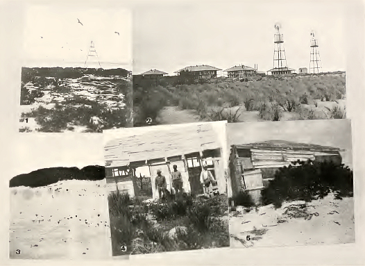
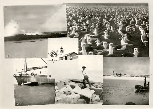
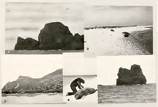
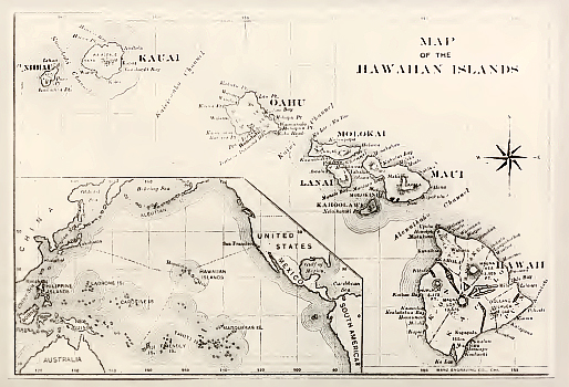
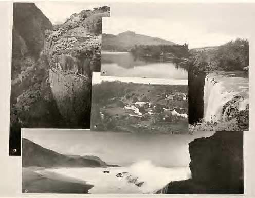
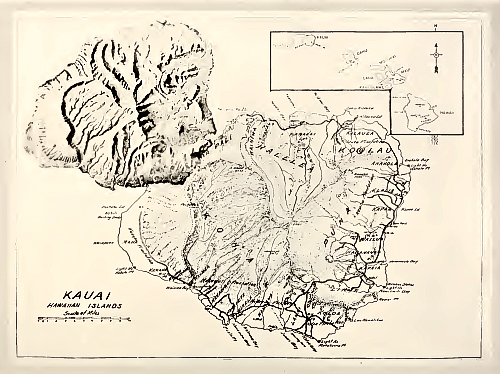
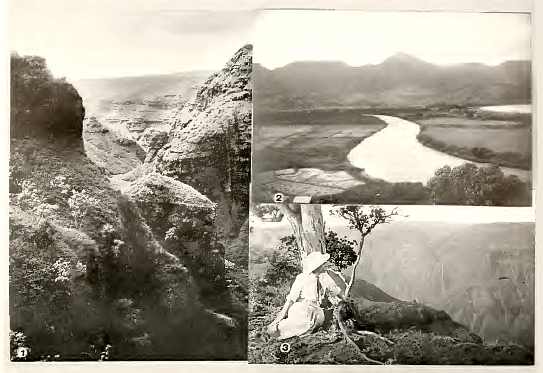
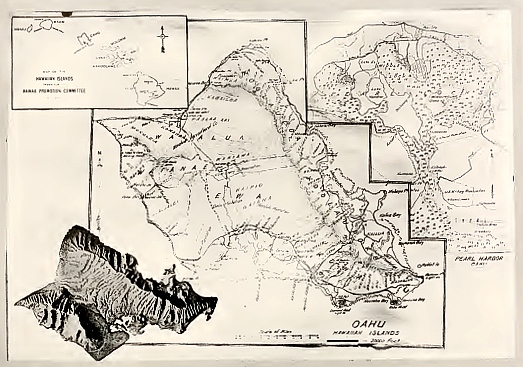
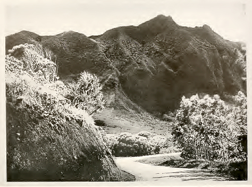
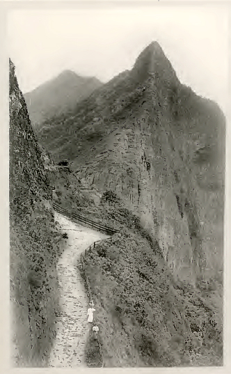
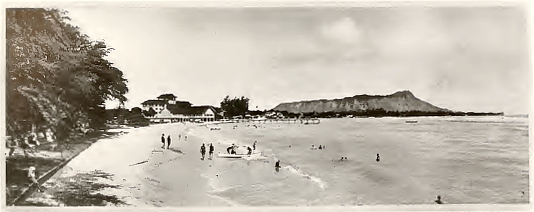
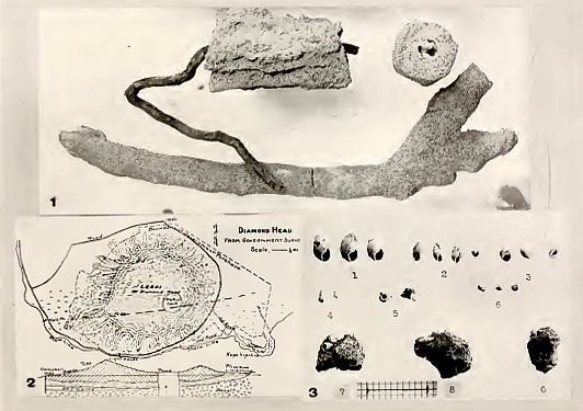
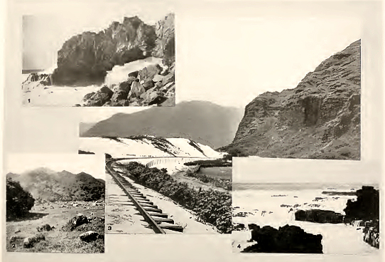
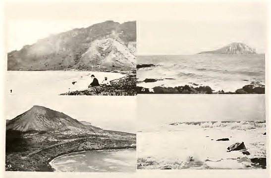
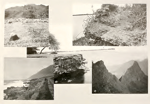
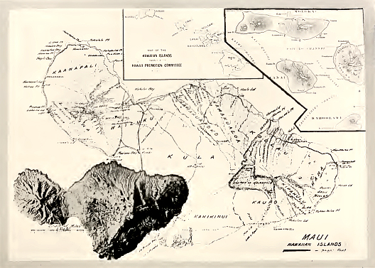
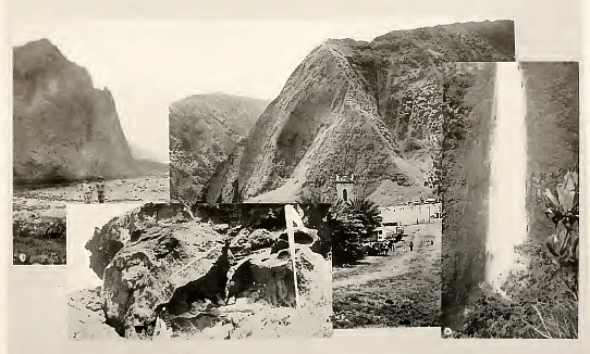
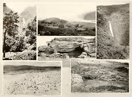
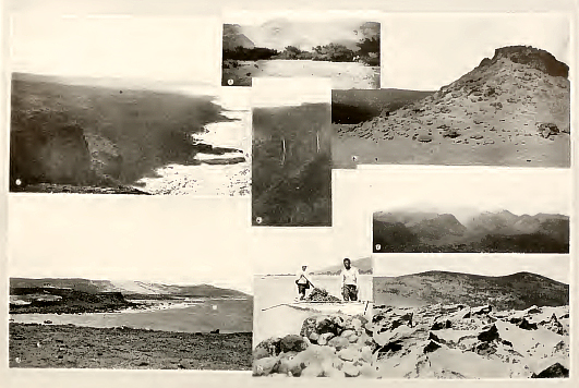
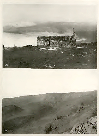
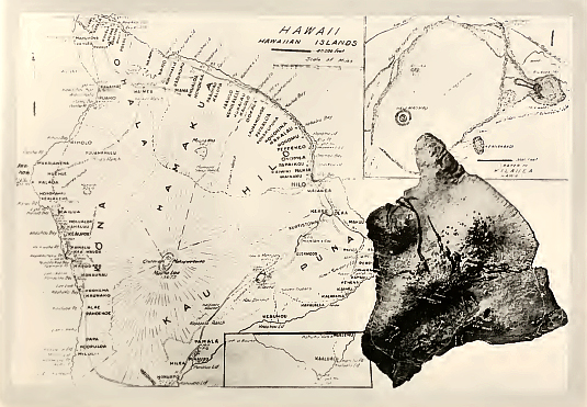
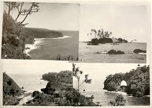
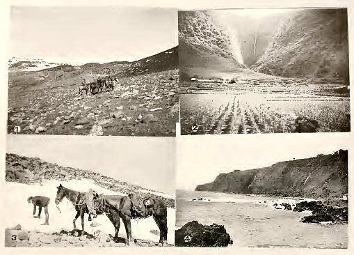
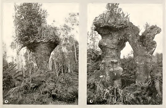
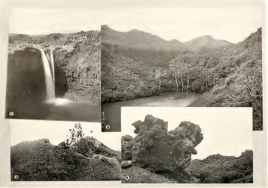
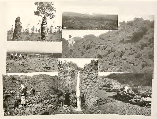
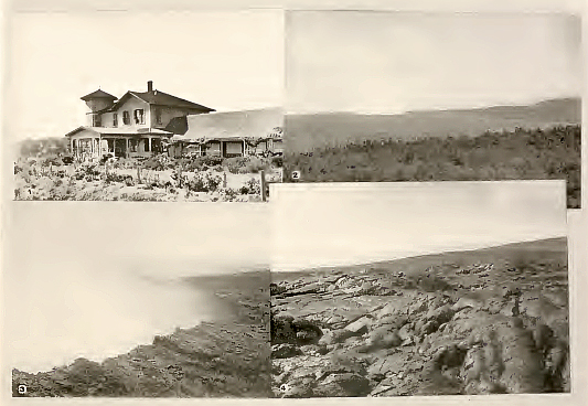
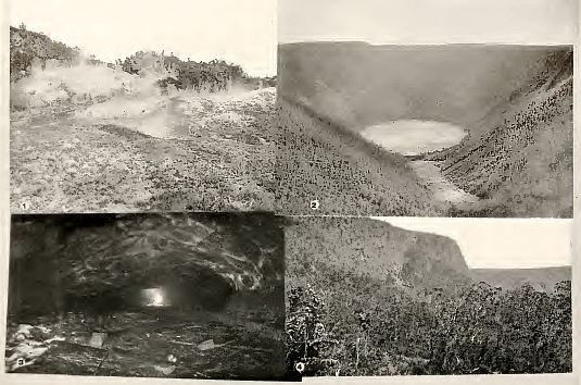
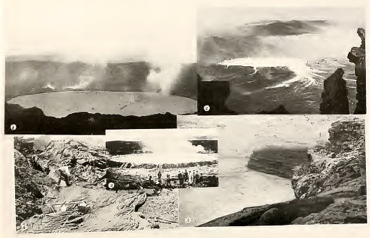
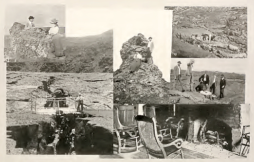
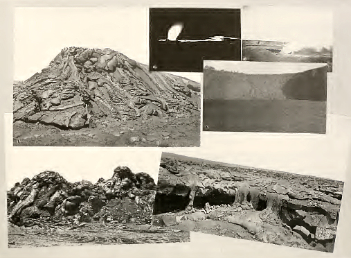
|
|
|
|
|
|
||
| History | Atlas | Culture | Language | Links |